
7.1 Introduction
In Chapter 2 the Sustainable Rural Livelihood approach was introduced, and in Chapter 5 ways in which risk and uncertainty in dryland environments are handled by modern pastoralists were described. This chapter builds on that information by focussing on how the SRL approach can be applied to archaeological data, selecting diagnostic elements supplied by published field reports in order to answer questions about livelihoods that shed light on risk management, sustainability and response to opportunities.
Three tasks were identified and are carried out below:
- Creation of a template for data collection
- Identification of indicators for the Asset Matrix components
- Demonstration of how a template is populated with data, using work-streams from the case studies as examples
7.2 Template for the Archaeological Analysis
When I completed a test case study on the Hadendowa of northeastern Sudan from the descriptions provided in Manger et al 1996 (an abridged version of which is in Appendix H), I created a template for presenting the output from the SRL model a structured way. The template was then adapted for archaeological data and is as follows, in table 7.1. It breaks the SRL model down into both a methodology for data collection and a format for presenting the data.
 Table 7.1 – Template for Presenting SRL Data
7.3 Building the Case Studies
Using the above template (table 7.1), criteria for assessment (table 7.5) and the proposed archaeological analogues for these indicators in Appendix G (Potential Archaeological Indicators) the case studies were assembled for each of the four localities. Although the format is very straight forward, populating of the template with data requires the assembly of the basic units of description, the material published about each locality, together with research that explores some of the issues raised within the SRL model. Some of the research, for example, into concepts of ethnicity and the best practices of herding for different types of locality, were applicable across all four case studies, whereas other issues, like the use of ceremonial complexes and the associated ideas of symbolic risk, were only fully applicable to the Nabta Play case study, and to a limited extent the rock art of the Gilf Kebir. The steps required to complete the model are now discussed, using summaries of data taken from the case studies to illustrate each aspect of how the SRL model is completed.
7.3.1 Introduction to the Case Study
Section 1 consists of a single paragraph of introduction, with national, regional and local maps to put the localities discussed into their geographical context.
Section 2 consists of three tables, listed in Table 7.1. Table 7.2 demonstrates the range of data for each case study. The data for Nabta, for example, is patchy with initial gaps identified in personal/symbolic objects, few settlement structures and a shortage (although not total absence) of human, faunal and botanical remains. At the same time, it is strong on inorganic assets like stone and ceramic tools, ceremonial structures. Although the table lacks detail and does not comment on the quality of the data, it is a useful tool for identifying where some of the gaps may lie before completing the model and for considering whether it is actually worth trying to apply the model to the data.
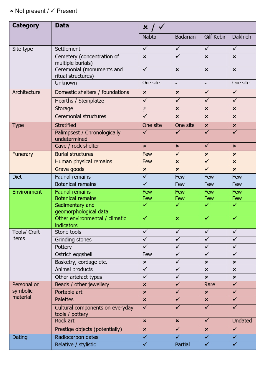 Table 7.2 – Data available for each of the case studies
The second table lists the main sites at the locality and provides a brief overview of their character (table 7.3, below). This provides a useful introductory summary of the type of archaeology present at the locality.
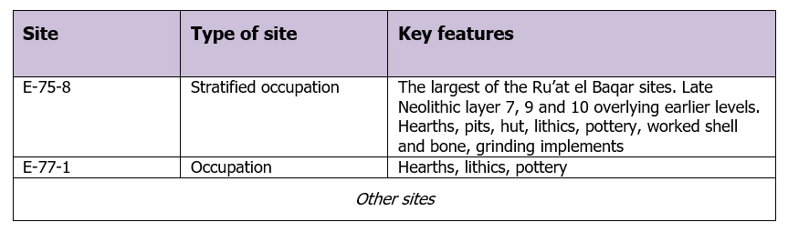 Table 7.3 – The main sites discussed in the case studies
are listed in a table in section 2
Finally the uncalibrated radiocarbon dates listed are included in another (here table 7.4), together with calibrations made using quickcal2007 ver1.5 (Cologne Radiocarbon Calibration and Paleoclimate Research Package (University of Cologne) http://www.calpal-online.de/index.html).
 Table 7.4 – Example, showing the radiocarbon dates available
for sites in the case studies
After these initial introductory steps have been taken, the SRL Model is completed, beginning with the Asset Matrix.
7.3.2 The Asset Matrix
The Asset Matrix is the descriptive element of the model, in which every category listed in table 7.1 is explored. As discussed in Chapter 2, the data provided in the Asset Matrix needs to be as detailed as possible to ensure that explanations are grounded in detailed knowledge of each locality. In anthropology and development economics, many of these fields of investigation, for example intra-group relationships, ethnicity, nutrition, types of mobility practiced, settlement structures, social hierarchies, can all be approached via observation and interviews. In archaeology proxies must be identified to explore these areas and these are captured in Appendix J. Table 7.5 lists criteria for assessing the components, a simple tool to ensure that all aspects of the asset matrix are captured. In the case studies, each of the indicators defines a sub-heading under each of the asset component headings.
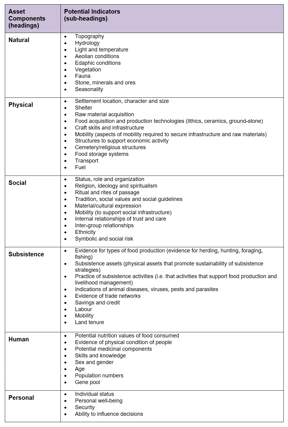 Table 7.5. Indicators for the Asset Matrix
In the following pages, (7.3.2 – 7.3.8) each of the above assets is defined and described, and illustrated with brief examples from the case studies.
7.3.3 Natural Assets
The Natural Assets category is described by the DFID (1999, p.11) as follows: “Natural capital is the term used for the natural resource stocks from which resource flows and services (e.g. nutrient cycling, erosion protection) useful for livelihoods are derived.” The Natural Assets category forms the environmental context for each case study, indicating the constraints and opportunities within which people lived their lives on a permanent and shifting basis.
In many ways the Natural Asset category is the most straight-forward to complete because it is an entirely empirical profile of an area under the sub-headings formed by the “Potential Indicators” in Table 7.5. In the Nabta Playa case study the information comes from a variety of sources, including archaeological research from survey and excavation reports, climatic, geographical, geological and geomorphological surveys. Additional research was required to improve understanding of environmental conditions by looking into the habitats preferred by plant and animal species recorded at the locality and what these said about seasonality.
The Natural Assets category is introduced with a table indicating types of environment available at each locality, shown here in table 7.6. Five hydrological zones are defined, comprising the full range of natural assets available in the case study areas. Zones that do not appear in a region in a case study are both scored through and greyed out. The purpose of the table is to give an instant impression of the landscape features that contribute to the hydrological character of the area.
 Table 7.6 – Natural Asset zones
In each case study the unique combinations of natural assets is then described. Capturing the environmental context is essential for exploring the types of choices that may have been available to the pastoralists who occupied the site, and understanding what sort of nutrition would have been provided by the locality.
In an area of largely undifferentiated desert with sandstone outcrops, Nabta sits on the edge of a natural depression with a number of basins that filled with rainwater in the summer months. The flora and fauna are examined with a view to understanding what the conditions may have been like during the Ru’at el Baqar period, and local geology is described so that sources of stone for tools may be identified. The Badarian, which flanks 35km of the Nile foodplain, which was flooded annually and was flanked by low desert that was intersected by wadis. It was a rich natural environment. In Dakhleh bimodal rainfall and permanent springs combined with a variety of topographical features and environmental niches gave the oasis a distinctive set of natural attributes. The Gilf Kebir, a 300m high plateau is characterized by deep dissected wadi systems, two of which were blocked by dune barriers to form seasonal lakes fed by rainfall regimes influenced by the local highland topography. In all the case studies, the unique combination of geology, geomorphology, environmental indicators and hydrology are all discussed. The four areas demonstrate the variety of landscapes and resources available to herders in the mid-Holocene eastern Sahara.
7.3.4 Physical Assets
Physical assets are described by the DFID (1999, p.13) as follows:
Physical capital comprises the basic infrastructure and producer goods needed to support livelihoods.
-
- Infrastructure consists of changes to the physical environment that help people to meet their basic needs and to be more productive.
- Producer goods are the tools and equipment that people use to function more productively.
At Nabta occupation data was assessed and was found to be fairly ephemeral, mainly hearths with surrounding surface scatters, with one deep stratified site that allows some degree of stratigraphic resolution (Close 2001; Nelson 2001). The only evidence of shelter is confined to one possible hut (Nelson 2001). Raw material for lithics, a key physical asset, is well represented in all the case studies. At Nabta this permitted a comparison of stone types that were available locally and those that were from further afield, providing insights into different approaches to stone tool acquisition.
During the Badarian both opportunistic and more specialist lithic technologies are introduced. Ceramics are a particular speciality of the Badarian and pottery manufacture is discussed in terms of what it might have contributed to subsistence activities and how pottery manufacture was organized. Craft infrastructure using organic matter, which has had to be inferred in other case studies, is present including matting, basketry and textiles in graves, as well as some items made of bone and ivory. For the first time there are model boats, suggesting that boats were used for transport of people, or goods, or for deep water fishing and the implications for Badarian life are examined in the case study. The presence of multiple types of decorative stone available only from the Eastern Desert is examined in terms of acquisition costs, as illustrated by the schematic in figure 7.1, which is discussed in the Badarian case study.
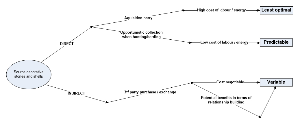 Figure 7.1 – Potential mechanisms for acquiring decorative stones
and shells from the Eastern Desert
During Gilf C ephemeral sites belonging to the Gilf C from a number of different topographical locations were excavated and are described. Raw material sources are discussed and used to consider different resource acquisition strategies for stone tools and ceramics.
The ephemeral Dakhleh sites are described and some of the difficulties with the data that they produce and the lack of raw material descriptions and images available in publications is highlighted as a problem with the analysis of the Bashendi B. The role of ceramics, their decoration and their origins, are examined with a view to shedding light on some of them connections that may have taken place beyond Dakhleh. Exotic stones and groundstone, neither of which were available within Dakhleh oasis, are also discussed in this context.
Toolkits in all case studies were discussed with a view to characterizing the industry in terms of costs and benefits following Shea’s analysis (2013, p.39-45) (see figure 7.2 below) and as “objects of thought” following Edmonds (1995, p.42). Groundstone and ceramics are also described and assessed, in terms of local verses imported objects and the relative significance of each.
 Figure 7.2 – Critera for assessing tool manufacturing strategy
(based on Shea 2013, p.39-45)
7.3.5 Social Assets
The Social Asset category is described by the DFID (1999, p.9) as follows:
There is much debate about what exactly is meant by the term ‘social capital’. In the context of the sustainable livelihoods framework it is taken to mean the social resources upon which people draw in pursuit of their livelihood objectives. These are developed through:
-
- networks and connectedness, either vertical (patron/client) or horizontal (between individuals with shared interests) that increase people’s trust and ability to work together and expand their access to wider institutions, such as political or civic bodies;
- membership of more formalised groups which often entails adherence to mutually-agreed or commonly accepted rules, norms and sanctions; and
- relationships of trust, reciprocity and exchanges that facilitate co-operation, reduce transaction costs and may provide the basis for informal safety nets amongst the poor
The development of the ceremonial centre at Nabta provides plenty of scope for a multi-layered discussion under this heading, together with an assessment of suggestions that it may include elements of a cattle cult (e.g. Brass 2003; di Lernia 2006; Herskovits 1926; Wengrow 2001), and Woods’s suggestion that there is evidence for shamanism (Woods 2016). Different types of social structure are considered and it is suggested that a plausible model for Nabta would be a heterarchy. The distinctive ceramics enable a discussion about where else the occupants of Nabta visited or were based, what sort of connections they may have had with Nile populations to the southeast and south and how these relationships may have impacted the material record of the Ru’at el-Baqar.
In the Badarian case study the presence of cemetery data, potentially a rich source of information, is somewhat undermined by the lack of an agreed chronology for the Badarian, as noted in chapter 6. The presence of numerous cemeteries suggests a strong affinity with the stretch of the east bank of the Nile along which they extend, and this feature is discussed in terms social organization, co-operation and a sense of place. The grave goods and some distinctive artefact types enable a discussion of concepts of religious belief, ideology, identity, ethnicity and social structure. The concept of tradition combined with innovation is explored by looking at both new elements and the survival of older practices. The contrast between the expedient character of the lithic industry and the investment in fine ceramics is assessed.
The Gilf C occupants of the Gilf Kebir took advantage of a dune playa and seasonal pasture. Although more archaeological investigation is needed in the neighbouring Jebel Uweinat, it has still been possible, mainly through the medium of rock art, to discuss concepts such as territoriality and management of relationships with other groups. Rock art images are dominated by livestock, with an emphasis on cattle, and offers the potential for raising questions of territoriality, nomadic routes through the landscape, as well as concepts of important places, ideology and religion.
The Bashendi B is the most difficult to assess although it initially seemed to have the most potential for looking at land use and the rules that governed access to desirable resources. The specialized bifacial tools are discussed in what information they may convey in the definition of a particular identity common to the oases. Ceramics are do not appear to have been a dominant component of cultural expression but their role is considered. There is little to suggest social complexity, but McDonald’s proposal that exotic stones are prestige goods (McDonald 1999; McDonald 2008) is discussed. Connections with other areas are investigated, suggested by bifacial tools, ceramics and exotic stones.
7.3.6 Subsistence Assets
The DFID has a category called “Financial Assets” (1999, p.15), which I have altered to Subsistence Assets in order to reflect a different economic paradigm for prehistory. The DFID describe their Financial Asset category as follows (DFID 1999, p.15):
Financial capital denotes the financial resources that people use to achieve their livelihood objectives. The definition used here is not economically robust in that it includes flows as well as stocks and it can contribute to consumption as well as production. However, it has been adopted to try to capture an important livelihood building block, namely the availability of cash or equivalent that enables people to adopt different livelihood strategies.
In the above definition the concepts of stocks (e.g. livestock, tradeable goods), consumption and production are relevant, all describing a situation where production may generate the ability to trade for alternative goods, adopt new livelihood strategies or where subsistence merely permits sustainability of livelihoods.
Nabta, which could only be occupied on a temporary basis, has evidence for the use of domesticated cattle, sheep and goat and wild animals (Gautier 1980; Gautier 2001), and some evidence for the gathering of plant foods (Barakat 2001; Wasylikowa 2001). The combined data is used to assess how subsistence practices may have been arranged at Nabta, and what the perceived benefits may have been in bringing livestock to the playa lake, and possible subsistence strategies are discussed in detail by comparison with ethnographic research.
The Badarian is discussed in terms of the equivocal nature of the data for cereal cultivation, and the low volume of skeletal remains of domesticated species. Settlement data is poor, and although there are what appear to be storage pits, a lack of surviving content makes their function debatable. Plausible risk management strategies and a possible seasonal schedule over a two year period are proposed (figure 7.3) and discussed in the case study.
 Figure 7.3. A seasonal schedule over 2 years, assuming the possibility
of cereal cultivation and herding. Based on Butzer 1976; Hassan 1984,
Midant-Reynes 1992, p.140 and Yokell 2014
There is only minimal subsistence data for Gilf C. Occupation remains are described in terms of settlement strategy. Potential stocking strategies are discussed based on site distribution and topography. McHugh’s functional analysis of tools at Gilf Kebir (1971) is used to fill out the range of activities that might have taken place. A consideration of labour requirements and organization is made, and the use of local knowledge and potential exchange of information are inferred from settlement patterns. The extent of the mobility of groups during Gilf C is also discussed, and within this context rock art is considered as a possible indicator of land tenure arrangements. A seasonal calendar, such as the one shown above for the Badarian (figure 7.3) is also attempted.
Dakhleh during the Bashendi B also lacks satisfactory subsistence data. Although the availability of water in various forms may suggest a strong foundation for subsistence activities, and the oasis is likely to have had rich plant foods available and would have had plenty of fuel, the ability to exploit those resources may have been limited by the constraining geographic circumstances under which groups lived. Potential stocking strategies within these constraints are proposed and archaeological data is combined with ethnographic data to suggest seasonal usage patterns of the oasis and its multiple topographies.
7.3.7 Human Assets
The DFID guidelines define human assets as follows: “Human capital represents the skills, knowledge, ability to labour and good health that together enable people to pursue different livelihood strategies and achieve their livelihood objectives” (DFID 1999, p.7). As well as water, daily nutritional requirements for humans are captured in Appendix F, but there are four main intake requirements: fat, carbohydrates, proteins and micronutrients consisting of minerals and vitamins (Bender 2014, p.1-2; Hale 2005, p.124). Protein has a role beyond providing energy, making up 14% of the human body and is required for growth in both foetus and child. Adults also have an ongoing requirement for protein because it breaks down in the body and needs to be replaced to maintain health (Bender 2014, p.31-33). At Nabta this would have been available from game hunting, with a minor intake from wild cereal grains, and any domesticated animals that were consumed. It was also present in animal blood, which could have been secured whilst the animal continued to live. Vitamins and minerals, only required in very small quantities, are usually only available from the diet because they cannot be manufactured by the human body (exceptions are vitamin D and niacin). Deficiencies in any of the essential minerals and vitamins can have serious results, described in Appendix F. Fats are not actually a dietary requirement but it is difficult to make up energy requirements from carbohydrates and protein alone, and malnutrition in developing countries is often caused by the lack of fat in the diet (Bender 2014, p.23).
This was the most difficult asset to assess, partly because judging human health is difficult even with good quality data. First, arid-dwellers have a high tolerance for poor nutrition so direct comparisons with Western models of nutrition are not always appropriate (Seeley 2006; Sen 1999) and there are also substantial differences in the requirements and tolerances of different groups and different areas (e.g. Galvin 2009) so that minimum nutritional intake requirements cannot be transposed directly from one region to another. Next, mobility, fluctuations in water availability and seasonality in plant availability (domesticated and wild) result in fluctuating nutritional intake, impacting the condition of people within the groups throughout the year. Drought will also influence availability of food, as can unusually high or low floods that deny riverside dwellers access to floodplain resources. The value of nutritional components (plants and animals) vary depending upon context, so any assessment of nutritional value from prehistoric remains is a very crude evaluation. Finally, in the areas under discussion, it is impossible to know which foods were preferred and which relegated to hunger foods, or even banned due to social proscription (Bender 2014, p.1-2; Cliggett 2005; Hobbs 1989, p.91; M.L. Smith 2006).
In the case studies the lack of human physical remains everywhere, except the Badarian, and the poor preservation of plant materials at most sites, meant that information on health and nutrition are sparse. Similarly, data about population size and demographics is largely unavailable. In spite of these difficulties, nutrition is important to understanding the potential for good health the overall quality of life of individuals so the findings of botanical and faunal remains in each of the case study areas is treated as a collection of options – the way in which people could have navigated the known nutritional possibilities at their disposal. All known species were considered as potential sources of food. No attempt has been made to follow the excellent example of Diehl (2015, p.353-353) to divide the plant remains into a number of resource groups and nor is there any attempt to distinguish between preferred foods and hunger foods. The quality of the data is simply insufficient.
The Badarian demonstrates the value of having human remains to supplement the remains of consumables. Zakrzewski’s stable isotope analysis and examination of dentition (2012) suggest that ground plant foods, particularly cereals, made up part of the diet. The presence of domesticated and wild animal species, aquatic resources and a mixture of different plant species would suggest that the people who occupied a 35km stretch of the Nile should be healthy, but another of Zakrzewski’s findings suggested that stunted growth was experienced by men and women of the Badarian, possibly caused by variable food availability (2003, p.225). At the same time, an analysis of skeletal remains (Stock et al 2011, p.359) suggest that there was a reduction of “habitual loading” of both the upper and lower limbs in males is consistent with a new type of livelihood, which Stock et al suggest is the adoption of agriculture in the Badarian region. This type of analysis, of which more would be helpful, can be combined with information about the environment and surviving plant and animal remains.
Data from Nabta suggests that occupants did not go short of good quality food. Although the use of wild cereals can be inferred from the large number of grinding items at the site, only a few conclusions can be drawn from the surviving botanical remains. The relative sizes of domesticates and wild species means that during the Ru’at el Baqar, cattle and small livestock made up around 85% of the meat diet (Gautier 2001, p.632). The significance of these findings is explored and the potential value of nutrition at Nabta is evaluated against the few remains.
Evidence for subsistence and human assets during the Gilf C are both rather poor but between wild and domesticated animals and wild plants, sufficient nutrients should have been available to enable the group to function normally for the short number of weeks that they occupied the Gilf Kebir.
The data for potential nutrients at Dakhleh is minimal, but suggests that reliable water in savannahh type conditions attracted both plants and animals that don’t occur in the other areas. What little survives suggests that fruits, wild cereals and fruit were available, providing basic essentials in the diet. Analysis of cattle bones at one site suggests that herds were kept for consumption, not merely dairy (McDonald 2002a). Domesticated livestock were supplemented by gazelle, hartebeest and carnivore species as well as freshwater molluscs providing a range of potential nutrients, discussed in the case study.
7.3.8 Personal Assets
The DFID guidelines were written prior to the addition of the Personal Asset by Hamilton-Peach and Townsley (2007) who introduced the new asset as follows: “It is intended to emphasise people’s internal motivations, their will to act and promote change (for themselves or others), their drive to assert their rights, and the spiritual side of their lives. It also incorporates their desire to engage in political activity (while “social” assets includes the mechanisms by which they may be able to articulate that activity)” (Hamilton-Peach and Townsley 2007, p.4).
The Personal Asset is the most nebulous of all the asset categories in prehistory. It is impossible to know what individuals considered to be desirable for personal utility. Basic health and safety seem to be the safest measures, although the ability to influence outcomes and acquire status may also have been increasingly important after domesticates were adopted and ideas of ownership and access rights to rangeland became more prominent.
In each of the case studies, the need for decisions in various parts of the livelihood and may suggest opportunities for contributing to the decision-making process, and these are considered. Sustainability is used as a measure of safety and security. Towards the end of the mid-Holocene, here as elsewhere, aridification may have introduced a certain level of anxiety about the ability to diversify geographically for economic, social and economic reasons. Where individuality is expressed, this may be imply that personal choices were possible, and this is discussed.
7.4 Livelihood Variables
The Livelihood Variables are made up of the Vulnerability Context, Opportunity and Livelihood Structures and Processes, all of them components that shape livelihoods.
The Vulnerability Context is defined by the DFID as follows:
The Vulnerability Context frames the external environment in which people exist. People’s livelihoods and the wider availability of assets are fundamentally affected by critical trends as well as by shocks and seasonality – over which they have limited or no control. (DFID 1999a).
The Vulnerability context may include changes to variables that could impact food production and social organization including, but not exclusive to: Changes to variables that enable food production and social organization including seasonality, resource shock (disease, drought, failed flood etc), unfavourable climate change, over-use of landscape, loss of skills/knowledge, population pressure and conflict. In each of the case studies the system devised by Nelson et al (2016) to assess overall vulnerability was used to explore the types of vulnerability that were experienced during the mid-Holocene. Naturally this has more chance of reflecting reality where there is a wide spectrum of data to assess, so the case study results were somewhat variable.
In the original SRL Model there is no reference to opportunity. In the original SRL model this would be incorporated into the Structures and Processes segment, because opportunities often derive from governments, institutions and their policies. In prehistoric contexts there are no formal mechanisms that determine where opportunities come from. I have therefore modified the SRL model to reflect this. Sources of opportunity may include: favourable climate change, new technologies, new economic resources, new natural resources and new ideas and skills. At Nabta, for example, the most likely scenario is that formerly nomadic pastoralists, confronted by deteriorating climate, chose to adopt new livelihood strategies and formed new links with other groups to improve sustainability.
Finally, the Livelihood Structures and Processes component diverges slightly from the original SRL model as shown in the DFID guidelines, adapted for use in archaeology. The DFID define this component as
The institutions, organisations, policies and legislation that shape livelihoods. Their importance cannot be overemphasised. They operate at all levels, from the household to the international arena, and in all spheres, from the most private to the most public. They effectively determine:
-
- access (to various types of capital, to livelihood strategies and to decision-making bodies and sources of influence);
- the terms of exchange between different types of capital; and
- returns (economic and otherwise) to any given livelihood strategy
In the DFID approach, this incorporates national government, regional government, state institutions, the private sector and NGOs and their laws and policies. These are not, however, relevant to prehistoric contexts, where structures and processes are sometimes framed within kinship networks but are often highly localized. Instead, the DFID categories have been replaced with: kinship, markets, law/tradition and regional politics, where “kinship networks” may influence access to resources, support, and decision-making bodies, where “law/tradition” refers to the agreed ideologies and rules by which people manage community behaviour, and “regional politics” is a broad brush referring to any recognized hierarchy or decision-making unit. In the case studies, each of the areas was assessed in terms of both what types of natural and human processes that could have influenced both the character of each period and the sources of those processes. This was the most frustrating part of the SRL model as applied to these case studies, as the data was simply insufficient to do much more than speculate.
7.5 Livelihood Outcomes
The DFID definition (DFID 1999a, p.25) is only useful up to a point in archaeology:
Livelihood Outcomes are the achievements or outputs of Livelihood Strategies. . . . In particular, we should not assume that people are entirely dedicated to maximising their income. Rather, we should recognise and seek to understand the richness of potential livelihood goals. This, in turn, will help us to understand people’s priorities, why they do what they do, and where the major constraints lie.
Whilst it provides a useful warning that livelihood strategies are based on more than economic gain, the techniques available to development researchers for extracting this material are not available to archaeologists. The DFID also defines outcomes as a hybrid between a community’s objectives and those of the DFID acting on the community’s behalf (DFID 1999a, p.25). Instead, “Outcomes” is defined here as the output of livelihood variables acting upon the asset matrix, a matter of interest for archaeologists who are intent on observing change rather than influencing it. This makes the SRL model a continual loop, with variables acting on assets and producing outcomes, right up until the point where a livelihood is no longer sustainable. In the case studies, increasing aridity meant that Nabta and the Gilf Kebir ceased to be habitable, but in the Badarian and Dakhleh, other options were available and the result, in each case, was a notable change in the material record. In the case of the Badarian this included an expansion of occupation out of the Qau el-Kebir – Matmar area, and a change of material output, with many surviving elements. In the case of Dakhleh, the Bashendi B disappears but the Sheik Muftah, representing an impoverished and highly mobile livelihood, was able to mete out a livelihood well into the Old Kingdom.
Although abandonment seems like a simple outcome, studies of migration have shown that it is far from straight forward, and may involve a variety of decisions along a continuum, from migratory drift at one end of the scale (Stenning 1957) to decisions at the household level about long distance migration, usually dependent upon contacts in destination areas (Cliggett 2005, Winkels and Adger 2002). Where no existing ties exist, incoming households and groups have no access to support networks and or rights to land, and conflicts may arise (Silberbauer 1981; Stenning 1957; Winkels and Adger 2002, p.6). In all cases, the trauma of abandoning livelihoods and familiar areas may cause social and ideological crisis (Cliggett 2005; Spencer 1998, chapter 5). A flow chart representing some of the choices that would have been available in the Gilf Kebi at this time is shown in figure 7.4. It is probable that after leaving the Gilf Kebir at least some of the occupants moved south to Laqiya, some 400km away (Kuper 2007, p.9). Similar flow diagrams for the choices available in the case study areas at the end of the mid Holocene are shown in Chapter 9.
 Figure 7.4 – Choices facing occupants of the Gilf Kebir at the end of the mid-Holocene
7.6 Key questions
The same questions will be asked in each of the case studies in order to bring out similarities and differences that will form the basis of a comparative study. They key questions are based on the research questions described in Chapter 1, and are informed by the analysis of risk and uncertainty in Chapter 5.
- What drew occupants into the area, or why did the occupation change?
- What types of risk (natural and human) were experienced
- How were risks managed?
- How can the livelihood be characterized in subsistence terms?
- Has it been possible to identify where decisions have been made and what they were?
- How has group identity manifested itself in the archaeological record?
- Were opportunities taken up in times of insecurity or stability?
- Can the livelihood be characterized as sustainable?
- Why was the area abandoned / why did the type of occupation change?
Key Question 2 is supported with table 7.7, which tabulates the best documented risk strategy options. Table 7.1 assembles the data presented in the case studies, based on the research into modern pastoralists described in Chapter 5, A simple yes/no/? rating is used to indicate presence or absence of a technique, together with a confidence rating in its presence of High (H), Medium (M) and Low (L). The table is used to begin a top-level assessment of the risk management strategies adopted in all four areas.
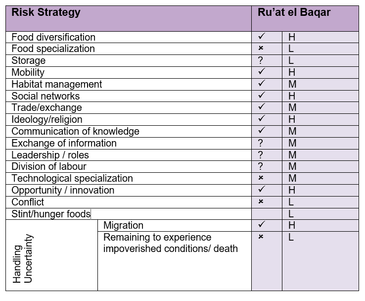 Table 7.7 – Risk management strategies employed at Nabta Playa
during the Ru’at el Baqar
7.7 Conclusions
In the introduction to this chapter it was stated that there were three tasks: 1) to describe the template, 2) to identify archaeological indicators for each of the asset components, using information taken from the case studies and 3) to demonstrate, with examples, the process by which the template is populated with data. This having been completed, the next task is to provide a case study to show the SRL approach in action by providing an abridged version of the Nabta Playa (Ru’at el Baqar) case study. This is provided in chapter 8. The next step was to use the data from all four case studies to compare the four areas in terms of vulnerability and sustainability, and this set of tasks is carried out in chapter 9.
