WORK IN PROGRESS
8.1 Introduction
This is an abridged version of the case study, and is half the size of the original, which was included on the attached CD-ROM and can be found on this site at https://polstudy.wordpress.com/case-study-1-nabta-playa-ruat-el-baqar. The chapter uses the SRL approach to examine and discuss the the Ru’at el-Baqar of Nabta Playa, also referred to by its excavators as the Late Neolithic. Background information about excavations at Nabta and its diachronic record have been introduced in Chapter 6. The Ru’at el-Baqar dates 7350 – 6600 Cal BP or 5400 – 4650 Cal BC. The site with the most complete stratigraphic record of the Nabta Playa archaeology, E-75-8, provides dates of 6550-5800bp (5200-4850 Cal BC). In this chapter published information has been combined within the framework of the SRL model to demonstrate the SRL approach and to explore the Ru’at el Baqar period.
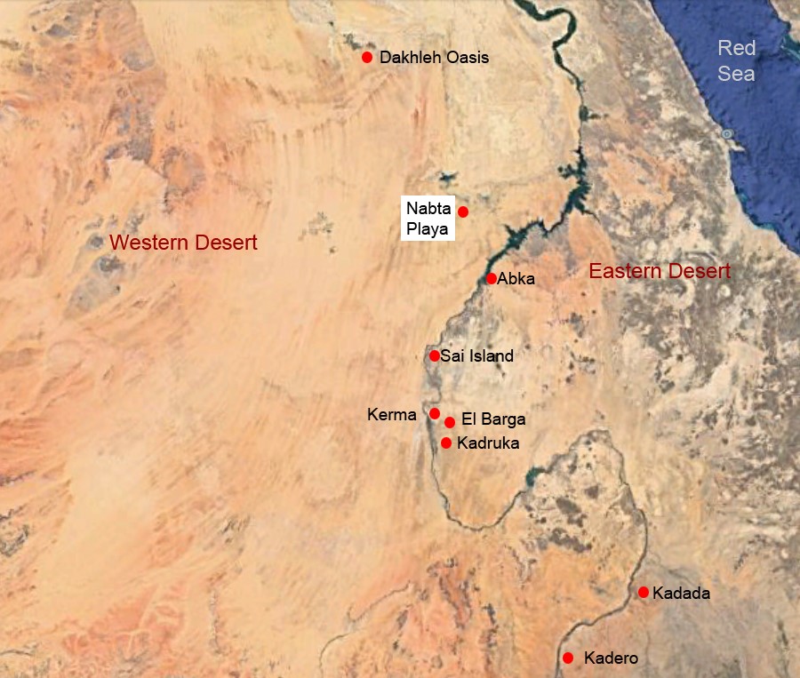 Figure 8.1 – The location of Nabta Playa, also showing other
places mentioned in the text (Source: Google Earth)
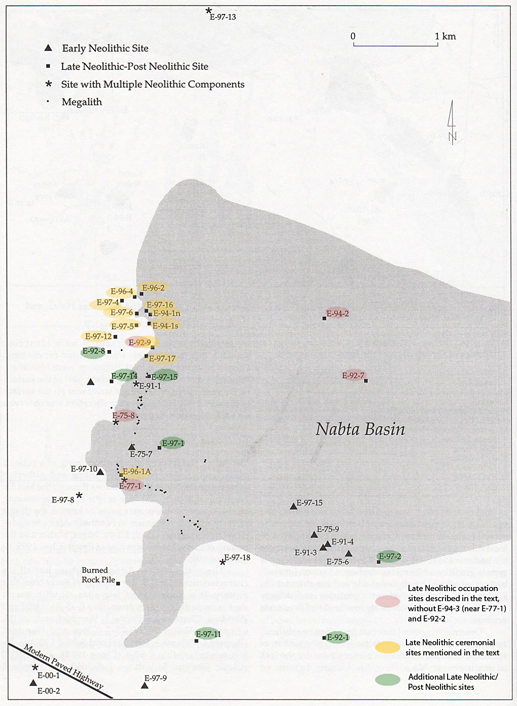 Figure 8.2 – Map of Nabta Playa. Modified from
Wendorf and Schild 2001a, fig 1.2, p.5
8.2 The data available for each phase
The main forms of data are summarized in Table 8.1, below. Variations in quality of that data will be discussed throughout the text. The sites discussed in the text are summarized in Table 8.2.
 Table 8.1 – Data types available for the Ru’at el-Baqar Late Neolithic
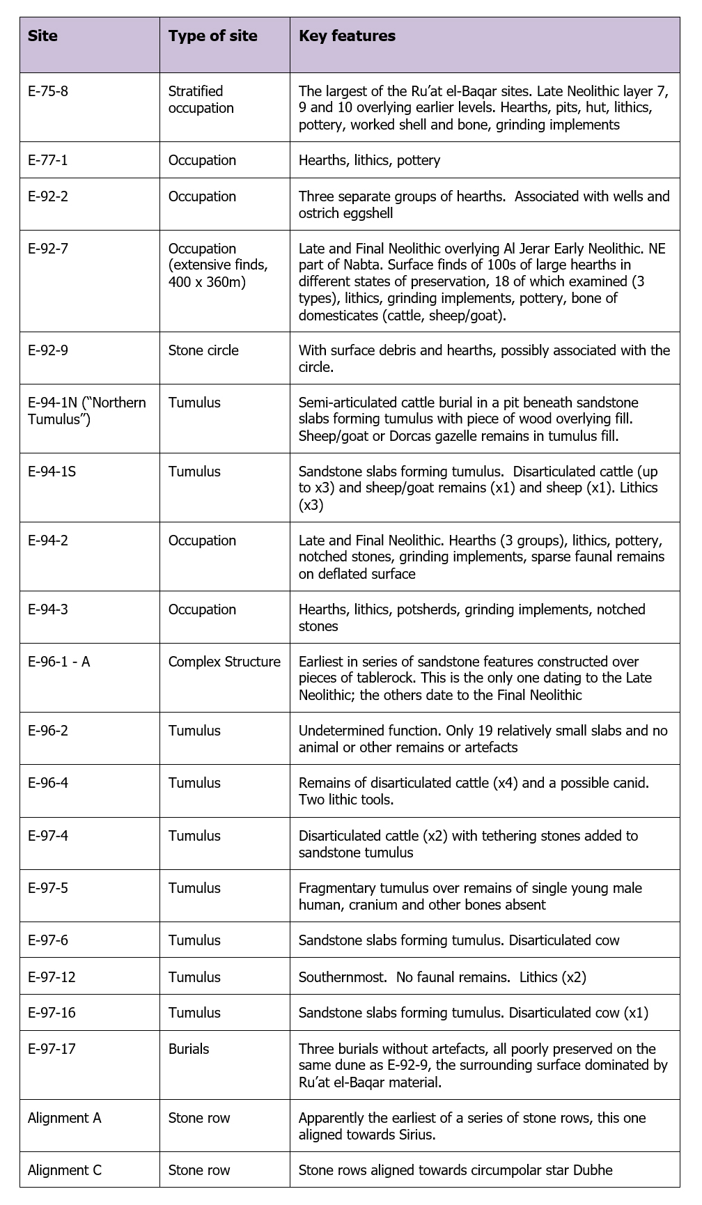 Table 8.2 – Ru’at el-Baqar Neolithic sites mentioned in the text
(Wendorf, Schild and Associates 2001)
Table 8.3 provides a list of the dates listed in Wendorf, Schild and Associates (Schild and Wendorf 2001c, p.53-54, Table 3.1) and calibrated using quickcal2007 ver1.5 (Cologne Radiocarbon Calibration and Paleoclimate Research Package (University of Cologne) http://www.calpal-online.de/index.html).
 Table 8.3 – Late Neolithic Radiocarbon Dates (Schild and Wendorf 2001, p.53-4, Table 3.1)
8.3 The Livelihood Status
8.3.1 Asset Matrix
8.3.1.1 Natural Assets
Table 8.4 summarizes the main types of zone available for exploitation during the Late Neolithic Ru’at el-Baqar, with zones unavailable shown greyed out and crossed through. These aspects of the landscape are discussed below.
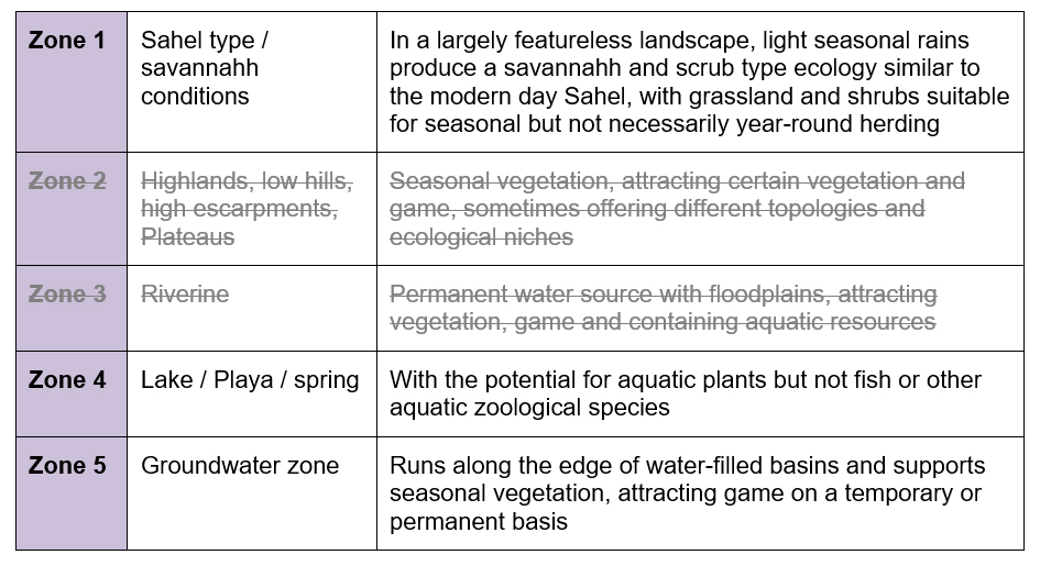 Table 8.4 – Natural Asset Zones
Topography
Nabta Playa sits between 22° and 23°N (latitude) and at 32°E (longitude). The central part of the basin measures 14km (east to west) by 10km (north to south) with wadis draining into the basin (Schild and Wendorf 2001b, p.11). A prominent hill called Gebel Nabta sits c.5km to the west of the playa, composed of Nubian sandstone capped with limestone, with another hill of the same composition 32km southwest of Gebel Nabta (Wendorf and Schild 1980, p.82). The surface of Nabta Playa is characterized by sands that stretch in plains interrupted by scarps, low sand dunes, some of them forming strings, and higher fossil phytogenic sand dunes (Schild and Wendorf 2001b; p.11; Wendorf and Schild 1980, p.82). Nubian sandstone forms the bedrock of the Nabta area and appears on the surface in outcrops. Other outcrops of durable basement complex occur to the north and northeast, including pink granite (Wendorf and Schild 1980, p.82). The basement complex is the oldest layer of rock in Egypt, comprised of Pre-Cambrian and Cambrian igneous and metamorphic rocks (Sampsell 2003, p.17). Nubia Formation sandstone and shales form small rises in the east, south and west (Schild and Wendorf 2001b, p.11-2). Approximately 200km to the north, is an Eocene scarp and plateau, c.90m high, formed of Eocene limestone with sandstones, shales and marls. The average elevation of the Nabta area is 240m above sea level (Wendorf and Schild 1980, p.83). The landscape is marked by numerous basins and sand-infested wadis (Wendorf and Schild 1980, p.82, 84).
Hydrology
The main source of water at Nabta Playa was rainfall that collected in basins and remained in place before evaporation eventually dried them out (Schild and Wendorf 2013, p.128). A wadi to the northwest of the basin, the “Valley of the Sacrifices,” was the main low-energy drainage route by which water drained into the main Nabta basin (Wendorf and Schild 2004, p.11, p.44-45). The entire basin was not flooded, but water filled sub-basins (Mohamed 2001, p.426; Schild and Wendorf 2001b, p.45). Water was also held in the deep sandy substratum adjacent to impermeable layers, again meaning that wells could be employed to access water as it retreated (Kobusiewicz 2003, p.97; Schild and Wendorf 2001b, p.47). Sites E-77-1 and E-94-3 were both located on the site of a wadi that became blocked by sand dunes and into which water drained and became trapped, potentially forming deep seasonal lakes depending on rainfall (Wendorf and Schild 2001c, p.427). In the plains of the Western Desert there was little topographical variation to shelter open areas of water from severe evaporation (Kröpelin 2005, p.51). The Nile was only one to three days walk from Nabta Playa, providing another potential water source for the occupants of Nabta.
Edaphic Conditions
Ibrahim and Ibrahim (2003, p.52-3) describe desert soils in Egypt as aridisols and sandy-rocky desert surfaces with low humus content, little biological activity and coarse to medium texture. Mid-Holocene conditions would have been superior, with some perennial vegetation helping to secure soil and build up a certain amount of topsoil. The underlying sandy soils can produce earlier and fast-growing species, which is of benefit to herders (Schareika 2003, p.20). Animal dung may have contributed to the quality of the soil in rangelands, particularly in places where animals sheltered from the sun.
Vegetation
During the mid-Holocene the Western Desert consisted of dry savannah, with Sahelian type conditions, consisting of “just a little grass after the rains in the summer” (Schild and Wendorf 2004, p.11). The species represented in the archaeological record at Nabta are shown in Table 8.5.
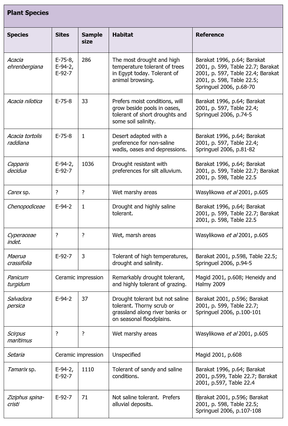 Table 8.5 – Plant taxa present in the Ru’at el-Baqar
Heavy deflation and poor survival of plant remains prevent the reconstruction of the botanical profile at Nabta, but the few remains provide a useful insight into the local environment. The species shown in table 8.5 are typical of arid and semi-arid environments. Their saline-tolerant root systems form phytogenic hillocks and pioneer water beds, wells, depressions, wadis and water tables up to 8m deep (Barakat 2001, p.596). At E-75-8 Acacia taxa were well represented. Acacia is very resilient in arid environments where it shares an environment with pastoralists, in spite of frequently intensive grazing. Seeds are propagated by browsing herbivores, meaning that acacia has a high recovery rate (Selemani et al 2013, p.146). Tamarisk taxa pioneer around open water bodies, wells and in wadis and are saline tolerant. Sedges from E-75-8 and club-rush, suggest marshy environments along playa edges (Barakat 1996, p.64; Barakat 2001; Wasylikowa et al 2001). At E-94-2 charcoals from all hearths produced Tamarix sp., Acacia ehrenbergiana, Capparis decidua, Salvadora persica and chenopodiaceae, showing a tendency towards contracting desert vegetation (Barakat 2001, p.598). Schild and Wendorf summarize this as “contracted groundwater-bound desert vegetation” (2001b, p.49).
Fauna
The species present in the archaeological record are shown below in Table 8.6 in sample size order, assembled from Gautier (2001, table 23.1, p.610-611, p.612-629), showing the type of environment to which the represented species were adapted.
 Table 8.6 – Animal species present in the Ru’at el-Baqar (MNI)
As with the plant species from Nabta, faunal species were arid-adapted, again indicating that this was a very marginal environment.
Stone, minerals and ores
Although the Western Desert seems fairly barren of stone at first glance, Nabta lies on Nubian Formation Sandstone, which is plentiful in outcrops. Additional sandstone and shale outcrops are found to the east, south and west (Schild and Wendorf 2001, p.11). Intrusions of igneous rocks from the basement complex can be found in the vicinity, notably granite (Schild and Wendorf 2001, p.11; Zedeño 2002, p.54). Observations on the ground indicate that most of the stones used at Nabta were available locally, including chert. The nearest source of flint for stone tools was a limestone escarpment 70km to the north (Krölik and Fiedorczuk 2001, p.340; Mohamed 2001, p.422).
8.3.1.2 Physical Assets
Occupation location, character and size
Unlike the Early and Middle Neolithic at Nabta, during which settlement structures were constructed, the Ru’at el Baqar Late Neolithic has a far more ephemeral settlement arrangement. The most prominent and durable remnants of occupation are deflated hearths, where only the lower portions were well preserved (Krölik and Fiedorczuk 2001; Schild and Wendorf 2001b, p.38). Hearths were apparently unenclosed and were used for only brief periods (Wendorf and Schild 2001c), but some of them were very substantial, although usually quite shallow, with carefully shaped profiles, and were often stone-lined. The hearths (figures 8.3 and 8.4) were accompanied by other deflated occupation remains, including surface scatters of lithics, ceramics, grinding equipment, occasional tethering stones and some bone fragments (Krölik and Fiedorczuk 2001; Schild and Wendorf 2001b, p.37. Some were covered with stone, presumably to protect them for future visits. Three wells were associated with E-94-2. Occupation appears to have been brief, but hearths and grinding stones formed site furniture indicative of the intention to return, exemplified by E-75-8 (Close 2001), E-77-1 (Wendorf and Schild 2001b), E-92-2, E-92-7 (Krölik and Fiedorczuk 2001), E-92-9 (Applegate and Zedeño 2001), E-94-2 (Mohamed 2001) and E-94-3 (Wendorf and Schild 2001b), which are described in the full case study.
 Figure 8.3 – Site E-92-7. Area A Hearths 9 and 10.
(Source: Krölik and Fiedorczuk 2001 p.343, fig 9.10)
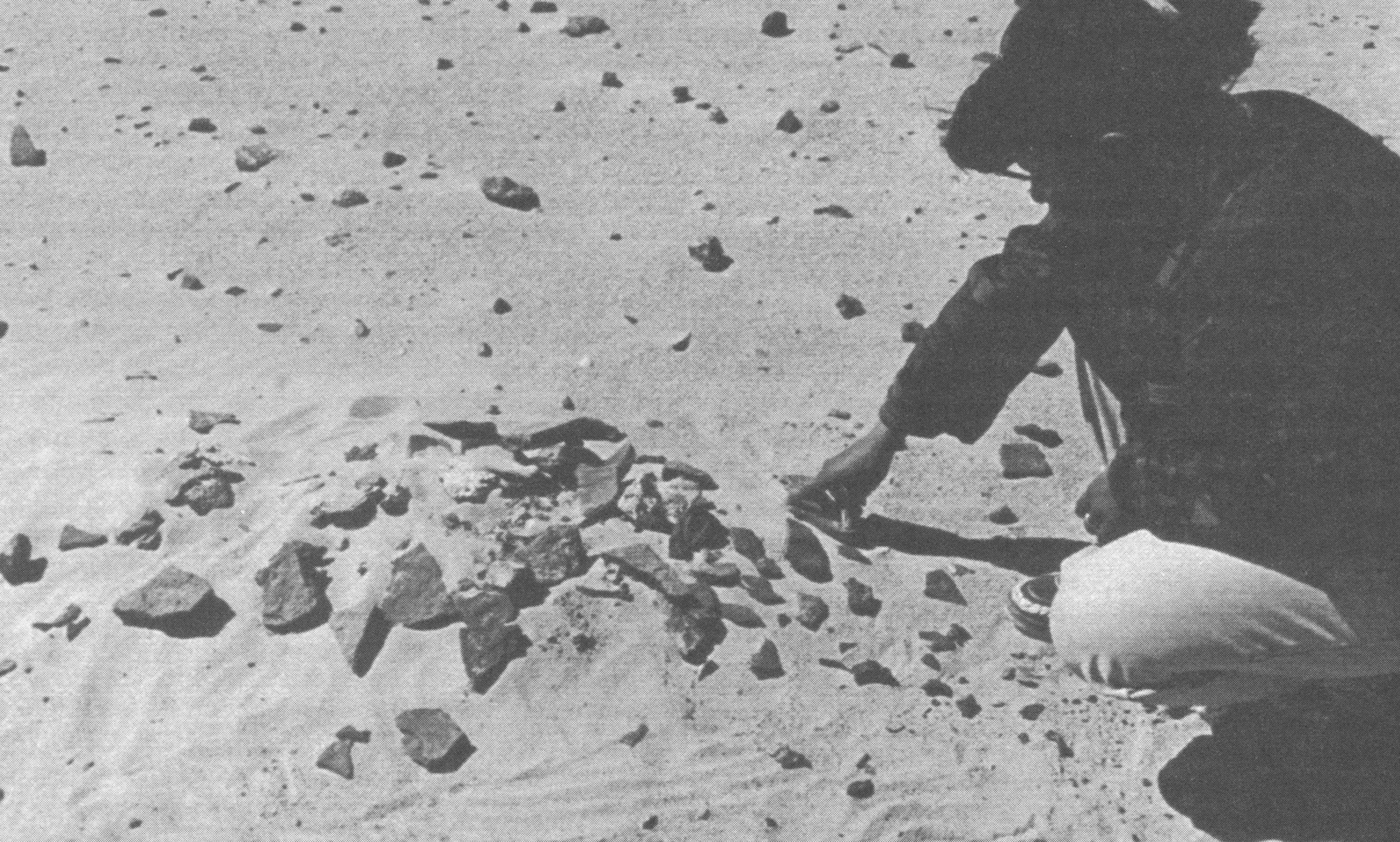 Figure 8.4 – Site E-94-3, showing a small stone-filled hearth before excavation
(Source: Mohamed 2001, p.456, p.figure 13.14)
Nabta is a good example of what Schlanger (1992) refers to as a “persistent place,” a concept that has been used in many studies since that date, and incorporates the idea that certain localities were used repeatedly over the long term, due to their suitability of their particular characteristics for certain activities, natural features that attract repeated occupation and the accumulation of material remains at those localities (Schlanger 1992, p.91). At Nabta, groups were drawn repeatedly to the rain-activated playa basin and the resource potential of pasture and game. Repeat visits date from the beginning of the early Holocene to the end of the middle Holocene. Hofman emphasizes that repeated use of the same areas and sites reinforces knowledge about those areas and improves the chances of livelihood sustainability means that scheduled return visits are desirable (Hofman 1994), whilst Hunn and B. Smith both describe how this type of knowledge becomes embedded in traditions based on a background of memory and past experience (Hunn 1993, p.13; B. Smith 2011, p.263), which also contribute to sustainability.
Shelter
Nelson (2001, p.389-391) describes a possible hut, Hut 1, at E-75-8, which was semi-subterranean and accompanied by a stone-lined hearth and two pits. It is the only known example dating to the Ru’at el-Baqar and its purpose is unknown.
Raw material acquisition
The following graph (figure 8.5) shows debitage raw material frequencies at three excavations reported in Wendorf, Schild and Associates 2001 (Table 9.9, p.346; Table 10.5, p.364; Table 11.5, p.402), indicating a dominance of quartz, followed by flint and chert. Unfortunately raw materials frequencies were not shown for all sites, so could not be compared, but this does indicate that quartz often replaced flint, which had dominated in the Ru’at el-Ghanam Middle Neolithic.
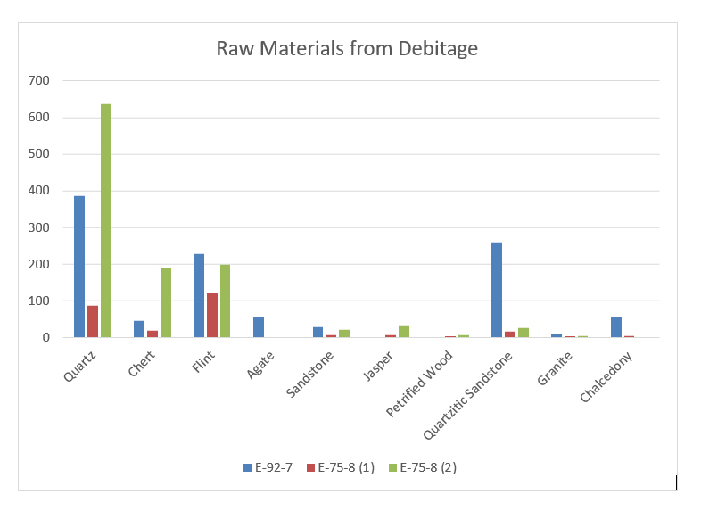 Figure 8.5 – Raw materials found in debitage at three sites at Nabta Playa
in the Late Neolithic (totals compiled from Wendorf, Schild and Associates 2001,
tables 9.9, p.346; 10.5, p.364; 11.5, p.402).
Apart from the excavations by Nelson (2001), (referred to in the graph as E-75-8(2) to distinguish it from the excavations by Close (2001) referred to as E-75-8(1), quartz is at least as important as flint and often more so. Agate and jasper were not available locally and although Krölik and Fiedorczuk (2001) mention that it may have been sourced from the Nile, it is equally possible that it came from the Eastern Desert, where it is certainly found (Aston et al 2000). Specialized knowledge may have been required to identify and locate the material. Otherwise no particular difficulty was associated with the acquisition of appropriate materials for tool manufacture. Chert, petrified wood, quartz and quartzitic sandstone, the main materials used, were available within a 10km distance (Wendorf and Schild 2001c, p.435). Chalcedony, used to make a number of microliths, was probably available locally in the form of small pebbles in playa silts and wash (Nelson 2001, p.395). Flint required no special skills to identify but its nearest source was 70km to the north of Nabta (Mohamed 2001, p.422; Krölik and Fiedorczuk 2001, p.340).
Ground-stone equipment was made of sandstone, granite and basalt, which were available locally (Wendorf and Schild 2001c).
The tumuli and the stone circle were made of the local Nubian Formation sandstone, which was in plentiful supply (Schild and Wendorf 2001b, p.11). It may have been selected to ensure the durability of the structures themselves, or because more pliable materials, like wood, were in short supply.
Food acquisition and production technologies
Lithic tool technologies
The main fabric to survive in the form of implements is stone. As above, most tools were made partly on locally available materials but flint was also important, which was not available locally, and there are some from outlying areas as well, particularly agate and jasper. At E-92-7, 1060 pieces of debitage, were found, as well as 57 cores and 72 retouched tools made on quartz, quartzitic sandstone and flint (materials that made up 83.8% of the total debitage), as well as agate, chert and chalcedony. Of the cores, most were single platform cores, but multiple platform, opposed platform are also found, most of very similar size and made mainly on quartz and flint. Of the retouched tools, dominant forms are notched flakes, denticulated blades and denticulated flakes, making up nearly half of the tools, but some microliths in a range of forms are also present, including 20 pieces with continuous retouch. Debitage at E-75-8 consisted primarily of flakes, with blades in a minority. Single platform cores again dominate at 58% of the total cores, with ninety-degree platforms next (17.2%) and the other types making up less than 10% between them (Close 2001). Examples of lithic tools are shown in figures 8.6, 8.7 and 8.9.
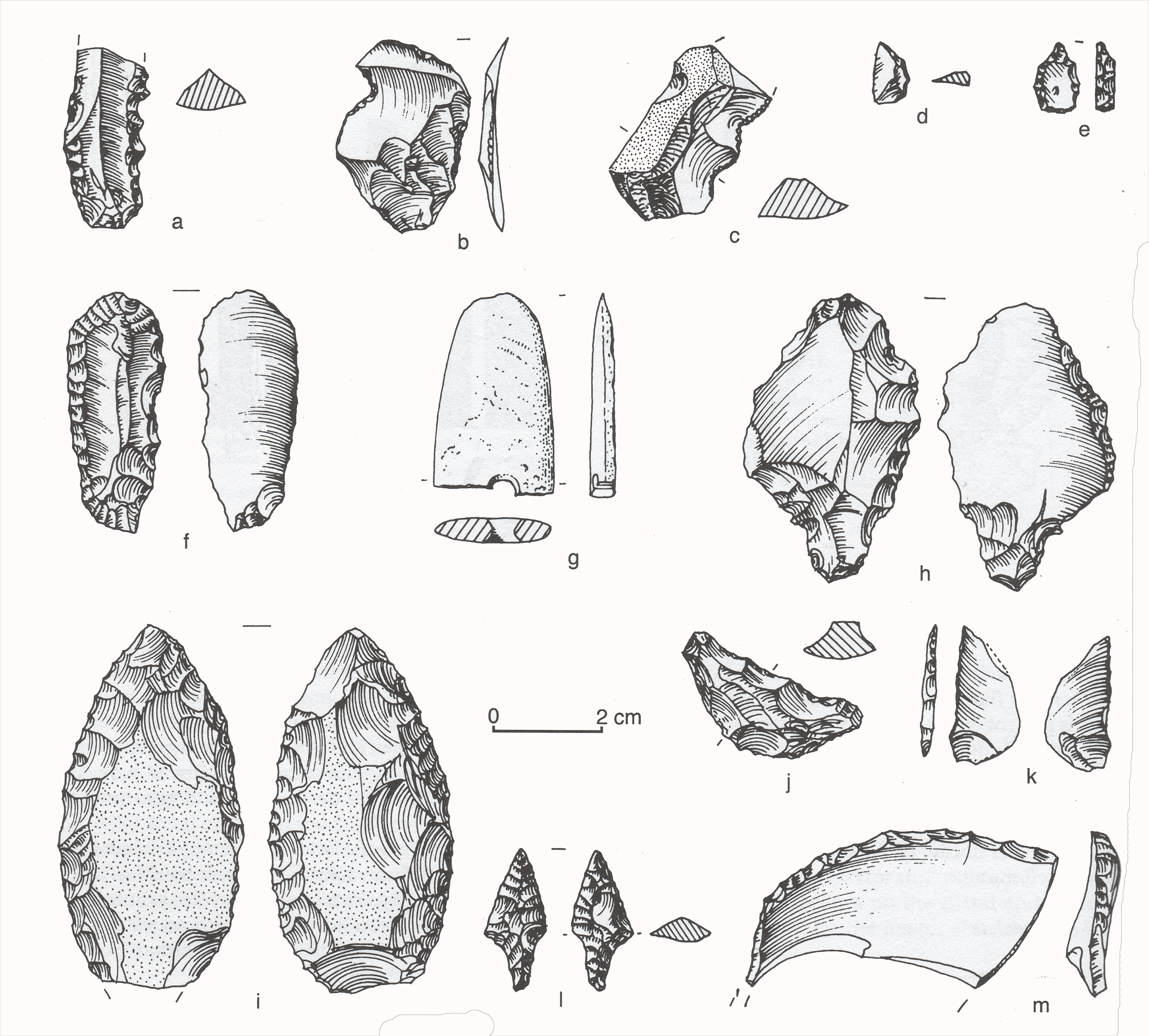 Figure 8.6 – A selection of Ru’at el Baqar lithics from E-75-8 (Nelson 2001, p.396).
a, c denticulates; b, notch; d, lunate; e, varia; f, endscraper; g, groundstone;
h, retouched Aterian point; i, biface; j, crescent/lunate; k, backed piece;
l, bifacial projectile point; m, retouched side-blow flake
Different techniques were used for reducing fine-grained and quartz cores and for the use of primary, secondary and tertiary flakes (Close 2001, p.376), with quartz largely left without retouch, indicating that different materials had different roles and were perceived differently. There was very low usage of coarser materials and these too were treated differently from quartz and fine-grained materials (Close 2001, p.376). Whilst materials changed, the need for fine-grained materials remained the same (Close 2001, p.375; Nelson 2001, p.401). Materials were clearly carefully selected for different roles in the subsistence strategy. Wendorf and Schild (2001c, p.438) suggest that the shift from flint and chert in the Ru’at el-Ghanam Middle Neolithic to quartz in the Ru’at el-Baqar may be due to technological changes accompanying the shift from blades to flakes.
Of the retouched tools, dominant forms are notched flakes, denticulated blades and denticulated flakes, truncations, and projectile points but some microliths are also present, including pieces with continuous retouch. There are no burins and only very few microliths, most of which were made on fine-grained and easily worked chalcedony (Nelson 2001, p.395). Geometric microliths are rare (Close 2001; Nelson 2001, p.401-403). Sideblow flakes appear for the first time at Nabta (e.g. figure 8.6-m), as do bifacial tools (figure 8.6-l, 8.7-d) (Nelson 2001, p.410).
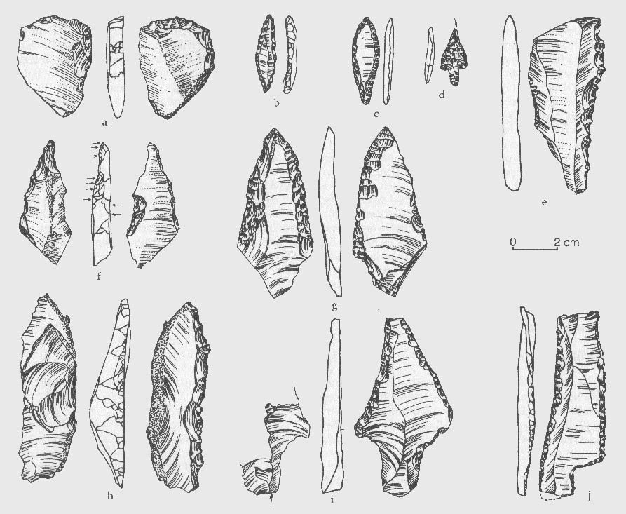 Figure 8.7 – Site E-94-3 Retouched Tools. a, endscraper on reused Levallois flake.
b and f, perforators; c and d, points; e and h, denticulates; g, i and j pieces with
continuous retouch (Source: Mohamed 2001, p. 459, figure 13.15)
Considering the assemblage in terms of Shea’s cost benefit analysis (figure 8.8) the industry of the Ru’at el-Baqar is “a less skilled and less formal, almost casual, character” than the Ru’at el-Ghanam Middle Neolithic, perhaps indicating that Late Neolithic stone working was either less important or that the strong sharp edges available without effort on quartz became particularly desirable (Wendorf and Schild 2001c, p.438): “With little energy investment in the acquisition of this raw material, informal quartz flakes could be produced, used and discarded at minimum cost” (2001c, p.440). The industry is one of minimal investment of time and energy, representing a low risk strategy. Tools were versatile rather than specialized, although the tasks for which they were required may have been highly specific, requiring large numbers of denticulates and notches, and some bifacial tools as well as a selection of other tools in smaller numbers. The dominance of single platform cores, making up 58% of the assemblage (Close 2001) also argues for an opportunistic approach to tool manufacture, with low cases of either core or tool curation. However, emphasis was placed not only on tool manufacture but on raw materials on which certain tools were made (figure 8.5) and represents more investment in output than the manufacturing approach implies.
 Figure 8.8 – Critera for assessing tool manufactruing strategy
(based on Shea 2013, p.39-45)
At the same time, bifacially worked tools appear for the first time, suggesting a dichotomy between a high level of expedient optimization on the dominant part of the assemblage and an intensified effort in a very limited part of the assemblage. These may fit into the category of “objects of thought” defined by Edmonds as partly symbolic as well as portable and functional, requiring a high degree of preparation and anticipation (Edmonds 1995, p.42) or demonstrating an affiliation with certain tasks, ideas, or areas or a combination of task-related production and cultural outputs.
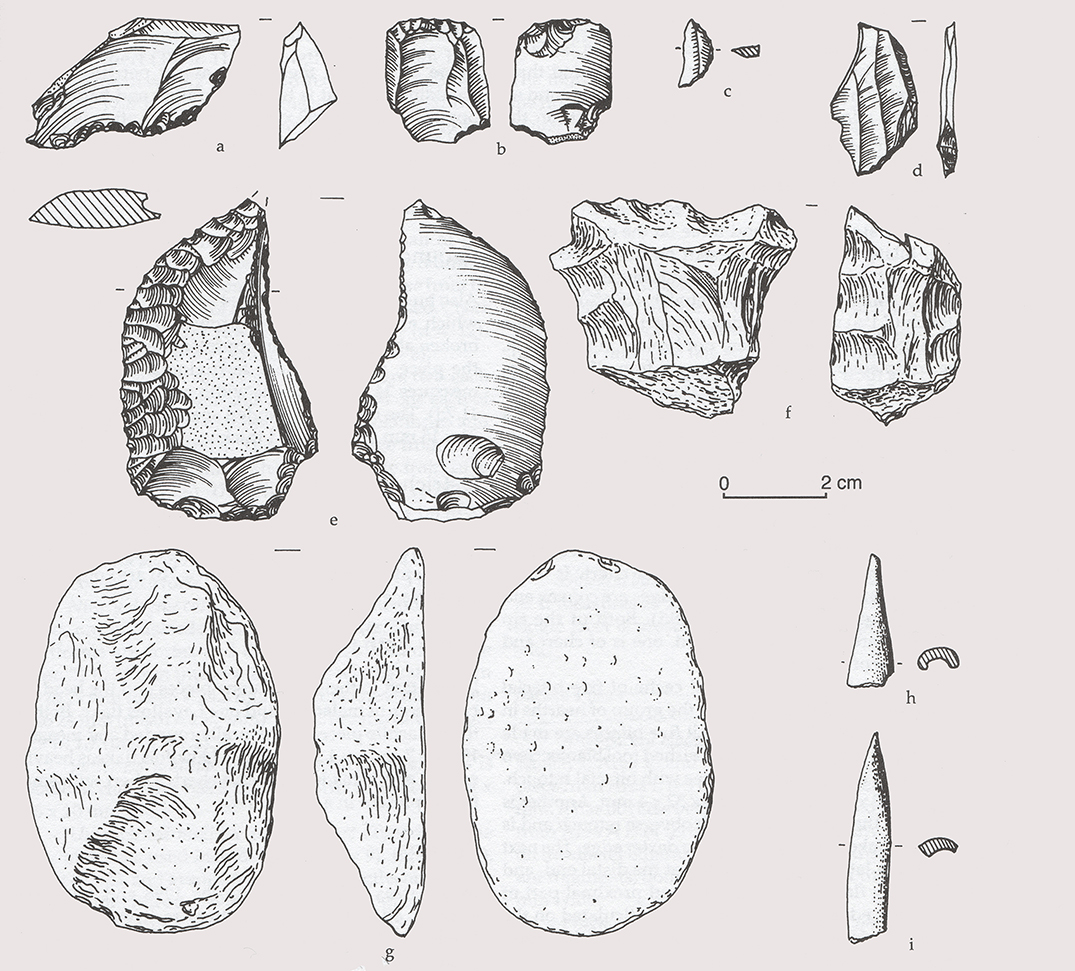 Figure 8.9 – Lithics and worked bone from E-75-8 (Source: Nelson 2001, p.399,
figure 11.10. a, perforator; b, endscraper; c, lunate; d, truncation;
e, retouched piece; f, denticulate; g, groundsetone; h,i, worked bone.
Groundstone equipment
Grinding implements were made of sandstone, quarzitic sandstone, granite, petrified wood, basalt, and quartz (Close 2001, p.382; Nelson 2001, p.403). Examples are shown in figures 8.6-g, 8.9-g and 8.10. The shapes varied considerably, as did the sizes, but most featured shallow dips in the surface. Some had grinding areas on opposing surfaces and one had two grinding areas on the same surface. Lack of standardization suggests that grinding equipment was made by individual households and that there was no cultural pressure towards uniform types.
Throughout the Late Neolithic, large notched stones were found (e.g. figure 8.10-c), but they are particularly prominent at E-94-2, where 22 were found, made of Nubia sandstone with two or more notches midway along opposing edges. They are found near the hearths and it is proposed that they may have been tethering stones (Mohamed 2001, p.424).
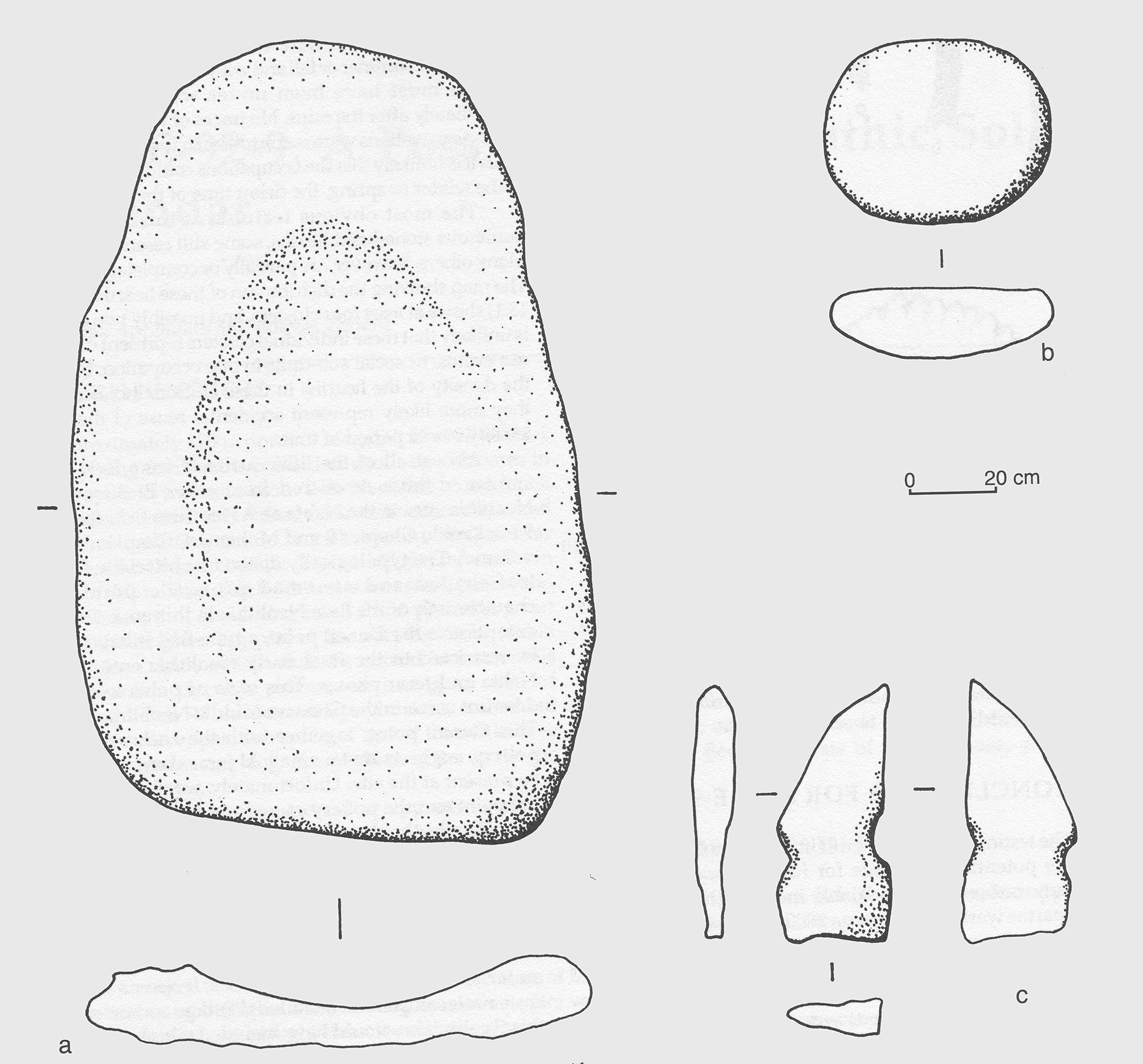 Figure 8.10 – Site E-94-3. Groundstone artefacts. a, milling stone; b, handstone;
c, notched stone (Source: Mohamed 2001, p.461, figure 13.16)
At E-75-8 two items described as palettes were found. They were unknown in the Ru’at el-Ghanam Middle Neolithic so are an innovation in the Ru’at el-Baqar. Both are made of coarse-grained sandstone which was pecked into shape, producing thin artefacts, one that was sub-rectangular and one sub-circular.
Ceramic container technologies
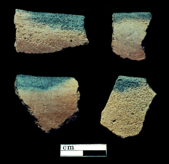 Figure 8.11 – Black-topped pottery
(Source: Nelson and Khalifa 2001, p.148, figure 4)
Whilst the changes to lithic technology were relatively minor, the differences between the Ru’at el-Ghanam Middle Neolithic and Ru’at el-Baqar ceramics were considerable. Following an eastern Saharan rocker-stamped tradition established in the Early Neolithic and retained throughout the Ru’at el-Ghanam, a range of new ceramics was introduced in the Ru’at el-Baqar, showing “no points of resemblance” to earlier forms (Zedeño 2002, p.52). The new hand-made, coiled types are characterized by fine paste, a relatively small volume of fine temper made of ground sherds minerals, sand and/or organic materials. Vessels were usually small and beaker-shaped although there were some small bowls, with thin walls less than 7mm thick, which show the first evidence of controlled firing (Nelson 2002a, p.7). Whole-surface treatments included the use of burnishing, smoothing, scraping and slipping, often in combination (Nelson 2002a, p.7). These comprise Black-topped Ware (figure 8.11) and Red Wares (figure 8.12). Ceramics represent much greater technological complexity than in previous periods and are conceptually more sophisticated, representing a new paradigm in ceramic treatment. The implications of this are discussed in Social Assets, below.
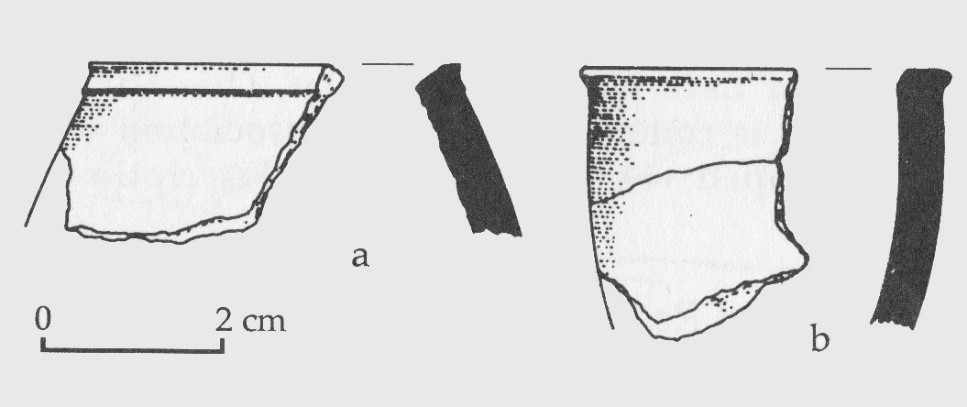 Figure 8.12 – Site E-94-2 Red Ware bowl rims
(Source: Nelson 2002, p.36, figure 3.19)
Craft skills
There is no evidence for basketry, matting, rope, textiles, or leather goods, although these must have been present as it is difficult to imagine that life would have been possible without them (Hurcombe 2014). All the raw materials would have been available in the form of the trees and shrubs that have been noted at Nabta in the Ru’at el-Baqar archaeological remains, particularly the drought-tolerant Acacia, Tamarix and Panicum turgidum species, which today provide fibre for matting, rope and related goods (Mahmoud 2010; Springuel 2006). Tannins from Acacia nilotica could have been used for tanning leather, as it is today (Springuel 2006).
At E-75-8 three pieces of worked bone were found, including two projectile points (see figure 8.9-h and i) and one awl, all burned, as well as the fragment of another bone point that was 10mm long and 3mm wide at its widest diameter and was polished all over (Close 2001, p.381). These suggest that a bone tool industry might be under-represented in the archaeological record.
Ostrich eggshell beads are still found and although they are much less frequent than in the Ru’at el-Ghanam Middle Neolithic, there are no other observable differences. They were made by perforating an unshaped piece, which was then chipped into roughly circular disks, to a mean diameter of c.6.2mm, before being polished (Close 2001, p.379-381).
Structures
Tumuli, complex structures and so-called megalithic alignments were all constructed from Nubian Formation sandstone that was quarried locally. General stone-working skills were required in their shaping and erection, and labour would have been required to move and position the larger components of the megalithic alignments, as discussed in Social Assets.
Food storage systems
Other than livestock used as storage on the hoof, the only signs of food storage systems are at E-75-8 where a possible hut was associated with two pits of undetermined function. Given the short-term occupation of the site and the fairly sparse vegetation predicted for the area at this time, it seems likely that there was not sufficient wild plant food to merit storage.
Transport
It is possible that cattle, sheep or goat were used as pack animals (figure 8.13). Walking was also a perfectly viable means of transporting items that were lightweight and could be strapped to the body, carried or dragged. Some heavy items, like mortars, were left in situ.
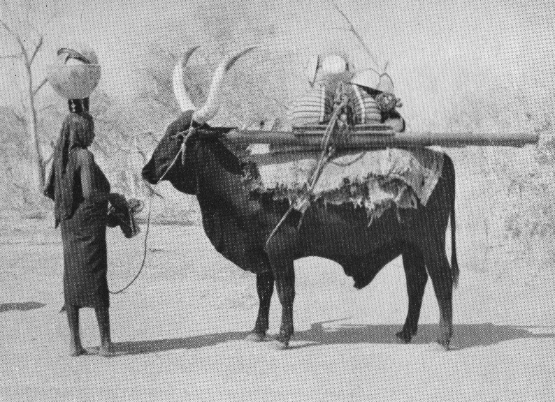 Figure 8.13 – Fulani woman moving camp in the dry season
prior to a 28km walk (Source: Stenning 1959, p. ii, plate 1)
Fuel
Given the available wild and domesticated fauna, dung should have been readily available, particularly concentrated beneath trees that would have provided shelter (Butler 2002, p.181-2; Evans-Pritchard 1940, p.258; Hassan 1988; Hobbs 1989, p.90, p.104-6; Linseele et al 2010).
Wood was a relatively scarce resource that was not readily renewable. It would have been a high-risk strategy for the long term security of the environment, as recognized by pastoralists, who enforce strictly encoded social and religious prohibitions established to protect living trees (Bollig 2006, p.336-7; Harir 1996; Hobbs 1989, p.53; Hobbs et al 2014; Krzywinski et al 1996; Simpson 1992; Wendrich 2007, p.74). However, in Nabta the number of Late Neolithic hearths containing plenty of wood charcoal suggest that either dead wood was being used in order to protect live trees, that there were mechanisms in place for ensuring that the host tree was left intact, or that wood was not considered to be in danger of being over-exploited. All of the woods that were present at Nabta would have been suitable for fuel, particularly Acacia ehrenbergiana which has a relatively low moisture content and burns very slowly, providing heat over long periods (Belal et al 2009, p.70-71; Springuel 2006, p.4).
Craft infrastructure
No kilns or equipment associated with pottery manufacture are found at Nabta. In so far as lithics are concerned, debitage occurs around hearths, so tool manufacture was not isolated from living areas. There is no evidence of specialized craft production areas.
8.3.1.3 Social Assets
Status, roles and social organization
Wendorf and Schild believe that during the Ru’at el-Baqar the creation of the tumuli, their contents and the stone circle would have required a considerable level of social organization, backed by a degree of social complexity embedded in religious or political authority (Wendorf and Schild 2001 p.9). The act of materializing ideas as structures indicates a fundamental need to act upon beliefs, and to co-ordinate ideas about how these conceptualizations should be translated into ceremonial structures. Whether or not this required leadership, implementation would certainly require discussion, agreement and teamwork. Symbols of power of the sort discussed by MacDonald for the Pokot of Ghana (MacDonald 1998) and di Lernia for the Messak Plateau (di Lernia 2013) are completely absent. For example, there is no evidence of religious paraphernalia, individualized symbols of power, luxury goods, or burial of elders.
In pastoral societies status is often conferred by hereditary systems but may also be embedded in perceived wisdom, experience, craft skills, negotiating skills, healing or spiritual mediation, or other valued characteristics (Klima 1970; Manger et al 1996; Niamir 1991; Olupona 2014, p.40; Schareika 2014, p.4; Smith, A.B. 1996, p.30). As researchers in both ethnographic and archaeological fields have demonstrated, socially stratified societies and pastoral livelihoods are fully compatible (Dika Godana 2016; Honeychurch 2014; MacDonald 1998; Robertshaw 1999) but may take a variety of forms, often including fluid arrangements whereby leadership is earned on an ongoing basis (e.g. Wengrow and Graeber 2015 p.603-4) or when leadership for a specific task is required. Layton et al suggest that nomadic pastoralist mobility and the inherent risks involved lead to mainly egalitarian communities (Layton et al 1991, p. 258) but it is by no means clear that Nabta pastoralists were fully nomadic.
An alternative model, given the presence of processes and activities that required the organization of both ideas and labour, is one of heterarchical organization, which is defined by Crumley as “the relation of elements to one another when they are unranked in a number of different ways” (1995, p.3). Whilst status may exist, the nature of power, and the people with whom it lies, may shift and change due to changing circumstances and inputs (Klima 1970, p.87). In such a scheme short-lived leadership could be acquired on the basis of skills and abilities that are suitable for specific tasks, but may be fluid depending on the season or needs of the community on a temporal or geographical basis. If the Nabta pastoral and hunting groups were seasonal offshoots of a larger transhumant community, the arrangement of authority and roles is likely to have been extremely flexible, based on discussion, the pooling of ideas and the availability of skills of certain members of society “for bringing together different points of view into some imaginative synthesis that stretches beyond parochial interests” (Spencer 1998, p.249). This does not argue against social complexity but does favour a range of possible models for organizing people. As Wengrow and Graeber observe, “It is simply not possible to have an evolutionary progression such as ‘band’ – ‘tribe’ – ‘chiefdom’ – ‘state’ if your starting point is a society that moves effortlessly between institutions” (Wengrow and Graeber 2015, p.608). As there are no obvious signs of social stratification it maybe that individual projects were organized on an ad hoc basis by whoever was most qualified at the time. That is not to suggest that such leadership roles would be allocated informally; it is entirely possible that such agreements and allocations of status were highly formalized. More permanent leadership roles would be expected where potential conflict over pasture and water sources might arise, that might leave a more definitive archaeaologicl signature (Bardhan and Ray 2008; Bollig 2006, p.325-339; Dasgupta and Heal 1979; DFID 2000a; Ostrom 2008; Tiffen 1996; Vivelo 1977, p.15) but there is no indication of that at Nabta.
Woods discusses the ceremonial centre in terms of religious authority (Woods 2016, p.176-199). Her interpretation, like that of Wendorf and Schild, focuses on the location of the ceremonial centre on the edge of a major drainage wadi, “the focal point for rituals to the supernatural entities responsible for rain” (Woods 2016, p.188). She suggests that there may have been a rainmaker bridging between the physical and non-physical and overseeing rain-making rituals at Nabta, in a period characterized by unpredictable rainfall (2016, p.84-4, p.194-5). Rain-making rituals are not uncommon in ethnographic data (e.g. Lienhardt 1961, p.85, 92-93, 101) but the evidence for such an individual is nebulous. The individual buried in E-97-5 was a young male (Applegate et al 2001, p.477-478) but he was unaccompanied by grave goods or personal ornamentation and there is no indication that he had any specific status.
The presence of pottery of identifiable and consistent appearance and raw materials suggests that there were individuals who inherited the knowledge of pottery manufacture, were themselves in a position to communicate knowledge and respond to economic drivers. There are no indications, however, that this was a centralized industry.
Ideology and Religion
A number of sites at Nabta may have incorporated ideas about religion and spiritualism including a set of 15 tumuli within a wadi that is the drainage of rainwaters into the Nabta basin (Schild and Wendorf 2012 p.422), the small stone circle E-92-9 at the end of the valley (Applegate and Zedeño 2001; Schild and Wendorf 2015; Wendorf and Schild 2001c, p.668), the so-called “complex structure” E-96-1A (Wendorf and Królik 2001b; Wendorf and Schild 2001c, p.669-670) and two megalithic alignments named Group A and Group C (Wendorf and Królik 2001a; Wendorf and Malville 2001).
The tumuli are all concentrated on the northwestern edge of the main basin, where playa silts, a large phytogenic dune and sandstone bedrock are all present. All are built of broken sandstone blocks, placed along the west bank of a wadi that flowed into the Nabta basin. Of the fifteen identified, 9 have been excavated. They are often located on prominent geomorphological features, like the top of a dune, on the edge of a bedrock outcrop or a knoll, although E-97-6 was built in a small hollow between knolls and the early Late Neolithic site E-94-1N was built directly within the playa (Applegate et al 2001, p.468). Each is about 3-5m in diameter, composed of unshaped and roughly shaped sandstone blocks to form a dome shape in some cases. Height is only given in one case, and this is 85cm at E-97-12 (Applegate et al 2001, p.479). Stone counts are not given for most of the tumuli but E-97-5, the human burial, was topped with around 100 slabs, E-96-2 had only eighteen, and E-97-4 had gaps in the tumulus stone and appeared to be incomplete and included tethering stones amongst the tumulus stones (Applegate et al 2001, p.475). Although usually divided into two categories (animal and human) there are arguably six types of tumulus based on contents (data assembled from Applegate et al 2001):
- An articulated young female cow laid on its left side in a backfilled pit (figure 8.14) over which was a tumulus in which sheep/goat or Dorcas gazelle bones were scattered in the stone (the articulated cow and pit are unique to E-94-1N)
- Tumuli with cattle bones scattered into the stones of the tumuli (E-97-4 and E-97-16)
- Tumuli with mixed cattle and sheep/goat bones scattered into the stones (E-94-1S and E-97-6)
- Tumulus with mixed cattle bones and canine (E-96-4)
- A human burial without a cranium, mandible, teeth and the majority of scapulae (E-97-5) (figure 8.14)
- Empty tumuli (E-96-2 and E-97-12)
The remains of individual cattle in the tumuli containing only disarticulated cow (figure 8.14) remains varied from one to four, totalling a maximum of nine individuals, comprising two juveniles, 4 sub-adults, 4 young adults and 1 possibly elder example, the latter an exception. The total number of sheep/goat represented are three. Artefacts were found in the stones of some of the tumuli, but amounted to a maximum of two in a tumulus (Applegate et al 2001). The disarticulated remains appear to have been butchered prior to being deposited, apparently at random, among the stones of the tumuli, and the animal bones appear to have been added throughout the construction of the tumuli. Gautier suggests that the cattle tumuli may have been used repeatedly with each animal representing one event (Applegate et al 2001, p.483). The poorly preserved human burial in E-97-5 (figure 8.14) was located on a white bedrock knoll in a tumulus composed of less than 100 sandstone slabs. The single adult is semi-articulated and flexed on its right side, spine to the east and head to the north. The cranium, mandible, teeth and major scapulae are missing, suggesting that the body was either incomplete at the time of deposition or that the components were removed later. Analysis indicates that the remains belong to a young and healthy male, 1.70m tall (Applegate et al 2001, p.477-478). Without excavation of the other six tumuli it is impossible to draw any general conclusions about the tumuli contents. The area around the tumuli consists of uncharacteristic small dispersed individually or in small groups around the tumuli” (Applegate et al 2001, p.468) perhaps implying that the area was reserved for specific socially important activities. Applegate et al 2001, describe them as “shrines” (p.487).
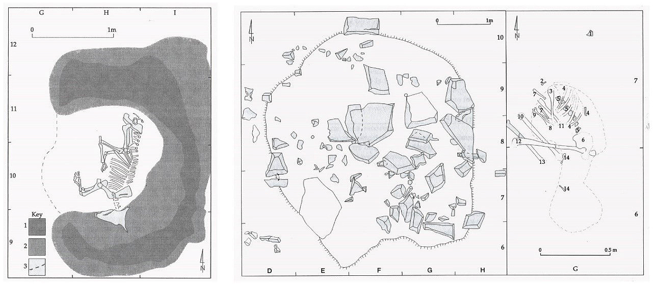 Figure 8.14 – Plan views of tumuli E91-1N, the articulated cow burial and E-97-5,
the human burial (Applegate et al 2001, p.470, figure 15.1 and page 477, p.15.6)
At the end of the wadi was a small stone circle on top of a small sandy knoll that the excavators concluded was a ceremonial circle, site E-92-9 (Schild and Wendorf 2001a; Applegate and Zedeño 2001), shown in figure 8.15 and 8.16:
 Figure 8.15 – Site E-92-9. Stone Circle (Schild and Wendorf 2001a, p.37, figure 2.27)
The stone circle consists of pairs of narrow upright slabs, two lines of sights, one north to south, which parallels the line of the tumuli to the north and megalithic alignments to the south, and one of which points approximately to the place where the sun rose at the summer solstice at the start of the rainy season some 6000 years ago (Applegate and Zedeño 2001; Malville et al 1998). The 55 Nubia sandstone slabs range in height from 20cm to 70cm and do not exceed 20cm in width and 10cm in depth and enclosed an area of 49m2 (Applegate and Zedeño 2001; Schild and Wendorf 2001b, p.37). The arrangement was re-interpreted during work carried out to move the circle to the protection of the Nubia Museum in Aswan, and a ring of slabs has been proposed (Wendorf and Schild 2015, p. 366-367). Malville et al 1998 emphasize the proximity of Nabta to the Tropic of Cancer at this latitude, where the sun achieves its zenith on two days, approximately three weeks before and after the summer solstice: “Vertical structures cast no shadows under the zenith of the sun and within the tropics the day of the zenith sun is often regarded as a significant event” (Malville et al 2008, p.490). The four pairs of gates form two distinct axes, one of which marks the position of the rising sun at the summer solstice at c.6000 years ago (Applegate and Zedeño 2001, p.466). Malville et al say that “No evidence of astronomical orientations has been reported, and none is readily discernable in photographs of the circle” (Malville et al 2007, p.3).
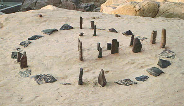 Figure 8.16 – The E-92-9 stone circle (3.6m diameter)
(Schild and Wendorf 2015, p.367, figure 24)
Complex Structure A has been placed in the Ru’at el-Baqar at c.4800BC – a calendrical not a radiocarbon measurement (Wendorf and Królik 2001, p.520) whilst the others excavated to date, around 30 in total, belong to the Bunat al Ansam Final Neolithic (Wendorf and Królik 2001). E-96-1A consists of roughly shaped and unshaped rocks that look very much like bedrock. There are no traces of animal or human remains. Alignment Group A ends in Complex Structure A, also called E-96-1A, which lies c.200m to the south of E-95-8 (Wendorf and Królik 2001b, p.490). It is one of a number of similar structures known as “complex structures” (collectively E-96-1), consisting of upright and horizontal stones arranged in an oval with between one and three larger stones at the centre constructed over tablerocks some 2-4m below the play clays and silts, and all located away from settlement areas (Wendorf and Królik 2001). There are no traces of animal or human remains. Of all the structures in the ceremonial centre, these required the most labour. Just digging down to the tablerocks would have required considerable effort. It is not known how the tablerocks (figure 8.17-1) were located but once they were reached, they were usually deliberately shaped. Sections had been removed from the tablerock in Complex Structure A to create a curved surface. In the case of Complex Structure E-96-1A, a quartzitic sandstone block greater than three tons was placed 50cm above the tablerock and 80cm below the surface and was shaped and smoothed, with one convex side pecked smooth and a projection at one end, set upright, with the projection slightly west of north and held in place by two large slabs (figure 8.17-5). Although it is usually referred to as cow-shaped, the authors originally commented that “it could represent almost anything” (Wendorf and Królik 2001b, p.510). The pit was then refilled to surface level and an oval of 71 tightly packed quartzitic sandstone uprights was erected over the top, with a diameter of 5m x 4m, with three partially shaped slabs in the centre. That they were important is clear from the investment of time and energy that went into building them but it is impossible to choose between the various functions proposed for them (Wendorf and Królik 2001, p.510).
 Figure 8.17 – Site E-96-1 Complex Structure A showing : 1, the tablerock;
2, cemented sand with small rock slabs; 3, playa silt; 4, silt backfill inside pit;
5, sculptured stone; 6, laminated sand and silt; 7, surface stones
(Wendorf and Królik 2001 p.509, figure 17.8)
Megalithic alignments radiate outward from Complex Structure A. Those that appear to belong to the Late Neolithic are Group A (figure 8.18) and Group C, dated on the basis of the stars towards which they were aligned (Wendorf and Malville 2001, p.502). The alignments in Group A1, A2 and A3 point towards the rising of Dubhe. Alignment C extends towards the rising of the star Sirius. There is an estimated 80 years between alignments C1 and A1, and the alignments A1, A2 and A3 appear to represent adjustments over time to the rising of the circumpolar star Dubhe (Wendorf and Malville 2001, p.500-501). All the alignments were built of quartzitic sandstone, which could be sourced locally. Stones were either roughly shaped or unshaped, and many were fractured. Group A consists of clusters of stones, aligned roughly north to south, located c.100m southeast of E-91-1 (Wendorf and Malville 2001): “The entire group represents three sub-alignments, all with lines of site converging on the largest of the Complex Structures located about a km to the southwest” (Wendorf and Malville 2001, p.490). Alignment Group A1 is formed by A-6 to A-10 and Complex Structure A. Each consists of groups of fractured stones, some of which have been successfully refitted and although now may consist of up to seven blocks were probably only one or two large blocks originally. A-10 is still vertical, its base deeply embedded, and probably stood about 1m above the surface at the time of its construction (Wendorf and Malville 2001, p.493). Its azimuth orients it to the rising position of circumpolar star Dubhe, the largest star of the Big Dipper, at a date of c.4742BC (Malville et al 2008; Wendorf and Malville 2001, p.500), which pointed to the north celestial pole when no Pole Star was visible for navigation (Malville 2009, p.14). Alignment C, consisting of C1 to C7, was aligned towards Sirius, and refitting suggests that blocks reached a maximum height of around 2m, and a width of 1.5-2m, and were substantial constructions. Sirius is the brightest star in the night sky and rose after a 70 day absence just ahead of the sun between 27th and 30th May and would have been clearly visible throughout June and July at 4820BC±50 (Malville et al 2008; Wendorf and Malville 2001, p.500). Wendorf and Malville state that “[T]he rising stars of Sirius in the dawn, coupled with the northernmost excursion of the sun at summer solstice, may have been viewed as harbingers of the summer rains” (2001, p.500).
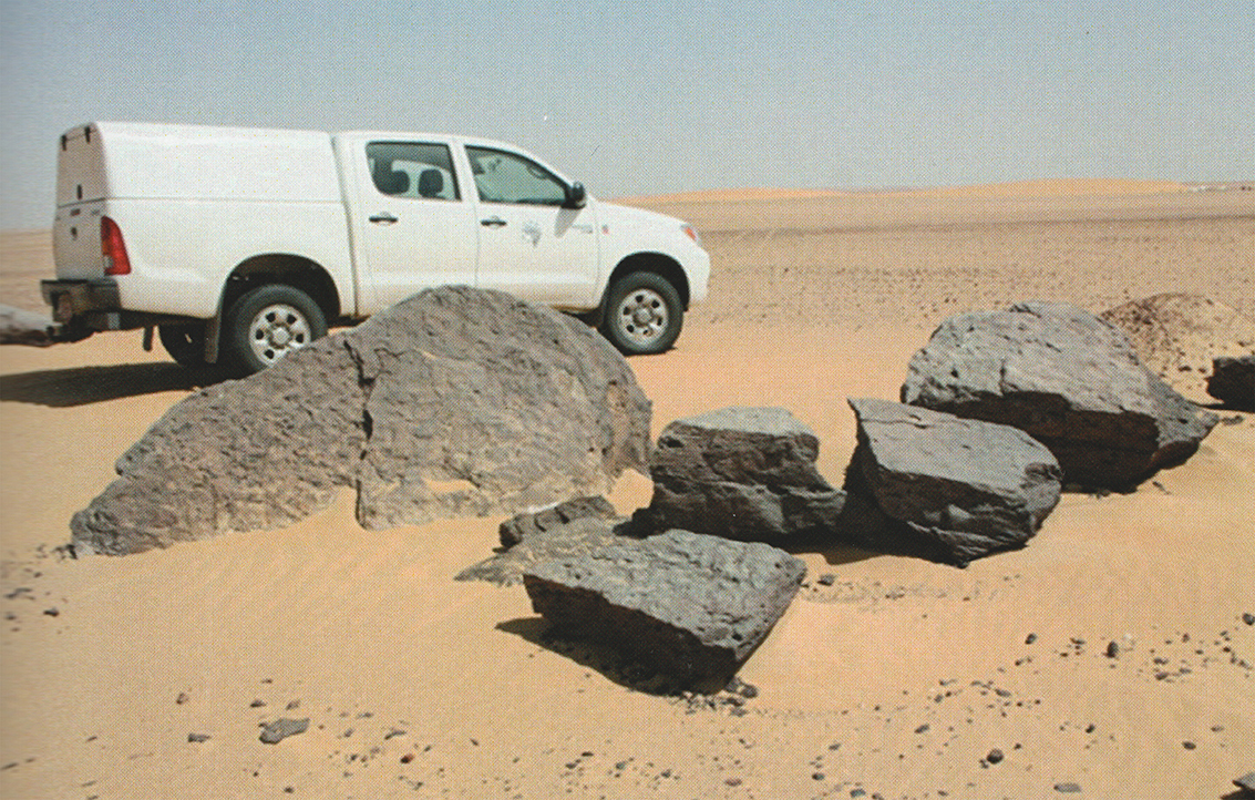 Figure 8.18 – Alignment A, Megalith A-2. Tilted and collapsed, originally composed
of four upright stelae (Schild and Wendorf 2015, figure 9)
Astronomical knowledge is usual amongst pastoralists. The Woɗaaɓe, for example, act upon the knowledge that when the Pleiades and Orion are set, rains are imminent (Schareika 2003, p.38), and use lunar cycles to time movements to new pastures, maintaining a strict system of moving camps every 2-3 days and moving out of an area every week (Niamir 1991, p.4). In purely functional terms it would not have been necessary to provide a marker to point to the solstice or the stars because such knowledge would have been fundamental. Marking them would not have been about locating them. Instead, the importance of the structure may have been focused on a) incorporating the solar and stellar features into the inhabited environment, b) activities related to renewal of rainfall or similar interests, and c) its actual functions, which may have been multiple, capable of acting as a predictive tool for weather, a scheduling tool for movement, a celebration of the predictable in a stochastic world, an interface to a religious mythology associated with celestial body or a trigger for certain rites of passage. It may also have been a signal of territorial affiliation, communicating the presence of a certain ethnic identity or allegiance.
Whatever its exact purpose, the ceremonial centre seems to have become invested with meaning beyond its value for subsistence. Sapignoli (2014, p.48) says that “virtually all small-scale and middle-range societies have strong locality ties. That is, they have a common territory or area to which they feel a strong connection” whilst Frederick (2014) observes that some sites that are used in a seasonally mobile routine have associations that reinforce identity, ideas and social stability. Above all, the ceremonial elements seem to materialize a concept of place, in the sense of Tilley when he says that identifying with place “requires work, repeated acts which establish relations between peoples and places” (2006, p.14). Tilley’s view that “self-identity and social identity are bound up with the contingencies and uncertainties of the present and that non-verbal forms of expression are an essential part of that process” (2006, p.16) seem to fit well with the different elements of the ceremonial centre and the need to negotiate and re-negotiate different aspects of the landscape under conditions of variability and vulnerability through time.
The subject of time is raised by Olupona (2014, p.6), who points out that many indigenous African religions have a combination of linear and cyclical time. Bell and Walker (2005, p.11) who also point out that whilst cyclical time (such as repeated daily activities and movements of celestial bodies) may be the usual way of experiencing time, linear time may be marked by unusual events, disasters, and specific memories. It is often difficult to detect an awareness of linear time archaeologically (i.e. one-off events in history or prehistory) but Nabta provides two examples: sequential construction events and repeated depositions of animal and human remains. Nabta also demonstrates an awareness of cyclical time (astronomical observation, re-use of the ceremonial centre for burial events). Crandall (1998, p.109-11) discusses Himba concepts of time in Namibia, where gods live in an eternal realm and humans live within a fragmented, transient temporal scale that is quite different. These may be represented at Nabta by the enduring character of the ceremonial stone structures and the ephemeral nature of th settlements. As Whittle discusses (2003, p.105) time also encompasses ideas of memory and times past: “looking back is a central part of the identities of people.” Again, experience takes place at different scalar levels at Nabta: that of conceptualization followed by erection of monuments and then the repeated actions that take place in relation to it, reinforcing certain memories at the expense of others, but not constraining them. Memories, like Chinese whispers, mutate. Nabta is a “persistent place” (Schlanger 1992; Shiner 2009), attracting visitors for thousands of years. Certainly the surface scatters of previous occupations will have given a sense of both continuity and change, as different cultural materials made up the living landscape, and with each generation the earlier ceremonial components may have entered the realms of myth and oral (Whittle 2003, p.124; Kavari and Bleckmann 2009).
It is important not to overstate the size and number of components that existed at any one time. The stone circle, the varied contents of the tumuli, and the addition of one Complex Structure and two megalithic alignments were not a preconceived design, but something that evolved, building upon original conceptual ideas with new ones. Barratt (1994, p.13) argues against complexes of this sort being the outcome of “a planned intention” and instead suggests that architectural components “should be viewed as a series of localized spaces, created as ongoing projects by builders who rarely glimpsed the totality of their creation” (p.14). Whilst there are running themes throughout the ceremonial centre that indicate a unified conceptual scheme it was not known what the conceptualization was, but it was sufficiently valuable to be elaborated over time. In other words, there was a demand that the constituents of the ceremonial centre supplied.
Wendorf and Schild see developments in the Late Neolithic as the emergence of the “African Cattle Complex”, in which cattle serve to symbolize status and power (Wendorf and Schild 1998, p.113). However, the tumuli, with mixed cattle, sheep, goat and, in one case a canine, do not seem to amount to strong evidence for a cattle cult, a concept introduced by Herskovits in 1926 and discussed exhaustively ever since. There are no direct analogues between the burials at Nabta and the complex burials in the Sudan. In Sudanese cemeteries bucrania were found buried with human interments (Chaix et al 2012; Paris 2000; Reinold 2001, p.2-10; Schild and Wendorf 2001, p.16-17; Wengrow et al 2014), and cattle were also important in central Saharan mid-Holocene contexts, where cattle burials have been found (di Lernia 2006). A number of writers have recently discussed the importance of relationships of herders with their livestock (Dittrich 2017; Honeychurch and Makar 2016, p.350-351; Oma 2010; Orton 2010; Russell 2010; Sykes 2014) and emphasize how there is often not a clear delineation between human and animal members of the community. Whatever symbolic role cattle may have had during the Ru’at el-Baqar at Nabta, they should not be isolated from goat, sheep, canine and human, which are also represented in some of the tumuli.
Woods, conflating the Ru’at el-Baqar and the Bunat el-Ansam Final Neolithic, believes that wadis were “places of potency and power since they were channels for run-off of the life-giving rains as a result of rains” (2016, p.188) and interprets the ceremonial components as rituals centred on wadis relating to supernatural forces when rains failed, as they must have done during the mid-Holocene, overseen by a special rainmaker (2016, p.194). This echoes Wendorf and Schild who say that the wadi was “an ideal place to bribe the gods and beg for rains” (Wendorf and Schild 2004, p.12). Woods describes a conceptual worldview incorporated into the ceremonial centre, “a three-tiered cosmos: the heavens, the earth and the underworld represented by the pits under the complex structures” with the carved stone in the shape of a cow perhaps representing “a shamanic rain animal” employed by the shaman in rainmaking rituals (2016, p.194-5). Given the lack of any concrete evidence for any shamanic activity at Nabta and the lack of any data about the economic dependency of groups on Nabta, I prefer a more abstract interpretation that accepts the importance of the different components without attempting to nail a specific religious framework or function to them.
With elements repeated but not duplicated, the ceremonial components seem to have formed a narrative over time. It could be the perfect illustration of Tilley’s belief that places “are in flux rather than static nodes or points in a landscape” (Tilley 2006, p.21).
Ritual and rites of passage
At Nabta the only signs of ritual activity are the deposition of animal and human remains within the tumuli described above. As discussed above, construction and ongoing ritual activity exist within two separate types of time: linear (the construction of the monument as a fixed point in space and time) and ongoing (where the place is fixed but the activity is repeated and possibly cyclical). At the same time it is embedded in memory, which may have been described in myth or other oral history (Whittle 2003, p.124; Kavari and Blecmkan 2009).
Except in the case of the articulated young cow found at E-94-1S, animal remains are disarticulated and scattered throughout tumulus components (e.g. sites E-97-4, E-97-16, E-94-1S, E-97-6 and E-96-4), perhaps in series of repeated events, each tumulus growing as new animal remains were added. The human remains in E-97-5 were in poor condition but it is certain that some skeletal components were missing, either lost before deposition, deliberately excluded, or removed after burial, leaving open the possibility that specific ritual activities surrounded the treatment of the young male with the tumulus. Whittle emphasizes that “an important element of creativity in the renewal of tradition” may be a part of how rituals were enacted (2003, p.124), and this might account for the differences in how the tumuli were used and what was deposited within them. The deposition of bones that had apparently been butchered prior to burial, suggests that some sort of socially motivated activity, such as group sharing of meat, or ritual offerings may have taken place prior to deposition. Important occasions like rites of passage or sacrifices to deities might merit the killing of an animal, which represents a loss of resources, including milk, blood, meat and reproductive value. Russell (1988, p.74) calculates that cattle provided over 3½ times more calories than sheep and over 4½ more than goat, indicating even when assessed in purely economic terms, the slaughter of cattle is a considerable act of sacrifice.
Wendorf and Malville suggest that the various components making up the ceremonial centre “may have been motivated, in part, by the diminishing availability of water at Nabta and a consequent attention to rainmaking rituals” (2001, p.502). Beyond the contents of the tumuli, any evidence for rituals no longer remains. Stone, however, remains the dominant feature, acting as a durable bridge between the people, the local landscape, including the sky, and beliefs and seem to serve much in the same way as Renfrew’s “attention focusing devices” (Renfrew 1994, p.51-2).
Tradition and social values
The main theme of the Ru’at el-Baqar is a break from previous traditions in the Nabta area and the establishment of distinctive new material output. The idea that objects are involved in communication and social reproduction means that they are often connected to ideas of social change and new ideas, and may reflect major decisions about livelihood strategies (Sørensen 1999, p.185). In the Ru’at el-Baqar there is a remarkable change in form of ceramic material expression. There is no sign of an enforcing hierarchy imposing values, so any form of communication of identity and kinship affiliation is presumably either isochrestic, sensu Sackett (1986), or stylistically comparative, sensu Wiessner (1984). Sackett’s isochrestic concept is a form of transmitting social relations unconsciously, whereas Wiessner’s stylistic comparison is far more deliberate, a way of negotiating and creating identity and relationships. Hassan emphasizes that people “tend to cling to the paradigms, values and institutions that have proved to be successful in their own past . . . As a result they are reluctant to undertake corrective actions that go against their social grain” (Hassan 2008, p.41-2). If Garcea and Hildebrand are correct in thinking that Saharan pottery from the early and mid-Holocene acted as “significant cultural markers” (Garcea and Hildebrand 2009, p.310) then the distinctive design of the black-topped ceramics and red wares may be indicative of a broad set of shared values and attitudes, as well as a shared knowledge and skillset amongst craft specialists, together with a rejection of earlier ideas and traditions in favour of new ideologies and concepts. The need to diversify livelihood strategy may have involved experimentation with new areas and the establishment of new contacts. Nelson and Khalifa speculate that greater interaction would have been necessary between groups and that these new spheres of interaction might have led to cultural exchange, eventually leading to the “melding of cultures” as mobility became increasingly constrained (2010, p.140), consistent with Sam and Berry’s observation that increasing interdependence and some assimilation, potentially involving psychological stresses, could lead to cultural responses (Sam and Berry 2010, p.474)
Gatto discusses the implications of “fluidity of group affiliation in boundary areas” and sees the desert and Nile as a nuanced continuum between the Nile and the nearby deserts (Gatto 2009, p.127). Although she is discussing later phases, corresponding to the Final Neolithic onwards, her comments seem to be just as valid for Nabta in the Ru’at el-Baqar. Crumley’s research has shown that in frontier situations there may be multiple boundaries crosscutting each other including social, linguistic, topographic, climatic, administrative and commercial elements, forming a “complex dynamic system” (Crumley 1995, p.2). As Gatto suggests (2009, p.127) the work of Lightfoot and Martinez (1995) is valuable in this context. They suggest that frontiers are “socially charged places where innovative cultural constructs are created and transformed” involving processes of creolization or syncretization (Lightfoot and Martinez 1995, p.472). In the Ru’at el-Baqar Nabta there are four potential frontier-type situations. First, whereas Nabta lies in modern Egypt, it is very near the modern Sudanese border and has more in common with the archaeology of northeast Sudan or Nubia than it does with northern Egypt (Edwards 2004; Gatto 2011; Gatto and Hildebrand 2009), although Nabta is often discussed as a phenomenon contributing to later Egyptian soci-economic development (e.g. Wendorf and Schild 2004). The second scenario focuses on the Nile. Even though Nabta is only a couple of days walk from the river there may have been a perceptual dichotomy between desert and Nile not unlike the Pharaonic period’s mythological distinction between the black land of the Nile floodplain and the red land of the deserts (Sidebotham et al 2008, p.21). Whilst there is a third boundary, the natural granite barrier across the Nile at Aswan called the First Cataract, this was only really relevant if water transport was an important factor at the time, which it does not appear to have been. Model boats only appear from the later Badarian (Brunton 1928, p.34; 1937, p.7, 57) and there is no other evidence of water transport in this period. A fourth, and perhaps more realistic type of barrier is each group’s own identity, expressed via material culture, which would have had to be negotiated between groups in a number of ways. As Klima points out in his discussion of the new knowledge brought in and implemented amongst the Barabaig by exogamous marriages, adoption of new ideas does not necessarily challenge group or kinship identity (Klima 1970) but can reinforce the strength of a group’s risk-handling abilities.
As environmental conditions influenced and constrained patterns of movement for all groups using the Western Desert as a resource, people will have circled more closely together. What was happening at Nabta Playa may well be explained by a blending of different traditions, where new ceramics are a component of a revised way of thinking, an outlook that incorporated new conceptualizations of the material world to establish a new and mutually compatible approach to living.
Material articulation
The new ceramic types may be seen as “objects of thought” (Edmonds 1995, p.41), a deliberate response to aspects of economic life, movement through the landscape, stochastic weather conditions, negotiated relationships with Nile valley inhabitants and the cascade of new decisions that these implied. Wobst (2000, p.47) suggests that uniformity of design is a way of reinforcing ideas and routines that are under threat – an act of social interference to preserve certain conditions. In the case of Nabta what began as a way of reinforcing a new way of negotiating between tradition and innovation may have become a way of reinforcing identity over generations, particularly in the face of environmental deterioration.
The ceremonial centre also represents the materialization of concepts. Building on the work of Barratt, Richards focuses on stone circles, in particular, as a negotiated outcome leading to “a reaffirming of relations between people” (Barratt 1994, p. 13-23; Richards 2013, p.7-8). Also appropriate is Tilley’s description of landscapes as “systems of signs” that are incorporated into identity and become agents of that identity. The monuments may have been a concrete way of both connecting with the group’s relationship with the Nabta basin. Incorporating ideas of time (linked to appearances of celestial bodies), navigation (a familiarity with the night skies) and space (enclosure or definition of space) there are different types of idea built into the circle. The tumuli closely resemble fragmented outcrops, and the all of the monuments were manufactured from local stones rather than imports. This suggests that either the exact material was unimportant to the purpose of the construction or that the material, being local, was a fundamental part of the conception.
Mobility
Whilst most of this case study focuses on the character of the immediate vicinity of Nabta, and the resources that brought people into that area, the perception held by the people who visited Nabta will have comprised a much larger world of multi-vocal landscape use and understanding, as groups moved between areas along familiar routes, where activities were carried out and memories were formed as part of a process of aggregation and dispersal (Bender 1992, p.735; Bender, Hamilton and Tilley 1997; Honoré 2017; Sheller and Urry 2006, p.210; Whittle 2003, p.43). Helpful in this area is Schareika’s assessment of the Woɗaaɓe of southeastern Niger (2003, p.18), where mobility contributes to an individual’s status as a good manager of herds which is the only means by which stock loans became available. In the Woɗaaɓe’s worldview both animals and men become integrated with the environment “and the rhythm of life exercised therein” (Schareika 2003, p.18). Turton’s analysis of mobility amongst the agro-pastoral peoples of the lower Omo valley (southwest Ethiopia) concludes that it is not just a practical necessity but that it is essential to a sense of self: “the very idea of movement was a defining feature of what it meant to be Bodi, Mursi, Nyangatom, Daasanach etc . . . In a sense they were movement.” (2011, p.165, author’s italics). Amongst the Ababda of Wadi Allaqi where today women are based at a permanent water source to supervise children and small animals and carry out small scale cultivation, men depart to herd livestock because “being at one with the desert” is important to the sense of identity of many of the men (Belal et al 2009, p.131). A similar point was made by Roe (2008) who says that knowledge of the desert confers status on men.
Travelling to Nabta and beyond Nabta may have combined economic activity with the spirit of a pilgrimage, endowing the process of travel with a spiritual component with the route as much as the playa basin containing associations that were unique to that destination (Claassen 2011; Sheller and Urry 2006, p.213). Nabta was a destination that had been materialized both by broadly contemporary site furniture and the development of ceremonial features. Nabta was a place embodied in both the physical and numinous realms of the landscape. This landscape endured but fluctuated and the features at Nabta suggest more than mere adaptation but rather an intention to exert control.
Inter-group relationships
Relationships between Nabta and other areas, presumably mainly to the southeast where material cultural has considerable similarities, are likely. In the Kerma area the mid-Holocene is associated with an intensification of pastoral activity in the 6th Millennium, with settlement sites from Kadruka featuring cattle, followed by sheep and goat and only rare wild remains (Honegger 2014, p.27-28). The spread of the pastoral livelihood strategy could be an indication of links between the two areas, although much more work needs to be done to relate different phases between the two areas, perhaps as a dedicated project. Grandval emphasises that today in Africa mobility relies on a mixture of scouts and extensive social networks for understanding where grasslands are available and what sort of quality they represent (2012, p.3). The maintenance of kinship relationships, the acquisition of marriage partners and the reaffirmation of religious and ideological connections may have made such connections imperative (MacDonald and Hewlett 1999; Whallon 2006). At the same time, the need to negotiate for territory and expand into new areas may have created the “shared visions of space” identified as a concept by Calvo et al (2016), a mutable concept that might undergo change as increasing variability in environmental conditions required land use and territorial boundaries to be negotiated. As groups gradually dispersed from increasingly inhospitable desert areas, some converging along the Nile valley (Hassan 1986, p.71) new ways of mediating relationships and handling resources must have become necessary. The abandonment of a wider regionally relevant symbolic repertoire for a more localized and newly innovated ceramic output could be an indicator of the sort of social mechanism in which “formal and regular relations of mutual accommodation and generalized reciprocity” were established (McIntosh 1993, p.212).
The acquisition of flint has been mentioned, with the closest source 70km to the north, but it is possible that another source was the Kharga or Dakhleh oasis, some 200km away. That there was contact with people from Dakhleh or Kharga is supported by the presence of bifacially worked tools in the Ru’at el-Baqar. There is generally a north-south divide in tool technology, with bifacially worked tools being confined mainly to the north of Egypt (Kuper and Riemer 2013, p.41). The south of Egypt belongs to a different tradition, more closely linked to the Sudan. The presence of bifacial tools in the Nabta assemblage suggests a connection with the contemporary Bashendi B of Dakhleh Oasis or Late Baris of Kharga Oasis.
Freshwater bivalves (Gautier 2001, p.620) reinforce the idea of connections with the Nile, whilst Red Sea conid shell (Gautier 2001, p.620) suggest contacts across the Eastern Desert. Agate and jasper may also have been sourced from the Eastern Desert where they are available (Aston et al 2000). Acquisition expeditions to acquire flint from 70km to the north may have put people into contact with contemporary oasis inhabitants from Kharga and Dakhleh, as suggested by the presence of bifacials in Ru’at el-Baqar assemblages.
Close (1992) has suggested that E-75-8 might be an aggregation site, an idea also proposed by Woods for the ceremonial centre at Nabta (Woods 2016, p.194). Hofman defines an aggregations as “a means of conducting important large-group activities in environments where situation where continuous long-term large-group coexistence is not viable or economically/socially effective,” the purposes of which could include socially impelled activities, information exchange, sourcing of marriage partners and maintenance of group identity (Hofman 1994, p.346-8). Permanent rather than temporary water sources tend to be preferred (Hofman 1994, p.346), so if one were to predict this type of aggregation, the Nile would be a more attractive candidate. However, predictability of resource availability is another factor, as is the apparent importance of the area from a spiritual and ceremonial point of view. If the waters at Nabta were reliable enough to make it a fixed seasonal destination, this would significantly improve the likelihood of aggregation (Hofman 1994, p.351). None of this either supports or eliminates the possibility that Close was right. Although the size of E-75-8 suggests a concentration of people, and the three separate groups of hearths found at E-94-2 (Mohamed 2001, p.412) might suggest a division of groups based on something other than time, the homogenous nature of the lithic and ceramic assemblage and the shortage of exotic materials do not immediately suggest multiple groups converging on Nabta.
Ethnicity
Cultural output is often used to form and renegotiate identities, meaning that cultural output can sometimes be identified as measures of broad ideas of ethnicity in archaeology (Barth 1969; Knapp 2014, p.43) but may also disguise more subtle processes. Díaz-Andreu’s view of ethnicity is as something perceptual and fluid, rather than something embedded in the material (Díaz-Andreu 1998; 2015), a perception based on “identification with one or more broader groups on the basis of perceived cultural differentiation and belief in a common descent” (Díaz-Andreu 2015, p.102). As Díaz-Andreu says (2015, p.102) “people can identify with one or more broader groups . . . multiple ethnic affiliations usually coexist and overlap in the same person.” These larger units of membership may also be subject to challenge and change. How this sort of ethnicity can be identified archaeologically continues to be debated (Bentley 1987; Cribb 1999, p.44-58; Díaz-Andreu 1998; 2015; Knapp 2014; Jenkins 2015; Shennan 1989/1994). The greater understanding of the role of adoption of symbols, trade, exchange and social fluidity (Hodder 1982c, 1982d, 1985, 1990; Kratz and Pido 2000, p.47) indicates that materials are not always unambiguously associated with individual communities but may be more representative of manipulated messages about larger units of membership to which communities belong or with which they associate.
For the mobile pastoralists at Nabta ethnicity may be temporary for the individual and may change in both the short and long term for the community as a whole as conditions change, and particularly if groups are in the habit of forming and reforming and moving through different territories. Social fluidity may exist, and often clearly does (Cliggett 2005; Hobbs 1989; Manger et al 1996) within a larger identification with kinship groups, religious beliefs and other core ideas of identity, belonging and differentiation. A general correspondence between ceramics and animal remains in particular, as well as lithics, suggest a broad ethnic association between Nabta and the Middle Nile (Edwards 2004; Honegger 2014; Midant-Reynes 1002/2000; Nelson and Khalifa 2010; Tassie 2014) but ceremonial elements at Nabta are quite unlike anything elsewhere. If Tilley is correct in thinking that places or landscapes can be viewed as agents that actively produce social identity (2004, p.31), and that social identity “always requires specific concrete material points of reference in the form of landscapes, places, artefacts and other person” (Tilley 2004, p.217) then the ceremonial centre may be part of the process by which the groups that came to Nabta differentiated themselves from other groups within and beyond a broader ethnic grouping, with ideas expressed along a continuum between ethnic and kinship group identities.
8.3.1.4 Subsistence Assets
Data for subsistence activities
Food Production
As I have described in chapter 3, the character of the Western Desert rangelands was becoming increasingly unpredictable throughout the mid-Holocene, with water sources both drying up more rapidly and becoming increasingly saline. This would have provided a challenge to subsistence strategies, and in Nabta there seem to have been a variety of responses, although the data is limited. In the following tables the potential for food production and consumption is examined; in the next section, the mechanisms by which these could have been leveraged is discussed. Tables 8.7, 8.8, 8.9, 8.10 and 8.11 show only samples that have been confidently labelled Ru’at el-Baqar. Those where contexts are unclear have been excluded.
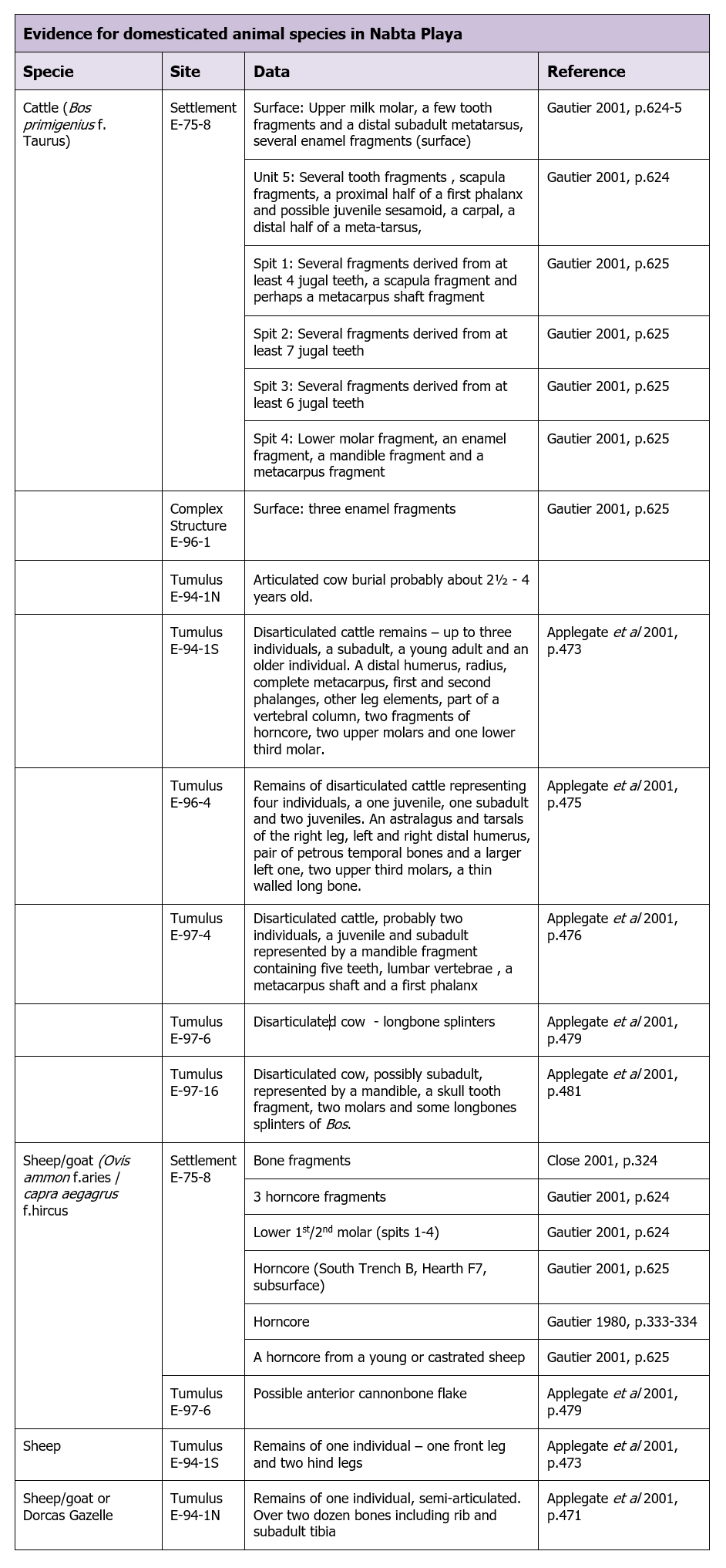 Table 8.7 – Evidence for domesticated animals at Nabta Playa in the Ru’at el Baqar
Hunting and foraging
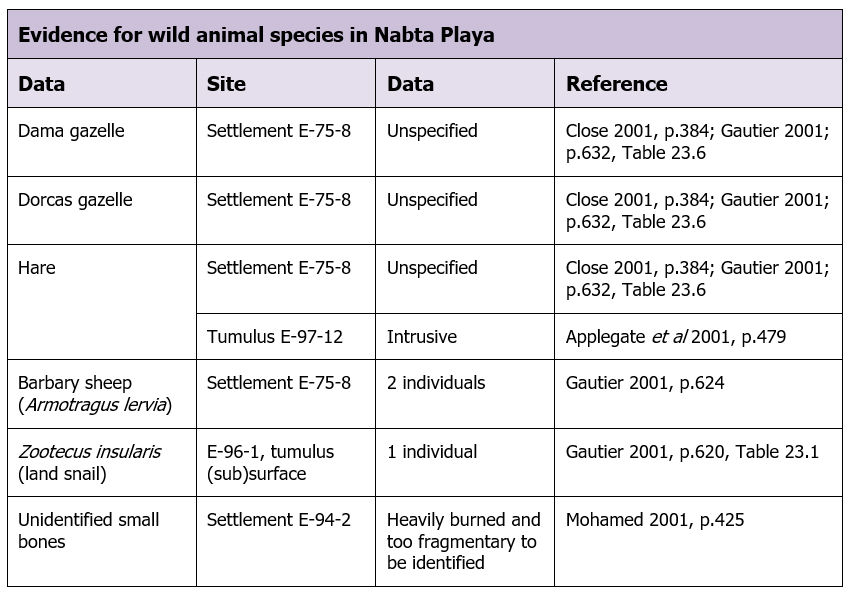 Table 8.8 – Evidence for wild animal species exploited in the Ru’at el-Baqar
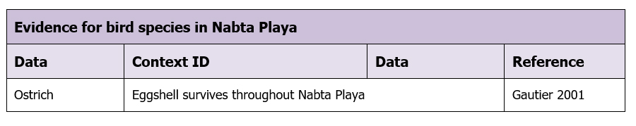 Table 8.9 – Evidence for bird species exploited in the Ru’at el-Baqar
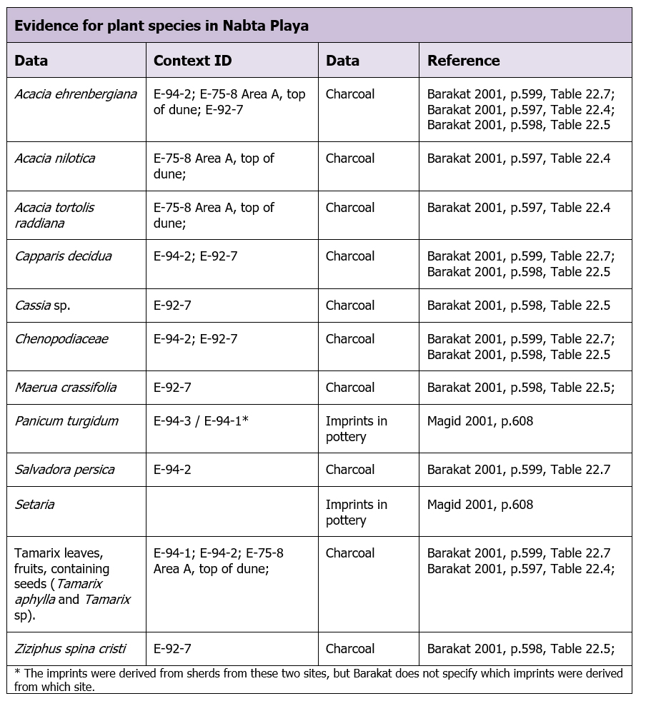 Table 8.10 – Plant species that may have been exploited in the Ru’at el-Baqar
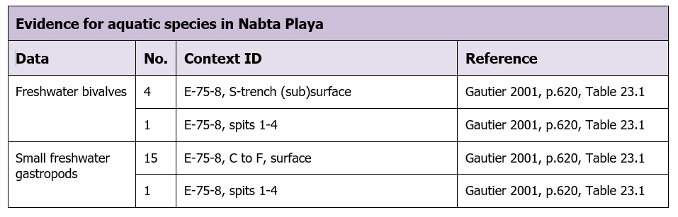 Table 8.11 – Evidence for aquatic species in the Ru’at el-Baqar
The presence of remains of cattle and sheep/goat, together with the presence of tethering stones, are evidence for the presence throughout at least part of the Late Neolithic of herded animals. There has been no question about the domesticated status of sheep/goat and Gautier is confident on the basis of osteometric data from the Nabta tumuli that cattle were “beyond doubt ‘good’ domestic cattle” (Gautier 2001, p.628).
As well as the presumed mixed pasture, there are a number of specific plant species represented at Nabta with properties that are recognized by today’s Eastern Desert Bedouin as excellent animal fodder plants, with fruit, leaves and young branches of all Acacia species, Maerua crassifolia, Panicum turgidum, Crassifolia decidua, Tamarix tortolis and Tamarix nilotica and Ziziphus spina-cristi providing high value nutrition for herbivores (Goodman and Hobbs 1988; Hobbs 1989; Mahmoud 2010; Springuel 2006). Some of the trees, due to their shape, would have been particularly useful for providing shade for herds, particularly the umbrella-shaped tree Acacia tortolis.
Of the wild animal species, all are arid and semi-arid tolerant (Gautier 2001). Bone assemblages indicate that gazelle and hare were dominant, making up 61.1% of the assemblage (with hare at 41.1% and gazelle at 58.9%) (Gautier 2001, Table 23.6 and 23.7, p.632-3), but see Human Assets for how this is measured in dietary terms.
In human burial E-97-17 although no mandible survived, thirteen friable teeth were available for analysis, and these have suggested to Irish (2001, p.523) that the individual was probably an older adult who consumed a large amount of plant foods, the wear being consistent with agricultural diets, and probably the result of eating intensively gathered wild seeds. This is supported by the presence of grinding stones and the admittedly small number of botanical remains (Irish 2001; Magid 2001, p.608). Chenopods may have been used as a subsistence asset. Harlan (1989, p.70) quotes Gast (1968) who describes how Chenopodium vulvaria L. was subject to grazing bans by the Kel Ouilli of Hoggar for two months until wild seeds had matured and could be harvested. Harlan emphasizes the importance of Panicum turgidum, which is the primary grass in the southern Sahara and is still harvested in some areas (Harlan 1989, p.71). A deep-rooted perennial, it can be collected by beating with a stick and is often ground into a form of porridge. As a perennial, Panicum is vulnerable to over-grazing, which can threaten soil stability as its root system forms a loose mesh of stolons.
Practice of subsistence activities
Numerous grinding stones are indicative of the exploitation of plants, particularly seeds. Research by Lucarini (2014b) suggests that in mid-Holocene Farafra oasis, where grinding stones were also present in large numbers, “small and unretouched flakes or blades, probably hand-held and used without being hafted, may have been used to cut a limited amount of plants” (2014, p.366). The wear on teeth from the burial at E-97-17 also supports the proposal that intensive plant collection took place (Irish 2001, p.523). This is given additional support from the plant impressions of drought-resistant Panicum turgidum (Magid 2001, p.608), the grains of which are used by the Tuareg in the central Saharan Ahaggar Mountains in the central Sahara for grinding into a flour to make into porridge (FAO Grasslands Species Projects n.d.). The Sahelian annual Setaria (Magid 2001, p.608), a member of the millet group is also used for making porridge today (FAO Grasslands Species Projects n.d.) and has been found at other Holocene archaeological sites (Garcea and Mercuri 2007, p.97). Both species can be used for human consumption and are valued today as animal fodder (Magid 2001, p.608). The umbrella-shaped tree Acacia tortolis, which is recorded from Ru’at el-Baqar contexts, is known for promoting the growth of palatable grasses beneath its canopies.
According to Edwards and O’Connell (1995, p.772) seeds were probably most important “when groups were closely tied to permanent or near-permanent water sources and entirely dependent on foods available within a day’s round-trip walk” and after the depletion of higher-ranked resources, which would suggest that intensive plant collection would have taken place towards the end of each visit to Nabta, when a pattern of “lower risk foraging” around a plentiful water supply with a wide area of pasture and forage became “higher risk foraging” (Ramsey et al 2016). Edwards and O’Connell estimate that without factoring in travel and search times, it takes between two and seven hours a day to collect and process seeds for just half of the daily calorific intake for a family of five (2005, p.775). Other examples of time-consuming seed gathering are provided by Cliggett (2005, p.4) and Brokensha (1975, p.25). However, there are clearly exceptions. Kuper and Riemer cite the cases of the Tuareg in Mali where one man can gather 50kg of grass seeds in a day, and the MahMahria nomads in northern Darfur where 33 women harvested about 375kg per season (Kuper and Riemer 2013, p.55). Out et al (2016), have found substantial evidence of mid-Holocene plant processing in the mid-Holocene along the Nile in cemeteries R12 (Upper Nubia) and Ghaba (Central Sudan), describing the findings as evidence of “a plant-based economy” (Out et al 2016, p.50).
Cattle are a minority in the bone assemblages, making up 12% of the remains, whilst small livestock represent 27% of Late Neolithic remains. Gautier (2001, p.631) concludes that either cattle herds were never large at this time, or that there was a reluctance to slaughter animals for consumption. In practice small herds produce sufficient milk for small communities and today most herders only maintain large herds for social status and bridewealth (Little and Leslie 1999, p.242; Richerson 2001, p.78; Schareika 2003, p.9) but some still accumulate large numbers as a buffer against risk (Næss and Bårdsen 2013; Richerson 2001, p.78). Research by Dahl and Hjort indicated that only 4-8% of herds were slaughtered each year in modern pastoral groups (1976). This is in keeping with the suggestion by Nelson and Khalifa that most of the vessels found at Nabta were too small and open-mouthed for grain storage purposes and that they may, instead have been used to collect, process and serve milk and blood (Nelson and Khalifa 2010, p.139), although Daniel Miller’s comments about the failure of pottery forms to match functions in at least one ethnographic example should be remembered (Miller 2010, p.47).
It seems likely that livestock stocking rates were heavily influenced by the perceived reliability of Nabta as a source of wet season pasture and water deposits. Although there is insufficient data to inform a firm answer, Campbell et al (2006) suggest that on a continuum between a constant stocking rate (where a low or high constant number of heads of herd is maintained) or a variable/ “tracking” stocking rate (where numbers vary in dry and wet years and are either within ecological carrying capacity or at the level of ecological capacity) constant strategies are followed when tracking rainfall is difficult (Campbell et al 2006, p.76-78, 82). Groups moved away with herds only after digging wells to access the groundwater down to around 2-3m (Kobusiewicz 2003, p.97). The Nile was only a one to three days walk away and plenty of water would have been available when the Nile was reached.
Hunting of arid-adapted species took place, with the evidence of a small number of animal bones supported by the presence of a microliths and bifacial arrowheads, both a minority in the Ru’at el-Baqar assemblage. Preferred species appear to have been gazelle and hare (Gautier 2001). Both were lightweight, with a maximum weight of 75kg, and would have been relatively easy to transport from the point of kill to where it was needed for consumption. Little discrimination was made between male, female, adult or juvenile, suggesting that both gazelle and hare were hunted opportunistically (Gautier 2001, p.632). Heavily burned and fragmentary faunal remains from E-94-2 probably represented small mammals and birds Mohamed (2001, p.425).
Wendorf and Schild (2001c, p.480) suggest that when compared to the Ru’at el-Ghanam Middle Neolithic a shift in raw materials and fewer blades indicate a decline in hunting. Combining hunting, foraging and herding as well as craft manufacture will have required much more skill than exclusively hunting and gathering livelihoods in terms of mobility, scheduling and perhaps territorial negotiations (Dale et al 2004; Marshall and Hildebrand 2002, p.112) leading to new ways of handling subsistence, potentially involving separate parties for herding, hunting, foraging and livestock management both close to settlements and over distances.
The potential for and indications of trade networks
Exchange depends on both demand and a source of supply. Products with the potential for trade locally, between households or groups at Nabta, are domesticated animals, dairy products, ceramics and marriage partners. Objects that might have been exchanged both within groups and between neighbouring groups, like basketry, cordage and leather goods have not been preserved (Hurcombe 2014) but are likely to have capital value.
Where longer distance trade is concerned, direct or indirect, the most obvious line of archaeological investigation is to identify items that could not have been sourced locally, determined by materials or other suitable criteria. Shirai proposes (2006, p.14) that following the diffusion of goats and sheep from the Eastern Desert, there would have been ongoing movements between the Red Sea coast and the Western Desert, with trade and exchange links expanding through time, beginning with Neolithization and developing with the wide dispersal of Red sea shells and other items from the 6th Millennium BC. Whilst freshwater shells from the Nile would have been easy to acquire, the presence of Red Sea shells (Gautier 2001, p.633) suggests either long distance movements or exchange networks. The latter is perhaps a more likely scenario given the specialist knowledge that would be required to acquire the shells and navigate the Eastern Desert.
Hand-made ceramics might have been used for exchange both between households and between groups but there is no sign of specialized or centralized production, and it seems likely that pottery was produced by each group as required, rather than traded, possibly on a household basis (Arnold 1985; Balfet 1965; Needler 1984, p.184; Rice 1987, p.183-91). The expedient character of the lithic toolkit renders it unsuitable for trade. Although flint itself, as a raw material, may have been desirable there are no indications that this was stored at Nabta for export. The presence of bifacials at Nabta, probably originating from Dakhleh or Kharga, gives some support to the idea that these were acquired rather than made at Nabta, but it is not clear what might have been offered in return. Given the lack of any indication of items used in exchange, it seems most probable that any trade and exchange negotiations took place not at Nabta itself but at other places on the seasonal round.
Labour
It is probable that the availability of labour was an important influence on how many livestock were moved at any one time, by either households or by chosen members of the group (Belal et al 2009, p.101; Wendorf and Schild 1980, p.271). The task of moving mixed herds to Nabta will have required healthy and knowledgeable herders and suitable participants for any additional activities that needed to take place. In the quieter periods, raw material acquisition and tool and craft production are probable activities, although care must be taken to that livestock does not wander too far, particularly during the rainy season (Vivelo 1977, p.86). Table 8.12 shows Schareika’s break-down of pastoral activities amongst the nomadic Woɗaaɓe, who manage herds on a household basis but include options for aggregation, with each family (a man, wife, their children and sometimes including two generations of married men with their wives and children) owning around 44 head of cattle and 11 sheep (Schareika 2003, p.2, 16).
 Table 8.12 – Herders’ daily routine (Schareika 2003, p.16, Table 1)
In table 8.12, putting the herds out to pasture “is an activity that supplies the animals with grass, browse and water, and structures their own and the herders’ daily routine” (Schareika 2003, p.13). As water is essential for the health of the herd and particularly for lactating females (Little and Leslie 1999, p.12) water provision would have been a major part of both the daily and seasonal rounds. Where multiple groups use the same pastures and water sources this is also the time when herders and their livestock come into contact with others, exchanging information and negotiating access to limited resources (Cligget 2005, p.81-83; Bollig 2009; Johnson 1999). Towards the end of the seasonal occupation at Nabta it is possible that animals would have been watered manually as the lake evaporated and the water table dropped and had to be extracted from wells (Kobusiewicz 2003, p.97; Schild and Wendorf 2001b, p.47).
Plant gathering is a more intensive activity requiring the gathering of a substantial amount of plant foods to feed a household, particularly if seed is a major component of that plant intake (Edwards and O’Connell 1995, p.772; Cliggett 2005, p.4; Brokensha 1975, p.25). It is possible that this was carried out by women and children if they were present at Nabta, thereby dividing the labour within the community. Although organized hunting expeditions among pastoralists may be an activity carried out co-operatively (Vivelo 1977, p.86) wild animal capture might also be opportunistic, based on animals coming to drink at the playa. As well as meat, fat, blood and bone marrow, wild specie carcasses were almost certainly used for extracting bones, horns, hides, feathers, and other materials for craft manufacture (Abati 1998, p.127).
Unfortunately there is again not enough data to look at opportunity costs in the distribution and deployment of labour. However, if a balance between hunting, herding, foraging and collection of plant materials for crafts was required, the main decisions governing the composition of the groups visiting Nabta would be based on the skills required in each of those areas, so could well have included women and children. Whether the entire community was present at Nabta, or just a mobile proportion of it is unknown. There are options along a continuum of group membership that permits a certain amount of fluidity, so the occupation at Nabta might, at any one time, represent no more than a few households, for example, from a much larger community (Belal et al 2009, p.135; Schareika 2003, p.2; Wendorf and Schild 1980, p.270).
Knowledge and information
Both the transmission of knowledge and the ability to acquire information are represented at Nabta. Knowledge is embedded in mobile lifestyles, in knowing how and where to move and how to behave, en route to and on arrival at the destination (Al-Tabini et al 2012; Klima 1970, p.25; Muller et al 2007; Schareika 2014). At Nabta knowledge is embedded in both economic and social dimension of life and would have been transmitted from one generation to the next. Amongst the Ababda of Wadi Allaqi, for example, “women have developed a deep environmental knowledge of the different types of grazing available in their immediate surroundings,” which enables them to ensure that livestock eat the correct species, both terrestrial and aquatic, at the correct time, avoiding other species that livestock may choose to consume but which will cause health problems (Belal et al 2009, p.135). Children and young livestock can grow together “in a way that intertwines their life histories” (Dittrich 2017, p.72) leading to the development of both practical pastoral skills and an embedded understanding of the role of animals in society.
Information, more transient, is less easy to observe archaeologically but is implied by the repeat presence of groups at Nabta who must have known, either by sending scouts (Grandval 2012, p.3) or by obtaining information from others (Galaty 1991; Harir 1996, p.95) that water and pasture were available and was sufficient to support herds and attract game.
Mobility
The Ru’at el-Baqar was a period during which groups set up temporary camps in the vicinity of the main basin and sub-basins in order to take advantage of the ephemeral waters that gathered following seasonal rainfall. By being fully nomadic or transhumant, pastoralists can optimize the productivity of their herds by driving them to rich resources to ensure that they gain weight, improve the quality of the meat they provide and maximize dairy production (Grandval 2012, p.2; Harir 1996, p.97-98; Manger 1996c, p.179; Schareika 2003). The view that these visits were no more than a few weeks or months at most in duration is supported by the number of hearths that were used for short periods, the lack of substantial concentrations of artefacts and the absence of habitation structures and the ephemeral nature of the playa lake and pools (Close 2001; Nelson 2001a; Królik and Fiedorczuk 2001; Mohamed 2001; Wendorf and Schild 2001b).
There is sufficient similarity in pottery styles between Upper and Lower Nubia and Nabta at this time (Garcea and Hildebrand 2009, p.307) to suggest that the movements of Nabta groups brought them into contact with pastoralists of the Sudanese Nile valley. Certainly an east-west or northwest-southeast movement would be a good strategy for optimizing different types of environment at different times of the year and it seems unlikely that the Nile was not part of the seasonal round (Garcea and Hildebrand 2009, p.319) and there is evidence for a north-south axis in the 5th millennium BC (Edwards 2004; Gatto 2011; Gatto and Hildebrand 2009).
The presence of Eocene flint, the nearest source of which was 70km to the north (Mohamed 2001, p.422; Krölik and Fiedorczuk 2001, p.340), suggests a 140km round trip to that part of the seasonal round. It is unlikely that that the Nabta groups extended north of Dakhleh, due to the marked difference in cultural remains between the Nabta area sites and those to the north of Dakhleh and the lack of any data to substantiate contacts (Riemer et al 2013). 100km from Nabta, very small sites at Bir Safsaf revealed late Neolithic stone tools, and may have been part of the resource base of Nabta, the source of pools of water and patches of vegetation, used for only very brief periods (Close 1990, p.92; 1996; 2000a as part of a risk-spreading practice. If the Kharga and Dakhleh area was used a 400km round journey could have been completed, but it is only a matter of speculation that this happened. Further work in Kharga should help to clarify if Nabta had connections with the oasis during the Ru’at el-Baqar.
The Fulani/Borani model of perpetual movement (Binns 1992) does not seem to apply in this case. A more plausible one is that of the G/ui and G//ana where groups depend upon rain-filled depressions in the central Kalahari for up to two months in the rainy season and then disperse into smaller family sized groups in the dry season (Hitchcock and Ebert 1989; Sapignoli 2014, p.44). Another plausible model is that of transhumance (Wendrich and Barnard 2008, p.7-9), where part of the community stays behind and a group detaches to take herds into the wet season grasslands. Wendorf and Schild (1980, p.270) cite the example of the Nile-based Awazim Bedouin, in Central Egypt who still use six playa lakes, limestone basins and blocked wadis. The wadi of Ramdin was used for at least 200 years by the Awazim, and is cultivated. Nearby wadis are used for sheep and goat grazing every three to five years. The area can only be used following rainfall and produces good quality crops. A group of twenty, taking one to two days remain for around a month. A plausible model is that in order to take advantage of pasture, the desert was used in the wet season, and that the zones immediately surrounding Nabta were more intensively used as the wet season came to an end and pastures dried, until it had to be abandoned for the seaons.
Land Tenure
During the period of occupation at Nabta, more than one group could theoretically have been in residence at the end of the wet season. Binns (1992, p.177) points to the need for reciprocal arrangements between groups using marginal areas, and Sapignoli observes that connection to place is a strong driving force that can exceed shared language and identity (Sapignoli 2014, p.48-49). Lenssen-Erz (2012) has argued convincingly that rock art and archaeology (6000 and 4300BC) in the Ennedi highlands of Chad, where rainfall was between 150-250mm demonstrate that different groups of pastoralists occupied the area simultaneously. He believes that the rock art depictions, which can be grouped according to a number of criteria “are pictorial manifestations of localised identities,” the means by which the landscape is appropriated (paragraph 30) and one of the devices by which territories are negotiated. He also suggests that whilst several groups were using the same resources, the wide open plains would have made cooperation more practical than conflict (paragraph 31). Whilst there is no rock art at Nabta, it is possible that the ceremonial components formed a similar function, establishing a right to access the basin area. McCorriston et al proposed that social strategies, particularly cattle sacrifice, may have been used as devices of risk management, specifically “boundary defense behaviour” in the Neolithic of southern Arabia in the early Holocene (McCorriston et al 2012, p.47). Similar arguments have been proposed for areas in northern Africa where signs of social complexity, the presence of burials and the introduction of storage and less mobile lifestyles have been connected with the idea of ideas of land tenure in the early Holocene to mid-Holocene (di Lernia 2001; Garcea 2004; McDonald 2008; Sereno et al 2008 ). However, assessing Nabta in these terms has produced no evidence of either conflict over or sharing of resources.
The appearance of new types of pottery at Nabta in the Late Neolithic requires some explanation and one possibility is that following the better conditions of the early Holocene the Nile became more important to both hunters and herders, who found themselves in increasingly close proximity, sharing land on a rather more formal basis than before, and creating new ways of creating and sharing identity whilst maintaining and supplementing livelihoods, with traditional toolkits. These features could relate strongly to the need to share land or to identify ownership of land that was in close proximity to other parcels of land that was held by other communities as part of what Sam and Berry refer to as “acculturation” (Sam and Berry 2001).
8.3.1.5 Human Assets
Potential nutrition
This section represents the optimal nutritional possibilities under conditions of maximal use of all options visible in the archaeological record at Nabta. The data presented in Natural Assets suggested that the visitors to Nabta practiced hunting, herding and foraging for wild grasses, and were mobile for at least part of the year. Seeds, roots, tubers and other plant resources that were almost certainly employed but are not found, will not be referred to.
The following tables, 8.13 and 8.14 list the complete data available for the Ru’at el-Baqar from the point of view of nutritional requirements.
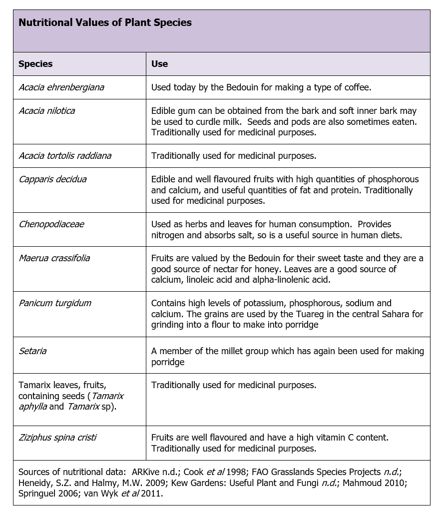 Table 8.13 – Ru’at el-Baqar period plant species
As Layton et al suggest, wild grasses tend to rank low in an optimal diet regime in dryland environments (1991, p.260), but the contribution of wild cereals can be inferred from the large number of grinding items at the site. Panicum Turgidum (figure 8.19-a) and Setaria (figure 8.19-b) grain impressions on pottery (Magid 2001) are evidence of the use of cereal plants at Nabta, and it can be assumed that much greater quantities than those represented by these two examples were present and consumed, providing valuable nutrients, including calcium. Both are illustrated in figure 8.13. Panicum is one of the most important grains in Africa today, the most abundant and the first to ripen after rains. It requires little preparation, is easy to digest and can be stored with little loss of quality for up to two years (S.E. Smith 1980, p.471). Setaria is often used as a form of porridge in the Sahara and is also eaten by animals as fodder, which also contributes to human nutrition (Magid 2001, p.608). Out et al (2016) suggest that during the mid-Holocene wild grasses and fruits were very important in subsistence strategies, but at Nabta, without knowing what else was employed it is it is impossible to comment. The fruit available provided sugars, carbohydrates and calories, as well as vitamin C in the case of Ziziphus spina cristi. At E-97-17, Irish has confirmed that wear on teeth are consistent with high volumes of plant food in the diet (Irish 2001). It is assumed that a much greater plant food component was present but has not been preserved.
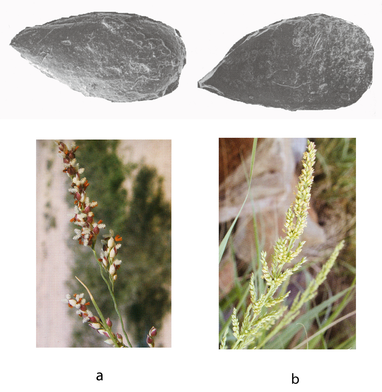 Figure 8.19 – a) Panicum turgidum (Microphotograph of seed
impression on pottery, Magid 2001, p.608; photograph Mahmoud 2010, p.104)
and b) Setaria sp. (Microphotograph of seed impression Magid 2001, p.608;
photograph Burke 2012, p.145).
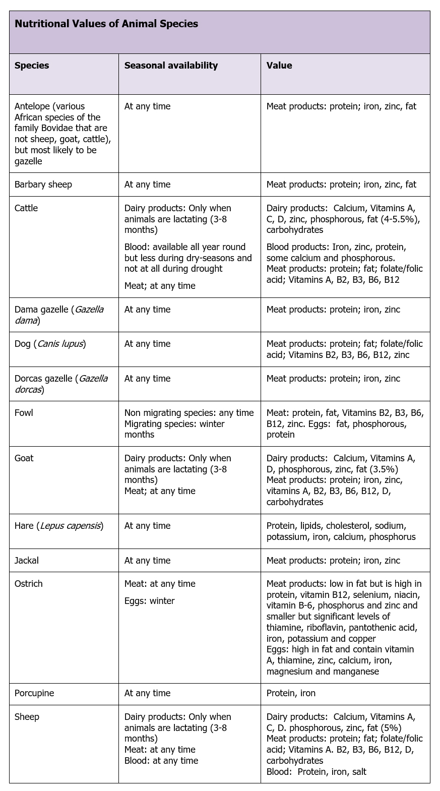 Table 8.14 – Potential nutritional contributions of animal species in the Ru’at el Baqar
Gautier’s analysis indicates that cattle are a minority in the bone assemblages (61.1%), whilst sheep/goat represent twice the amount (12%), and wild species the rest. The difference between cattle and sheep/goat can be accounted for by either Nabta groups using cattle herds for blood and milk or being reluctant to slaughter cattle (Gautier 2001, p.631). In purely dietary terms: “if we turn to dietary ratios, it becomes clear that livestock contributed substantially more to the diet, because the live weight and hence dressed carcass weight of sheep or goat (50kg?) and cattle (250g?), exceed markedly that of hare (3.5kg) and the combined gazelles (20kg).” Gautier estimates that by the Ru’at el-Baqar cattle make up about 12% of the diet and and small livestock make up around 26.8% of the diet, whilst wild species make up 61.1% (Gautier 2001, p.632). Porcupine meat is considered to be a delicacy in North and West Africa and is slow-moving, meaning that it is easy to catch, and it can weigh up to 30kg (ARKive, n.d.). Combined with the likelihood that cattle, goat and sheep were used for blood and milk as well as, or as an alternative to meat, this argues that the potential diet for the short season at Nabta was potentially very strong on animal products and high in protein. Ostrich has a number of nutritional benefits. Their meat is rich in protein iron and zinc.
Using the tabulated data in Appendix F and the above tables as guidelines, the above nutritional components could have provided the inhabitants of Nabta with a diet rich in protein, fat, iron and calcium but short of carbohydrates, polyunsaturated fats and certain vitamins that are confined to plant foods, such as vitamins C and E, folic acid, magnesium, and potassium. It is certainly the case that the diet of the Turkana consists primarily of milk during the rainy season in northwest Kenya (Galvin and Little 1999).
These deficiencies, if real, could have led to poor energy levels, high blood pressure, slow healing of wounds, scurvy, and muscle weakness. Fortunately, the occupants of Nabta were not present long enough for any of these conditions to develop, and the lack of green vegetables in the archaeological record is very unlikely to be an accurate reflection of the available vegetation.
Evidence of physical condition
The only burial that is securely dated to the Ru’at el-Baqar is the one in tumulus E-97-5. Although not particularly well preserved, and missing its cranium and other parts of the body, the skeletal data “suggest a young and healthy individual” with no sign of stress on lumbar vertebrae (Applegate et al 2001l p.478). It is impossible, however, to extrapolate from this one example. The much less securely dated burial at E-97-17 relateds to old age at the time of death, with severe dental attrition consistent with an “intensive gatherert” type diet and the teeth and mandible are suggestive of Sub-Sharan affinties (Irish 2001, p. 523).
Skills and knowledge
Although much knowledge may be transmitted with ease between generations, specific technological skills may require more investment. Probably produced at the household level on an ad-hoc basis, (Arnold 1985; Balfet 1965; Rice 1987, p.183-91) this was entirely compatible with a pastoral, mobile lifestyle (Grillo 2014; Eerkens 2008). The knowledge of pottery manufacture may have travelled within and between households over the generations. These types were already in use in the Nile Valley (Gatto 2002b; Nelson and Khalifa 2001), suggesting that they represent the adoption of a pristine invention by one or more groups, and the transfer of knowledge to others who seized both the technological and cultural opportunity.
8.3.1.6 Personal Assets
Individual status
Whether pastoralism led to new perceptions of roles is unknown, but the potential for new roles based on scheduling and external negotiations regarding trade and land use may have led to differentiated status amongst some individuals in society, if only on a temporary basis. The design of the ceremonial centre suggests that at least amongst a part of the population there may have been the opportunity to make an individual contribution to some of the ideological decisions that were made and the activities that took place at Nabta.
Security
There are no signs of conflict or competition for resources, and the use of Nabta over a period of centuries argues that it was regarded as a secure and attractive resource. Towards the end of the Ru’at el-Baqar conditions were certainly highly variable as aridification leading up to the arid phase became more obvious and was eventually accompanied by abandonment of the desert areas. Feelings of security may have been undermined towards the end of the Ru’at el-Baqar when Nabta, and whatever ideas were tied up in the ceremonial centre, had to be abandoned.
Ability to influence decisions
Most pastoral societies include a number of individuals in decision-making processes (e.g. Schareika 2014) and it can be proposed, on the basis of the complexity and social arrangements that are visible together with the lack of any indication that power was centred in one person, that decisions were required on an ongoing basis and that there were multiple participants involved. Although we cannot identify the contributors to these process we can be confident that they existed and that their opinions were factored into livelihood decisions.
8.4 The Livelihood Variables
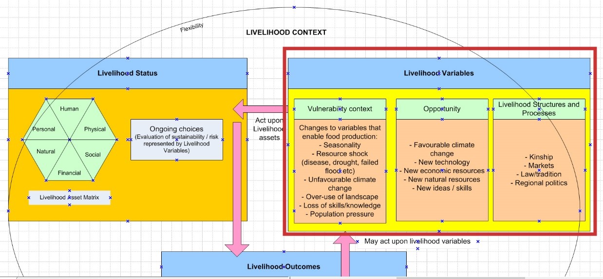 Figure 8.20 – The Livelihood Variables section of the SRL Model, framed in red
Figure 8.20 shows the components of the Livelihood Context. These are the explanatory elements of the SRL model, the variables that act upon the components of the Asset Matrix. Impacts can exist on a continuum between positive and negative. Each of the variables is discussed below.
8.4.1 Vulnerability Context
The Asset Matrix captures many of the important features of a community, but all the components that make up the matrix are dynamic and in a constant state of flux. During the Ru’at el-Baqar the dominant vulnerability is that of climatic deterioration at the end of the early Holocene caused by the southward movement of the ITCZ. This caused increasingly stochastic rainfall regimes and rangeland availability. Risk was mitigated by employing new economic systems based around herds, and new social systems based around the shifting character of the livelihood base. The most obvious areas of vulnerability that would have impacted life around Nabta is variable rainfall, influencing the availability of pasture during the rainy season and the availability of floodplain resources. As Nelson et al state (2016, p.298) “Managing disasters, especially those that are climate-induced, call for reducing vulnerablilities as an essential step in reducing impacts.” Nabta Playa during the Ru’at el-Baqar required a strategy of managing vulnerability via economic, social and ritual devices.
In this section, the system developed by Nelson et al described in Chapter 2 (Nelson et al 2016, p.300) is used to gauge vulnerability in access to food, and will be used to give a top-level assessment of the food resource situation at Nabta Playa (table 8.15).
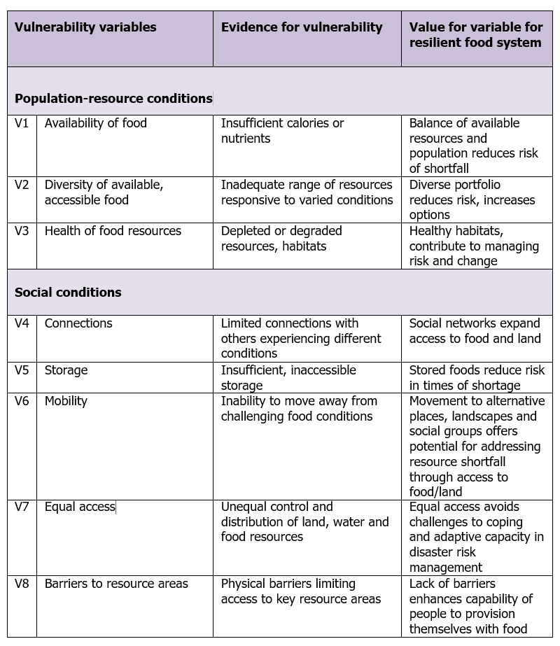 Table 8.15 – Vulnerability variables
The variables are ranked using a simple qualitative scale to measure its contribution to overall vulnerability. The qualitative ranking scheme is as follows for measuring each variable, based on contribution to vulnerability (Nelson et al 2006, p.300):
- No contribution
- Minor contribution
- More substantial contribution
- Substantial contribution
As there are eight variables the maximum vulnerability score is 32 (100%).
V1 Availability of Food: It is inferred that access to food and water was a short term requirement in Nabta, where the playa lake was only a seasonal phenomenon. For that time both the lake and the surrounding resources were sufficient to support herders and their livestock. All indications are that low numbers of people occupied temporary camps. It has been proposed that more secure resources were returned to after the lake dried up. If this was the case, food vulnerablility should have been relatively low.
V2 Diversity of available, accessible food: Although preservation of plant materials is poor, the availability of a suitable mixture of plant foods can be inferred from the species including fruits and cereals. Wild and domesticated faunal remains and the the availability of dairy argue that Nabta occupants had adequate resources to compensate for shortages in any one resource area.
V3 Health of food resources: All data points to temporary use of Nabta. Late rainfall and drought could reduce the value of plant and wild resources, and introduce vulnerablility into the seasonal visit, impacting the effectiveness of livelihood managaement.
V4 Connections: It is inferred, on the basis of seasonal occupation and cultural indicators, that Nabta occupants had connections with Laqiya to the south, the Nile to the southeast at Abka, or further to the south in the Kerma region. If these connections were secure, inhabitants at Nabta potentially had access to both dry season resources and support networks.
V5 Storage: There are almost no signs of storage, apart from the herds themselves. This might suggest failure to provide themselves with a fall-back supply of food for the duration of the stay, but is probably of marginal importance due to the brevity of the occupation and is unlikely to represent a serious vulnerability.
V6 Mobility: Mobility was clearly at the heart of the Nabta livelihood strategy, because the basin could only be occupied on a seasonal basis.
V7 Equal access: There seem to have been serious attempts to establish a symbolic and physical identity at Nabta, which may suggest that access rights had to be defended, but may also have been a reflection of the secuirty that Nabta represented.
V8 Barriers to resource areas: The desert itself forms a barrier to food provision in times of low rainfall. Even with the Nile to fall back on, this might represent a form of risk, particuarly if arrangements at the Nile required herds to be removed during the wet season.
The variables for Nabta, using best judgement best on the data captured in the assets are as follows in table 8.16:
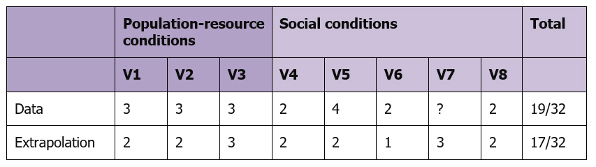 Table 8.16 – Vulnerability estimates for the Ru’at el-Baqar
This table suggests that throughout the mid-Holocene occupation at Nabta, access to food for the short period of occupation was deemed to be sufficient for the area to be used throughout the Ru’at el-Baqar, and visits to Nabta would therefore have been relatively low risk. It seems indisputable that Nabta was only occupied for short periods, and both the proximity of the Nile and the Nile-affiliated ceramics support the idea that the river was part of the Nabta subsistence strategy. However, should the proposal that Nabta was only used seasonally in conjunction with more permanent occupation along the Nile be incorrect, these findings would need to be completely revised.
8.4.2 Opportunity
Although Nabta was in an area of low rainfall in the mid-Holocene, there were various options for pastoralists and their herds. For a few weeks of the year, water accumulated in basins and behind dunes, and penetrated the thin soils as groundwater, promoting the regeneration of pasture and annuals as well as the maintenance of arid-adapted perennial species, and species that thrived under marginal aquatic conditions. Vegetation would fix limited organic nutrients into otherwise impoverished soils, helping to renew pasture annually. Conditions were probably not dissimilar from those pertaining in arid parts of the Sahel today, stochastic but offering variable subsistence opportunities for pastoralists. Although environmental change was detrimental to early Holocene subsistence strategies, the opportunities represented by domesticated species allowed dryland areas to remain in use.
Although domesticates were present in the Ru’at el-Ghanam, they were confined to sheep and goat in relatively small numbers. By contrast, in the Ru’at el-Baqar cattle were added to the livelihood mix, suggesting that the Ru’at el-Ghanam Middle Neolithic experiment was a successful one, and eventually became the strategic solution for the prevailing environmental conditions. By taking up the opportunity to diversify livestock, different benefits could be obtained for little more investment in terms of ongoing maintenance and knowledge acquisition.
The new livelihoods were accompanied by new cultural outputs, with new ideas and priorities reflected in the material record. These changes are probably connected to patterns of acculturation representing both the costs and benefits of taking up new livlihood opportunities in an increasingly constrained landscape of environmental stress and regional differentiation (Kuper and Kropelin 2006; Riemer 2007a; Riemer and Kindermann 2008).
8.4.3 External Livelihood structures and processes
The Nabta occupation, seasonal and dependent on the presence of a playa lake, gives few opportunities for exploring the potential impact of external structures and processes. It seems clear that during the arid phase between the Ru’at el-Ghanam Middle Neolithic and Ru’at el-Baqar the inhabitants of Nabta, already in possession of sheep and goat, came into contact with new ideas, in both subsistence and the social and symbolic realms, and that these were due to communication with other communities along the Nile Valley. However, the nature of those contacts cannot currently be examined from the Nabta evidence.
8.5 The Livelihood Outcomes
 Figure 8.21 – The Livelihood Outcomes part of the matrix, framed in red
The Livelihood Outcomes reflects changes that take place when the Vulnerability Context acts on the Asset Matrix (figure 8.21). This is discussed below in terms of three outcomes: economic, environmental and cultural.
Economic Impact
Following the abandonment of Nabta there are no signs of what happened next to the people who had occupied the playa. Just as it was impossible to trace with confidence a seasonal round for the Nabta inhabitants, it is not possible to track them after they left as the new arid phase caused increasingly stochastic condtions. Climatic downturn was accompanied by new patterns of usage of the available environments as suggested by Garcea and Hildebrand’s work on Sai Island: “In the end, riverside sites such as 8-B-10C may have been the receiving grounds for Saharan peoples as desiccation forced them to the Nile. The evident sedentary or near-sedentary use of 8-B-10C . . . indicated by closely spaced dwellings with numerous substantial support posts – might indicate that people became increasingly tethered to the Nile as rainfall decreased in the early middle Holocene” (Garcea and Hildebrand 2009, p.319). It is probable that Nabta occupants were forced to take up similar patterns of residence along the Nile in areas like Sai Island, and modify their livelihood strategies accordingly.
Environmental Impact
Small-scale societies often modify their local environments in a number of ways as part of a livelihood management process that Smith calls “cultural niche construction” (B. Smith 2011, p.264-5). Barakat believes that there are no patterns in any of the woody taxa from R’at el-Baqar Nabta to indicate that human presence at the site had any significant impact on the vegetation of the region, with the possible exception of Acacia nilotica and Ziziphus, both of which could have been introduced either as food waste or by animals eating and passing the fruit and seeds (Barakat 2002, p.599-600). The impact of these on the environment would have been negligible. It is unlikely that herds were present long enough to do serious damage to the ecology and they brought benefits. These include compacting of seeds and plant matter into soil to improve soil quality and water penetration; removal of dead biomass at the end of the dry season; reduction of bush fires; the revival of forage and the provision of dung as fertilizer (Grandval 2012, p.2). Savory (2015) describes how in today’s arid environments, desertification can actually be reversed by livestock herding. The extensive presence of wood in hearths may indicate that wood was either considered to be sufficiently abundant to use without negative consequences to trees, or that there were measures in place to prevent over-exploitation (Bollig 2006, p.336-7; Harir 1996; Hobbs 1989, p.53; Hobbs et al 2014; Krzywinski et al 1996; Simpson 1992; Wendrich 2007, p.74). It is impossible to pick between them. A climatic downturn at the end of the Ru’at el-Baqar, the Post-Late Neolithic Arid Phase, resulted in the abandonment of most of the Western desert (Kuper and Kröpelin 2006; Kuper and Riemer 2013; Schild and Wendorf 2002, p.24).
Social Impact
The Ru’at el-Baqar was followed by the Post-Late Neolithic Arid Phase (Schild and Wendorf 2002, p.24), which was in turn followed by the Bunat el-Ansam Final Neolithic during the Final Neolithic Humid Interphase and the final developments of the ceremonial centre with the addition of new Complex Structures, megalithic alignments and, a new feature, cemeteries, at Gebel Ramlah, 20km from Nabta (Kobusiewicz et al 2010; Wendorf, Schild and Associates 2001; Schild and Wendorf 2002, p.24-5). Heavy deflation has denuded the final occupation at Nabta, severely limiting information about subsistence and domestic aspects of the livelihood. The cemeteries relate to Nile rather than desert traditions, with similarities to burial traditions in the Badarian and in the Sudan at Kadruka, North Dongola Reach, El Kadada, Kadero and Geili, with an emphasis on single inhumations accompanied by grave goods including an emphasis on personal ornamentation (Kobusiewicz and Kabaciwski 2010, p.252). The shift of pastoralists into more constrained conditions along the Nile apparently coincided with and may have contributed to the growing importance of funerary traditions along the Nile and at Gebel Ramlah in the Final Neolithic, as an affiliation between groups and particular sections of land developed. Sapignoli’s observation that a connection to territory is common in small-scale societies (2014, p.48) and Frederick’s observation that some sites when used repeatedly throughout a year’s seasonal movement are part of what reinforces identity, ideas and social stability (2014) both seem to be applicable to Nabta. The cultural transformation of the Nile landscape and the erosion of links between people and the deserts were probably the main outcomes of the drying of the Sahara.
Ultimately, Nabta was abandoned permanently. The risks associated with the abandonment of Nabta obviously investigated those trying to continue to use it, buty they could have been considerable, including the costs of devising new livelihood strategies, the risk of abandoning any divine entities associated specifically with the ceremonial centre, and the loss of an embedded tradition of seasonal mobility and geographical diversity.
8.6 Answering the key questions
8.6.1 Why was the area attractive to occupants on an ongoing basis?
The dominant feature of Nabta Playa was the main basin and series of sub-basins that filled with water during the wet season, providing a temporary resource that continued to be accessed by wells after the water had retreated beneath ground level. The wet season was also responsible for sustaining a number of tree and shrub species which presumably created sufficient pasture to attract herders repeatedly to the area throughout the mid-Holocene. It was easily accessible from the Nile, so could have been used in conjunction with a Nile territory without major commitment of resources. Nabta is a “persistent place,” a locality used repeatedly over the long term due to the suitability of its particular characteristics including the accumulation of cultural remains as well as social and economic drivers (Shiner 2009; Schlanger 1992, p.91). Hofman emphasises that repeated use of the same areas and sites reinforces knowledge about those areas and improves the chances of survival, so scheduled return visits are desirable (Hofman 1994), a type of knowledge that becomes embedded in traditions based on a memory and past experience (Hunn 1993, p.13; B. Smith, B.D. 2011, p.263). Substantial ceremonial constructions indicate that as well as encampments there were activities that may have contributed to the perceived value of the Nabta area.
8.6.2 What types of risk were experienced?
8.6.2.1 Natural and economic risk
Most of the plant resources at Nabta would have been seasonal, with only a low density covering of tree and shrubs. Vegetation was dependent on rainfall, which could vary both temporally and spatially. As the mid-Holocene advanced, precipitation would have become increasingly stochastic, reducing the dependability of Nabta as a seasonal resource. High evaporation would have been responsible for lowering the water levels even in good years. If Nabta was a vital component of subsistence, it would have represented high risk. However, it is unclear to what extent the economy of the Nabta occupants actually depended upon a seasonal visit to Nabta. If the purpose was to rest dry season pasture elsewhere, any failure of precipitation would have required decisions to be taken about how best to manage the situation. It is probable that the annual trip to Nabta was based at least partially on social and symbolic rather than exclusively economic drivers.
8.6.2.2 Social risk
For individuals social risk lies in the loss of perceived status or prestige (Richards 2013). There are no signs at Nabta of status or prestige associated with any individual on an ongoing basis. For the group as a whole, any other social risk was probably to be found in the challenge to existing social arrangements, including affiliations with other groups and challenges to group identity from changing conditions along the Nile.
8.6.2.3 Symbolic risk
Whatever function the ceremonial centre served, it was a symbolic medium, and whatever ideas were invested in it will have derived from conceptual schemes embedded in ideology and religion. At Nabta symbolic risk must have been high. The ceremonial centre was not merely an investment in planning and labour but in ongoing use, a commitment to the ideas and beliefs that were incorporated into it. Failure of the ceremonial centre could have translated into the failure of entire belief systems and the underlying sense of livelihood security that accompanied them. Intensification of ceremonial activity may have corresponded to increasing subsistence stress, but the ceremonial centre was not destroyed at the end of the Ru’at el-Baqar and was added to in the Bunat el-Ansam, which seems to indicate that either the dating of the ceremonial centre is wrong and it should be placed in its entirely in the Bunat el-Ansam, or that the ideas that were initially expressed in the Ru’at el-Baqar continued to be observed during the arid period between the two phases, although no archaeological indicators have been found.
8.6.3 How were risks managed?
The available data has been checked against the list of risk management strategies in Section 5.4 in Chapter 5 and copied into Appendix B and forms the basis for a comparison of all areas. I have used a yes/no/? judgement on whether there is evidence for an activity, and have also indicated how much confidence there is in the data supporting that the judgement, using a High (H), Medium (M) and Low (L) scale. Table 8.17 shows what types of strategy are evident in the archaeological record. The contents are discussed in brief immediately afterwards.
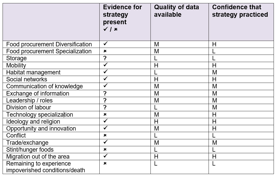 Table 8.17 – Risk management strategies employed in the Ru’at el-Baqar
- The combination of domesticated livestock, hunted game and the presence of grinders, presumably for processing grasses and other plant materials, combined with a certain amount of mobility, indicate a diversified approach to food procurement. Short term occupations combined beneficial effects on animals with the maintenance, via grazing, trampling and fertilization, of the land to which they returned, presumably on an annual basis, helping to achieve long term sustainability of both livelihood and the environment.
- Apart from Hut 1, there are no signs of storage, and even those at Hut 1 had no contents so their function remains unconfirmed
- The strongest risk management strategy, apart from diversification, was mobility, with the movement of individuals in and out of Nabta at appropriate times of the year. By taking herds to the richest pasture that was available, the health and value of herds was maximized. The ephemeral character and small size of sites suggest that mobility was probably logistical rather than residential.
- Habitat management may be indicated by the very presence of people at Nabta if they were resting dry season pasture elsewhere. It is possible that niche management was practiced by using briefly abundant areas like Safsaf (Close 1990; 1996; 2000a; B. Smith 2011), where small temporary sites were found, may have been used as supplementary zones for herding animals away from Nabta, returning to the basin when resources were depleted.
- Social networks are strongly implied by the ceramics, which have strong affiliations to the Nile.
- Successful knowledge transmission is also strongly implied by the ceramics, which indicate transfer of skills, as well as the ongoing need to manage herds, familiarity with the landscape, hunting of wild animals and collection the appropriate plant materials.
- There is no evidence for the exchange of information, which is archaeologically difficult to identify, but it seems unlikely that this sort of livelihood could be maintained without information about rainfall events, trading opportunities and social aggregation events.
- It is possible that religious leadership was required for the commissioning and ongoing use of the ceremonial components, and it seems likely that various projects required more than guidance and direction, but some of these roles could have been transient and there are no personal symbols of status or power or other archaeological indicators of leadership.
- Although there is no data, division of labour was almost certainly practiced in order to make the most of all ages and skill sets.
- There are few signs of technological specialization. The lithic industry was expedient, with only few distinctive types recognized as diagnostic indicators of the Ru’at el-Baqar, and it seems clear that nothing more sophisticated was required. Ceramics required greater investment of learning, skill and time.
- Risk was almost certainly mediated by ideological and religious values embedded in the ceremonial centre and associated with the change in ceramic design, both of which represent investments in activities that don’t connect directly with food production but probably connect to ideas of identity and social reinforcement. The tumuli suggest that people were ideologically pastoralist in their thinking, whilst the alignments and stone circle suggest that some ideas materialized at the site were centred on stellar observation. The ceremonial centre is a materialization of ideas in the enduring form of stone. The design includes multiple components with which, or within which, participants engaged.
- Opportunity and innovation have been discussed above.
- There are no signs of conflict.
- Trade and exchange are again difficult to assess, but indications of connections with a variety of different areas argue for links with different peoples, which may have involved exchange mechanisms.
- With respect to hunger foods, there are no indications that Nabta inhabitants were short of food, but choice would have been limited, and as the playa lake dried both food and water for human and animal consumption would have been in increasingly short supply.
- At the end of the mid-Holocene Nabta was abandoned and the seasonal occupants of Nabta in the Ru’at el-Baqar presumably migrated towards the Nile and/or elsewhere and re-arranged their subsistence strategies accordingly.
8.6.4 How can the livelihood be characterized in subsistence terms?
The Nabta Ru’at el-Baqar occupants were mobile herders of cattle, sheep and goat, who also used wild resources to provide adequate nutrition and preserve livestock during the wet season occupation. They are perhaps best characterized as herder-hunter-gatherers, or multi-resource nomads (sensu Salzman 1972), at least for the part of the year when they were at Nabta. No pastoral livelihoods today are exclusively dependent on herds, and plant nutrients must have been sourced. There may have been years when Nabta was not viable. It is most probable that the mobility exhibited by the Nabta inhabitants was restricted, possibly a form of semi-nomadic pastoralism that involved settlement at one or more Nile-side locations during the dry season, with herds moved to Nabta and perhaps elsewhere during the wet season. Judging by the fact that only a few hearths appear to have been used contemporaneously at some sites, it is possible that in most years only a few households moved to Nabta, or that households were left behind and only herding labour was required for Nabta. The presence of ceremonial components argues a stronger tie with Nabta than the otherwise ephemeral remains would suggest.
8.6.5 Has it been possible to identify where decisions have been made and what they were?
Whilst individual decisions cannot be observed, the accumulation of decisions are implicit in any risk management strategy. From an economic point of view, risk is a constant process of problem solving and decision making (Segal 1994, p.25). Both may be “relatively automatic” when the problem solver is experienced and the problem familiar (Segal 1994, p.26) but in conditions of environmental variability droughts may result in unusual or even extraordinary situations. Most decisions about occupation at Nabta were probably concerned with the interpretation of information about when to move, which routes to take, who should take part in that move and what sort of activities should take place on arrival.
Decisions are visible in the ceremonial centre, where different requirements were met with different solutions. Any proposal to create the various elements required agreement, design, implementation, refinement and reinforcement in the acts of repetition and ritual use of each element (Moser 2014; Olupona 2014). The ceremonial centre is a statement of an intention that was implemented according to a set of specific requirements and may itself have been used in order to inform decisions about when to schedule certain activities, forming a bridge between the physical and the numinous. An example can be given in the case of the table rocks. We know that a requirement was identified and that this was conceptualized in the form of the location and modification of the table rock as a process that was considered to meet that need. At least some individuals were responsible for acting upon the requirement to shape and rebury the table rocks, but they are not necessarily the same people who identified the requirement and decided upon its form. The following elements were combined in the decision making process: identification of a problem or risk (use of knowledge or information); proposal/s of one or more solutions (conceptualization and communication); choice of an appropriate decision (negotiation and conflict resolution); design of the solution (conceptualization and negotiation); planning about how and when to deploy labour (negotiation, co-ordination); supervision of works (leadership, delegation). Additionally, decisions about religious aspects of the process may have required the intervention of ritual specialists. We can assume that the first of these projects was successful, because it was repeated. However, towards the end of the Ru’at el-Baqar negotiating the challenge to the ideas bound up in the ceremonial complex may have been both difficult and traumatic. In lithic tool technology although the tookit was largely expedient, decisions were made about raw materials that tools should be made of.
The only other decision that is completely unambiguous in the archaeological record is that of abandonment following climatic deterioration at the end of the mid-Holocene. The decision not to return to Nabta may have been fraught with social and religious risk but was unavoidable due to the collapse of mid-Holocene rainfall regimes.
8.6.6 How has group identity manifested itself in the archaeological record?
Mechanisms for expressing cultural identity lie in the ceremonial centre and ceramics. The ceremonial centre expressed a common body of ideas, shared knowledge about its purpose and how it was used and probably included affiliation with and rights over land. The act of using the ceremonial centre may itself have been an integrating and reassuring activity, reinforcing and consolidating group identity by acting out roles that mediated beliefs. The distinctive ceramics seem to extend this sense of identity by incorporating the herders at Nabta within a wider realm of shared culture with the Nubian and Sudanese Nile, a deliberate behaviour of association. With the available evidence the emphasis seems to lie in group identity rather than individual differentiation. There are very few indications of personal identity. Ornamentation was not a big feature of the Ru’at el-Baqar. Although it is possible that other methods were used to express individuality, such as body paint, scarring or tattoos, it is also possible that a lack of any individual expression was a socially imposed constraint (Wiessner 1984, p.226).
8.6.7 What were the drivers for significant change at the end of each period?
The most obvious explanation for abandonment of this area, which had otherwise been used as a resource for hundreds of years is environmental deterioration followed by a hyper-arid phase. The switch from tolerable to intolerable conditions is unlikely to have been sudden, but rainfall at Nabta must have become increasingly unreliable, reducing its value over decades so that other economic solutions would have had to have been implemented to compensate. It the Nabta basin was associated with complex symbolic ideas, the adjustment could have been difficult on more than one level.
8.7 Conclusions – the value of the SRL model in this area
At Nabta there was one of the most comprehensively published of the four case studies, and was excavated using modern techniques, it offered great scope for testing the value of the SRL model and assessing whether it is a viable tool. The range of the questions that the SRL approach demands is considerable, and it was rewarding to apply a tool used by development economists on a much more restricted database. Certain parts of the matrix could not be populated with archaeological data, either because the data was not available or because of the way in which it had been published. Completing the Asset Matrix made such gaps transparent. These gaps include poor preservation of botanical and faunal remains, an absence of stratified sites, and the absence of skeletal remains that might have produced insights into various aspects of human living conditions that could not be substituted with other types of archaeological data. Where data was available, a very rich understanding of aspects of Ru’at el-Baqar livelihoods could be developed, particularly when supported by insights from ethnographic studies. The development of the Social Assets section particularly demonstrated the value of discussing the relationship between data and what it represented in terms of socially embedded concepts like ethnicity, identity and ideology.
Certain questions arose during the completion of the SRL framework that suggested opportunities for future research. Some of these were specific to Nabta, like the investigation of seasonal occupation with phytolith and diatom analysis of playa beds and stable isotopic analysis of data from livestock remains. Others are more general, for example the need to improve understanding of the functionality of stone tools and the requirement for a geological databaseof Egyptian and the Sudanese stone and mineral types. Other opportunities for future research are discussed in the longer version of the case study and referred to in Chapter 10.
The key questions have provided a test for the SRL approach, indicating that problem orientated research is a suitable use of this method. Although it was not possible to answer some of the questions definitively, or even usefully, this again highlights gaps in the data and might suggest potential areas for future research, some of which are mentioned in Chapter 10.
The case study required considerable investment of time. Although fragmentary data is available in publications, assembling it in the required format and putting it to work was far more time consuming than I had anticipated. It was a rewarding and productive exercise, but the large amount of time required to use the approach in archaeology would need to be factored into any future projects on a similar scale.
