
9.1 Introduction
This chapter brings together some of the themes extracted from the data-rich narratives supplied by the completion of the Sustainable Rural Livelihood case studies. The case studies were not always directly comparable in all aspects of the matrix. Each case study was strong in particular types of data, but either due to accidents of preservation or quality of publication some types of data were not available in all the case studies. In terms of subsistence, human and physical assets, none of the case studies was particularly strong, but they were reasonably comparable. In terms of social aspects, each area had something different to offer. The ceremonial centre and ceramics at Nabta, the Badarian cemeteries and grave-goods, the Gilf Kebir rock art and the Dakhleh bifacial tools all provided different avenues to explore, but the findings are not always directly comparable, although certain holistic evaluations are possible. The findings are presented below.
Due to both time and space constraints, it is not possible to compare each and every aspect of the SRL matrix within the scope of the thesis, so two strands of vulnerability and risk management have been isolated for comparison:
- Risk, vulnerability and sustainability, which were identified as topics for investigation in the introduction, are compared here:
- Risk management strategies and uncertainty (section 8.3.1)
Livelihood strategies adopted by prehistoric pastoralists in the case studies are assessed against strategies employed by modern pastoralists as described in Chapter 5. An example of this has been given in Chapter 8, with the abridged Nabta Playa case study, and is also included in each of the full case studies on the CD-ROM. - Vulnerability (section 8.3.2)
The data captured in all four vulnerability tables is compared with a view to demonstrating the overall levels of risk and uncertainty encountered in this part of the eastern Sahara. - Sustainability (section 8.3.3)
The long-term viability of livelihood strategies in the four case study areas are compared by focusing on relevant components of the Asset Matrix
- Risk management strategies and uncertainty (section 8.3.1)
- The Key Questions (8.3.4) that were introduced in chapters 1 and 7.
In each of the case studies nine identical questions were asked to test whether the SRL approach could be used to answer specific questions about livelihoods in marginal environments and were addressed in each of the case studies. Answers to the key questions are compared briefly here.
9.2 Comparative Findings
9.2.1 Risk Management Strategies
The four livelihoods under discussion are all pastoral. In each case of groups developed livelihood strategies to suit geographic and topographic landscapes in dryland zones during a period of increasing aridification. Table 9.1 assembles the data presented in the case studies, based on the research into modern pastoralists described in Chapter 5, to begin a top-level comparison of the risk management strategies adopted in all four areas. A yes/no/? rating was used to indicate presence or absence of a technique, together with a confidence rating of High (H), Medium (M) and Low (L).
 Table 9.1 – Risk management strategies compared
Due to word-count constraints five topics have been chosen for discussion; other aspects will be discussed when sustainability is assessed below. The five topics were selected expediently, as they represent aspects of livelihood management that should be detectable archaeologically.
- Food diversification, looking specifically at livestock choices
- Ideology and religion
- Tradition
- Mobility
- Uncertainty at the end of the mid-Holocene
9.2.1.1 Food diversification
The following QFD (Quality Function Deployment) analysis was introduced in chapter 2. Here it is used to discuss choices made regarding cattle, sheep and goat in the four case studies. The QFD table was compiled partly from the data tabulated in Appendix G. The inclusion of pig in the QFD table will be explained below. In figure 9.1 below each species is given a numerical rating against criteria of usefulness. For example, heat tolerance is considered to be of high importance (9) but pig has low tolerance so it is given a rating of only 2. The ratings for each species are totalled to provide an overall value for each one. This is a subjective approach, but gives a sense of the sort of decisions that were available to livelihood managers, and suggests some of the reasoning behind the decisions that were made.
As well as being most obviously a source of meat, livestock represents renewable stores of dairy and blood. The animals are themselves renewable via reproduction. They also represent non-renewable stores of meat, bone, horn, sinew and hides.
 Figure 9.1 – QFD analysis of the relative merits of cattle, sheep, goat and pig
In all case studies cattle and goat were present and sheep were represented in all except Dakhleh Oasis. In a dryland livelihood each has its own merits. Given sufficient water and fodder, cattle are excellent sources of dairy, blood and meat. They are not particularly heat, drought or saline tolerant, require greater quality and more volumes of food and water than either sheep or goat, and have a gestation period of 9 months and only one calf per year. In their favour, they also have long lifespans, milk is plentiful when cattle are healthy and they have high energy reserves (Dyson-Hudson and Dyson-Hudson 1980). Ovicaprids are more versatile. Goats are useful for arid environments because they are both drought and heat tolerant, will consume poor quality fodder and household waste, and reproduce well. They also have a longer lactation period than sheep (Degen 2007). Sheep are less drought and heat tolerant than goat and are less tolerant of poor quality fodder but reproduce well and the nutritional quality of their milk exceeds that of cattle and goat, although cattle produce greater volumes. Ovicaprids have a six month gestation period, 3 months shorter than cattle, and may produce up to two individuals twice a year (Smith, A.B. 1980). All three therefore offer different benefits to livestock keepers.
Pig was one of a number of species imported from the Near East and present in the Faiyum Neolithic, Saïs and Merimde Beni Salama, both in the north of Egypt during the 6th millennium BC. Thomas (2003) and Dittrich (2017) both refer to the Near Eastern domesticates as a set of options from which those who came into contact with them could select, and this selection process is identifiable throughout the northeastern Sahara at different times. Domesticated plants and pig only became available via the Sinai land bridge or the Mediterranean into the Delta (Close 2002b; Hassan 1988, Tassie 2014, p.187). Ovicaprids separately appear to have followed a second and separate route into the Eastern and Western Deserts via the Red Sea (Dittrich 2017; Vermeersch et al 1994; Vermeersch 2008; Shirai 2013), entering Nabta and the oases in the 5th millennium BC. It was not until the 5th millennium that domesticated flax, emmer and barley appeared in the Badarian. Assuming that flax, emmer wheat and barley could have been introduced into the Badarian from the Faiyum or Delta, it is interesting to see that pigs were not adopted whilst flax, wheat and barley apparently were. Logistical difficulties could have accounted for this, but economic reasons are a more plausible explanation. Pigs are demonstrated to be very versatile in terms of how prolific they are in terms of production, and are highly tolerant to poor quality fodder, both features that might have been very attractive in the Badarian. But they are not at all drought tolerant, are poor convertors of cellulose, may be in competition with humans for the same foodstuffs, can suffer ill-health in high heat without shade, require water or mud in which to cool down as they do not perspire, do not provide milk, cannot be herded conveniently with other livestock and can be devastating to crops if not adequately restrained (Linseele 2010; Yokell 2004), all of which may be why they were rejected.
In general terms goat and pig are therefore by far the most versatile of the domesticated species represented, with cattle dominating in terms of dairy supply, volume of meat, lifespan and supply of hides. However, although a good source of meat and offspring, pig was associated with predicted difficulties. Ovicaprids would therefore seem to be the ideal solution for all people living in arid and semi-arid environments, occasionally supplemented by cattle when water availability could be reliably provided and where livestock could be moved between good quality pastures. Between them, cattle and ovicaprids are suitable for different environmental niches, have different tolerances and offer different nutritional benefits, meaning that they complement each other in variable conditions. The combined presence of cattle and ovicaprids is an indication of sensible livelihood management and diversification seems to have been preferred to specialization.
Plant collection will have been important for basic nutritional requirements, with grinders suggesting that processing of plant foods such as seeds, roots and tubers took place. This corresponds to proposals by, amongst others, B.D Smith (2001) and Marshall and Hildebrand (2002) that there is a shifting continuum of activities taking place in many prehistoric communities that are neither hunter-gatherer nor agricultural, nor necessarily transitional between them. The Badarian is unique in the case studies in providing evidence for domesticated emmer wheat and barley. The following schematic from the Badarian case study (figure 9.2) shows what sort of decisions would have been involved in a choice of cereals from a purely technical point of view. Sorghum, included for comparison, was potentially available given that although it was not domesticated it was a staple in both the Sudan to the south (Haaland 1995, p.128-171; Lucarini 2014b) and in Farafra Oasis to the west in the Western Desert (Lucarini 2006), with which the Badarian may have had links. However, as a summer-rainfall crop it was not suitable for the temperate conditions that dominated in late mid-Holocene Egypt. Barley and emmer were both available from the north and were suitable for the prevailing environmental conditions. Both were equally suitable for subsistence needs and, should it be required, to generate a surplus and contribute to nutrient intake, minimizing the labour required for grass seed collection.
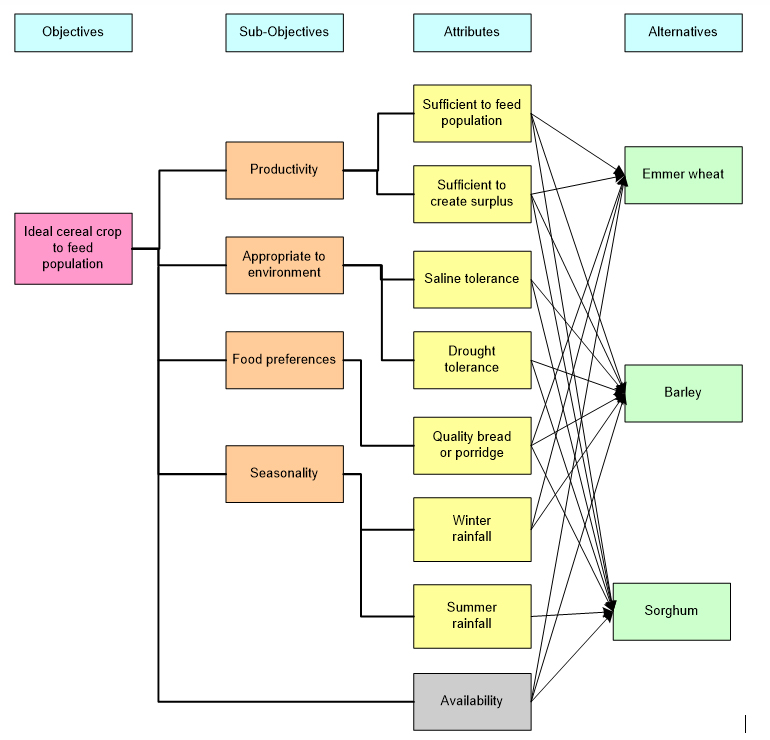 Figure 9.2 – The relative benefits of emmer wheat, barley and sorghum
The benefits of barley include a shorter growing season than wheat, being planted later and harvested earlier than wheat. Planning and harvesting of cereals could have been staggered, which may have had benefits in terms of labour provision, the ability to make and consume cereal products over an extended period and to allow herds to graze on the parts of the crop that were not used. Barley and wheat were probably planted in different zones to take advantage of their tolerances, with drought and saline tolerant barley confined to the floodplain edges and wheat cultivated in the wetter floodplain.
9.2.1.2 Ideology and Religion
As discussed in the case studies, in terms of risk management, concepts of group identity and cohesion are important to ensure that livelihoods are not merely economically viable but support community cohesion, particularly when communities separate and re-assemble at different times of the year. A common set of religious beliefs, the rituals that materialize them and the underlying ideologies may be expressed through material output, and is often an important symbolic component of livelihood systems (Berkes et al 2000; MacEachern 1994; van de Leeuw 1993), allowing complex social organization to function. In each of the case studies considerable effort has been expended in demonstrating how communities invested in ideology, religion and tradition. One of the interesting results of the assessment is that three of the areas exhibited strong indicators, and all four are conspicuously different from one another.
Funerary activity was represented in one of the case studies. Although there are burials in the Ru’at el Baqar of Nabta consisting of stone tumuli containing the remains of cattle and ovicaprids and one human male, they appear to have more to do with a symbolic statement related to Nabta and its seasonal use than any embedded funerary tradition. They have a closer resemblance to shrines than cemeteries. The earliest of the tumuli contained the articulated cow; it is possible that subsequent tumuli were built to reinforce whatever message was contained in E-94-1N. A completely different and infinitely more elaborate and intensive funerary tradition took place in the Badarian where 42 cemeteries in three main concentrations contained c.500 excavated graves (Brunton and Caton-Thompson 1928; Brunton 1937, 1948). The Badarian is characterized by these cemeteries, composed of individual graves, mainly individual inhumations, most orientated with their heads at the south on their left side facing west, but there was considerable variability (Castillos 1982). Animal burials are also recorded (Flores 2003). Individuals were accompanied by grave goods including ceramics, items of jewellery, cosmetic objects, exotic shells, amulets and stones, as well as rare small sculptures. The burials in both the Badarian and Ru’at el-Baqar, whether human or animal, suggest a strong affinity with the land, but those of the Badarian are more explicitly part of a strong funerary tradition in which the individual is an important concept, and was apparently equipped for an afterlife. The absence of funerary remains in Dakhleh and Gilf Kebir, suggest that alternative methods were used for disposing of the dead (e.g. Klima 1970, p.102).
In each of the case studies personal and group identity appear to have been expressed materially, albeit in very different ways. Sillar and Tite discuss how “materials and techniques may be dependent on wider cultural values and ideological concepts that stretch beyond any single technology” (2000, p.9) whilst Gosden (2001, p.166) talks about “highly charged objects” that mediate between people’s physical activities and their more abstract evaluation of their lives. Personal ornaments in the Badarian suggest an increasing sense of individual identity, perhaps a manifestation of increasing individuality and the importance of defining a group’s identity, but also potentially indicating differential access to certain goods. Ornaments were found in Dakhleh, but the volumes and contexts are not published and may be a minor component of assemblages in settlement contexts. It is, of course, possible that body painting or other forms of marking were used instead of ornaments, especially in the Gilf where painting (on rock shelter walls) was a feature of the Gilf C, and where ochre was available locally (Krause et al 2013, p.59-61; Leisen et al 2010, p.9-10). Rock art in the Gilf C may have been an expression of group identity and the connection of groups with particular areas of the landscape. Lenssen-Erz has suggested that differences in rock art may reflect connections with different groups in different parts of Jebel Uweinat (von Czerniewicz et al 2004; Lenssen-Erz, T. 2012), and Gilf Kebir may be a northern extension of that pattern. In Dakhleh the production costs of bifacial tool technology (Shea 2013, p.39-45; Gero 1989, p.94) were higher than the remainder of the more expedient toolkit and may have been connected with ideas about affiliation with other oases and desert sites, including Farafra and Djara, which shared the same type of intensified bifacial tool manufacture (Edmonds 1995, p.41-2; Gero 1989). In this sense, it is the meaning rather than the activity that was specialized. Bifacial technology may be part of an abstract language of expression where choices of cultural output materialize identity.
Livestock also have an important role in social mechanisms and ideologies including religio and may be part of a group’s worldview (Dittrich 2017; Oma 2010; Orton 2010). At Nabta the burial of one whole cow and dispersed pieces of cattle, goat and dog indicate that their importance in other tumuli exceeded the purely economic. At the Gilf Kebir, cattle and some ovicaprids in rock art suggest that various aspects of livestock were particularly revered. The presence of animal burials at Nabta and in the Badarian are both suggestive of the importance of livestock to the worldviews of both places. Whereas at Nabta the animal burials in the tumuli are of domesticated species, in the Badarian gazelle also appears to have been included, although the identification is not completely secure, Brunton placing question marks against his identifications (Brunton and Caton-Thompson 1928; Brunton 1937, 1948).
The main form of expression in the Ru’at El Baqar was the ceremonial complex that took considerable planning and some investment in construction. It has no parallels in any of the other case studies, or anywhere else in the eastern Sahara but may be an extension of the ideas connected with localized group identity, a sense of place, and the importance of engaging with seasonal aspects of the livelihood (Jesse et al 2013; Lenssen-Erz 2012; Turton 2005, 2011; Wendorf and Schild 1980, p.270).
Gillian Woods has suggested that a shamanic element may exist in all four of the case study areas, based in Nabta on the human burial, in the Badarian on the presence of steatite bead belts in a small number of graves, and in Dakhleh and the Gilf Kebir on rock art (Woods 2016). This was considered in each of the case studies except Dakhleh, where rock art is present but was not employed in the case studies due to the difficulties of dating it. In the areas represented by the case studies there was insufficient data to confirm or deny a shamanic presence in these areas.
The evidence for ideology and religion may be connected with the intricacies of mobile pastoral lifestyles that also need mechanisms for managing shared natural resources and negotiating access to special resources like springs and temporary water sources. Ecological management strategies are almost always regulated by social mechanisms, often mediated by various aspects of religion and worldview (Berkes et al 2000, p.1256). Distinctive cultural output seems to relate to new ways of organizing life based on the adoption of delayed return strategies, dairying, new concepts of ownership, new patterns of mobility, and new ways of sharing both resources and products. MacEachern’s research into shared symbolic components over wide areas suggests that material was used both to express connections and to differentiate groups from one another, reflecting the complexity of relationships and social mechanisms (1994, p.211). He suggests that symbolic components could remain stable for centuries, but are also subject to manipulation (p.214) and do not express ethnicity but connectivity. Most of the above case studies are consistent with this type of explanation, where characteristics unique to each area are combined with features shared in other areas. Dakhleh is the exception; there are no clear indications of how ideologies and religious beliefs were expressed, and this may be due to lack of surviving data, a different way of organizing social connections, or an entirely different way of expressing ideas and beliefs based around resource management in an oasis environment.
9.2.1.3 Tradition
Tradition is a useful concept because it suggests a connection with the past, a sense of linking with ideas that emanate from an earlier time and give significance to current ways of doing things a validation based on long established knowledge, wisdom and ideology. Tradition may be a powerful tool for reinforcing power structures, group identity, kinship links and community laws (MacEachern 1994; Wobst 2000). It is therefore useful to try and identify where it might lie in the archaeological record, particularly when many of the religious and ideological manifestations described above emphasize change from previous periods rather than representing continuity. Wobst (2000, p.47) suggests that when ideas and routines are under threat certain cultural norms will be adhered to in order to preserve tradition. It is therefore not surprising if in the face of economic and social change some aspects remain the same as forces of change and conservatism both act on people.
Tensions between innovation and tradition of the sort discussed by Wobst may be found in two of the case studies. At Nabta the ceramic assemblage is consistent with types found in the Nubian Nile and may indicate a strong affinity with groups who moved into the Nile area after the more humid early Holocene, adopting new cultural components at the same time. The combination of a unique ceremonial complex with a ceramic assemblage influenced by the Nile may suggest that Nabta was the survival of a much earlier tradition, as exemplified by the tumuli at E-06-4 (Bobrowski et al 2014) a tradition that may have grown to be increasingly important as the desert dried and connections with desert communities became more difficult. A similarity between ceramics and tradition seems to occur during the Badarian where ceramics may have had an important role in defining identity by associating the group with earlier ceramic production in the Sudan. Black-topped ceramics, in particular, seem to have developed out of a tradition that was found both in the Sudan and in the desert (Nelson and Khalifa 2010), and suggest an affinity with an idea of heritage, but there were many forms and treatments that have no precedent and serve to emphasize the individuality of the Badarian. Gilf C rock art builds on an earlier but very different rock art tradition in the Gilf Kebir and Jebel Uweinat apparently located deliberately in the areas of Gilf B rock art, some considerable distance from Gilf C settlement sites. On a shorter timescale, some scenes were clearly superimposed on earlier ones, indicating that they were used repeatedly, but with a consistent underlying purpose. Together, the ceramic condition suggesting a regional affinity and the localized but long-term traditions of rock art that may have a role in expressing affinity or rights of access to certain resources suggest that the role of time, repeated use and reference to longstanding traditions, are all important parts of the way in which the livelihood was managed at multiple timescales over different areas. The Bashendi B in Dakhleh is in many ways a continuation of the Late Bashendi A in terms of the presence of domesticates and bifacial tool technology, but there are also substantial changes including a decreasing reliance on wild fauna, a dependence on domesticated cattle and goat, the loss of hollow-based arrowheads from the bifacial toolkit and the absence of Bashendi A stone-built structures. Items of personal ornamentation change, and site distribution is different. The published data is limited, making it difficult to speculate, but the continuation of bifacial technology does seem to be based as much on tradition as functionality. Although there are clear differences, there seems to be a balance between continuity and change.
Bringing together all the case studies there is a suggestion that as well as changes in worldview connected with new livelihoods, there was a drive to maintain links with the past, to reinforce economic and social aspects of livelihoods by reference to ancestry or cultural heritage. Ideas of economic and cultural innovation were combined with an impulse to reference the past. This may have been an integral part of the incipient funerary tradition that emerged along the Sudanese Nile, in the Nabta Bunat el-Ansam (Final Neolithic) and in the Badarian.
9.2.1.4 Mobility
Different patterns of mobility, the most flexible form of adaptation to arid environments, can be observed in each of the case studies. As discussed in Chapter 5 and in the case studies, mobility has both subsistence and social benefits. As well as allowing dryland rangelands to recover and rest, it enables livestock to benefit from new pasture and build up strength. Being aware of good pasture is a prime function of mobility among pastoralists, which is also facilitated by social interaction and inter-group relationships. Social benefits are demonstrated in a number of examples in the case studies, where mobility may be essential to exchange, to connecting with kinship groups and support networks, and to how groups define themselves.
In Nabta during the Ru’at el Baqar it seems probable, based on the similarity of ceramic styles, that the occupants practiced a pattern of transhumance between the Nile and, for a short part of the year during the rainy season, the desert. It is possible that part of the community remained behind at a Nile valley location, probably in Upper or Lower Nubia, whilst herding parties were dispatched to the desert to make use of seasonal rainfall and pastures. One possible linkage between the Nile and Nabta is the short distance between the Nile and the playa basin (between one and three days away), but judging from affinities in cultural output between Nabta and the Sudan (Gatto 2002b; Lange and Nordström 2006; Wendorf and Schild 1998, p.108) it is possible that groups moved along a north-south axis, which could have taken up to several weeks between Nabta and Nubia or further south into the Sudan. There are also indications that raw material acquisition took Nabta herders to the north, where a source of flint was available 70km away. The social and subsistence risks were mitigated by a number of mechanisms and it is possible that whilst climatic failure undermined economic systems, religious beliefs reinforced confidence, whilst also continuing to fortify social identity. The lack of evidence of Nabta assemblages to the west beyond Safsaf or beyond the Nile to the east suggests that Nabta occupants were circulating between Nabta and one or more other locations including the Nile valley. Nabta’s role as a wet season pasture and ceremonial centre suggests that it would have had a strong pull on herders for both economic and more numinous reasons. The risk of travelling to a temporary rainfall reservoir was considerably diminished by the proximity of a permanent water source (the Nile). Although also partially transhumant, the Ru’at el-Baqar scenario differs considerably from the Gilf C.
Gilf C occupants were mobile over a large area. The main pattern of larger scale mobility detectable is that between and around Gilf and Uweinat 120km to the south and Jebel Kamil, less than c.50km to the southeast. Gilf C occupants certainly used a transhumant combination of residential and logistical mobility, using the Gilf as an extension of Jebel Uweinat, and they may have roamed further afield as well. The practices of regional and localized mobility were combined to make the most of different resources, marking points in the landscape for either territorial purposes or as ritual focal points, or both. Within the Gilf Kebir it is probable that a high degree of logistical mobility was practiced, and this is certainly suggested by the Gilf C the network of base camps within the wadis and smaller camps and ateliers proposed by Linstädter (2003). The distribution of “Gilf type” grinding stones and herringbone-decorated sherds at Laqiya c.350km to the south, in the Sudan, Abu Ballas 150km to the northeast, all suggest that the Gilf Kebir and Uweinat were part of a network of communication (Kuper 1989, p.200) suggest links between these areas. Unlike the Nabta scenario, the Gilf C groups were weeks away from generous perennial water sources. Although springs came to the surface in the Jebel Uweinat area, these were probably shared by numerous herding groups in the area, and being focal points, herds would have run the risk both of over-grazing surrounding grasslands and coming into conflict over access to water (Adriansen 1999, 2008; Binns 1992; Hunn 1993; Rodríguez-Estrella 2012).
In contrast to Nabta and Gilf C, water shortages were a low risk for Badarian inhabitants and the food production system would not have required similar patterns of mobility. Although it is probable that Nile-side occupation shifted seasonally when the floods arrived, and that when rain fell wadis and low desert were used to herd livestock there is not sufficient data to assess what combination of mobility practices were employed. Nor is there currently any evidence to confirm that wadis and low desert were used in periods of rainfall, but it seems probable and in this scenario logistical mobility would have been practiced due to the benefits of providing herds with new pasture, avoiding illness and disease in the waterlogged floodplains. If it is accepted that the Badarian included a component of small-scale cultivation, herds of domesticated animals would need to be maintained away from the floodplain following retreat of water to prevent trampling and crop consumption. One model for managing these two resources was that of the Himba in Namibia, where during the dry season only lactating animals are kept close, and herds are moved to dry season pastures, whilst during the wet season grazing was around households and near river soils (Müller et al 2007, p.1871).
The Bashendi B is different again, demonstrating high mobility on a year-round basis within the oasis, making use of areas beyond the oasis during wet periods. Being bound by increasingly arid desert, and benefiting from bimodal rainfall and natural springs, Dakhleh had both advantages and disadvantages. A relatively rich environment would have been easy to over-exploit and a model of perpetual movement, such as that of the Fulani/Borani (Binns 1992), where groups move at least once a fortnight and sometimes every few days, might be appropriate. Mobility would also have been required to support social activities like trade, reinforcement of kinship links, religious aggregation and the sourcing of marriage partners (MacDonald and Hewlett 1999; Whallon 2006) and may have extended to Kharga Oasis and beyond Kharga to the Nile (Brirois et al 2010, Brirois et al 2012; Lesur et al 2012). More fieldwork (and its publication) is needed to confirm this.
Although it is not possible to be precise in most cases about the types of mobility practiced, the case studies demonstrate that eastern Saharan pastoralists were very adept at employing mobile patterns suitable to multiple environments. Different topographies, rainfall regimes and water sources offered different opportunities and constraints. All four case studies differed in their form of livelihood management, indicating variability and the implementation of solutions that are familiar amongst today’s pastoralists. This indicates that there are many livelihood strategies available to mobile pastoralists.
9.2.1.5 Handling uncertainty: the end of the mid-Holocene
Risk is a manageable situation, handled with inherited knowledge and experience. Uncertainty is the point at which risk cannot be handled by existing knowledge and wisdom (Knight 1921). In only one case do inhabitants appear to have remained in the area to experience impoverished conditions and early death. Some of the options available are shown below in figures 9.3-9.9.6
In the case of the Gilf Kebir (figure 9.3) it is probable that after leaving the Gilf Kebir at least some of the occupants moved south to Laqiya, some 400km away (Kuper 2007, p.9). In the case of Dakhleh Oasis (figure 9.4), some people clearly left, possibly to the Mediterranean or elsewhere, whereas others remained (McDonald et al 2001). In the case of Nabta (figure 9.5), the seasonal occupation simply ceased during for many decades, with groups presumably either concentrating activities in other areas that made up their seasonal round, or finding alternatives. In the case of the Badarian (figure 9.6), there is no clear end to the cultural phenomena, some of which were retained in the subsequent Naqada I period over a much greater area and it seems probable that desert and Nile traditions merged as expanding population density required the establishment of new territories and negotiated new social relationships.
 Figure 9.3 – Choices facing occupants of the Gilf Kebir at the end of the mid-Holocene
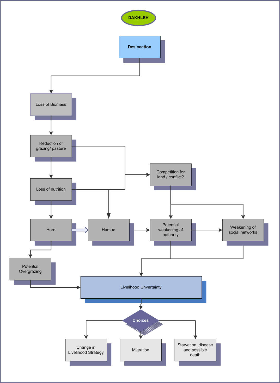 Figure 9.4 – Choices facing occupants of Dakhleh Oasis at the end of the mid-Holocene
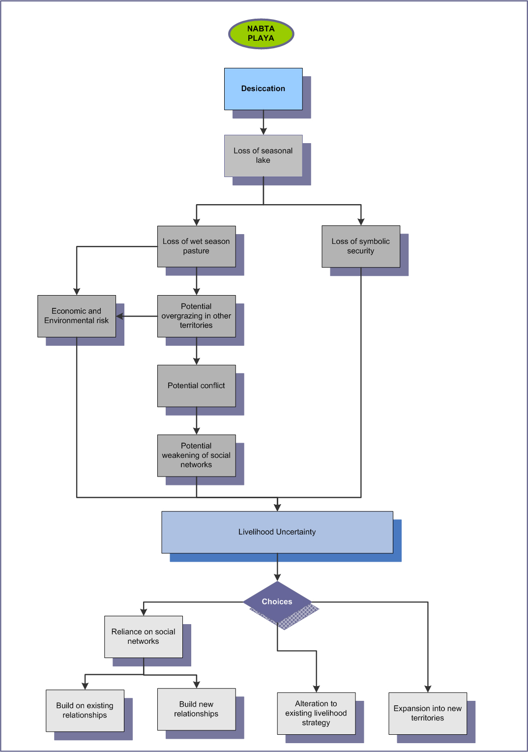 Figure 9.5 – Choices facing occupants of Nabta Playa at the end of the mid-Holocene
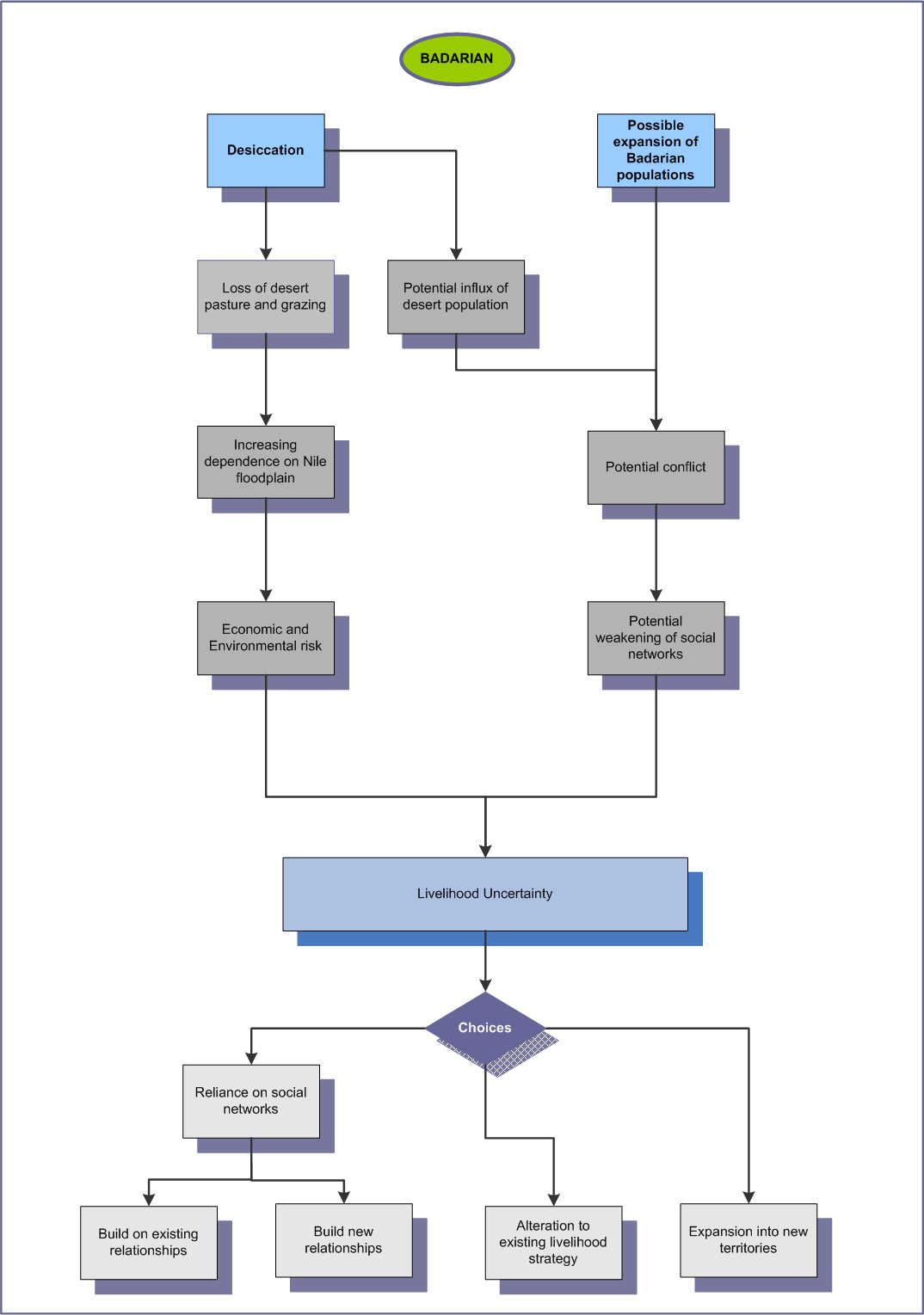 Figure 9.6 – Choices facing occupants of the Badarian at the end of the mid-Holocene
9.2.2 Comparing Total Vulnerability
The main objective of the Vulnerability Table, which has been used in each of the case studies, is to assess individual areas of vulnerability and to generate a cumulative figure by which to assess the overall vulnerability of each of the livelihoods described. Designed by Nelson et al (2016) the variables used are somewhat holistic and inductive, but include both natural and human influences, and result in a qualitatively derived number on a scale of one to four that represents the approximate vulnerability of each livelihood. The Vulnerability Table in Table 9.2 shows how the cumulative vulnerability variables are assessed, and table 9.3 shows the results from the case studies.
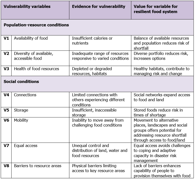 Table 9.2 – Vulnerability variables (after Nelson et al 2016)
Vulnerability factors are scored out of 4, with 4 representing a variable giving the highest vulnerability and 1 the least, with a maximum score of 32 (100%).
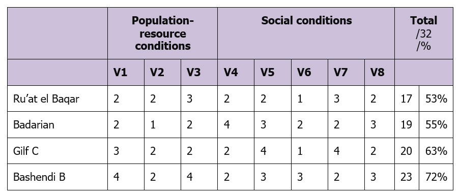 Table 9.3 – Vulnerability variables for the case studies (extrapolated)
As table 9.3 demonstrates, there is a degree of vulnerability in all areas, but the figure seems relatively low for marginal environments. This is because the scale is one established just for areas that are inherently vulnerable, meaning that results are on a continuum that reflects situations where risk is the norm. The table reflects quite a high degree of vulnerability, requiring multiple livelihood strategies and considerable flexibility to counter natural conditions.
The results suggest that the Ru’at el Baqar and Badarian are the least vulnerable of the four case studies, although for very different reasons. The Badarian is in an area of multiple environment options that provided year-round water, pasture and human nutrition. The community had social structures to support group identity, ideology and subsistence systems that were suitable for the conditions along the Nile. Some degree of mobility was practiced, providing flexibility. Some evidence of storage was found and social connections over a wide area were probably in place. By contrast the main strength of the Ru’at el Baqar is that it was a purely seasonal occupation, with strong affinities to the Nile, only a few days walk away, suggesting that the main strength of this phase in Nabta was based around the Nile with Nabta providing an important secondary source of pasture and water.
Gilf C was heavily dependent upon the lakes formed behind dune barriers. Whether or not it was perceived at the time, it was an inherent risk that the dunes might be breached. The breaching first of the blocking dune at Wadi el-Akhdar, leading to its abandonment in favour of Wadi el-Bakht, and then of the final dune barrier led to the abandonment of the Gilf Kebir.
The Bashendi B, perhaps surprisingly, seems to be the most vulnerable of all the areas. Although Dakhleh experienced bimodal rainfall and the underlying aquifer produced perennial springs, the use of a limited territory may have been associated with the risk of the over-exploitation of resources together with the danger of conflict over water and land. At the same time, these risks were probably mitigated by social networks, specialized tool technology, high levels of mobility and perhaps access to resources in neighbouring Kharga Oasis.
9.2.3 Comparing the Assets: Sustainability and Vulnerability
The Asset Matrix is made up of six asset components broken down into a series of analytical units. Each of the asset categories has been discussed thoroughly in the case studies, producing insights into some of the strengths and weaknesses of each asset for each livelihood strategy. Whilst the final scores in the vulnerability table, above, suggest a very similar level of vulnerability for all case studies, in this section the livelihood assets are explored for each of the case studies to see where each livelihood is most likely to experience difficulties. When the comparison between the areas under each of the asset categories has been completed, radar diagrams are employed to provide a visual comparison between the livelihoods, again captured by scoring the assets on a scale between 1 and 4, with 1 the most vulnerable, 4 being the least vulnerable.
9.2.3.1 Natural
The Ru’at el Baqar at Nabta and the Gilf C at Gilf Kebir plateau were both locations that could only be used on a seasonal basis, due to the temporary nature of the playa lake on the one hand and the dune lake on the other. This means that whilst some drought and saline tolerant tree species and perennial vegetation and grasses were present on a year-round basis, most of the plant species were annuals, which unlike perennials do not support soil formation and nitrogen fixation (Shorrocks 2007, p.37-8) but provide good grazing for livestock (Coppock 1993, p.59). Both areas were at the mercy of rainfall, which could be, and almost certainly was, unpredictable in both timing and volume, particularly towards the end of the mid-Holocene. Rates of evaporation will also have impacted how long a visit would have been, and although this was probably quite consistent from one year to the next it was very high, which would be particularly disastrous in periods of low rainfall. The Gilf C benefitted from orographic winter rainfall and possibly occasional summer rainfall via the biogeographical land bridge with the Jebel Uweinat (Darius 2007, 2013). Both Nabta and Gilf occupants were within a few days walk of permanent water sources essential to livelihoods.
By contrast, Dakhleh in the Bashendi B and the Badarian could be used on a year-round basis due to permanent water sources. Those water sources, however, were very different in character and required different livelihood management practices. Whereas the Bashendi B occupants were contained within a relatively constrained zone of increasing aridification requiring frequent movements using all types of environmental and topographical resource available, the Badarian people could always travel along the Nile as well as using wadi and low desert resources after rainfall. On paper, both look as though they were in areas of natural wealth, but in practice it should be remembered that different management strategies were required to capitalize efficiently on resources.
9.2.3.2 Physical
The Badarian represents the highest access to physical assets and the Ru’at el Baqar the weakest. The strength of the Badarian lies in the sheer variety of raw materials available. Its location on the edge of the floodplain provided access to riverine conditions suitable for fishing, mollusc collection, harvesting wild species for food, fodder, craft activities and construction, for growing flax and hunting game, including water fowl and hippopotamus. Nile clay was available locally for pottery production and flint for tool manufacture was available locally. Although there is no evidence for permanent or semi-permanent structures, the materials for construction were available in the form of wood and reeds, which are attested in graves, these were either not required, unsuitable for Badarian livelihoods or are buried beneath the floodplain. Floodplain resources were suitable for both herding and cultivation, whilst wadis and low desert would have offered rainy season pasture if required. The uplifted geological formations of the Red Sea hills gave access to exotic stones.
Although Gilf C and the Ru’at El Baqar share some features, they differ in lithic tool technology. The expedient Ru’at El Baqar assemblages contained more clearly identifiable artefacts types with the use of different types of stone for different types of tool, whereas the Gilf C assemblages were more opportunistic and easily produced, requiring little investment of labour or skill. The Gilf C assemblages were made exclusively on local materials whilst the Nabta toolkit was made on a variety of materials, some not available in the vicinity of Nabta and must have been acquired elsewhere and transported to the playa. Both used grinders made of locally available sandstone. The ceramics of both places are highly distinctive and surface treatment was provided. Sherds were found at most sites and although hand-made, pottery was manufactured with competence. A craft infrastructure has to be inferred for both. Settlements were generally small and temporary, consisting of a hearth and a scatter of tone tools and pottery sherds. Only at Nabta is there one conspicuously larger site at E-75-8, which may have had a special purpose. During Gilf C the sites were of variable size depending on location. Larger base camps were used in conjunction with smaller ateliers, some for temporary herding, possibly on the household level and some for the exploitation of raw materials, which could be used by just one person.
Dakhleh during the Bashendi B was a much more adundant environment than Gilf Kebir and Nabta Playa. The oasis probably provided plenty of wild grasses and water-based species for craft activities and plenty of fuel would have been available in the form of dung from livestock or, less sustainably, wood. There was plenty of stone for tool and grinder manufacture. Other stones and aquatic shells were imported for items of personal ornamentation although it is unclear from the published material how common these were. Although some pottery seems to have been imported, most was made locally. Ironstone and limestone were used to manufacture palettes, and were available locally. Groups were highly mobile, their sites ephemeral, possibly consisting of only a few households at certain times of year, and use was made of all available topographies.
All areas share a heavy dependence on local resources, although in all cases materials were also brought in from outside the core areas.
9.2.3.3 Social
The two areas with the strongest rating of social assets in the vulnerability output table (table 9.3) are the Gilf C and Ru’at El Baqar. In both cases the cultural output demonstrates substantial investment and strong affinities with other areas, which must have made up part of the annual pastoralist pattern of mobility. The surface treatment of ceramics in Nabta was quite unlike that of the previous Ru’at El Ghanam but has strong affinities to Nilotic cultural elements, indicating both a departure from former lifestyles and former ideologies as well as the increasing importance of social links with other areas. The story is similar with the Gilf C where there are some differences between Gilf B and Gilf C pottery, and where rock art indicates that the Gilf was used in close connection with Jebel Uweinat. Both also invested heavily in numinous components of their lives, with the ceremonial centre at Nabta and the rock art in enclosed rock shelters and caves in Gilf Kebir and Jebel Uweinat. Both suggest ideologies and perhaps religious belief, and both were closely tied in to a sense of location. Social connections, which would reinforce subsistence strategies, provide access to marriage partners and goods for exchange as well as potential support under conditions of stress are indicated by a number of factors. In Nabta these lie primarily in the Sudanese Nile valley. During Gilf C they are found primarily at Jebel Uweinat, Laqiya, and perhaps the Upper Nubian Nile. There is no sign of status expressed in Gilf C, although rock art may have been the particular concern of specialist artists and religious figureheads. At Nabta the planning for, and the construction of the ceremonial centre implies that a number of roles were required, but not necessarily on a permanent basis. The use of the ceremonial centre may have required the expertise of someone who bridged between the living and the supernatural. Tradition appears to have been embedded in both cases in ceramics, subsistence strategies and numinous activities but not in stone tool technology.
The Badarian stands out for its investment in cemeteries and grave goods, and the distinctive personality of its extensive cemeteries. Identity, tradition, religion and ideology all appear to be tied up in this remarkable data, which argues a strong social profile, with both individual and group identities being communicated. However, the Badarian is probably the least robust of the case studies in the area of inter-group connections because although its cultural identity seems to have been derived from the Sudan and may have been maintained (Gatto 2009; Wengrow 2006), the distances involved may have created certain barriers to regularly maintained connections, which may have led to difficulties in terms of, for example, exchange, support networks and genetic diversity.
The Bashendi B is more difficult to assess and compare with the other areas. There is clearly a dependence on external sources for some pottery and exotic stones suggesting long distance networks, and initial indications suggest that further fieldwork at Kharga Oasis so the east is likely to reveal linkages between the neighbouring areas (Briois et al 2012; McDonald 2006, p.4; Storemyr 2014). McDonald suggests that prestige items may indicate differential access to goods and increasing social complexity (McDonald 1999; McDonald 2008, p.100, table 1, and p.102) and ornamental objects suggest ideas of identity or status. Equally, however, they could be connected with rites of passage (e.g. Abati 1998; Lambrecht 1996). In short, it is difficult to assess social assets, and this is reflected in the low score on the radar diagrams below (figures 9.4 and 9.5), which may be artificially low due to lack of data.
9.2.3.4 Subsistence
All of the livelihood strategies included domesticates, hunting and plant gathering. In the Badarian a more diversified livelihood combining plant gathering, fishing and small-scale cereal cultivation with the flexibility of at least partial mobility makes it seem particularly robust. Some storage was apparently practiced, and from cemetery remains it appears that there was no shortage of healthy group members. The ability to move axially along the Nile and to exploit desert and wadi resources could have been invaluable, but archaeological research has yet to investigate aspects of land use. Likewise, the Ru’at El Baqar and Gilf C both came out quite strongly, also operating a diversified stocking strategy, incorporating cattle, sheep and goat, combined with hunting local game and foraging for plant foods. Both groups were seasonally mobile, using these locations as outliers from other bases that were either inhabited on a nomadic or more sedentary basis. Neither had the rich natural resources available to the Badarian people, but the subsistence strategies made excellent use of the resources available, employing a variety of risk management strategies to mitigate the inherent constraints of the environment. Both were located within several days walk of much richer areas, and the use of outlying areas was probably concerned primarily with resting pasture elsewhere, maximizing the value of playa and environments, and ensuring that herds benefited from the freshest possible feed. The benefits of this were good quality milk and meat and the ongoing fertility of the herd. Judging by the manpower invested in the bigger ceremonial features at Nabta, there was no shortage of labour that could be mobilized when needed. The activities carried at the Gilf sites were not labour intensive so it is impossible to make any judgements about labour availability and composition during the Gilf C.
The weakest scenario for the sustainability of a particular livelihood in all its dimensions is Dakhleh’s Bashendi B. The availability of perennial water initially suggested a strong foundation for subsistence activities, and the oasis is likely to have had rich plant foods available, attracting wild game. However, the ability to exploit those resources may have been limited by the constraining geographic circumstances under which groups lived, particularly as the surrounding desert became increasingly inhospitable. This could have been managed by keeping populations and herds small, or varying herd size in response to changes in circumstances, but there are is no data to measure whether or not this was the case. Groups were highly mobile, possibly consisting of only a few households at certain times of year, and use was made of all available topographies. Social networks were apparently in place, and this could have helped to mitigate difficulty in times of stress.
In all cases there are indications that certain items were exchanged, suggesting that social networks included a certain amount of trading, but beyond noting indications of inter-regional connections it is impossible to comment on exactly what form this may have taken.
9.2.3.5 Human
The lack of human physical remains everywhere except in the Badarian area, means that demographic data is largely unavailable. Knowledge and information are similarly nebulous. For this reason I have confined the comparison to nutritional information, although this too is meagre. As described in Chapter 7, no data is available about socially proscribed restrictions or preferences, so any plant and animal remains found are treated as options for occupants, a range of nutritional options from which they could select.
In all areas cattle and goat were herded. Sheep was present in all areas except Dakhleh, which may represent a choice but may also be an accident of preservation or represent difficulties of identification. In all cases herding was supplemented by hunting. In all cases wild plants were certainly gathered, and there are some indications of this although preservation has been poor. The species preserved are different in each of the four case studies. The Badarian is unique for having indications of small-scale cereal production. The following tables (tables 9.4 and 9.5), combined from the case studies, show the different food resources identified in each area and their potential value.
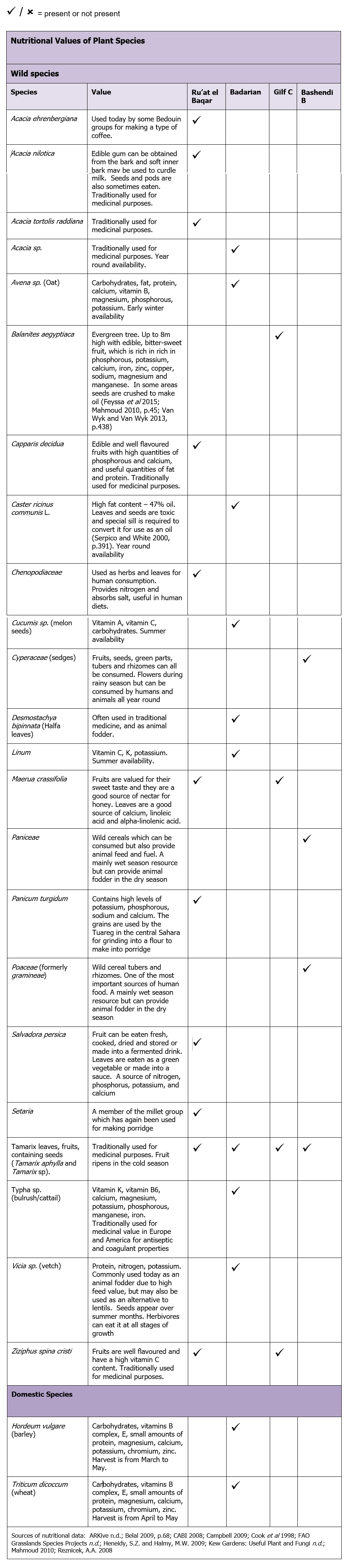 Table 9.4 – Nutritional Values of Plant Species
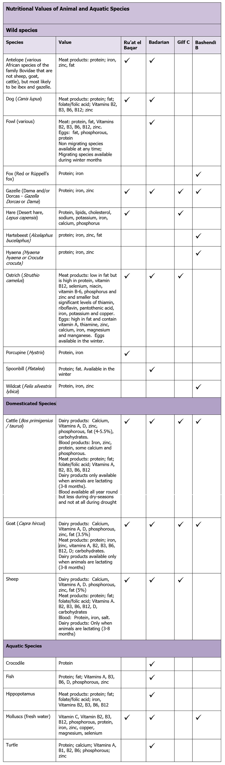 Table 9.5 – Nutritional Values of Animal Species
Tables 9.4 and 9.5 show the range of potential foodstuffs available in each area, some of which may also have been used for medicinal purposes. As one would expect, the Badarian had the most to offer communities because of the presence of riverine, floodplain, wadi and low desert resources. Elsewhere, there are two surprising omissions. The absence of sheep in Dakhleh may also have been due to poor preservation or the difficulties of distinguishing between some sheep and goat bones. Alternatively, sheep could have been judged to be in competition with cattle and therefore unsuitable. Desert hare seemed a surprising omission at Dakhleh, because it was desert-adapted, was found in the previous Bashendi A and was present in many mid-Holocene sites, where it seems to have been a staple of the diet (Pöllath 2009, p.94), making up 41.4% of the wild species in the Ru’at el-Baqar at Nabta (Gautier 2001), but is also only represented in small numbers at neighbouring Kharga oasis site KS43, where preservation of animal remains is good (Lesur et al 2011). Other than that, there are no surprises. The narrow range of animal and plant species actually represented is assumed to be due to poor preservation given the exposed palimpsest nature of sites.
The available data on plant and animal resources suggests that Badarian nutrition ought to have been suitable, with no significant shortages of vital nutrients, assuming that milk was consumed. Protein and fat was available from both domesticated and wild animal resources, as well as fish, whilst Zakrzewski’s analysis of dental remains indicates that large amounts of ground plant food, particularly cereals, were consumed. Having said that, Zakrzewski’s analysis of skeletal data suggests identified examples of stunted growth (Zakrzewski 2003, p.225), suggesting at least temporary periods of nutritional stress. It is impossible to compare this data directly with any of the other three case studies due to the absence of human remains for analysis in those areas, but it is a useful warning that data obtained from plant and animal remains gives only a very partial picture.
Dakhleh, with its bimodal weather regime and natural springs, supported species that were absent in the Gilf Kebir and Nabta Playa, including freshwater molluscs, hartebeest and plant species that favour standing water. With its varied topography Dakhleh potentially offered multiple different habitats for species to colonize, many of which could have been exploited, albeit by managing access right to water sources and leading very mobile lives. Depending on population levels and rainfall variability, there may have been periods of environmental stress and food shortage, difficult to alleviate except by concentrating on springs or temporarily leaving the area.
Nabta and Gilf Kebir occupations, both based on temporary rainfall lakes and pastures, were just as dependent upon the availability of water as in the Badari and Dakhleh regions, but less dependent on the availability of other resources due to the temporary duration of their presence in those areas before their return to more productive and sustainable environments. However, as emphasized in the Nabta case study, bone remains indicate that domesticates made up 85% of the diet (Gautier 2001, p.532) and the number of grinding stones implies extensive processing of wild grass seeds. Although superficially similar to Nabta in terms of temporary water supply, the data for Gilf C subsistence and nutrition is poor.
The skills and knowledge required for livelihood sustainability is traditionally passed from one generation to the next, as children learn from their older siblings and the previous generation. This is evident in the maintenance of industrial and cultural output throughout each of the periods under discussion, combined in each area to engage in overtly economic activities, supported at least in the cases of the Ru’at el Baqar, the Badarian and Gilf C by religious or ceremonial activities. Although many of the skills were easily transferrable, some technical tasks were more specialized, like the manufacture of very fine-walled pottery during the Badarian. More complex were the social and diplomatic skills required to engage in trade, such as the acquisition of exotic stones in Dakhleh and the Badarian, and knowledge of religion, rites and rituals that may have resulted in the Nabta ceremonial centre and the rock art at Gilf Kebir. In the case of all four case studies, Hunn’s definition of traditions as “the products of generations of intelligent reflection tested in the rigorous laboratory of survival” (1993, p.13) seems applicable.
9.2.3.6 Personal
The strongest opportunity for meeting these requirements seems to have been the Badarian. Individuality or recognition of the individual’s progress through life via rites of passage is suggested by ornamentation and the choice of grave goods. Status could have been expressed through access to exotic goods. There is also the possibility that glazed steatite belts were a badge of office for some members of the community. The least secure area, at least from the published data, seems to have been Dakhleh, where geographical constraint may have limited the expansion of population and limited the ability to secure status, although exotic stones may have been prestige items and the need to manage aquatic resources may have led to certain individuals becoming important in negotiations. The Ru’at el-Baqar and Gilf C seem to be fairly comparable, with the possibility of religious specialists mediating between the living and the supernatural, and at Nabta there is the possibility that the design and implementation of the ceremonial centre enabled certain people to influence outcomes and take on leadership roles, but which would have been subject to social and/or symbolic risks. In both cases a sense of security could have been engendered by social networks that could be used to facilitate a number of benefits.
9.2.3.7 Summary
The brief summaries above, derived from each case study, summarize potential points of strength and vulnerability in the asset mix and enable comparison. As described in the introduction to this section, the analysis is used to allocate qualitative scores to each of the asset components in each of the four case studies as follows in figure 9.3 in order to represent these areas of strength and weakness graphically and make them transparent.
 Figure 9.7 – Assigning values to the Asset Matrix
This enables the resulting strengths and weaknesses for all four case studies to be shown on a radar diagram for comparative purposes as follows in figures 9.4.and 9.5. Rather than just showing overall vulnerability, the radar diagrams help to demonstrate where problems with sustainability might lie in each of the areas represented by the case studies.
The result is four different patterns in table 9.4, combined in 9.5, highlighting that although some of the areas may have experienced similar levels of total vulnerability, there are 0considerable differences in where those vulnerabilities lie. Whilst there is real danger that interpretation of components has been skewed by differential survival of data, in most cases it has been possible to extrapolate from the data to a best-case scenario, as described in each case study. I have made it clear below where this has not been possible. It should also be noted that livelihoods will have responded to challenges on an annual or seasonal basis, so this represents a holistic representation of the situation, but does not incorporate variability on a seasonal or annual basis.
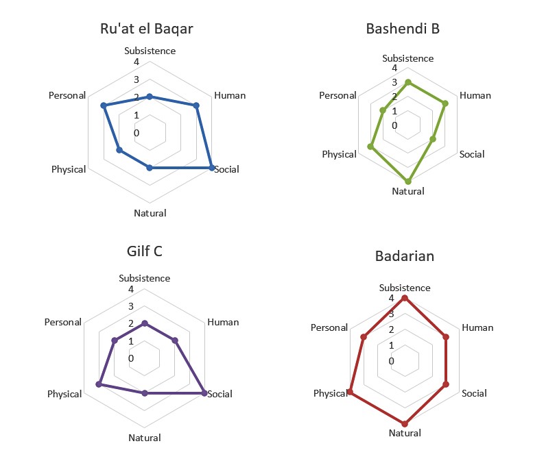 Figure 9.8 – Radar diagrams showing strengths and weaknesses
of each asset category
For comparative purposes they can also be seen on a single radar diagram as follows:
 Figure 9.9 – The combined radar diagrams of the archaeological case studies
The Badarian seems to have been generally well provisioned with no obvious points of weakness. Zakrzewski’s analysis of skeletal data suggests that some individuals experienced stunted growth (Zakrzewski 2003, p.225), and whilst this may be indicative of poor nutrition throughout the Badarian, it may have reflected an episode of several years or decades, perhaps caused by multiple failed Nile floods or disease amongst livestock. There does not seem to have been any reason why the area should not have supported people and their livestock sustainably. It may be surprising that the Social asset is rated low, because all the signs are that plenty of inter-group mechanisms including ideology, religious belief and traditions were at play to support households. However, inter-regional contacts cannot be demonstrated definitively, and it is possible that this would have been a serious weakness, leaving Badarian populations dependent upon their own internal support mechanisms without recourse to assistance from elsewhere.
The Ru’at el Baqar was generally strong in the main points where it mattered on the basis of a seasonal occupation. The main components that were important for a short stay were subsistence strategy and natural resources. Although the natural environment of the Ru’at El Baqar could not support extended human life, the objective of the visit was for water and pasture, and the wellbeing of herds are generally prioritized today over the wellbeing of herders. However, there will have been years of failed rainfall when Nabta was not viable, or when minimal rainfall led to much shorter visits than usual, and towards the end of the mid-Holocene these effects will have been exacerbated. Physical assets were sufficient for the needs of a limited stay, but raw materials for many of the tools were not available locally and had to be imported. Social assets, embedded mainly in the ceremonial centre and the traditions incorporated into ceramics, are very strong but the ceremonial centre may reflect a response to deteriorating climatic conditions, and could therefore be a marker of vulnerability.
The Gilf Kebir, like Nabta Playa, was inhabited on a seasonal basis, and part of its strength lies in the ability of inhabitants to occupy it when conditions were optimal for herds and to return to a richer and more reliable area when water and pasture were depleted. The main weaknesses were the temporary nature of the natural assets and the lack of ongoing nutrition, which will have been confined primarily to seasonal grasses and some perennial fruits. The main benefits of the Gilf were the value of water and pasture for herds and the ability to acquire raw materials on an ad hoc basis. As with the Ru’at El Baqar, activities based on religion and tradition seem to have supported the livelihood system but may also have been a response to difficulties such as environmental stress and conflict over territory. Whilst at Nabta it is possible that individuals were able to adopt roles of leadership and status during some activities, there are few signs of the individual in the Gilf C.
Although the archaeological record is ambivalent on the subject, it is difficult to imagine that the Bashendi B of Dakhleh was not rich in flora and fauna, with year-round water available, which would have supported the establishment of perennial plants that would have been beneficial for the development of soil. However, it was geographically constrained so for subsistence purposes it may have required a very strict livelihood management strategy, with both human and livestock populations placed under limits. The Personal asset has been rated fairly low because of the ephemeral nature of the sites and the possibility that population growth was limited by geographical boundaries. In addition, although it has been suggested by McDonald (1999; 2008 p.100, Table 1) that exotics may represent prestige items, there were probably few opportunities for individuals to contribute any extraordinary degree to either the community as a whole or to their own status. Bifacial tool technology and handmade pottery are both skilled crafts, but both can be learned from childhood and do not represent specialist technology, so are not indicators of specialist craft producers. However, although this shows as a dip on the radar diagram, there is no reason why it should have contributed to vulnerability.
It is interesting to compare this to the Hadendowa test study radar diagram shown in Appendix H and copied here in figure 9.6, showing the difference that modern government and non-government agencies make on livelihoods and options. Following the severe droughts of the 1980s, the expansion of urban centres, the introduction of agricultural schemes, the degradation of the natural environment and the intervention of aid agencies and NGOs, the radar profile captures an interesting situation. The Personal assets were high, due to opportunities for individual males in the urban centres, with NGOs and in agricultural schemes, at the same time giving more independence to women. Physical assets are also high, due to the low physical investment required for the Hadendowa livelihood. However, the declining condition of natural resources has a very negative impact on both economic and social assets. Aid agencies assisted with the immediate problem of food provision and put in place infrastructure to assist with human (health and education) and livelihood options, but the core values of the Hadendowa were under serious threat from the impact of these activities as well as the loss of adult males to wage labour in Port Sudan. The radar diagram captures the highly vulnerable situation in which the Hadendowa found themselves in the 1990s.
 Figure 9.10 – Radar diagram for the modern Hadendowa
9.2.4 Comparing the Key Questions
The key questions composed for the comparative study are as follows:
- What drew occupants into the area and why did they remain?
- What types of risk (natural and human) were experienced?
- What types of risk management strategies were employed?
- How can the economy be characterized?
- Are decisions identifiable in the archaeological record?
- How has group identity manifested itself in the archaeological record?
- Were opportunities taken up in times of insecurity or stability?
- Can the livelihood be characterized as sustainable?
- What were the drivers for significant change at the end of each period?
9.2.4.1 What drew occupants into the area and why did they remain?
In all of the case studies, the main driver to occupation was hydrology – the availability of water on a seasonal or year-round basis. There may have been other incentives, including competition for land elsewhere, but these are not visible in the archaeological record. Traditional affinity with the area, which would fit the Nabta and Gilf data, or continuity of occupation, as in Dakhleh, are other explanations. Dakhleh was the only desert area that may have had sufficient hydrological resources for year-round occupation. At Gilf Kebir and Nabta rainfall was highly seasonal representing an opportunity to rest dryland resources and maximize the opportunities offered by these temporary refuges. The Badarian was located on the Nile. Another factor in most areas, with the possible exception of Nabta Playa, was topographical variability, meaning that there were different types of environment to exploit for potential grazing, wildlife and the acquisition of material resources.
9.2.4.2 What types of risk (natural and human) were experienced?
Risk has been discussed in each case study and has been compared in detail above in 9.2.1 and will not be repeated here. As indicated, risk management employed economic, social and symbolic mechanisms, as part of livelihood management strategies where risk management was an integral part of the livelihood. Each of the areas experienced a different set of risks and different approaches to risk management were deployed.
9.2.4.3 What types of risk management strategies were employed?
This question has also been addressed in 9.2.1, but a number of themes can be isolated for comment. Mobility was necessary to all four areas, although they were different forms of mobility. Whereas Dakhleh groups were probably highly mobile, Badarian groups were only forced to abandon floodplains on a seasonal basis due to the annual Nile flood whilst, by contrast, the Gilf and Nabta were only attractive on a seasonal basis. All economies were diversified. The combination of mobility and diversification suggests in all cases similar concerns with habitat management, but all differed in their implementation. Ideological and religious beliefs suggest an investment in symbolic means of risk management in all cases except Dakhleh, where there are no unambiguous indicators. Social and exchange networks are implied in all case studies, although how they operated is completely opaque. When environmental conditions began to undermine livelihood strategies and people had to make choices about how to respond, only Dakhleh and the Badarian areas could support ongoing occupation, and in the case of Dakhleh those who stayed to live in impoverished conditions. Nabta and the Gilf Kebir were abandoned.
9.2.4.4 How can the economy be characterized?
All three desert livelihoods were based on diversified pastoralism, some degree of mobility to spread the load on the landscape, and plant foraging. At Gilf Kebir different sized groups, possibly specialized work and foraging groups, appear to have split off from the main camps to different parts of the landscape for short periods. The finds at Safsaf (Close 1996, 2002a) may suggest something similar for Nabta, but may also be evidence of a completely unrelated activity. Dakhleh appeared to lack sheep, but that might be a bias in the survival of the data. The Badarian population had access to fish and riverside vegetation, which would have been unavailable at Dakhleh or Gilf Kebir. Nabta ceramics show strong affinities to sites on the Nile which may indicate that Nabta occupants had access to riverine resources for parts of the year when they were there. At least some of the Badarian groups may have cultivated crops imported from the Near East. Exchange, difficult to observe, probably formed part of a network of supply and demand, but it is very opaque. Some signs of storage have been suggested by minimal data everywhere except Gilf Kebir, but it is again nebulous.
9.2.4.5 Are decisions identifiable in the archaeological record?
Whilst realizing that the palimpsest character of the data would complicate the question of whether decisions are visible in the archaeological data in the four areas, it was still of interest. Decisions can be broadly categorized as individual (where the efforts of one person can be observed), household or group. Table 9.6 below suggests some of the decisions that take place in this areas. It emphasizes that some important Segal (1994) emphasizes that risk is a constant process of problem solving and decision making, and that this is captured in decisions such as when and where to move during the seasonal round might take place at either the group or household level, whereas others, like repairing broken pots or manufacturing and curating high-cost bifacial tools in specific forms, are in the realm of the individual. Ceramics in the areas of the case studies are probably manufactured on a household basis as there are no signs of centralized industrial areas. Motivation for these decisions may, of course, lie elsewhere. For example, although bifacial tools are manufactured on an individual basis, their purpose may serve the group as a whole in the form of expressing group identity or regional affiliation (see table 9.10). Some decisions may be on behalf of the group but made by an individual, for example the location and execution of rock art or the activities that take place in the ceremonial centre, but as this decision-making process is unknown, both are situated in the Group column as they represent decisions that are made on behalf of the group.
 Table 9.6 – Suggested group sectors in which decisions may be visible
At a group level, the ceremonial centre at Nabta represents a series of decisions to make certain monuments, decisions about what forms they took and choices about how and when to use them. Similarly, the placement of new cemeteries in the Badarian and who was interred within them must have involved discussion and choices. At both Gilf Kebir and Nabta the decisions about when to mobilize people and herds may have been made on a household or group level. The Badarian site of Mahgar Dendera provides evidence of a range of decisions. Unlike the core Badarian sites, this was a specialized occupation, representing choices about when to move, where to move, which livestock to take and what sort of toolkit was necessary.
As well as these broad observations, micro-decisions can be identified. In the Badarian the mending of broken pottery was a decision to curate an item rather than replace it. At Dakhleh the production of labour-intensive bifaces involved a whole series of decisions about the final form of the object and the best way to achieve it. At the Gilf Kebir, rock art represents decisions about composition, features to include or exclude, and the precise execution of the paintwork. Individual scenes or at least individual components were executed by individuals to produces unique scenes and depict individual animals. The decisions that went into the execution were subsumed into their function, combining group impetus with individual skills. In the Badarian, the grave goods that accompanied the dead were clearly a matter of choice, although who made those choices is unknown. Each grave was unique, each person accessorised in a unique way either due to a) their own preferences or ability to secure items, b) the requirements and means of the bereaved or other interested parties, or c) the dictates of an invisible formula.
9.2.4.6 How has group identity manifested itself in the archaeological record?
Group identity has been defined in the glossary (Appendix A) as any set of characteristics that suggest not only a common identity but also the desire to express that identity. Throughout the case studies cultural output has been discussed as having a specific function as a cohesive force. Table 9.10 suggests some levels at which identity might be deliberately displayed at the individual, group and regional levels.
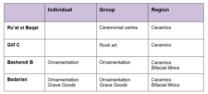 Table 9.7 – Suggested group sectors in which identity may be expressed
The best case for group identity expressed in the archaeological record is the Badarian, where fine ceramics and individual ornamentation are defining characteristics of the community and how it perceived and expressed itself. Items in graves may suggest that this sense of group and personal identity extends into whatever lay beyond death. At the very least, it is suggestive of how people negotiated the complexities of life via cultural media. At Dakhleh too, albeit to a much lesser extent, items of personal ornamentation were found. The carefully composed rock art at the Gilf Kebir is associated not with individuals but places, usually hidden, and its themes suggest that the identity of people was closely tied to their relationships with herds in a way recently explored by a number of writers (e.g. Dittrich 2017; Oma 2010; Orton 2010; Russell 2010; Sykes 2014). In all areas the distinctive character of the ceramics may have been produced to a basic regional pattern book of styles both linking dispersed groups and differentiating them from communities from other areas. This tripartite view of identity is simplified but does demonstrate that it can operate on multiple scales.
9.2.4.7 Were opportunities taken up in times of insecurity or stability?
As discussed in Chapter 2 and illustrated in Appendix D opportunity potentially offers something both new and possibly improved, but may simultaneously represent risk, both economic and social. In Nabta, Dakhleh and the Gilf Kebir, small numbers of domesticates were introduced in the Ru’at el Ghanam Middle Neolithic, Late Bashendi A and Gilf B respectively, incorporated into a livelihood strategy significantly dominated by hunting and foraging. It was only as climate and environment became significantly different over time that domesticates became the dominant element in subsistence strategies. At Dakhleh a new approach to subsistence was apparently built on existing resources. People now consumed the meat of domestic species for the first time, rather than using them for their exclusively for renewable products. At Gilf a new style of ceramics is accompanied by a new style of rock art, and domesticates become central to the livelihood strategy. Changing climatic conditions altered the rainfall regime and the environment in a way that favoured herding, and at the same time, cultural output seems to have reflected the change in livelihood management. This suggests that at Gilf group identity changed in response to the instability of a changing environment and the opportunity offered by pastoral herds. At Nabta the absence of information about where the Nabta occupants came from hinders any discussion, but the innovation and elaboration of the ceremonial centre coincides with climatic deterioration, suggesting a response to increasingly difficult conditions, the undermining of a way of life. The Badarian is the most difficult to assess. It emerges in Middle Egypt, with a material culture that shares most affinities with those in the Sudan. If this indicates a breakaway group that moved north, it implies that the social and symbolic identity of the group remained intact, whilst conditions in the originating area incentivized migration north. In these case studies my conclusion is that opportunity, in this case the adoption of domesticates, occurs under conditions of relative stability, where routines and traditions are well established and livelihoods have been sustained for many generations, but that intensification is driven by a perceived need to modify livelihoods to make them more resilient against environmental deterioration.
9.2.4.8 Can the livelihood be characterized as sustainable?
Sustainability turns out to be rather less useful as a concept and tool for measuring livelihood adaptability that I anticipated. In a sense, all of the case studies suggested that the livelihoods identified in the archaeological record were sustainable, simply because they lasted for such a long time. In the three desert case studies the livelihoods only became unsustainable when climate changed. Because there is no granular information about how well these livelihood strategies worked out on year to year basis within any of the case studies, any real measures of success or failure are impossible to find.
9.2.4.9 What were the drivers for significant change at the end of each period?
No innovation would have enabled rain-fed areas like Nabta and Gilf Kebir to have survived the climatic downturn. Migration was the only viable solution. It is unknown where the Nabta occupants were based, but it is most likely that they moved on a permanent base to the Nile valley. Gilf Kebir occupants probably moved south to Laqiya, some 400km away (Kuper 2007, p.9). Dakhleh Oasis was never abandoned completely, but the Bashendi B groups appear to have left when rainfall led to drying of the plateau, plains and wadis. They left behind the Sheikh Muftah groups whose material and skeletal remains produced signs of a very impoverished livelihood strategy. The Badarian region was not abandoned, but there are indications that people dispersed, mainly to the south, innovating economically and culturally to achieve a new way of life based on mixed agriculture that is labelled Naqada I. Why this dispersal took place after so long is unknown.
Perhaps the most useful conclusion is that when abandonment took place, it only occurred as a result of uncertainty. Up until that point risk management strategies had been able to sustain groups in increasingly difficult marginal conditions.
9.3 Conclusion
In this section I have isolated certain aspects of livelihood management to compare across the case studies to demonstrate that as well as using the SRL model to build up a comprehensive view of archaeological data in a given area, it is also possible to use the SRL format to ask specific questions of the data, and to compare that data across geographical areas. This was time-consuming and it was impossible to compare all the components in the SRL model. I also believe that the key questions, whilst potentially useful as a comparative device, could have been better chosen.
Perhaps the most useful aspect of the chapter was the potential for taking reaserch forward. For example, the comparison of total vulnerability and assessing the individual strengths and weaknesses in each asset matrix using the radar diagram. This workstream made it was possible to bring out areas of investment that would have needed to be made by each individual community in order to ensure survival. Where the solution was abandonment rather than the very high risk strategy of trying to manage uncertainty, the findings suggest future lines for research into alterative migratory destinations for households or larger migratory groups, and the livelihood changes that were made in order for these migrants to establish themselves in new areas. Similarly, some of the key questions could themselves form the basis for hypotheses to be tested in future research.
I believe that this chapter has demonstrated that the SRL model has the potential to be a very good tool for comparing livelihoods, the risks that communites might have faced at the end of the mid Holocene and their vulnerability to existing and future problems. In addition, the findings indicate that the approach can be used to generate future research questions about regional change.
