Before reading this case study
Before reading this case study it is strongly recommended that you read Chapters 1 (introduction, which introduces the SRL approach and discusses how the ethnographic data is used in the case studies), 2 (detailed explanation of the modelling approach), 5 (ethnographic research that informed the case studies), the relevant bits of 6 (background information to the case studies, including excavation history and notes about chronology), and 7 (the SRL template) all of which are essential to an understanding of how the case studies were compiled and what they are designed to achieve. The case studies were never designed to be read as stand-alone pieces. Chapter 9 compares the case studies, and may be of interest to those who are interested in different approaches to livelihood management in dryland areas.
As explained within the thesis, my priority was to test the Sustainable Rural Livelihood model, which was derived from development economics. This means that the emphasis was on pushing the data to the absolute limit. This has resulted in speculative scenarios that match the data, many of which are by no means the only possible explanations and are open to challenge. I believe, however, that some speculation is a healthy move towards the creation of hypotheses that can be tested rather more empirically, and hope that the speculative relationship between the published data and my speculative extrapolations is made explicit.
You can read and print the case study from this page, but you can also download it as a PDF here.
1.0 Introduction
The following section discusses the Gilf C period of the Gilf Kebir, within the framework of the Sustainable Rural Livelihood approach and is divided into the sections described in Chapter 7. An introduction to the case study is provided in Chapter 6. The Gilf Kebir is located 650km to the west of the Nile, on the same latitude as Late Nasser (figure 1), close to the Libyan border with Egypt. Preceding the Gilf C, the Gilf B lasts from c.6800BC to 4300BC (Linstädter 2005g, p.361), and is split into a Gilf B1 and Gilf B2, with the latter beginning at c.5500BC. The beginning of Gilf C is not easy to isolate as it lies in a dense multi-period occupation consisting of palimpsests in the Wadi el-Akhdar (figure 2), but it is thought to lie at c.4300 and it ends at around 3800 BC with the breaching of the dune barrier at Wadi el-Bakht (Linstädter 2005g, p.364). It was followed later by the Gilf D, which is thought to have lasted between 3300 and 2700BC (Gehlen et al 2002; Linstädter 2005g, p.366).
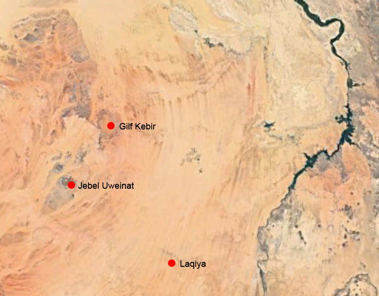 Figure 1 – Location of the Gilf Kebir, also showing the
Jebel Uweinat and Laqiya (Source: Google Earth)
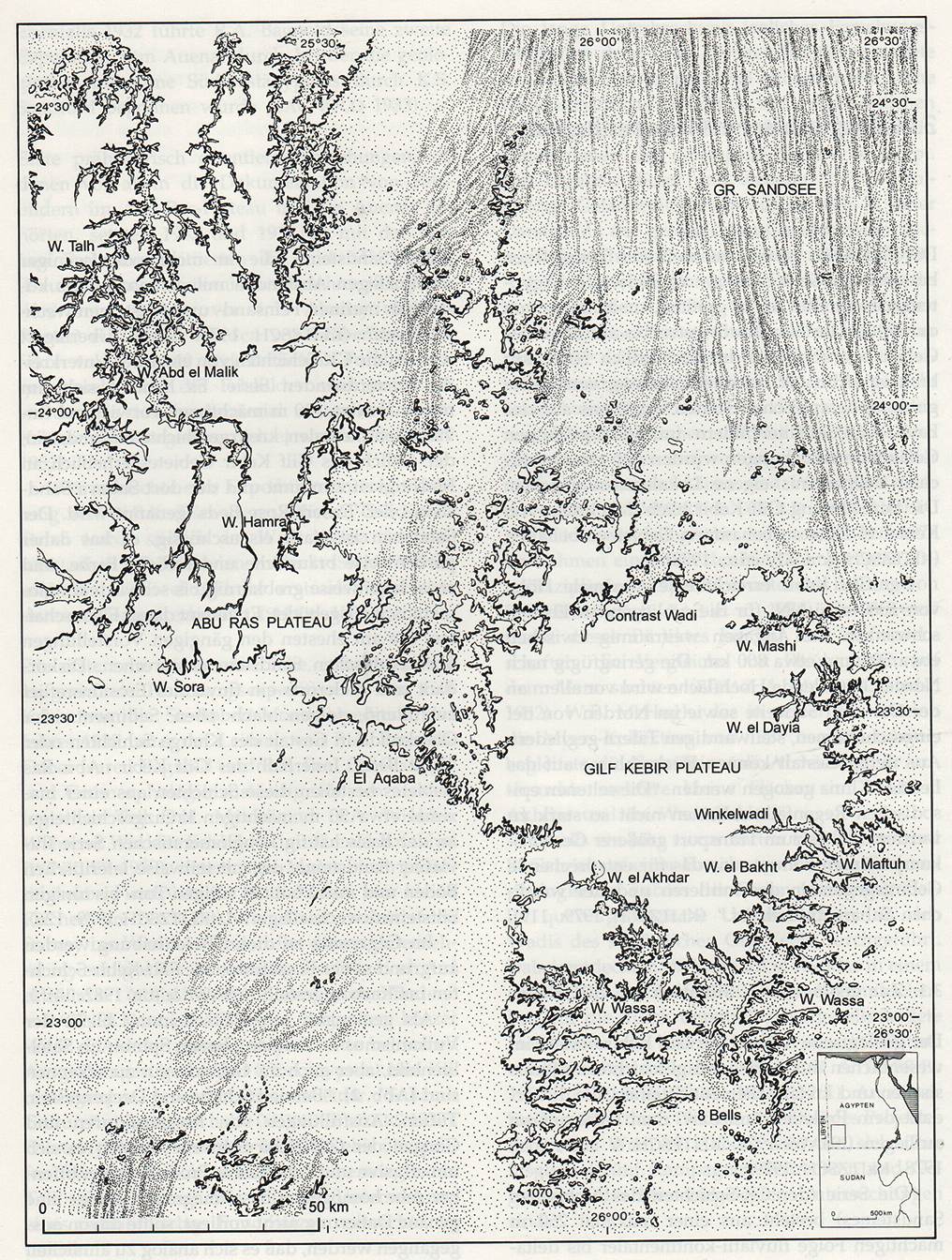 Figure 2 – Map of the Gilf Kebir, with individual wadis named.
(Source: Schön 1996, p.20)
2.0 The data available for each phase
The available datasets are summarized in table 1, below.
Yes=Present / No= Not present
| Category | Data | Yes/No |
| Site type | Settlement | Yes |
| Cemetery (concentration of multiple burials) | No | |
| Ceremonial (monuments and ritual structures) | No | |
| Unknown | – | |
| Architecture | Domestic shelters / foundations | Yes |
| Hearths / Steinplätze | Yes | |
| Storage | No | |
| Ceremonial structures | No | |
| Type | Stratified | No |
| Palimpsest / Chronologically undetermined | Yes | |
| Cave / rock shelter | Yes | |
| Funerary | Burial structures | No |
| Human physical remains | No | |
| Grave goods | No | |
| Diet | Faunal remains | Few |
| Botanical remains | Few | |
| Environment | Faunal remains | Few |
| Botanical remains | Few | |
| Sedimentary and geomorphological data | Yes | |
| Other environmental / climatic indicators | Yes | |
| Tools/ Craft items | Stone tools | Yes |
| Grinding stones | Yes | |
| Pottery | Yes | |
| Ostrich eggshell | Yes | |
| Basketry, cordage etc. | No | |
| Animal products | No | |
| Other artefact types | No | |
| Personal or symbolic material | Beads / other jewellery | Rare |
| Portable art | No | |
| Palettes | No | |
| Cultural components on everyday tools / pottery | Yes | |
| Rock art | Yes | |
| Prestige objects | No | |
| Dating | Radiocarbon dates | Yes |
| Relative / stylistic | Yes |
Table 2 lists sites mentioned in the text, and table 3 provides a list of radiocarbon dates for Gilf C.
| Site | Type of site | Key features |
| 00/73 | Occupation | Plateau site |
| 00/74 | Occupation | Plateau site with small inventory |
| 00/9 | Occupation | Surface scatters with remains of Gilf C type flakes artefacts in Wadi Hamra |
| 09/101 | Rock art | Cattle Herder style site, engraved, one animal carrying what appears to be a large sack. |
| 99/50 | Occupation | Plateau site with small inventory |
| 99/51 | Occupation | Plateau site |
| 99/53 | Occupation | Plateau site with small inventory |
| Wadi Sura I | Rock art | Small niche to east of Cave of Swimmers with Cattle Herder style paintings |
| Wadi Sura II (also known as 09/2) | Occupation and rock art | Extensive panel of Gilf B rock art with some earlier and later pieces. Occupation debris dominated by Gilf B but with some Gilf C lithics and ceramics. |
| WEA 81/4 | Occupation | Amongst oldest of the Gilf C sites. Surface scatter over area 10x15m in Wadi el-Akhdar with remains of a hearth and large concentration of artefacts |
| WEA 81/41 | Occupation | Amongst oldest of the Gilf C sites. In Wadi el-Akhdar. |
| WEB 82/13 | Blocking dune and occupation | Breached blocking dune in Wadi el-Bakht, providing essential information about environment, chronology and occupation |
| WEB 82/15 | Occupation | Artefact concentration with 7 blanks per square metre and findings of sheep, goat and possible cattle |
| WEB 82/17 | Occupation | Includes 512 pottery fragments |
| WEB 82/18 | Occupation | Surface and sub-surface remains with a hearth/pottery kiln |
| WEB 82/19 | Occupation | Surface and sub-surface remains with a hearth |
| WEB 82/22 | Occupation | Surface scatter with remains of domesticated cattle |
| WEB 82/24 | Occupation | Artefact concentration with 15 blanks per square metre |
| WG35 (formerly WS47, also known as 09/22) | Rock art | Painted and engraved rock shelter on a very low ceiling 60-80cm from the rocky ground. More than 158 individual figures on a panel 5m2. |
| WG61 | Rock art | Depiction of cow with oversized udders |
Table 2 – Gilf C Neolithic sites mentioned in the text
The radiocarbon dates in table 3 below, both calibrated and uncalibrated are all taken from publications. Whilst I calibrated uncalibrated dates myself in other case studies, in the case of the Gilf Kebir publications, most of them did not provide uncalibrated dates and some failed to provide laboratory numbers. It seemed best, therefore, to use the calibrated dates used within the publications. Where no laboratory number was provided in the publication, the source has been listed instead.
| Uncalibrated c-14 dates bp
|
Calibrated dates BC
* |
Lab. No./Ref | Site/Feature |
| 5405±75 | 4210±110 | Erl-2873 | Wadi el-Bakht 82/13 |
| 4880±390 | 3590±480 | KN-3182 | Wadi el-Bakht 82/13 |
| 4820±60 | 3590±70 | KN-3098 | Wadi el-Bakht 82/13 |
| 4770±130 | 3530±140 | KN-3184 | Wadi el-Bakht 82/13 |
| Unknown | 4010±81 | von Czerniewicz 2005 | Wadi el-Bakht 82/15 |
| Unknown | 3874±71 | von Czerniewicz 2005 | Wadi el-Bakht 82/24 |
| Unknown | 3866±70 | von Czerniewicz 2005 | Wadi el-Bakht 82/15 |
| Unknown | 3703±55 | von Czerniewicz 2005 | Wadi el-Bakht 82/24 |
| Unknown | 3594±476 | Linstädter 2005f | Wadi el-Bakht 82/19 |
| Unknown | 3529±142 | Linstädter 2005f | Wadi el-Bakht 82/19 |
Table 3 – Gilf C Radiocarbon Dates.
3.0 The Livelihood Status
3.1 Asset Matrix
3.1.1 Natural Assets
Table 4 summarizes the main types of zone available for exploitation during the Late Neolithic Ru’at el Baqar, with zones unavailable shown greyed out and crossed through:
| Zone 1 | Sahel type / savannah conditions | Light seasonal rains produce a savannah and scrub type ecology similar to the modern day Sahel, with grassland and shrubs suitable for seasonal but not necessarily year-round herding |
| Zone 2 | Highlands, low hills, escarpments, Plateaus | Seasonal vegetation, attracting certain vegetation and game, sometimes offering different topologies and ecological niches |
| Zone 3 | Riverine | Permanent water source with floodplains, attracting vegetation, game and containing aquatic resources |
| Zone 4 | Lake / Playa / spring | With the potential for aquatic plants but not fish or other zoological species |
| Zone 5 | Groundwater zone
|
Runs along the edge of water-filled basins and supports seasonal vegetation, attracting game on a temporary or permanent basis |
Topography
The Gilf Kebir is a dissected plateau consisting of two plateaus connected by a small land bridge, covering an area of c.90,000km2 (Linstädter 2007, p.20). The northern-western plateau is the Abu Ras plateau approximately 140km north to south and 40km east to west, the larger southern one is named the Kemal el-Din or Gilf Kebir plateau, approximately 120km north to south and 80km east to west (figure 2). Gilf C remains are largely found in the southern plateau in the east, with only ephemeral remains found from the northern section (Kuper et al 2009, p.8). Both plateaus are dissected at their edges by a fringe of dried valleys which, in the past, channeled surface run-off and reach lengths of up to 20km long and 4km wide (Linstädter and Kröpelin 2004), mainly extending from west to east on the southern plateau and south to north on the northern plateau. At its greatest height the plateau reaches 300m, 1100m a.s.l., with frequent pediments at its feet, surrounded by peneplains covered with immense bodies of sand (Darius 2013, p.70) (figure 3).
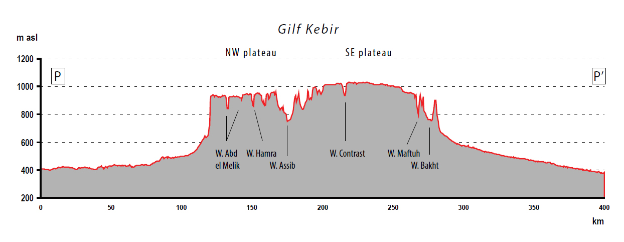 Figure 3 – Altitudinal profile through the Gilf Kebir, north to south.
(Source: Darius 2013, p.71, figure 4).
The wadis (dried river valleys) that channeled rainfall episodes attracted vegetation and wildlife, and in their wake, people. The longest wadis, at the southern and southeastern edges of the Kemal el Din plateau, extend from west to east, reach up to 20km in length and 4km wide, and are very steep with several box-type canyons with abrupt heads (Kröpelin 2005, p.52). Wadi Maftuh, Wadi el-Akhdar and Wadi el-Bakht were blocked by sand dunes during the early and mid-Holocene. Wadi el-Akhdar and Wadi el-Bakht were used by groups of hunters during the early and mid-Holocene, and were breached at the end of the mid-Holocene (Linstädter 2005; Schön 1996). An analysis of Wadi el-Bakht 82/13, where the dune sands cross the wadi 19km about the wadi mouth, shows that the dune was formed of sands from the Great Sand Sea to the north (Linstädter and Kröpelin 2004). The breach dates to c.3800BC and reveals sediments 8m thick with playa silts over an area of 6600m2 (Linstädter 2005g, p.364). Wadis on the northwest plateau, where much less Gilf C occupation material has been found, are short by comparison, but form steep cliffs.
The Gilf, dipping towards the north, consists of three main layers lying within a broad plain. At the base is a layer of Precambrian igneous and metamorphic rock knows as the basement complex (Issawi 1980; Sampsell 2003, p.17). Overlying it is a layer of variegated Palaeozoic sandstone topped with c.250m of Jurassic and Cretaceous Nubian sandstone and then hard silicified components including shales and quartzitic beds (Bagnold 1939; Issawi 1980; Schön 1996). The surface is covered with hamada and wind-blown sand, and basalt, extruded from fissures, forms shiny black sheets. The plateau, which is remarkably level, dips from south to north. A schematic of the geology of Jebel Uwenat and the Gilf Kebir are shown in figure 4.
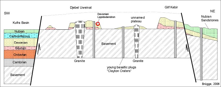 Figure 4 – Geology of the Jebel Uweinat and Gilf Kebir area (Source: Brügge 2006)
The Gilf Kebir is connected to Jebel Uweinat by a stretch of terrain that rises above the surrounding plain, making the Gilf Kebir the northern terminus of a highland chain (Darius 2013, p.17-7). Figure 5 shows the relationship between the Gilf Kebir and Jebel Uweinat.
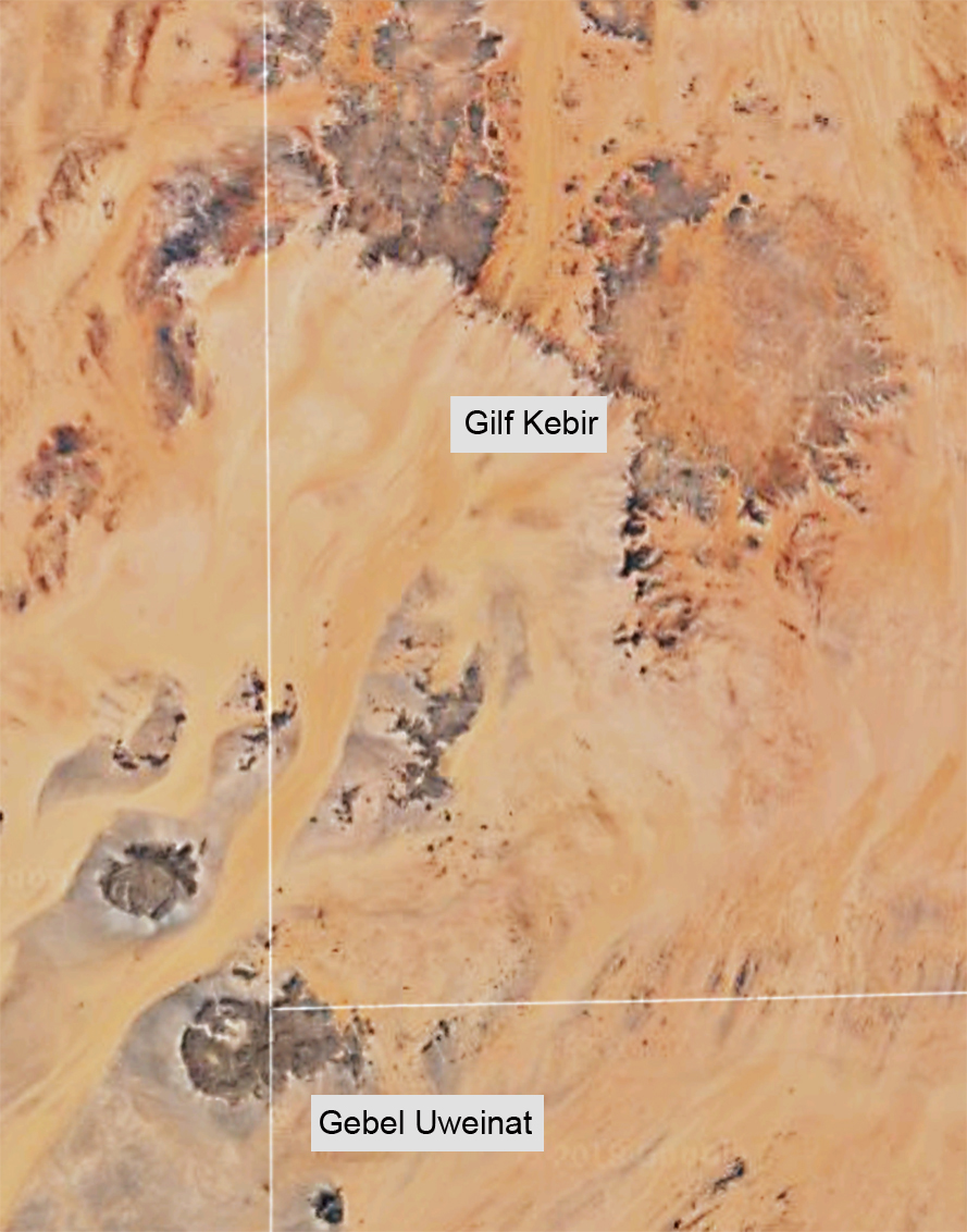 Figure 5 – The Gilf Kebir and its relationship to
Jebel Uweinat, showing the borders between Egypt, Libya
and the Sudan (Source: Google Maps)
Hydrology
The climate conditions of the Early Holocene changed in the Mid-Holocene, rendering many desert areas uninhabitable (Nicoll 2004, p.569). The Selima lake to the east, which may have been a resource during the early Holocene, also began to evaporate, reaching a peak of evaporation between during the mid-Holocene, forming a saline lake that could only be used as an unpredictable seasonal pasture during the Late Neolithic (Schuck 1993). Oyo became saline and various rainwater playas had desiccated either partly or completely by the end of the mid-Holocene (Nicoll 2004, p.570). The Intertropical Convergence Zone (ITCZ) shifted south, changing the rainfall conditions of the Gilf Kebir area and, as from 4210±110yrBC (Linstädter and Kröpelin 2004, p.760), it is thought that a change from African monsoonal conditions to a Mediterranean climate “took place with quantitatively lower amounts, but more continuous winter rainfall.” Gilf C was characterized by less violent but long-lasting rains than in Gilf B, which speaks for a more Mediterranean controlled winter rainfall regime, with rain failing mostly at night, and distinguished by much lower run-off than in the Gilf B monsoonal regime (Linstädter 2005g, p.367). The lower evaporation and higher absorption rates enabled by night-time winter rainfall and lower run-off were critical factors for the establishment and sustainability of vegetation. (Linstädter and Kröpelin 2004, p.774). Rainfall is estimated to have amounted to no more than c.100-150mm per annum (Linstädter and Kröpelin 2004, p.763). Throughout the mid-Holocene, the desert conditions were probably increasingly unreliable from one year to the next, with the presence of different lakes and smaller basins becoming unpredictable. The Nubian aquifer, which over lies over the Basement Complex and beneath the Western Desert, continued to provide perennial water to the depressions of Dakhleh and Kharga to the north, and appears in a small number of springs in the Jebel Uweinat 100km to the south, but does not reach the surface at the Gilf Kebir.
Although the annual volume was actually less than during the early Holocene, and may have been in the form of short and violent bursts (Von Cziernewicz 2005, p.213), the rainfall is thought to have fallen at night, when evaporation levels were weaker, and absorption rates were better. At the same time, rainfall was more evenly distributed throughout the year, and experienced lower run-off rates, meaning that total annual rainfall was less important than when it fell and the impact it had on the environment, which resulted in grasslands on the plateaus (Linstädter and Kröpelin 2004, p.774). The effect of this is thought to have been an improvement of conditions on the plateau, which produced pasture.
The dominant hydrological feature of the Gilf C occupation is the presence of playa lakes in three southwestern wadis, Wadi el-Akhdar (Green Valley), Wadki el-Bakht (Valley of Chance/Luck) and Wadi Muftah (Open Valley), trapped behind retaining barrier dunes (figure 6) (Kröpelin 1989; Schön 1996; Linstädter 2005), which were formed from Great Sand Sea sands and transported by Northerly trade winds (Kröpelin 2005). The lake strata indicate “short-lived rainpools containing water for weeks or months at most” and it was thought that these were drained by breaches in the retaining dunes caused by heavy rainfalls towards the end of the mid-Holocene (Kröpelin 1993a, p.250-52). Sediments consistent of thin alternating layers of mud and sands (Linstädter and Kröpelin 2004, p.757). Excavation of the Wadi el-Bakht dune barrier at 82/13 revealed sediments of up to 8 thick, covering an area of 6600m2 (Linstädter and Kröpelin 2004, p.757). There was no groundwater was available outside the wet season, although the water table would have been accessible at such times (Schön 1996, p.127) and there was little permanent plant, fauna and no fish were associated with the temporary dune barrier lakes.
 Figure 6 – The remains of the dune barrier across the Wadi Bakht
(Source: Gehlen et al 2002, p.103, figure 15).
The much smaller wadis of the northwestern Abu Ras plateau, which lacked dune barriers, may have benefitted from endorheic basins at their bases (Kuper et al 2011), These may have accumulated, as suggested by Peel (1939, p.306) by rainfall percolating through porous Gilf stones and channelling to the base of the plateau. These small wadis with far more ephemeral pools were more vulnerable to drought conditions than the deep eastern wadis. Gueltas are to be found in most parts of the Gilf Kebir, faults and caverns where rain percolated and was collected (Darius 2013, p.17; Riemer and Kuper 2012, p.113).
The northern edges of the Abu Ras plateau blend into the Great Sand Sea, which had been dotted with hunter gatherer camps during the early Holocene, and were almost all abandoned during the early mid-Holocene (McHugh 1974; Riemer 2005). Willmann’s Camp, a site to the north of Gilf Kebir, may have been employed by groups belonging to Gilf B or C, or both. The site lies on a massive palaeodrainage system with water draining from the Abu Ras plateau to the east and accumulating in a dune corridor (Bolten and Bubenzer 2007).
At least three wadi dune lakes formed in Wadi el-Akhdar and Wadi el-Bakht and Wadi Maftuh in the southeastern Gilf Kebir (Linstädter and Kröpelin 2004). Jebel Uweinat to the south benefited from springs, orographic rainfall and groundwater in wadis/karkurs that was replenished by rainfall (Darius 2013). Rain still falls occasionally today, and the remarkable impact on vegetation can be seen on Zboray’s web page about the aftermath of rainfall in 2005 and subsequent years (Zboray n.d.).
The importance of the dune barrier is emphasised by the end of occupation first in the Wadi el-Akhdar and later in the Wadi el-Bakht, when each dune was breached, probably as a result of a flash flood putting unprecedented pressure on each of the dunes in turn (Linstädter 2005g, p.364).
It has already been seen how modern pastoralists are highly sensitive to localized conditions (Chapter 5) and how mobility is one of many strategies used to handle it. The hydrology of the Gilf Kebir area alone, without other considerations, would have required movement between different areas on a seasonal and perhaps more frequent basis, including several nodes and routes between them.
Light and temperature
Egypt has a high light and temperature quotient throughout the year. The lowest mean annual temperature at Luxor is 13°C in January, the highest 32°C in July and August (Ibrahim and Ibrahim 2003). Night time temperatures are considerably lower, particularly on the plateaux, which can be near freezing at night in winter (Siliotti 2009, p.13), and in the deserts flanking the valley, but not to the point of being detrimental to livelihood options. The conditions of high heat and little shade will, however, have constrained forms of vegetation and fauna that can survive in the desert.
Aeolian conditions
The prevailing winds in Egypt are north-eastern trade winds which, in winter are interrupted by west north-western winds from the Atlantic. From February to the end of April the hot dry dust storms called the khamsim (“50-day wind”) are common (Ibrahim and Ibrahim 2003, p.52; Silotti 2009, p.13), and sweep across the plains of the southern Western Desert, visibly picking up, shifting and redepositing loose surface particles in great dust clouds that move at considerable speed. In the Gilf Kebir area aeolian activity has had considerable impact on desert, with wind from the north creating hamada surfaces on the plateau and driving the Great Sand Sea over the northern edges of the plateau.
Aeolian action has resulted in the removal of the top layers of settlement material, leaving behind palimpsests of geological and archaeological material, much of it highly weathered.
Edaphic Conditions
Ibrahim and Ibrahim (2003, p.52-3) describe soils in Egypt as aridisols in the desert areas and sandy-rocky desert surfaces having low humus content with little biological activity and coarse to medium texture. Today annual seeds of desert adapted vegetation regenerate after water, but only sparsely in the nearly sterile soils of the desert. Due to the extreme aridity, the oil is vulnerable to aeolian action and there is little topsoil, meaning that there is a lack of essential nutrients for plant growth, particularly nitrogen and phosphorous.
The soil quality of the Gilf area continued to be relatively poor but probably improved during the Mid-Holocene. The patterns of precipitation are thought to have varied by both diurnally and in duration. Lighter but more regular rainfall, falling at night time with lower evaporation and higher absorption rates (Linstädter and Kröpelin 2004) will have led to some soil formation and the possibility of the establishment of more robust vegetation with healthier root systems, particularly around pools of water (Kröpelin 2005, p.59). The soils in the valleys, derived from fluvial sands and pelitic playa deposits were less suitable for water absorption and the growth of pasture than the orthitic solonchaks and pelitic playa deposits of the valley floors (Alaily 1993; Linstädter and Kröpelin 2004). The playa deposits themselves consist of sandy material with a high clay content (Neumann 1989, p.120).
Settlement sites, which are found on the plateau in the mid-Holocene period, support this pattern of hydrological change and soil formation. As the quality of the soil support vegetation directly impacts the nutrients available to grazing animals, the plateau resources would have been beneficial to both wild and domesticated animals. The northern Gilf has been broken down by these aeolian processes into inselbergs and cones whilst much of the northern plateau is now hamada. The southern plateau is more forgiving with large stretches of sandy surfaces which even today turn green after the infrequent rainfall (see, for example, Zboray n.d.).
Vegetation
Today the Gilf receives less than 2mm winter rainfall per annum (Darius 2013; Kröpelin 2005, p.51). In a recent study, Darius found 7000 trees, some over 10m tall (Darius 213, p.72). They are dominated by Acacia ehrenbergiana and Acacia tortilis raddiana. Less drought tolerant Maerua is much less common, with Zilla spinosa beneath, and Balanites is rare but present. In the southern Gilf Tamarix is dominant today, with less frequent examples of Ziziphus, Acacia, Faidherbia albida and Maerua crassifolia. In less well watered parts of the Gilf the only vegetation observed are those that can survive from one rainfall event to the next (approximately one per decade), germinating rapidly, growing for as long as sufficient humidity is present and producing fruit as soon as water is depleted (Darius p.72-3). On the plateau these will grow only where sand is found. The harsher hamada conditions do not favour plant life. However, after even minor rainfall around 15 species of ephemeral grasses and shrubs appear (Peters 1988, p.73). A few hardy species survive in some wadis in the far north of the Gilf Kebir in Wadi Hamra (Red Valley) and Wadi el-Maleq (named for the nomad Ard el Maleq) (Kuper et al 2009a; Neumann 1989). The mixture of species is an unusual one, combining arid-adapted and saline tolerant species with those that are much less tolerant of those extremes, with a preference for summer rains. This is accounted for by the “biogeographic pathway” supplied by the land-bridge between Jebel Uweinat and Gilf Kebir (Darius 2013, p.76), which attracted orographic rainfall and allowed for the northerly transit of species.
In the mid-Holocene, rainfall of c.100-150mm per annum may have encouraged some biomass stability both on the plateau and the surrounding plain. The wadi lakes, still benefitting from surface run-off, were replenished and wadis without lakes undoubtedly benefited from temporary absorption of run-off into the valley bottoms, encouraging richer vegetation, including small shrubs and trees. However, rangelands with rainfall under 500mm are considered to be of poor quality (Binns 1992), so the Gilf Kebir will never have been more than a marginal and seasonally attractive area. In charred wood remains from Wadi el-Akhdar, Neuman (1987, 1989, 1993) identified Acacia, Ziziphus, Maerua crassifolia, Balanites and Tamarix, the latter present in all samples, all consistent with arid and semi-arid conditions, whilst in Wadi el-Bakht, excavations identified Tamarix sp, Aacia, Maerua crassifolia and Balantites aegypitaca, all useful sources of wood, shelter, leafage for ungulates and, in the case of Ziziphus, a useful source of vitamin C (Neumann 1987; Neumann 1989; Linstdater 2003a, p.136; Linstädter and Kröpelin 2004). Tamarix requires a minimum of 100mm rainfall per year and favours open water and clayey soils. Ziziphus requires a minimum of 150mm, both useful indications of dryland conditions similar to Sahelian conditions today. In all samples Tamarix dominate, whilst acacia is more unusual, preferring coarser soil (Neumann 1993). From Wadi el-Bakht, the most intensively studied of the wadis, there is no pollen, diatom or identifiable phytolith data (Kröpelin 2005, p.59). Maerua and Balanites prefer water in the region of 200mm per annum (Neumann 1989) and are in a minority, with Maerua making up 10-15% of the total sample, and Balanites making up only 10%.
Due to the levels of deflation an exact profile of the vegetation present is not possible but there are helpful pointers. The wadi lakes, still benefitting from surface run-off were replenished and wadis without lakes undoubtedly benefited from temporary absorption of run-off into the valley bottoms, encouraging richer vegetation, including small shrubs and trees. Peters (1988) describes a marginal and seasonally changing environment of seasonal grassy plans and areas of trees and shrubs with in wadis. Neumann identifies the hydrophytic grasses Phragmites communis, Typha sp., and Juncus sp. In the northeast corner of the dune playa at Wadi el-Bakht silts had been deflated by 3m yardangs survived and in these were preserved the roots and stems of small trees and reed belts of Phragmites communis along the lake shores (Kröpelin 2005). Phragmites and Typha are brackish marshland plants, highly tolerant of salt. Today they grow in the harsh conditions of Siwa Oasis in northwest Egypt around shallow, often temporary lakes (Springuel 2006, p.9). Juncus is also a salt loving species. Both provide high quality fodder for sheep and goat herded by the Awlad Ali in Siwa (Roe 2008, p.496).
During the mid-Holocene the plains of the Western Desert consisted of dry savannah, with Sahelian type conditions, consisting of “just a little grass after the rains in the summer, and temporary water in closed basins” (Schild and Wendorf 2004, p.11). The presence of cattle, sheep and goat species are suggestive of a need for pasture, implying that the local environment and more distant environment could be used together to support herds sustainably. Pastoralists need an extensive range to provide the grazing necessary for herds (Wendorf and Schild 1998, p.109), and they would not have returned to the Gilf Kebir if it could not have provided the necessary fodder. As well as pasture, animal fodder is provided by the trees listed above, the seed pods, leaves and branches of which provide different nutrients. Amongst the Ababda of Wadi Allaqi local knowledge is employed to use certain species at different times of the year (Belal 2009). Tamarisk leaves and branches are rich in protein, but is not palatable to most livestock and has a high salt content that makes animals thirsty, so is used only in dry years. Acacia leaves, shoots, leaves, pods and fruit are high in protein and are the most important of the desert species particularly when animal feed is scarce with ripe pods and leaves being carefully shaken from the branches in order to prevent damage to trees. Balanites aegyptiaca provides shade and although is not preferred by livestock is eaten during dry periods, providing support for animals, with high levels of carbohydrate, even though it has less protein content than Acacia or Tamarisk (Belal 2009, p.75). Phragmites communis (also known as Phragmites australis – common reed) is a good source for livestock, providing fibre, nitrogen substances, potassium, and especially manganese (Baran et al 2002).
The mixed geology of the plateau, combined with large sand-filled depressions, will have offered different benefits to different plant species, which require different quantities of core nutrients, and will in turn have attracted not only the herders but wild game as well. As the health of herds depends to an enormous degree on the nutrients that they obtain from plant foods (Moss 1992), the improvement of vegetation quality will have been a benefit.
Fauna
All animal remains were of potential use for food as well as the fabrication of tools, leather, textiles, ropes, glue and ornamental items. An important by-product of animals is dung, which may be used as fuel (Hassan 1988). For the Gilf C period the composition of the local fauna comes from two sources – bone remains and rock art. Today Darius has observed gazelle and Barbary sheep, all in the extreme north of the Abu Ras plateau (Darius 2013, p.72).
In rock art, the depiction of cattle in various small caves and rock shelters indicates the presence of herders in the area. The main rock art resources for the Gilf C, are a small selection of paintings in both the southeastern areas of the Kemal el Din plateau and northwestern areas of the Abu Ras plateau showing mainly cattle but also some smaller livestock too (Honoré 2015). Both cattle and ovicaprids are present for the first time in the Gilf Kebir.
Bone remains from a number of sites include both wild and domesticated species. The composition of the wild fauna that formed part of the diet of the Gilf C inhabitants does not seem to have changed enormously from the Gilf B (Peters 1988). There are no indications that giraffe continued to be present, but the smaller mammals continue to be very similar, including ostrich eggshell and bone remains which include Barbary sheep, gazelle (dorcas and damma), oryx, addax, rock hyrax and striped hyena (Peters 1988). Most of the wild species are largely independent of water for most of the year, and can obtain moisture from vegetation. Bone remains from a number of sites include both wild and domesticated species (cattle and ovicaprines) (Gautier 1980; Peters 1988). The presence of domesticates suggests that pasture was available for them.
Raw Materials
Local stones that could have been used for flaked stone tools include quartzite, quartz, quartzitic porphyry and basalt, horneblende, haematite, biotite and chalcedony (Schön 1996, p.23; Fäder 2005, p.180) but most tools were made on quartzite with some made on chalcedony.
Ground stone tools were made from local sandstones, which had appropriately coarse surfaces. White, red and coarse yellow stand stone is found throughout the Gilf area (von Czerniewicz 2005).
Clays were formed by the playa sediments. There are no signs of a pottery manufacturing area on any Gilf C site, although Linstädter suggests that there may have been a simple pottery firing kiln at Wadi el-Bakht 82/18 (Linstädter 2005f), but all vessels were handmade and could easily have been made on local playa silts.
Wood for tool manufacture or burning was available locally, although its quantities were probably restricted. From hearths, Acacia, Ziziphus and Maerua have been recovered. It has been suggested (Linstädter 2002; 2007 p.23) that there is evidence that the Wadi el-Akhdar and Wadi el-Bakht were used alternately, from year to year, possibly to allow trees to recover. Management of arboreal resources is attested to in numerous ethnographic contexts (Bollig 2006, p.336-7; Harif 1996; Hobbs 1989, p.53; Hobbs et al 2014; Krzywinski et al 1996; Simpson 1992; Wendrich 2007, p.74).
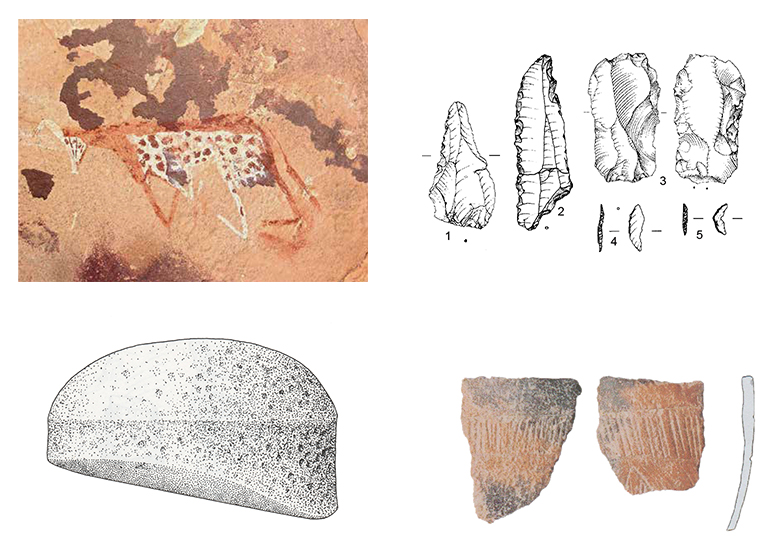
Colour pigments used in rock art (red, white and yellow) were available from all around the main Abu Ras rock art sites in the pediment area on the west side of the Abu Ras plateau (Kuper, Leisen et al 2010, p.9-11). No pigment analysis has been carried out published on Gilf C rock art but extensive analysis has been carried out on the Gilf B rock art at Wadi Sura II and this can be applied to the Gilf C sites. All pigments were locally available (figure 7), and include red ochres (hematite), yellow ochre (limonite) and goethite (brown and white). They are exclusively inorganic and therefore not sensitive to light, which accounts for their extraordinary depth of colour. There are no signs of binders but sandstone is porous and they may not have been needed. Pigments may have been ground on the grinding equipment that is usually thought to be used for grass preparation, and they were apparently mixed on sherds of pottery (Krause et al 2013, p.59-61).
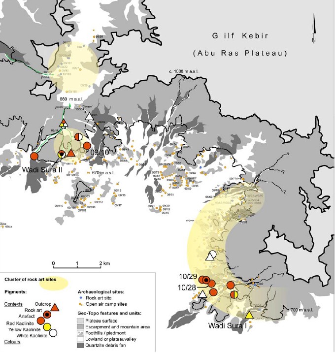 Figure 7 – Map showing the positions from where colour pigments were
collected in outcrops and archaeological sites, as well as the general
distribution of rock art sites. (Source: Kuper, Leisen et al 2010, p.10, figure 10)
Seasonality
Seasonality is considerable for all wild plant and animal species in the dry savannah environments discussed and is influenced by rare but valuable rainfall events in the wadis and deserts. Rainfall varies both geographically and temporally. A useful analogue for conditions in the plains surrounding the Gilf Kebir during the early Holocene may be provided by the Sahel today, where monsoonal rains late in the year provide a richly green environment, but the dry season may result in conditions that resemble today’s arid zones. Figure 8 shows dry and wet season conditions in the Senegal, which provides an impression of the environmental extremes that may have been experienced.
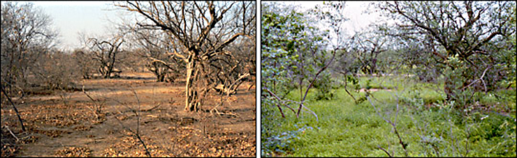 Figure 8 – The same place in dry and wet season conditions in Senegal,
where conditions were probably comparative to those around the Gilf Kebir
in the mid-Holocene. (Source: NASA https://bit.ly/2kr5Hb4)
3.1.2 Physical Assets
Settlement location, character and size
Although the Gilf B is well represented in the northwest of the northern plateau, the Gilf C is represented by much fewer sites and less dense concentration of settlement sites. Schön designates Gilf C as the main occupation phase of Wadi el-Akhdar (Schön 1996), where the earliest Gilf C sites were found. In the Wadi el-Bakht they last later than Wadi el-Akhdar sites, probably due to the earlier breach of the retaining dune in Wadi el-Akhdar, meaning that Wadi el-Bakht became the primary location for occupation towards the end of Gilf C (Linstädter 2005g, p.364). The destruction of the Wadi el-Bakht dune barrier marks the end of the occupation of the Gilf C. Sites on the blocking due include 82/10, 82/11 and 82/14, those on the playa itself include 82/15, 82/22/ 82/24 and 82/17, and those on the plateau at 99/51 and 00/73 with smaller inventories at 99/50, 99/53 and 00/74 (Linstädter 2005g, p.355-358). Hearths were found at many of the sites (Schön 1996, p.125-128).
Settlement sites are distributed mainly in the southeastern wadis of the Gilf Kebir and on the plateau within reach of these wadis, up to a distance of 20km2 (Linstädter and Kröpelin 2004; Kuper et al 2009a). Unlike the occasionally vast sites of the Gilf B, which sometimes reached up to 10,000m2, the largest of the Gilf C sites reached only 80-100m2 and these were characterized by a low artefact density, with 7-15 artefacts per square metre (Linstädter 2003a, p.136). Most were very ephemeral. There were more sites on the plateau than there were in the wadis, marking both a change of land usage strategy and a change in the land available for subsistence activities. There have been no findings in Wadi Maftuh, for example, which contained a dune lake playa in this period, but there are plenty of sites on the nearby plateau (Linstädter and Kröpelin 2004). At the same time, there were both smaller satellite sites, which seem to represent temporary camps for herding and stone collection, and larger base sites that seem to have provided focal points for visits, and where the primary occupation would have been located (Linstädter 2003a). Linstädter describes a high degree of localized mobility between plateau base camps, plateau campsites, plateau workshops and wadi-based base camps. Some of the plateau camps, which were found over a 20sq km area, were well-developed with pottery and grinding stones (Linstädter 2003a, p.135). This suggests a) quite a complex network of interaction between different site types in the Gilf C, and b) that the Gilf area was used as more than a refuge at this time, offering greater potential for more widespread exploitation than in previous periods, in spite of the lower rainfall levels in most of the eastern Sahara in the mid-Holocene (figure 9) (Linstädter 2003a).
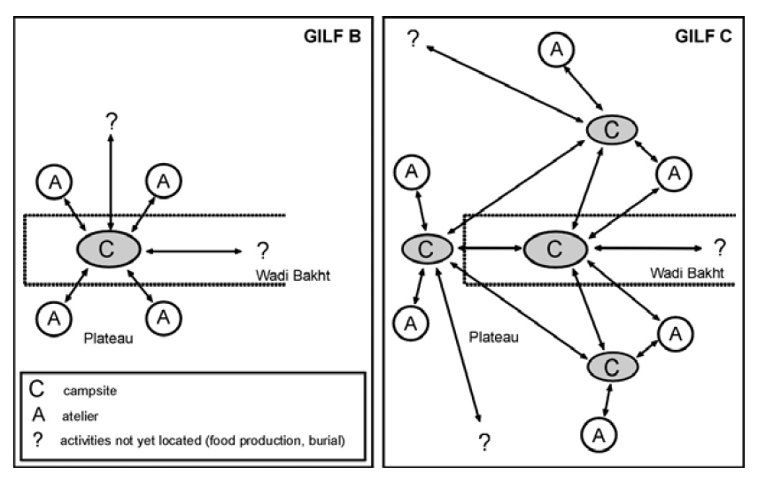 Figure 9 – Diagram of site usage, comparing Gilf B and Gilf C, showing
how in Gilf C base camps remained in the wadi, but a more complex arrangement of
camps and ateliers extended on the plateau (LInstädter and Kröpelin 2004, p.773, figure 12)
Site 81/4 in Wadi el-Akhdar is a typical surface scatter, a large concentration of stone artefacts, c.10m x 15m containing the remains of a large hearth (figure 10) (Schön 1996a, p.217-220). As with many Gilf C occupation remains, there are few microliths and the assemblage is dominated by larger pieces, some over 10cm long, with fairly regular retouch along the edges. There are also high numbers of denticulates and an unusually high number of borers with some scrapers (Schön 1996a). The preferred material of choice was quartzite, making up between 98% of the assemblage. Other materials in much smaller volumes were sandstone, siltstone, chalcedony, quartz, basalt and Libyan Desert Glass (Schön 1996a).
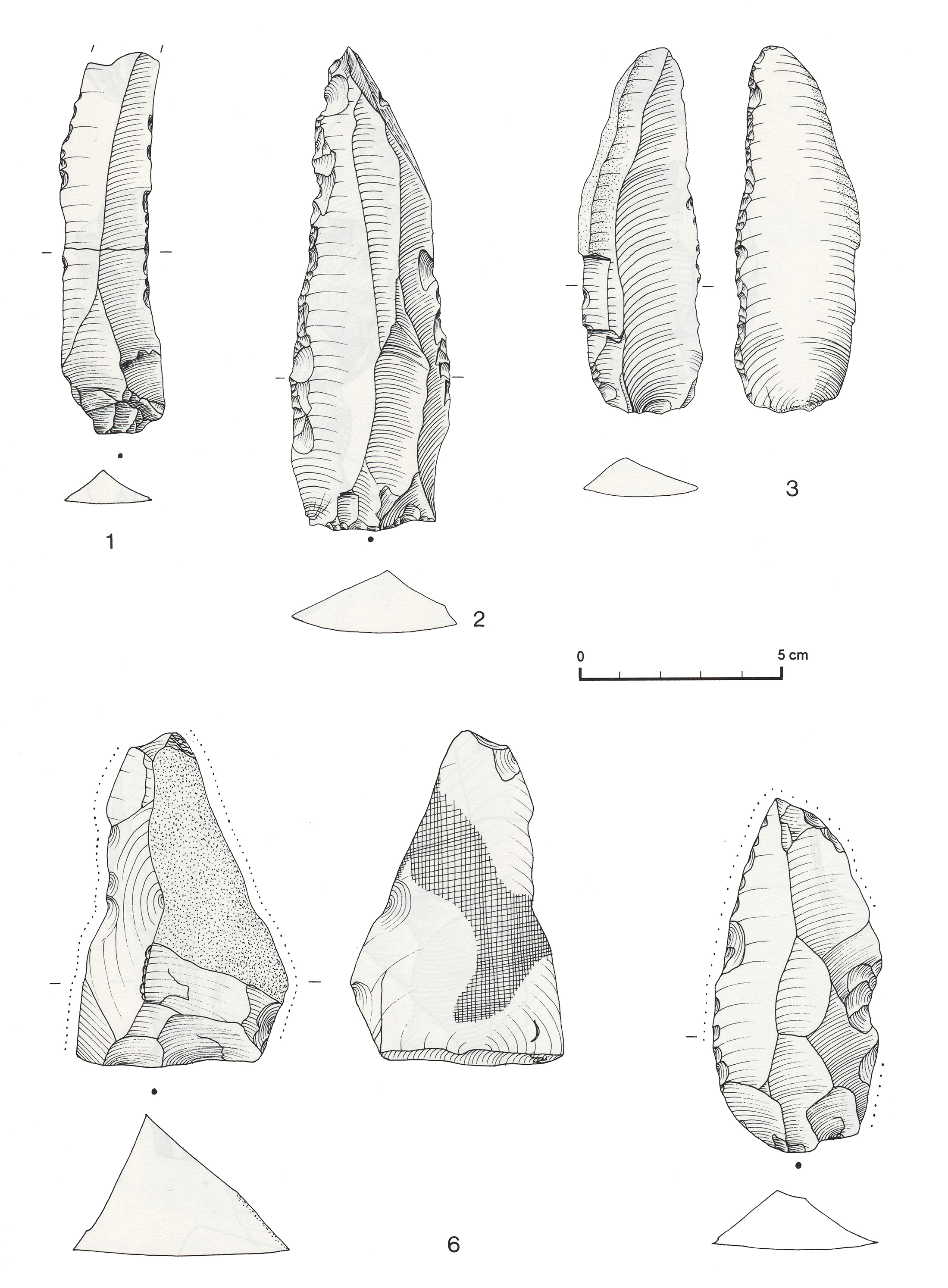 Figure 10 – Lithics from Wadi el-Akhdar 81/4. 1, blade with use retouch;
2 and 3, retouched blades; 6 and 7, pieces with polish marked by dotted line.
(Source: Schön 1996, p.582, plate 78)
Site 82/15 (Von Cziernewicz 2005) is a Gilf C site located on the wadi playa (figure 12). The site consists of a mixture of surface finds and objects found during excavations. Seven areas were excavated across the site, and all produced charcoal, although no hearths or other structures were identified. 310 sherds were found of which 195 (63%) are undecorated and the rest (115 sherds) were decorated, using a verity of decorative motifs and techniques, mainly comb-impressed and rocker-stamped. A wide range of physical forms were represented. Lithics were on quartzite (880 pieces) (figure 11), chalcedony (50 piece) and only three were on quartz and quartzitic porphyry (Von Cziernewicz 2005, p.226-7). Five different types of core are represented: single platform, three or more platform, discoidal, wedge-shaped and undefined. Refitting analysis suggests that cores were reduced on site. Tools were both retouched and non-retouched. Although no separate workshop areas were identified, different parts of the site appear to have been used for different activities, particularly tool manufacture and plant grinding (Cziernewicz 2005, p.228). Ostrich egg and shale beads (totalling 141 pieces) were evenly distributed across the site, including preforms and finished items, all between 8-12mm diameter and 2-4mm thick. The only bone fragments were apparently gazelle. The site probably represents a temporary occupation.
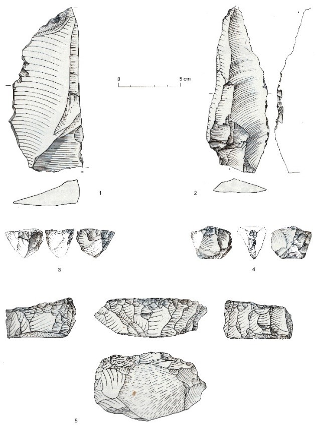 Figure 11 – Lithics on quartzite from Site 82/15, 1 and 2 are artefacts,
3, 4 and 5 are cores (Source: von Czerniewicz 2005, p.229, figure 14)
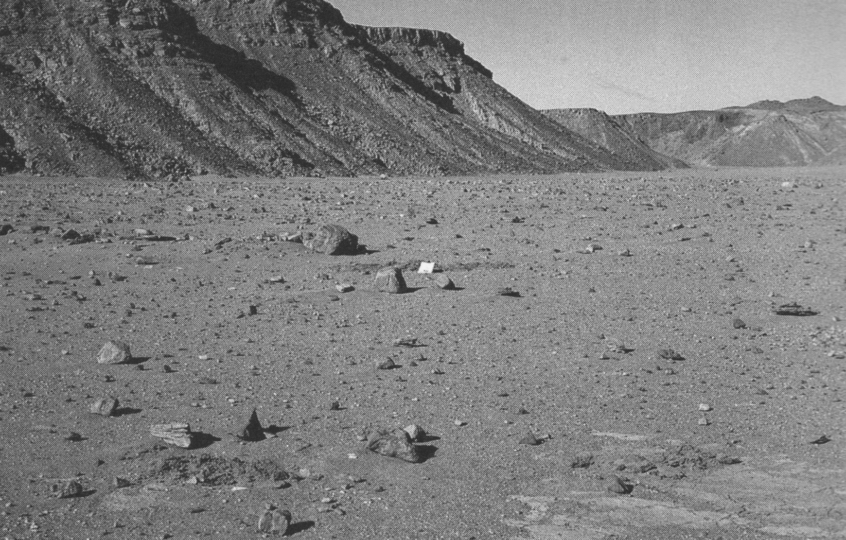 Figure 12 – Wadi Bakht 82/12 (Source: von Czerniewicz 2005, p.214, fig.1)
Site 82/24 (figure 13) (von Czernewicz 2005) in Wadi el-Bakht was similar to 82/15 but lacks ostrich eggshell beads, and the core reduction strategy was different including cores with opposing platforms, two platforms, 90° angle reduction and with three or more platforms are represented. Only two burned pieces of wood were found, both of gazelle (von Czernewicz 2005, p.249). Quantitative mapping demonstrated that both artefacts and raw materials were highly scattered. A possible hearth was red-stained and contained charcoal.
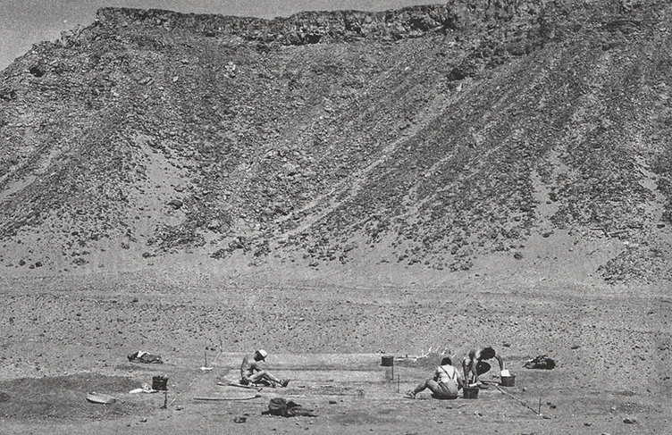 Figure 13 – Wadi el-Bakht site 82/24
(Source: Von Cziernewicz 2005, p.235, figure 19)
Site 82/22 in Wadi el-Bakht is a late Neolithic (Gilf C) surface collection near the dune playa is next to a pit containing some charcoal fragments (Fäder 2005). Artefacts are scattered widely and may represent of the remains of a destroyed site or be the remains of a site that was situated higher than the scatter’s current location. It is represented mainly by decorated and undecorated pottery and some large stone tools, including flakes and blades. The pit found in association with the finds was deemed to be too wide to have been of natural origin and too deep to have been dug out by animals in search of groundwater (Fäder 2005 p.203) and may therefore have been a man-made waterhole, comparing well with slightly larger examples found at Bir Kiseiba to the east, as described by Kobusiewicz (2003, p.96, fig2). Poorly preserved cattle teeth were found, but their dating is uncertain and may have belonged to modern groups who used the Gilf and Uweinat areas (Almasy 1929; Gautier 1980, p.342).
Site 99/53 is based on a quartzitic outcrop on the plateau 3.5km west of the blocking dune (figure 14), and was the subject of three days of fieldwork between 1999 and 2000, revealing Gilf B and C assemblages (Claßen and Pastoors 2005). Quartzite was the most commonly used raw material in the Gilf, and the combination of water availability and a raw material resource accounts for the repeated use of the site and the 65 workshops discovered. The quartzitic outcrop was 300x200m in area and there were three small playa basins, respectively 2400m2, 4800m2 and 800m2, the shorelines of which were dotted with workshops (Claßen and Pastoors 2005, p.260). The main activities at the site were the acquisition of raw materials and the production of blanks. Sites are generally very small and the workshop remains suggest that only one person at a time may have been involved in creating the output (Claßen and Pastoors 2005, p.268). It is possible that this is an indication of individual or family decision making in action, with individual family members going to the plateau to manufacture tools as and when they were needed. Individual decision making within groups is entirely usual in pastoral societies where individual households are frequently not bound by the decisions of the larger group and may act independently (e.g. Bekure and Grandin 1991).
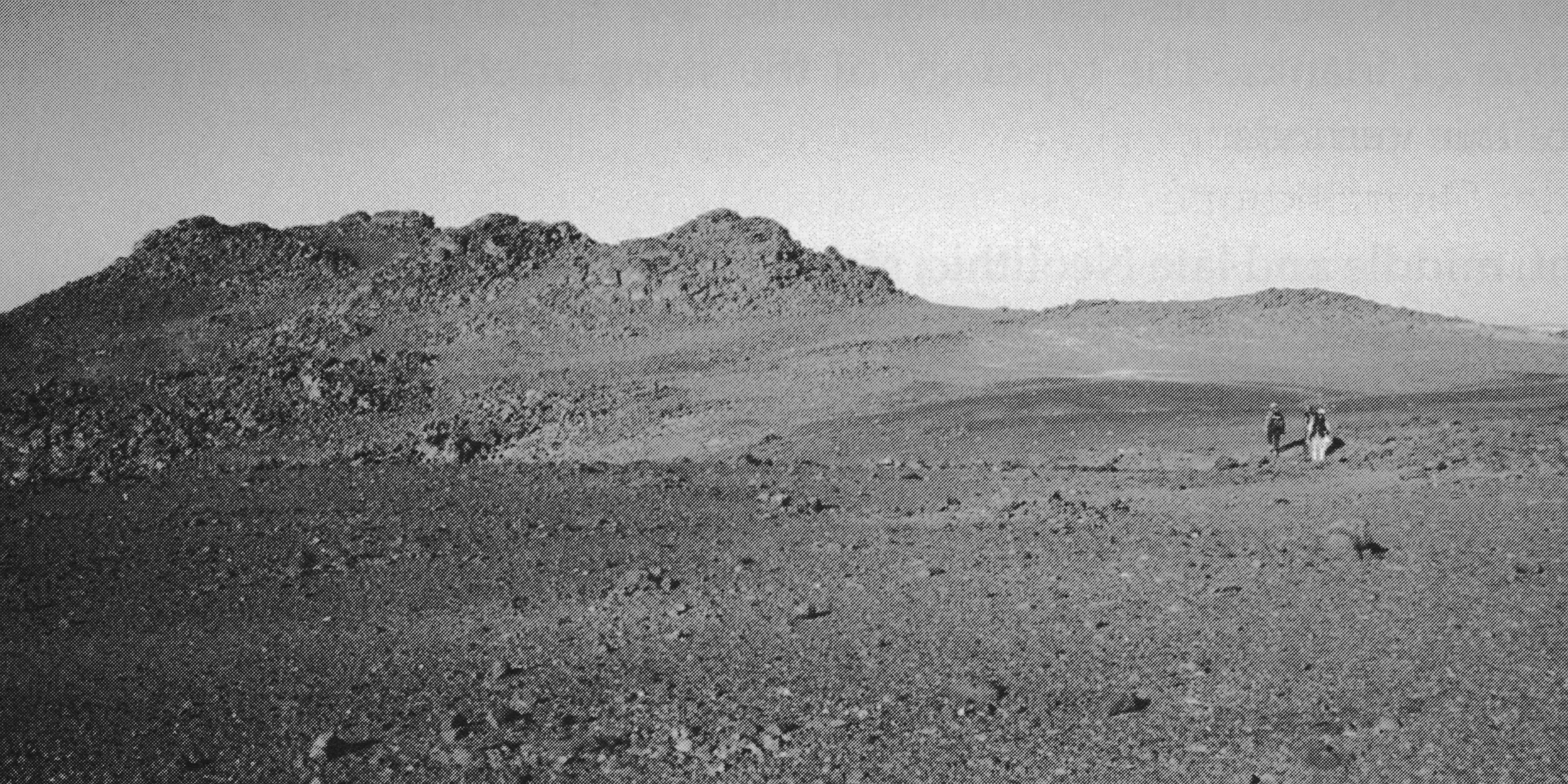 Figure 14 – Wadi Bakht 99/53 view from the southwest towards the
quartzitic outcrop (Source: Claßen and Pastoors 2005, p.258, fig.2)
Like Nabta, the Gilf Kebir is a perfect example of what Schlanger (1992) refers to as a “persistent place,” a concept that has been used in many studies since that date and encapsulates the idea that certain localities were used repeatedly over the long term, due to their suitability of their particular characteristics for certain activities, natural features that attract repeated occupation and the accumulation of material remains at those localities (Schlanger 1992, p.91). In the case of the Gilf Kebir, the main attraction of the area was the combination of dune playas, small playa pools activated by rainfall and the combination of savannah and plateau resources. Linstädter describes the network of sites as an entire landscape of different usage types and co-ordinated activities (2003b) indicating that neither settlement nor resource exploitation were simple.
Raw material acquisition
Gilf C tools were made on a variety of stones, including quartzite, sandstone, siltstone, chalcedony, quartz, basalt and Libyan Desert Glass (Schön 1996), Quartzite was by far the most dominant material selected, representing up to 90% of the toolkits, and was available on the plateau. A number of tool-making campsites on the plateau near quartzite outcrops have been identified (Linstädter 2003). Raw material exploitation on the outcrop was extensive, with a set of camps and workshops extending beyond the wadi edges up to a 20km area.
In the pediment areas there are sources of red and yellow ochre (haematitic and liminitic earth) and white clay, some of which were used to create the rock art at a number of sites in the northwestern Gilf Kebir (Kuper, Liesen et al 2010, p.15). This would have been easy enough to acquire, within easy reach of the shelters where the rock art was painted.
Clays were formed by the playa sediments but there is no indication of pottery manufacture at any Gilf C site, apart from a possible hearth-kiln at 81/19 (Linstädter 2005f; Wagner 2005, p.303).
Ground stone tools were not made from local fabrics, and there are no local resources for flaked stone tools made of chalcedony and other non-local materials.
Wood for tool manufacture or burning was available locally, although its quantities were probably limited and may have been restricted by social proscription.
Food acquisition and production technologies
Lithic tool technologies
The main material to survive in the form of implements is stone. The flaked tools consist mainly of non-standardized tools, most of them much larger than those in the Gilf B, much less specialized and labour-intensive (figures 11, 10-6 and 15-3). They include both retouched and unmodified flakes and blades and include scrapers, drills and cores. Microliths are rare but comparable to those from the Gilf B. The tools were less diverse in form and the lower emphasis on microlithic tools suggests that hunting was less important.
The Gilf C toolkit comprises a rough flake industry with very few diagnostic traits. The inventory consists generally of large pieces with little elaborate technology (Linstädter 2005g, p.366). Some flakes are edge-modified with retouch (figures 10-1,2,3 and 15-1,2) but there are unmodified blanks as well, and there are also drills and scrapers. Only a small number of microlithic components survive from the Gilf B toolkit (figure 12), made on small conical cores, but are rare (Schön 1996a; Linstädter 2005g, p.366). Schön describes the Wadi el-Akhdar inventory as displaying “an increasingly crude flaking technique” with a tendency towards large tool production, with blades dominating over flakes by the end of Gilf C (Schön 1996a, p.127) and on the basis of 14 assemblages, summarizes it as being characterized by continuous edge retouch, denticulated tools, crude flaking technique and an increasing emphasis on the use of large blades and non-standardized tools. No unnecessary time was taken to modify blanks, and the approach to tool manufacture was one of expedience. There are no features that indicate any attempt to achieve stylistic differentiation from tools produced by other groups.
McHugh found that cores and unmodified blades dominated Wadi el-Bakht assemblages and that these indicate that in situ production of tools at settlement sites.
A single bifacial tanged arrowhead is strikingly similar to one at Jebel Uweinat (Linstädter 2005, p.370), both of which may suggest connections to the oases, where a bifacial technology was a defining characteristic. The nearest of the oases, which could be reached by skirting the southern end of the Great Sand Sea, was Dakhleh, some 410km to the northeast.
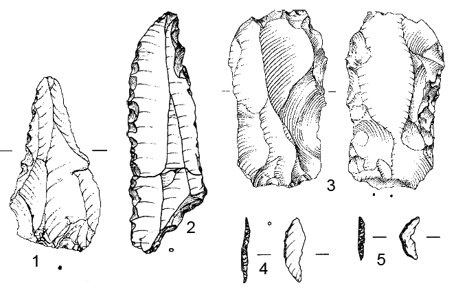 Figure 15 – Gilf C lithics. 1, 2 and 3 Retouched pices. 13 and 14 lunates.
(Source: Gehlen et al 2002, p.106, figure 17)
Groundstone equipment
The ground stone tools consist of mortars and hammer stones and upper and lower grindstones which were probably used primarily for grinding wild grain found in the plains around the Gilf Kebir. Fäder believes that those with almost polished surfaces may have been used for other purposes entirely (Fäder 2005, p.199). It is possible that these may have been used to grind ochre for rock art paintings on occasion. Some of the hand-stones, a form known over a wider area from the Sudan via Laqiya to Abu Ballas in the mid-Western Desert, known as the “Gilf type” (figures 16 and 17) are found frequently in both Wadi el-Akhdar and Wadi el-Bakht (Kuper 2007d). They are highly distinctive, mushroom-shaped implements, found in conjunction with ordinary flat grinders. It is possible that they were used to grind cosmetics or medical substances (Gehlen et al 2002).
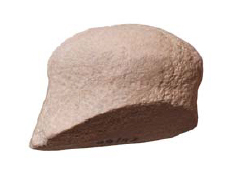 Figure 16 – Gilf type handstone. Examples are found in
Wadi el-Bakht, Wadi el-Akhdar and Wadi Sura (Source: Kuper,
Leisen et al 2010, p.22, figure 24)
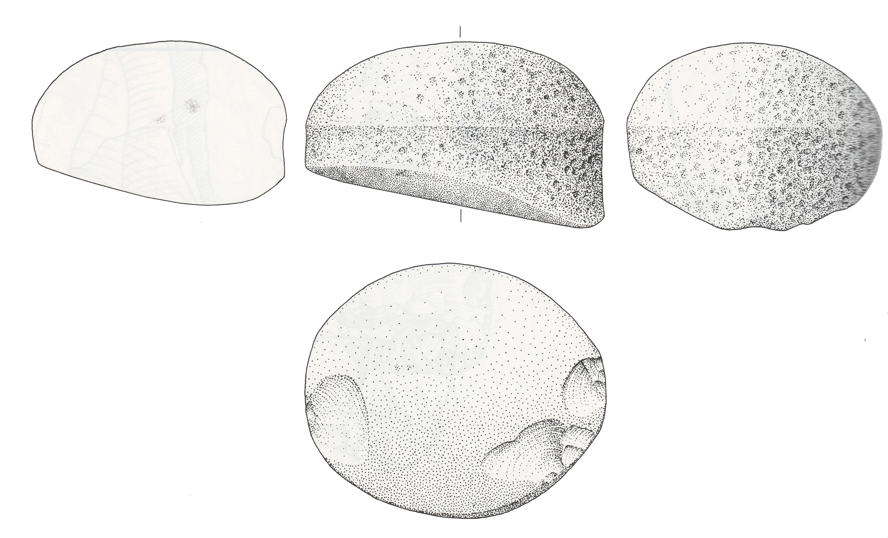 Figure 17 – Gilf type grindstone from Wadi el-Akhdar 81/4
(Source: Schön 1996, p.616, plate 85)
Ceramic container technologies
The only remains of ceramic vessels are sherds of pottery, mainly badly weathered. There are no indications of manufacturing zones at the pottery at any of the sites, except for a possible pit kiln at 82/18 (Linstädter 2005f, p.302-3). It is probable that it was brought in from elsewhere. The pottery is well fired, thin walled and decorated with impressed) and incised markings, with frequent comb-impressions (figures 18, 19 and 20). The most common motif is a herringbone pattern (figure 18) with incised or comb impressed lines, but there are a wide spectrum of other engravings and impressions (e.g. figures 19 and 20) (Gehlen et al 2002; Fäder 2005; von Czerniewicz 2005, p.223-5; Wagner 2005). In many cases decoration was confined to a band below the rim. All over comb incisions, which are also known from Laqiya are also placed in the Gilf C (Fäder 2005, p.182; Wagner 2005). Although no complete examples survive, vessels were apparently made in numerous different forms of vase, beaker and bowl, with both round and pointed bases. In Wadi el-Akhdar the most frequent combined herringbone decoration with pointed bases (Schön 1996, p.128). Shapes include open-mouthed forms, some waisted, some with pronounced necks, and one form slightly carinated; there are no dishes (Linstädter 2003a; von Czerniewicz 2005, p.222, p.240; Wagner 2005). The fabric usually contains mineral temper, as opposed to the organic temper favoured in the Gilf B (Gehlen et al 2002). Surface treatments range from very simple surfaces without special care to examples that are so finely smoothed that the surface appears to have a slightly “speckigen” (greasy) shine (von Czerniewicz 2005, p.221).
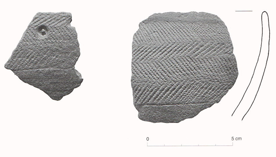 Figure 18 – Gilf C ceramics with herringbone decoration from site 99/50
(Source: Linstädter 2005e, p.274)
Many ceramics were treated on exterior and interior surfaces, with the exception of some that only have smoothed interiors, possibly to improve impermeability. The colouration of the vessels indicates firing in a reducing atmosphere (von Czerniewicz 2005, p.222). A single piece of calciform beaker was found at 81/25 but is not thought to have been produced locally. A good collection comes from WB82/17 where 521 sherds represent some 287 vessels, representing “one of the most extensive prehistoric pottery collections from the Western Desert” (Wagner 2005, p.305). Analysis by Wagner determined that there were many forms of decoration dominated by herringbone motifs, often confined to a band beneath the rim (Wagner 2005, p.326-335). The majority appear to have been round-based but two sherds indicated that pointed vessels were also present. Both open-mouthed and constricted forms were identified, and both straight and slightly everted rims were common at both WB82/17 and other sites, with straight forms dominating (Wagner 2005, p.319-321).
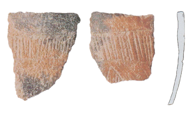 Figure 19 – Gilf C pottery from Wadi Sura site 09/15
(Source: Kuper, Reisen et al 2009, p18)
The sherds are all highly weathered so no data remains regarding the use of pots. It is known that the value of cooking pots was considerable for improving the digestibility of foods, reducing toxicity, and postponing spoilage (Grillo 2014, p.117), and ethnographic research by Grillo (2014) has shown that pottery and nomadic lifestyles are compatible. Amongst others, Bassi (1997) and Grillo (2014) emphasise that groups who use but do not manufacture pottery may have a trading relationship with groups who do manufacture pottery, leaving the question open regarding whether Gilf C pottery was made by the Gilf C occupants, was manufactured elsewhere by the same communities, or was purchased from craft specialists from other ethnic groups and brought and used here and elsewhere. The latter seems the least likely due to the dominance of the distinctive herringbone pattern, which may argue for investment in efforts to establish group identity and social differentiation.
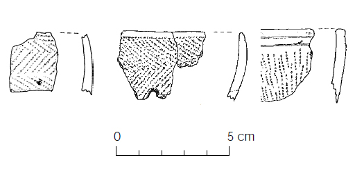 Figure 20 – Gilf C pottery sherds (Source: Gehlen et al 2002, p.106, figure 17)
Craft skills
Perishable goods must have been present in the domestic and economic inventory (Hurcombe 2014) but have not survived in the archaeological record at the Gilf Kebir, although some of the raw materials that might have been used are listed in table 6. Juncus, for example, its name deriving from the Latin “jungo” (to bind or tie) could have been used for cordage, matting and others crafts, as it often is today (Boulos and el Hadidi 1984, p.110; Mahmoud 2010, p.86). Balanites aegyptiaca has multiple uses today, including the manufacture of tools and spoons due to the fact that although it is hard and durable it is easy to work (Mahmoud 2010, p.45). Maerua, which is a very light wood, is similarly popular for tool manufacture (Mahmoud 2010, p.96). Phragmites is frequently used for the construction of baskets, thatching, mats and arrow shafts (van Oudsthoorn 2010, p.113) and the bark fibre of Acacia ehrenbergiana is often used for rope-making (Mahmoud 2010, p.27).
Beads made of stone and ostrich eggshell are represented, and include preforms and finished items, all between 8-12mm diameter and 2-4mm thick.
Shelter
Although many of the sites consist mainly of occupation scatters, there are stone structures too that give some indication of both temporary and more permanent structures (Linstädter 2002). On the plateau near the southeastern Wadi Muftah a site within a shallow depression featuring drainage lines, with sufficient artefacts to indicate a short to medium term stay, has large blocks brought from surrounding outcrops and notched to form some sort of construction, interpreted as the base of a tent (Linstädter and Kröpelin 2004, p.772). Rather more sophisticated sites also appear on the plateau. Linstädter (2003a) describes, very briefly, stone constructions including complex dwellings consisting of several units, simple wind shelters and circular constructions. This implies a mixture of mobility and nodes to which people returned.
Economic structures
There are very few requirements for structures to support pastoral activities. For the Jebel Uweinat it has been proposed (Peroschi and Cambieri 2011) that low stone rows may have been hunting kites, which have been discussed elsewhere in the Western Desert by Riemer of the sort described by Riemer in the Western Desert (Riemer 2004a) but there is no further data and nothing similar has so far been identified in the immediate area of the Gilf Kebir.
Cemetery / Religious architecture
There are no dated structures associated with religious or ceremonial activity.
Food storage systems
Apart from the presence of pottery, there is no indication of storage at any of the sites.
Transport
Many objects, as well as preserved food, can be carried by people. However, there are elements that Binford refers to as “site furniture” (1976, p.242), components that may have been too heavy to move over long distances, including grinding stones and large ceramics, and may have been left at sites that were revisited many times. Heavy items that would have been difficult for humans to carry. Hayden (1989 p.8) estimates that a family unit would be able to carry no more than 1-2 kg, but heavy items may have been carried by domesticated animals. Close points out there is no reason why herded animals could not have been used as beasts of burden for carrying heavier items (Close 1996, p.550), in much the same way as people later used donkeys and camels. The most obvious requirement for transportation other than water, which could have been carried in hides, and grinding stones, was pottery. As Grillo demonstrates (Grillo 2014), a mobile lifestyle and pottery are entirely compatible. One Gilf rock art site, 09/101, shows a painted cow with a bag hanging down its side (figure 21), a possible indication that cattle were used as pack animals (Kuper et al 2009a, p.19). In theory, goats could also have been employed to carry lighter loads. There are ethnographic examples that confirm that livestock could be used to carry objects. For example, S.E. Smith says that in the Sahara cattle were used for transport when she was carrying out her analysis of Malian pastoral practices (S.E. Smith 1980, p.486) and Stenning shows a photograph of a Fulani woman with a cow loaded with items prior to moving camp in the dry season “Stenning 1959, p. ii, plate 1).
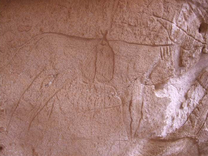 Figure 21 – Cattle-Herder style rock art at Wadi Sura site 09/101 showing
an animal with a bag hanging from its back (Source: Kuper et al 2009a, p.19, figure 20)
Fuel
In all societies fuel is a fundamental requirement, used for staying warm, cooking, drying grains and warding off wild animals. It could also be used for manufacturing pottery and heat-treating stone tools. Given the available wild fauna, and assuming that domesticated herds were the main form of dung provision, dung should have been readily available, particularly concentrated beneath trees that would have provided shelter. Linseele et al (2010) attest to the sheer amount of fuel that can be assembled from herd animals, Evans-Pritchard gives the example of dung being used as fuel by the Nuer (Evans-Pritchard 1940, p.258) and Portillo et al (2016) describe how in their ethnographic research in northwest Tunisia ovicaprine dung was the main source of fuel for domestic purposes.
Burning wood, which was a relatively scarce resource, and one which was not readily renewable, would have been a much higher-risk option for the long term security of the environment, as recognized by Eastern Desert Bedouin today, who have strictly enforced social and religious mechanisms for protecting living trees (Bollig 2006, p.336-7; Harir 1996; Hobbs 1989, p.53; Hobbs et al 2014; Krzywinski 1996; Simpson 1992; Wendrich 2007, p.74). Linstädter has suggested that Wadi el-Akhdar and Wadi el-Bakht were used alternately to save wood, allowing trees to recover (Linstädter 2002; 2007, p.23). All types of wood could have been used but Acacia is a favourable choice as it has a relatively low moisture content of 29%, burns very slowly, providing heat over long periods (Belal et al 2009, p.70-71; Springuel 2006, p.4, p.69-70). Tamarix also provides good firewood (Neumann 1989, p.120), and Ziziphus, known today for its value as fuel and high quality charcoal (Arndt et al 2001), was found in the form charcoal in some hearths such as 82/19 (Linstädter 2005f, p.302-3), as well as the possible pottery kiln at 82/18 with its four-piece roofing feature (Linstädter 2005f, p.302-303). Balanites aegyptiaca is a hard wood also often used a fuel today (Mahmoud 2010, p.45).
Craft infrastructure
Apart from a possible simple pottery pit kiln at 82/18, no kilns or equipment associated with pottery manufacture were found. 82/18 consists of a heat-sealed hearth-like entity c.1.50m in diameter that had escaped deflation but was still not in a good state of preservation (Linstädter 2005f, p.302). It was provided with a four-piece wooden roofing feature, which is not associated with any of the Gilf hearths, and requires an explanation for which a pottery firing environment is plausible (Linstädter 2005f, p.302-3). No comparable structures have been located to date.
No evidence of the perishable basketry, cordage, matting and textiles that must have been in use (Hurcombe 2014) have been found at Gilf C sites.
3.1.3 Social Assets
Status, roles and social organization
There are no artefacts that could be interpreted as status items. However, it can be proposed that the multiple livelihood threads adopted during Gilf C, based on herding, hunting, plant gathering and raw material acquisition and associated scheduling requirements would have required organization for both community and herd welfare. It is probable that this required a considerable level of organization, favouring some form of internal organization where multiple households could contribute to the decision making process, with a great deal of co-operation between households for scheduling activities (Müller et al 2007; Schareika 2014; Spencer 1998, p.249). The possible combined use of the Gilf as rainy season pasture with the Jebel Uweinat as a dry season resource, probably involved decisions about who to leave at Uweinat and who to take to the Gilf, and these would depend on the skills that were required for the weeks when the dune lakes in the Wadi el-Akhdar and Wadi el-Bakht were viable.
The herds themselves may have had a certain amount of status value for individual families or for the group as a whole, depending on how groups and households were organized. This is often the case today, where large numbers of livestock may be maintained for status rather than, or as well as, for purely economic reasons (Evans-Pritchard 1940, Chapter 1; Klima 1970, p.4; Lienhardt 1961, p.10-27). Jesse et al (2013, p.90) suggest that cattle portrayals in rock art may be an indication of “meta-symbolic capital” reflecting not merely the economic value of cattle but its role in conferring status and wealth upon individuals, households and communities, ideas explored by Dittrich 2017; Honeychurch and Makarewicz 2016, p.350-351; Oma 2010; Orton 2010; Sykes 2014.
Religion, ideology and spiritualism
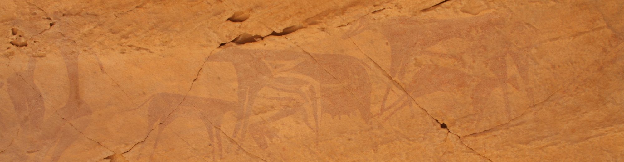
There is less evidence for belief systems beyond the purely practical business of everyday life during Gilf C than in Gilf B. The headless creatures and floating or swimming figures of Gilf B are no longer depicted in rock art, and displays of dancing and other communal activities are absent. Instead, the rock art depicts cattle either painted or engraved. Animal hides are sometimes painted in different colours, picking out particular markings and features (figures 22, 23 and 24), identifying specific individuals in the herds (Evans-Pritchard 1940, p.42-3 fig.6, 37, 41). Other livestock are sometimes represented and human figures with hunting paraphernalia also appear. The relationship between hunters and animals in the Gilf B would have been completely different from that of the livestock herders of Gilf C, when relationships between humans and their livestock would have developed along much more intimate lines, with individuals identifying closely with livestock (Marshall and Weissbrod 2011, p.402). In modern ethnographic examples, herders know the names, markings, key features and characteristics not only of their own animals, particularly cattle, but often of their neighbours’ too (Jesse 2007, p.46; Lambrecht 1976, p.29) and they are often central to rites of passage and group spiritualism (Evans-Pritchard 1940; Lambrecht 1976; Leinhardt 1961). They are often status symbols as well, and are of course considerable capital assets in terms of bride-wealth (Evans-Pritchard 1940, p. 17) and possibly for exchange negotiations (e.g. Vivelo 1977, p.98). Smaller sheep and goat are also occasionally depicted in the rock art, although so rarely that their status in these contexts is obviously secondary. In the cattle depictions of the Gilf Kebir, and more dramatically in the Jebel Uweinat, important characteristics are physical appearance, including patterning and colours of the hide, prominence of the horns and calves (figures 22, 23 and 24) (Zboray 2009, 2013; Kuper et al 2009a).
 Figure 22 – Detailed markings shown on a bovid in AM51 in Wadi Abd el-Malek
(Source: Zboray 2010, p. 242, figure 2)
Zboray divides the Gilf Kebir into five zones, each producing between two and over forty rock art sites and clusters of sites. The latter, with over forty sites, is around Wadi Abd el Malik and Wadi Sura and includes the well-known Cave of Beasts and Cave of Swimmers. In the southern Gilf Kebir, where the main concentration of Gilf C habitation is concentrated, there are only four known rock art sites (Zboray 2009). Gilf C subject matter focuses on livestock, mainly cattle, but also includes hunters with bows and arrows (Zboray 2009). Rock art is confined to specific locations, caves and rock shelters, some of them highly secluded, almost exclusively on the western side of the Gilf Kebir, on the opposite side of the Gilf from the main sites of occupation. These are apparently special environments. The subject matter during Gilf C always features cattle, indicating the high ideological value that was placed on this type of livestock, favouring them over other representations of ovicaprids, wild species, and humans with narrow bodies and large legs, and is typical of the Cattle Herder style (Zboray 2013). In Jebel Uweinat 337 of 414 rock art sites are in the Cattle Herder style, with cattle the dominant theme, although some also show goats and humans are depicted with various notable features including body decoration, waist pouches, loin cloths, shoulder bags, footwear and bows and arrows (Zboray 2010, 223-4) (e.g. figure 23). The succeeding Uweinat Cattle Pastoralist style is also found at Gilf Kebir, but only at two sites: SE1 and WG53 (Zboray 2013). Woods (2016) ascribes Gilf B rock art at Wadi Sura I and II to shamanism and rainmaking rituals but she does not consider the Gilf C or contemporary Uweinat panels and there is no current evidence to support either for Gilf C rock art, although her comment that “shamanic art tends to be characterized by a small number of species functioning as guardians or vehicles for spiritual encounters” (Woods 2016, p.140) might be a starting point for such an investigation.
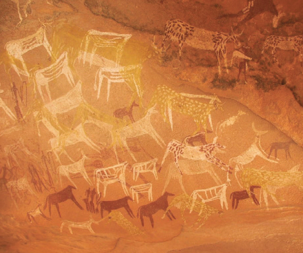 Figure 23 – Cattle-Herder style rock art at WG35 near Wadi Sura
(Source: Zboray 203, p.19, figure 4)
Gosden describes how “each culture creates its own sensory environment, both physically through constructing a material world with its own set of sensory principles and culturally through emphasizing and valuing certain types of sense impressions over others” (2001, p.166). Darnell (2009, p.85) suggests that rock art has a role “creating meaningful space in the desert vastness” thereby “socializing the topography.” Bradley (1997) and Riemer and Förster (2013, p.42) see rock art as marking landscape and roadways as indicators of territory and affiliation. All four incorporate the idea that sensory output like rock art may help to define, personalize and establish rights over certain areas. Given the high levels of mobility proposed for the Gilf residents (Riemer 2009; Lenssen-Erz and Linstädter 2010) it is entirely likely that rock art and other markers were used to create a sense of identity within a cyclical space that could involve many 100s or 1000s of kilometers. I would suggest that as well as being points in space, they could be seen rather as points in cyclical time, as discussed by Olupona (2014, p.6), who points out that many indigenous African religions have a combination of linear and cyclical time and Bell and Walker (2005, p.11) who discuss dimensions of a much larger landscape of both movement and perception.
Wengrow’s discussion of cattle cults includes the suggestion that animal interments indicate the increasing importance of the non-human world in mid-Holocene contexts along the Nile valley (Wengrow 2001, p.98), and this idea might be extrapolated to rock art panels where domesticated animals dominate and may be incorporated into economic routines and social values, and at the same time may have been connected with the supernatural realm. The investment in placing rock art in particular features, mainly rock shelters and caves, brings the spirituality of the herd into areas of shelter or special significance. WG35, for example, was not concealed but it was very difficult to see, a painted rock shelter, its ceiling only 60-80cm off the ground (Honoré 2015). The detail on many of the animals depicted suggests an intimacy of knowledge and a respect for not merely the animals but the livelihood that they represent. Three main phases have been identified at WG35, depicting 80 humans, 71 bovines (some with spotted coats characteristic of Gilf rock art, some with oversized udders), and 4 caprines, 3 giraffes, and calves or dogs, amongst other images that cannot be identified. Some of the bovines in phase 2 appear to have been deliberately depicted without heads (Honoré 2015), leading to questions about their significance. Other sites were more open, but still carried the sense of there being a division between defined space and the outside world. Jesse et al (2013, p.95) suggest that sites where individual animals are distinguished from one another in markings and horns may express the opposition between communally herded livestock and the need for households to operate as “small scale entities.”
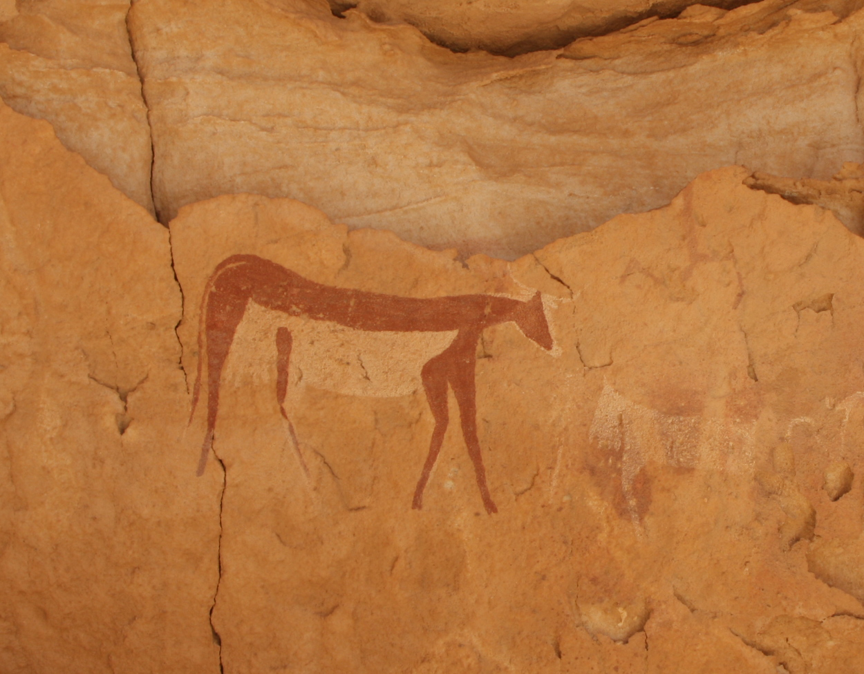 Figure 24 – Wadi Sura 1 (Soucre: Photograph by Andie Byrnes)
At Gilf Kebir, the division between residential areas (on the east of the southern Kemal el-Din plateau) and rock art zones (on the west of the northern Abu Ras plateau) may have been tied in with contemporary ideas about the relationship between the two zones, about their spiritual significance or their practical value. The existence of older Epipalaeolithic rock art in that area may have imbued the northwestern edges of the plateau with special significance, or perhaps these areas, often at the edges of seasonal and highly ephemeral pools, were used as additional water sources at certain times of year. The presence of shadowed rock shelters may have been another factor. Alternatively, it may be the more prosaic fact that ochre was readily available in that area.
Theoretical approaches and methodologies for the analysis of this rock art need to be employed. Renfrew, for example, (1994, p.6-8) emphasizes the need to link whatever form of cognition is being analyzed to categories of human behaviour in order to ascertain aspects of existence, emphasizing that design and planning are important aspects of cognitive behaviour and should be considered in any attempt to examine symbolic representation. In the same volume Bell (1994, p.20) suggests that explanations about the ideas behind such conceptualizations “should be ‘close’ to the data: they should be directly testable themselves or they should entail other statement(s) that are directly testable.” Polkowski has proposed an analytical and interpretative framework for the rock art of Dakhleh Oasis (Polkowski 2015a), which is a step in the right direction, but although surveys have produced substantial amounts of rock art (e.g. Zboray 2009) this sort of theoretical and methodological approach is yet to be applied in the Gilf/Uweinat areas. As von Czerniewicz et al (2004, p.95) and (Riemer 2009) point out, insufficient research has been carried out into the entire corpus of rock art in the Gilf and Uweinat area and I would suggest that this renders any ideas about interpretation no more than purely speculative at this stage. In both areas, what can be proposed with some confidence is that they are both places where occupation, whether residential or logistical, took place for periods of a few weeks or more and were returned to over many hundreds of years, and that people had a close personal relationship with those areas and sites.
There are few other indications of spiritual or religious behaviour in the Gilf Kebir. Bagnold (1931) identified a stone circle to the west of Gilf Kebir area in 1930. Twice the size of the Nabta Playa calendar circle (E-92-9) it was made of similar sized stones and is located at a small depression, which may have been a playa and may be of similar antiquity, but apart from one visit in modern times no further attempts have been made to assess it (Rosen et al 2008). Peroschi and Cambieri (2010) have identified monoliths, orthostats and tumuli in the Wadi Abd el Malik and, on the plateau above, standing stones. In the middle of the wadi are hut-like structures made of elongated stone slabs. The authors place it tentatively in Gilf C (Peroschi and Cambieri 2010), but there is no supporting data, and the wadi is at the far north of the Abu Ras plateau, where no Gilf C settlement sites have been found to date. Riemer (2012) has identified roughly made stone circles on a rock terrace about the Wadi Hamra and site 00/9 but the investigation was a single day of rescue work, and no further attempts to clarify whether these are ceremonial or, more probably, domestic. Until further investigation takes place these remain an interesting but unusable dataset.
Ritual and rites of passage
At the Gilf Kebir, the rock art is the only visible sign of religious activity, of material expression of belief or ideology. von Czerniewicz et al (2004, p.94) suggest that it is probable that “specialists made it at special occasions, i.e. it was part of ritual and/or religious activities, which by their nature are linked to the cosmology of people.” The original conceptualization of a place using rock art may be separate from activities that took place there later. von Czerniewicz et al, for example, suggest that a dominant feature of rock art locations is that they are often in front of open areas where ceremonies and dance could have taken place (2004). Appadurai (1996, p.179) discusses rituals of naming and initiation, which are often carried out in certain special places in order to reinforce identity and a sense of connection with a place, because “locality is an inherently fragile social achievement” that must be protected in any way possible. Wobst (2000, p.47) suggests that rock art provides a means of expressing social control under conditions of competition. This is echoed by Smith, who proposes that even where concepts of ownership are poorly developed “specific locations within the resource-catchment area that offer high resource abundance and predictability will be the subject of clear and strongly enforced control of access” (B.D. Smith, p.263). At the same time he acknowledges that land tenure arrangements may be highly complex and mutable (Smith 2011, p.263-4). This complexity may have been managed by both pragmatic negotiations and by affirmation of rights by reference to the spiritual world. Finally, Jesse et al (2013, p.93) see the incorporation of cattle into rituals as a means of allowing societies “to cope both physically and mentally with vulnerable conditions such as climate change.” Until these sites and their external spaces are excavated this is merely speculation, but is something clearly worth investigating.
Tradition, social values and social guidelines
Hunn defines traditions as “the products of generations of intelligent reflection tested in the rigorous laboratory of survival” (1993, p.13) and the remarkable homogeneity of conditions throughout the Gilf C period argues that whatever systems were in place throughout the Gilf C were indeed successful, allowing repeated return visits and supporting livelihood that was not challenged until climatic downturn at the end of the Holocene.
The ceramic component of Gilf C, part of a regionally broadly recognizable eastern Saharan body of plastic decoration, indicates affiliation with either values or concepts that were shared over an area that must have been larger than any one kinship network, as discussed above.
On a more localized level, the re-use of the northwest Abu Ras plateau for rock art requires some explanation, because the concentration of settlement is on the southeast Kemal el-Din plateau. There are two plausible explanations. The first is that temporary pools gathering along the base of the plateau following rainfall events were valued by herders who circled the Gilf until they reached this area around Wadi Sura. The second is that the existing rock art of the area, dating to Gif B, was considered to have value in its own right, part of a different tradition but still recognizably part of a long history of centuries of use, which might have been captured in oral history. In Wadi Sura I, Gilf B and Gilf C rock art sits side by side. In other cases, rock shelters are used for the first time, but are in the vicinity of the remarkable Wadi Sura II Gilf B rock art frieze.
Another sign of persistence of place (Shiner 1989) is the re-use of the same rock art sites and friezes throughout Gilf C. Sites like WG35 in the Wadi Sura area (figure 23) show complex scenes of cattle and herders superimposed over earlier scenes with similar themes.
Material expression
Materials cease to be inert as soon as people start interact with them, transforming them from raw materials into artefacts or structures via a relationship between vision, knowledge, ability and the materials used. Whether manufactured or acquired in exchange for other goods, they may represent a change in either kinship affiliation, cultural affiliation, economic changes including the adoption of delayed return strategies, dairying and concepts of ownership. In the Gilf C ceramics are much finer than in Gilf B, and a different decorative paradigm is adopted. Temper is mineral rather than organic, new surface treatments are applied and new decorative schemes are adopted. Lithics are also different from predecessors in Gilf B but I would suggest that this is less to do with symbolic or isochrestic communication than functional expediency. There are no signs of intentional stylistic rendering in any of the assemblages. There is not much evidence of Schlanger’s “mind in action” (Schlanger 1994, p.148).
Interestingly, after Gilf B ostrich eggshell beads were no longer made. One wonders if this was due to lost capital value, lost cultural value, a difference in self-perception and personal communication, or lost skills. Of all of these, lost skills seems to be the most improbable. Instead, the change of livelihood organization to include domesticated livestock may have been accompanied by new forms of self-identity, differentiation and expression. It is possible that ostrich eggshell is associated particularly with hunting, and that as hunting became less important during Gilf C the eggshell beads lost their significance.
Rock art is a transformative process, converting rock shelters from natural phenomena to places of special cultural significance, part of the landscape, but also subjected to human perception to become ideologically if not religiously significant. In both the Gilf Kebir and particularly in Jebel Uweinat this may have part of a system for managing multi-ethnic encounters of the sort described by Lightfoot and Martinez in border and frontier situations (Lightfoot and Martinez 1995; Lenssen-Erz 2012), where material culture may acquire special meaning, becoming “active symbols in broadcasting and even negotiating a person’s identity in culture contact situations” (Lightfoot and Martinez 1995, p.485). As Lightfoot and Martinez point out, traditions may remain very strong, resisting change, but it is also possible that new cultural constructs are invented as ideas, knowledge and innovations are exchanged. Rock art may have been used as part of a confrontation of identity and cultural transmission.
It is inevitable that the adoption of a livelihood based on domesticates had a major impact on group movements, decision making and sharing of both resources and products. As Miller says in his discussion of material items, or “stuff” in his parlance, in enhancing the ability to cope with environment via innovation or invention, unintended consequences in the form of by-products may be created (Miller 2010, p.53), which may include symbolic as well as practical issues that require tackling. The expansion of settlement patterns, the adoption or innovation of a new type of pottery, the development of lithic technology and the execution of rock art may all be material expressions of the need to adapt not to the climate or the environment but to the economic reality itself.
Mobility
Today the Gilf Kebir seems terribly remote, in one of the most inhospitable hyper-arid places on the planet but in the mid-Holocene it was the source of lakes filled with temporary water, within a few days of Jebel Uweinat with its high orographic rainfall, excellent wild animal resources, plant life, and permanent springs. It seems certain that the groups who painted cattle scenes in the Gilf Kebir in the Gilf C were the same people who painted similar scenes in the Jebel Uweinat in the Jebel Uweinat C phase, Zboray’s Cattle Herder phase (Zboray 2009). It was a few weeks away from Laqiya oasis to the south, and Kufra to the west. The Gilf is a magnificent natural structure, rising flat-topped above the plain like a vast wall, up to 300m high, visible for miles around. Used over centuries, it would have been perceived from one generation to the next as a familiar landscape, part of routine and everyday life; landscapes as dwellings, as envisaged by Ingold (1993, p.154) and Thomas (2008, p.305) and perhaps part of a supra-regional pattern of contacts of which herding was also a key component.
As has already been discussed for Nabta, ideas of mobility concern more than just physical movement. The occupants of the Gilf Kebir were probably moving between different types of savannah and highland range landscapes, each with their own hydrological system. The mental world view shared by the visitors to the Gilf would have been coloured by a shifting livelihood that included multiple topographies, each with unique characteristics. Whilst Sheller and Urry (2006, p.210) emphasize the immutability of the structures underlying mobility, Whittle (2003, p.43) emphasizes “separations, fragmentation and fission” and directs attention to the multiple negotiations and interactions that this would have entailed. Bender (1992, p.735) talks in terms of multi-vocal landscapes with people understanding and engaging with the landscape both at group and individual level whilst Tilley talks of landscapes “being lived through, mediated, worked on and altered” (Tilley 2004, p.24-25). Bender et al 1997, describe the landscape as mediated by people’s understanding of their world, how they conceptualize it and respond to it, requiring multiple scales of survey, excavation and research. All these approaches share a belief that mobility incorporates not merely physical action but also conceptual, socially structured and personal ideas about what that action means and the risks it involves. Turton in particular emphasizes that mobility itself is essential to the Mursi agro-pastoralists of the Omo Valley in southwest Ethiopia, a defining feature of how the Mursi see themselves, what it means to be human (Turton 2011, p.165), whilst Roe describes how knowledge of the desert confers status on herders (Roe 2008, p.464).
At the Gilf Kebir the rock art is part of this series of mediations, one component of many invisible ones. Claassen’s discussion of pilgrimage routes in modern Mexico concludes that what she terms “landscapes of movement” act to “create a narrative of experience which chronicles local, even regional history, built upon the experiences of individuals and families” (Claassen 2011, p.502), whilst Honeychurch and Makarewicz (2016, p.349) refer to “the tangible and intangible interfaces through which pastoral lifeways are lived.” This leads to questions about the type of engagement people moving through the landscape had with that landscape and its occupants, both human and animal. Frederick focuses on rock art not in terms of subject matter but as part of a series of statements about movement throughout the year, tying people into a geographical network and a temporal sequence over generations (Frederick 2014). As evinced by obvious connections between Jebel Uweinat and the Gilf Kebir in the Gilf C period, a rock art and habitation site located between them (Kuper et al 2009b), the use of neighbouring massifs (von Czerniewicz 2004) and the evidence of multiple groups occupying the Uweinat area, the individual nodes are only part of a larger landscape of connectivity. In this type of landscape of interactivity and meaning, places are “not so much fixed as implicated within complex networks by which hosts, guests, buildings, objects and machines are contingently brought to together to produce certain performances in certain places at certain times” (Sheller and Urry 2006, p.213).
Internal relationships of trust and care
Although the mechanisms so important to modern ethnographic communities are often archaeologically invisible, co-operation is implicit in the arrangement of sites to optimize the available resources, and in the representation of herds of animals as well as individuals.
Inter-group relationships
Mobile pastoralism in stochastic environments relies on social networks over entire regions in order to secure information about rainfall and good quality grasslands (Galaty 1991; Grandval 2012, p.3; Harir 1996). The value of meeting other groups, renewing relationships of trust and, importantly, exchanging information about the state of the landscape in different areas, will have been as important then as it is today to modern nomadic herders, particularly those a long way from permanent and water sources. With dependents now consisting not just of human group members, but herds of livestock, information would have been a vital resource, and social relationships both access will have formed an important part of livelihood management in order to both access this information and to negotiate access to resources. The maintenance of kinship relationships, the acquisition of marriage partners, the negotiation of land rights and the reaffirmation of religious and ideological connections may have made such connections imperative (MacDonald and Hewlett 1999; Whallon 2006). At the same time, the need to negotiate for territory and expand into new areas may have created “shared visions of space” (Calvo et al 2016), an outlook that could undergo change and challenges as increasing variability in environmental conditions influenced decisions and territorial boundaries. MacEachern’s research into shared symbolic components over wide areas suggests that material was used both to express connections and to differentiate groups from one another, reflecting the complexity of relationships and social mechanisms (1994, p.211). He suggests that symbolic components could remain stable for centuries, but are also subject to manipulation (p.214) and do not express ethnicity but connectivity. Given the different number of artistic styles in the rock art at Jebel Uweinat, it is entirely likely that something similar was happening in the Gilf/Uweinat area.
The rock art represents many of the same themes in the same styles as Jebel Uweinat paintings. Two natural springs survive in the Jebel Uweinat today, and the highland topography would have attracted more rainfall than the surrounding desert, so would have been much greener than the Gilf Kebir, as it is today. The sheer volume of rock art showing cattle herders suggests that this was an area of fairly intensive occupation. Aumassip places Jebel Uweinat ceramics in the context of the eastern Sahara and sees parallels to Cyernaica, Tibesti, Ennedi and Burkov as well as around the Upper Nile (Aumassip 1993). Connections with Gilf lie in the herringbone designs and the comb impressed decorations. A further parallel lies between the Jebel Uweinat and inventories from Wadi el-Bakht 82/17 (Aumassip 1993).
A number of different components suggest close connections to the Jebel Uweinat, 100km to the south. Similarities in Cattle Herder style art suggest to Zboray that the groups who painted rock shelters in the Gilf Kebir were the same ones who painted various shelters and caves in the Jebel Uweinat (Zboray 2009, 2013). Similar fine-walled ceramics with the same decorative motifs appear in both areas, and the lithic toolkits, whilst not particularly diagnostic, are very similar and distinct from earlier types in both locations (von Czerniewicz et al 2004). The presence of different styles of rock art depicting cattle at Jebel Uweinat has been interpreted as suggesting the presence of a number of different groups using the area simultaneously (von Czerniewicz et al 2004). The aggregation of people would have been an opportunity to exchange both goods and marriage partners, as well as information and ideas, both with members of the same kinship group (Hofman 1994; Macdonald and Hewlett 1999; Whallon 2006) and with members outside the immediate kinship group. Hofman defines an aggregations as “a means of conducting important large-group activities in environments where situation where continuous long-term large-group coexistence is not viable or economically/socially effective,” the purposes of which could include socially impelled activities, information exchange, sourcing of marriage partners and maintenance of group identity (Hofman 1994, p.346-8; Macdonald and Hewlett 1999; Whallon 2006). Permanent rather than temporary water sources tend to be preferred, together with predictability of resource availability and the spiritual importance of an area (Hofman 1994, p.346-51), so if one were to predict this type of aggregation, the Jebel Uweinat would be a natural choice. Stable isotope analysis on livestock remains might help to help determine signs of aggregation from different areas as it did in the central Sahara (di Lernia 2013).
Tilman Lenssen-Erz (2012) has argued convincingly that rock art and archaeology in the Ennedi highlands of Chad, where rainfall was similarly between 150-250mm between 6000 and 4300BC, demonstrate that different groups of pastoralists occupied the area simultaneously. He believes that the rock art depictions, which can be grouped according to a number of criteria “are pictorial manifestations of localised identities,” the means by which the landscape is appropriated (paragraph 30) and one of the devices by which territories are negotiated. He also suggests that whilst several groups were using the same resources, the wide open plains would have made cooperation more practical than conflict (paragraph 31). Difference in style between groupings of rock art sites around Jebel Uweinat (Kuper and Riemer 2013; Zboray 2009) similarly suggests that the Jebel Uweinat may have been shared by people from different places, converging on the massif as a particularly rich resource and an opportunity to meet other groups. Differing social hierarchies may prevail among the different groups in competition, or at least negotiation, for resources, particularly where different types of water are available, and something similar may have been necessary in the Gilf area (Nelson et al 2016, p.299). The pastoral Borana describe three types of water resource and corresponding rights of access: occasional water, over which no-one has any special claims, repeated but temporary water in basins, over which control is regulated, and wells, which are controlled by councils (Binns 1982, p.178). Similarly amongst the Dheeda, a well manager is assigned to co-ordinate water rights and the men who lift water from the well and keep the area around the well clean (Dika Godana 2016, p.5-6), a practice also known amongst other African groups where wells are an important part of sustainable livelihood management (Niamir 1991). Whilst the precise nature of resource management between groups cannot be reconstructed, it is likely that the inhabitants of Gilf Kebir were involved in similar negotiations for resource use in the Uweinat area, which may have included their departure to the Gilf when rains fell.
Lightfoot and Martinez emphasize that places where people aggregate operate like borders and frontiers (1995, p.472), and are socially charged locations where different cultural constructs are created, involving complex social networks and shifting concepts of meaning and cultural traits (1995, p.485-6). Honoré (2015, p.32) suggests that similarities between rock art sites in the Gilf Kebir and Jebel Uweinat could similarly reveal evidence of routes and itineraries between different territories used during Gilf C.
Looking at links further afield, ds, “Gilf type” hand grinders, herringbone-design and all-ver comb incised decorated pottery typical of Gilf C may indicate the areas with which the Gilf C groups suggest connections with Laqiya to the south, Abu Ballas 150km to the northeast, and Jebel Kamil, less than 50km to the southeast (Fäder 2005, p.182; Kuper 1993, p220; 2007; Kuper et al 2009a; Linstädter 2005g; Wagner 2005). Other pottery types in the Gilf C period have affinities to types produced in the Nile valley, to the south in the Wadi Howar and the west, in the Tibesti region (Linstädter 2007). From a Nile perspective, Lange and Nordström (2006) suggested that 5th millennium BC Laqiya had similarities to the Developed Abkan that was present along the Upper Nubian Nile, and also showed affinities with Nabta Playa, supporting ideas that a southern tradition of shared ideas and connections extended all the way from Gilf Kebir to the Lower Nubian Nile.
Kuper (2007) suggests that the similarity of pottery designs between the Gilf Kebir and nearby Jebel Kamil and those from Sudanese graves 1000kms away, sharing densely crowded comb-impressed bands “could be a sign of widespread common ideological conceptions and practices independent of cultural and ethnic borders” (p.24). Calciform beakers are important indicators of links between the Gilf Kebir and areas between it and the Nile valley. Although only a single piece was found, at 81/25, its distinctive shape and decoration are directly comparable to examples from the Sudanese cemeteries of Kadada and Karuka in the Shendi area and cemetery R12 in Kawa (Linstädter 2005g). The idea that a common way of life may be expressed in terms of a common language of decoration incorporates the idea that people moving over large distances with their herds shared a certain amount of inter-dependence and the need to establish common conceptual ties, as well as those required for trade and the acquisition of marriage partners (Macdonald and Hewlett 1999; McEachern 1995; Sackett 1982; Whallon 2006). The presence of a cattle skull in a grave at el Barga dating to 5800BC, the earliest date confirmed so far, suggests that cattle were introduced to the Kerma area of Upper Nubia at around that time (Honneger 2014, p.27), which in turn indicates that there was some sort of movement between the two areas, and a relationship in which products and knowledge were being transferred. Lenssen-Erz and Linstädter (2010) suggest that the territory used by the Gilf C groups may have covered some 40,000km2. It is also possible, however, that these similarities are part of a network of communications rather than evidence of direct contacts.
Riemer et al distinguish between a southern “microlithic complex” and a northern “bifacial complex,” forming separate communication and cultural units prior to 5300BC (Riemer et al 2013). After 4500BC, however, the “regionalization phase” (Kuper 2006) into which Gilf C belongs, the two overlapping traditions began to separate, each belonging to a different climatic regime, whilst some of the less favourable areas were abandoned altogether (Riemer et al 2013, p.168). The Gilf Kebir, belonging to a southern cultural tradition was essentially a Saharan phenomenon.
Ethnicity
Within a larger units of kinship groups, religious beliefs and other core ideas of identity, ethnicity may be temporary for the individual and may change in both the short and long term for the community as a whole as conditions change, and particularly if groups are in the habit of forming and reforming and moving through different territories and if resources are scarce (Cliggett 2005; Díaz-Andreu 2015, p.102; Hobbs 1989; Manger et al 1996). The archaeological identification of ethnicity has been much debated (Benley 1987; Díaz-Andreu 1998; 2015; Knapp 2014; Jenkins 2015; Lightfoot and Martinez 1995; Shennan 1989/1994) and it has become clear that it is not a matter of simple empirical linkage between material remains and identity due to the transformational and often ambiguous roles of symbols, trade, exchange and social fluidity (Hodder 1982c, 1982d, 1985, 1990). This sort of search is even more difficult when chronological divisions are blurred by the character of the archaeological data itself, as is the case with palimpsest data. Rock art presents an opportunity for extending some research in this direction, a theme explored by Tilman Lensen-Erz in the Ennedi Highlands of Chad (Lensen-Erz 2012). The pursuit of this type of question using rock art as a dataset requires a theoretical framework and methodology to be devised and employed for each task.
The decoration on the pottery sherds may have been part of a regional identity, an allegiance to other people who may have been part of different kinship networks and culturally very different, but with whom connections were important, in a similar manner to that described by MacEachern (1994) in West Africa. “Gilf type” hand grinders and herringbone-design decorated pottery typical of Gilf C may indicate the areas with which the Gilf C groups had connections. Between them these suggest links with Laqiya to the south, Abu Ballas 150km to the northeast, and Jebel Kamil, less than 50km to the southeast. All-over comb incised decoration at the Gilf Kebir in Wadi el-Bakht was also found at Laqiya (Fäder 2005, p.182; Kuper 1993, p220; 2007; Kuper et al 2009a; Linstädter 2005g; Wagner 2005). Other pottery types in the Gilf C period have affinities to types produced in the Nile valley, to the south in the Wadi Howar and the west, in the Tibesti region (Linstädter 2007). Approaching matters from the Nile, Lange and Nordström (2006) assessed 5th millennium BC Laqiya, including Wadi Shaw and Wadi Sahal, and found similarities to the Developed Abkan that was present along the Upper Nubian Nile, and also showed affinities with Nabta Playa, supporting ideas that a southern tradition of shared ideas and connections extended all the way from Gilf Kebir to the Lower Nubian Nile.
Social and symbolic risk
Questions about when to move herds and where to move them to might involve elders, experienced herders, offspring and informed outsiders in order to reach a decision. The exchange of information, ranking of the quality of that information and the decision to act upon it and the logistics of so doing may allocate prestige on individuals, but may also undermine their prestige if the information acted upon is bad (Schareika 2014).
If rock art represents a communication with the supernatural, or areas in which rituals were enacted, symbolic risk would lie in any perceived failure of these aids. The risk could be to worldview or the status of an individual responsible for being the interface between the lived world and the spiritual.
3.1.4 Subsistence Assets
Evidence for subsistence activities
The best indicators of subsistence activities are plant and animal remains, as well as the tools used to process them. The evidence for faunal species in the Gilf C is shown in table 5. Cattle (Bos taurus), sheep (Ovis ammon f. aries) and goat (Capra aegagrus f. hircus) all have different preferences for vegetation and requirements for water. Cattle prefer to browse pasture. Goats prefer to browse and forage on shrubbery and sheep prefer to graze but will browse if no pasture is available (Aboul-Naga et al 2004). All require water, calves need water daily, and cattle prefer water daily but can survive for short periods being watered every other day (Smith 1980). The presence of these animals suggests that there was sufficient vegetation and water to support them. WEB 82/15 was the most prolific, producing 25 bones of domesticated cattle, the 8 bones of sheep and goat, and the remains of dog (Canis lupus) (Gautier 1980, p.319, 341), but these could belong to a later period or even to modern times. Laszlo Almasy, for example, describes an encounter with a cattle herder in the inter-war years (Almasy 1939), findings confirmed by Bagnold-Mond expedition (Bagnold et al 1939) and Wendorf and Schild describe how a Tebu family of herders was living at the Jebel Uweinat in 1968-9 (Wendorf and Schild 1980, p.342). A large bovid in Wadi el-Bakht at site 82/22 was found within a very mixed inventory on a highly-weathered surface (Linstädter 2005g, p.367). However, the above-mentioned rock art strongly suggests that cattle were an important part of the subsistence strategy at this time, and the lithic assemblage is also consistent with mid-Holocene livelihoods that supported the herding of mixed livestock. The overall shortage of cattle remains may be indicative of the use of animals for dairy rather than meat.
| Evidence for Faunal Species | |
| Specie | Reference |
| Bos primigenius / Taurus (Cattle) | Gautier 1980; Peters 1988 |
| Canis lupus (Dog) | Gautier 1980 |
| Gazella Dorcas (Dorcas gazelle) | Linstädter 2005g; Peters 1988 |
| Gazella sp. | Linstädter 2005g; Peters 1988 |
| Capra hircus (Goat) | Peters 1988 |
Table 5 – Evidence for Faunal Species in the Gilf C
There is some evidence that goat had already been adopted in Gilf B, in the Gilf B2 phase that begins at around 5500BC. This is confined to goat dung and images of goat in the lower level rock art at Wadi Sura II (Förster et al 2012), coinciding with the deterioration of the climate as the ITCV moved south at around 5300BC. Goat would have been a particularly good choice for the highland areas of the Uweinat, which is perhaps why it was adopted. Cattle was added in Gilf C, and goat was retained, indicating that the experiment that was begun in Gilf B2 was a successful one.
The presence of gazelle is consistent with all the other case studies and appears to have been a staple in the Western Desert pastoral diet. Desert-adapted, and able to survive long periods without water by taking in moisture from foliage, they would have been an ideal supplement to the diet.
Survival of plant remains is poor. The evidence for Gilf C is listed in table 6.
| Evidence for wild plant species | |
| Specie | Reference |
| Acacia ehrenbergiana | Kuper et al 2009a; Neumann 1987, 1989 |
| Acacia sp. | Kuper et al 2009a; Neumann 1987, 1989 |
| Balanites aegyptiaca | Neumann 1987, 1989 |
| Juncus sp. | Neumann 1987, 1989 |
| Maerua crassifolia | Neumann 1987, 1989 |
| Phragmites communis/australis | Neumann 1987, 1989 |
| Tamarix | Linstädter 2005g, p.357 |
| Typhus sp. | Neumann 1987, 1989 |
| Ziziphus spina-Christi | Linstädter 2005g, p.357 |
Table 6 – Evidence for wild plant species in the Gilf C
Balamites aegyptiaca and Ziziphus spina cristi both vitamin- and mineral-rich fruit. Maerua crassifolia and Tamairix also produce edible fruit. All are suitable for both human and livestock consumption, and Balamites aegyptiaca is one of the few plants to bear fruit during drought. Acacia ehrenbergiana produces edible gum and is excellent fodder for herds. The leaves of most of these are suitable for livestock foraging too. All the tree species are useful for offering shade to both wild species and domesticated livestock. Juncus and Phragmites, colonizing damp area, provide low quality forage, and attract wild species (Mahmoud 2010; Springuel 2006; van Wyck and van Wyck 2013).
Practice of subsistence activities
The changing climate and resulting changes in environmental conditions would have provided a challenge to subsistence strategies, but at the Gilf Kebir the new climatic regime appears to have been used as an opportunity for the exploitation of multiple environments. There is no visible gap in the dates between Gilf B and Gilf C, arguing that cultural changes in Gilf C may have been associated with subsistence changes associated with the adoption of domesticates, which may have been introduced in a small way in the form of goats in Gilf B2 (Förster et al 2012). The presence of remains of cattle and sheep/goat in Gilf C, together with the presence of possible tethering stones (long and heavy stones with notches carved midway along their length), argue for the presence of herded animals at least through part of the Gilf C. It seems likely that being able to use the Gilf Kebir in conjunction with the Jebel Uweinat and temporary water sources between them and in the surrounding area will have permitted a fairly continuous occupation of the Gilf.
Cattle (Bos taurus), sheep (Ovis ammon f. aries) and goat (Capra aegagrus f. hircus) all have different properties, which would have suited this strategy of multiple-environment exploitation, spreading the load of species across the available environment niches. Cattle require good quality pasture and regular water to survive from one year to the next, whereas goats are fairly drought-tolerant will eat household rubbish and foliage on trees and shrubs that cannot be digested by cattle or sheep, and sheep will consume grass and fallen leaves and will, at a push, browse (Smith, S.E. 1980). All can be milked, and all provide meat, hides, fat and, in the case of goat, hair (Dyson-Hudson and Dyson-Hudson 1980), so are excellent contributors to a diversified herding strategy. Other benefits of keeping different types of livestock are breeding patterns. Cattle have a gestation of period of nine months. Sheep and goat have a six month gestation period, and while cattle will produce no more than one individual a year sheep and goat may produce up to two individuals twice a year (Smith 1980). The few number of domesticated animal bones found is no indication that herds were not present and sustainable. It is quite likely that herds were used primarily for dairy products and possibly blood. This would particularly be the case when being pastured in favourable areas to help them build up weight, fertility and to maximize milk and dairy production (Grandval 2012, p.2). When being herded away from base camp, Close comments that (1996. P.550) “task groups of herders tend not to barbeque the animals that they are charged with pasturing.” The depiction of cows with oversized udders at Wadi Sura WG35 and WG61 support the importance of milk (Honoré 2015, p.31; Zboray 2009), whilst herders shown carrying a bow and quiver indicate that wild resources were also employed, as suggested by the faunal remains.
There is no direct evidence of plant processing but grassy fibres recorded on the surfaces and within the cores of the potsherds (McHugh 1975, p.50) and the presence of extensive grinding equipment suggests that seeds and roots were ground down and converted to food, perhaps used in conjunction with pottery to heat porridge-like meals of the sort that are common today in pastoral communities.
Hunted animals supplemented food production and were probably very important for reducing the need to slaughter livestock. Microliths, scenes of hunters with bows in otherwise pastoral scenes at WG35 and the presence of wild fauna in assemblages are all indicative the importance of hunting in Gilf subsistence.
Whilst small herds of goats are important scavengers of waste in villages, are willing to browse on shrubs sheep are grazers that are less drought tolerant and require higher quality forage. Cattle may require more complex management due to higher water requirements the need for good quality grazing material. Today sheep and goats are often grazed in similar locations, sometimes sharing fields. Cattle, however, require a much higher intake of water and need to be close to water resources for regular intake (Dyson-Hudson and Dyson-Hudson 1980). It seems likely, therefore, that stocking rates were heavily influenced by the reliability of the Gilf Kebir as a source of wet season pasture and water deposits. It would be useful to know precisely what sort of stocking scenario was adopted, in terms of whether it was a constant or opportunistic strategy and although there is no data to inform an answer, Campbell et al (2006) suggest that on a continuum between a constant stocking rate (where a low or high constant number of heads of herd is maintained) or a variable or “tracking” stocking rate (where numbers vary in dry and wet years and are either within ecological carrying capacity or at the level of ecological capacity) constant strategies are followed when tracking rainfall is difficult (Campbell et al 2006, p.76-78, 82). Assuming that this was a period of fluctuating rainfall and unpredictable conditions, a low constant stocking strategy with herd levels kept within predicted carrying capacity might have been the most appropriate strategy. Although it is impossible to evaluate herding practices from the available archaeological data, the depiction of calves tethered to trees (Zboray 2010, p.226) may indicate a similar practice to that of retaining calves on a calf rope (Schareika 2013) in order to ensure the return of herds to the main camp.
Numerous grinding stones are indicative of the exploitation of plants, particularly seeds. The research by Lucarini (2014b) confirms that at least in Farafra oasis grinding stones were used for processing plant materials. I have already discussed in the Nabta case study how important wild seeds are for ethnographic communities, which may be highly laborious to collect but are probably, at the same time, very important contributors to the human diet (Cliggett 2005, p.4; Edwards and O’Connell 1995, p.772; Out et al 2016; Ramsey et al 2016). The trees and shrubs identified in the archaeological record also provide food for human consumption, including Acacia sp., Balanites aegyptiaca, Maeura crassifolia and Ziziphus spina-Christi, which provide fruits that are eaten by the Ababda of Wadi Allaqi (2009) and provide vitamins and carbohydrates (discussed below under Human Assets). Balanites aegyptiaca is often known as the “desert date” (Van Wyk and Van Wyk 2013, p.438). Mahmoud describes the fruit of Ziziphus as “delicious” and Neumann suggests that Ziziphus was deliberately imported into the Gilf area at c.5500BC due to the value of its fruit, and was curated from that point onwards (Neumann 1989, p.122). The following table (table 20) tentatively suggests seasonal availability of different resources:
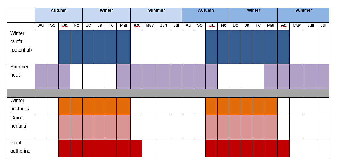 Figure 25 – Suggested seasonal exploitation of the Gilf Kebir in Gilf C
Both Wadi el-Akhdar and Wadi el-Bakht were littered with tools, and were both taskscapes in Ingold’s sense of “an array of related features and associated tasks” (Ingold 1993, p.158). Given the lack of a use-wear database for Egyptian material (Shirai 2015, pers.comm.) and the general lack of clarity about what various tools were used for in prehistory (Shea 2013, p.44, p.292-4), it is difficult to assess the assemblage in purely functional terms. However, McHugh (1975, p.49-50) suggests, tentatively, that as tools were becoming larger with new types being introduced into the toolkit, they represent wood working tools (notched and denticulate items, making up 21% of his sample), plant harvesting tools (long and serrated blades), cutting and severing (simple retouched blades, backed blades and bladelets), bone working (burins) and preparing and working animal skins (scrapers and borers). Hunting tools are poorly represented and it is entirely likely that techniques and game chosen may have changed along with a change in animal species present after the establishment of the environmental conditions of the mid-Holocene.
It can be safely concluded that groups moved into the area when rainfall was available, stayed with their herds whilst water remained in the ground long enough to provide pasture and hunting resources, concentrated progressively on the basin area when pasture began to dry up and intensified plant use as hunted prey became depleted, and moved away with herds.
Capital Assets
In modern pastoral economies livestock are the primary form of capital used in exchanges for everything from craft and food produce to brides (Ryan et al 2000, p470). In the Gilf C the remains of cattle, sheep and goat have been found, as well as wild fauna. It seems likely, given the distances over which these groups travelled, that such negotiations would have taken place at organized events and important events like funerals (Cliggett 2005). Formal transactions between modern herders include loan of animals, renting of animals, gift of animals and exchange of animals, cloth, basketry, foodstuffs etc (Swift 1975). Livestock can be assets held simultaneously by the community, in the form of herds, and by the household, in the form of individual animals. They can be loaned out in various arrangements that express highly complex relationships and contracts between the lender and the borrower.
Animal diseases, viruses, pests and parasites
Due to the lack of osteological data there is no direct information on this matter. The Gilf Kebir was north of the tsetse front, so this would not have been a risk, and it can be assumed that tsetse zones would have been avoided during nomadic movements. Retreating water, increasingly stagnant, may have become a breeding ground for disease-carrying parasites (Mainguet 2010, p.210)
The potential for, and indications of, trade networks
In modern pastoral economies livestock are the primary form of capital used in exchanges for everything from craft and food produce to the acquisition of marriage partners. In the Gilf C the remains of cattle, sheep and goat have been found, as well as wild fauna may have been employed as capital for exchange. It seems likely given the distances over which these groups travelled, that such negotiations would have taken place at organized events and important events like funerals (Cliggett 1995) and during aggregation of different groups at Jebel Uweinat. The most obvious area for potential for trade locally between mobile households or groups, are domesticated animals, dairy products, and ceramics. Other objects like basketry, cordage and leather goods have not been preserved but may have been of value for swapping goods. Bearing in mind Summerhayes’s warning that trade or exchange “must be demonstrated rather than assumed” (original italics, Summerhayes 2015, p.482), this section can only suggest which items may have been eligible for trade, if trade is practiced.
Ceramics are an obvious candidate for exchange both between households and between groups. Unlike lithic technology which can be learned very easily from childhood (Edmonds 1995, p.37, 40), a certain amount of knowledge and skill is required and may be restricted to certain families or households (Arnold 1985; Balfet 1965; Needler 1984, p.184; Rice 1987, p.183-191). However, there is no sign of specialized production. It seems likely that pottery was produced by each group as required, rather than traded, although vessels may have been used to exchange products contained within them.
Lithics are not suitable for trade, due to the opportunistic and unskilled nature of the production technique and resulting forms, but livestock, dairy products and marriage partners are all potential items for trade. Services like labour, religious expertise and middle-man type roles may also have been of value in reciprocal negotiations and exchange agreements.
Investment, savings and credit
One of the significant differences between hunting and herding livelihood systems is that whilst hunters may negotiate rights to land and certain key resources including food and water, herders introduce the concept of livestock ownership and scheduling into the mix (Marshall and Hildebrand 2002, p.112), which may be particularly challenging when hunting is still a part of the subsistence strategy, due to potential conflicts in scheduling. Scheduling of movement to accommodate herds and the increasing intimacy of the relationship between people and animals would have had to fit in with hunting activities, craft material collection, plant food collection, and raw material resource acquisition (Hurcombe 2014; Marshall and Hildebrand 2002, p.112; Marshall and Weissbrod 2011, p.402). As well as providing an immediate source of meat and dairy products, livestock provide the added benefit of providing storage on the hoof. By converting cellulose plant materials that humans cannot digest into meat and by reproducing, livestock store nutrients that, unlike other forms of consumable material, can be moved easily from one place to another without the need for transportation. The occupants of the Gilf Kebir during the Gilf C period, who herded cattle, sheep and goat, provided themselves with a good combination of plant conversion potential. As well as meat, livestock represents renewable stores of fat, dairy and blood, as well as non-renewable stores of bone and hides. During the Gilf C the ability to store meat was improved by hunting and consuming wild livestock rather than undermining the herd by consuming the stored products. Herds may be owned by an individual, family or group, but they represent investment of labour and resources, and can be bought and sold either dead or, more probably, alive. Different species represent different levels of investment and return. At the simplest, they provide meat, fat and dairy products. At a more complex level, with a six month gestation period for sheep and goat, and a nine for cattle, and with litters rarely exceeding one individual for cattle and two individuals for sheep and goat, livestock represent an investment both in the present and in the promise of future returns (Marshall and Hildebrand 2002). Ownership may confer status and influence upon their owners and produce ideologies of wealth. Amongst the northeast Sudanese Beja, goat and sheep are both kept, are used for milk and (in the case of goat) for making clarified butter, are eaten when guests arrive and on ceremonial occasions, and are sold to obtain household products (Manger et al 1996). Livestock is therefore a very flexible investment.
Credit, the ability to borrow, is a significant feature of risk management in nomadic pastoral communities, where the build-up of inter-dependability between the different factions that make up larger kinship groups can be used in times of difficulty. Livestock may be loaned to family members, and frequently are (Bates 1971, p.139-40; IFAD 2004, p.15-16; Manger et al 1996), becoming a basis for future reciprocation and the reinforcement and refinement of relationships. The existence of kinship groups is a universal feature of herders, and it seems reasonable to assume that such relationships existed in prehistory. Linkages between Gilf C groups and other areas are suggested by lithics and pottery and are discussed below, but indicate that connections did exist between groups over a wide area. However, there is no evidence that this was taking place, mainly because there are currently no archaeological measures for such a relationship.
Labour
Herding and hunting were ongoing activities, with hunting usually requiring more in the way of knowledge and strategy than high numbers of people for labour, unless animals need to be provided with water drawn from wells (Grandin et al 1991). Roe cites one shepherd to 200 ovicaprids amongst the Awlad Ali semi nomadic herders of Siwa Oasis (Roe 2008, p.494). Plant gathering is a more intensive activity, requiring the gathering of a substantial amount of plant foods to feed a community, particularly if seed is a particularly important part of that plant intake. A herding and hunting economy requires sufficient labour to maintain the herd, to search for and process food and plant resources and to manage household activities. The table below (table 7) shows Schareika’s analysis of the Woɗaaɓe of the northeastern Niger (Schareika 2003, p.16), showing the levels of daily activity required for maintenance of even a small herd.
| Time of the Day | Herd Activity |
| Just before sunrise | Inspecting the herd |
| After sunrise | Milking the cows; freeing calves from calf rope |
| Morning hours | Morning pasture |
| Noon | Cattle rest; calves separated from herd |
| Afternoon hours | Afternoon pasture, sometimes without herder |
| Late afternoon | Calves tethered to the calf rope |
| Early evening | Herd comes back from pasture; lighting herd fire |
| Before sunset | Milking the cows |
| Before sleep | Tethering older calves to the calf rope |
| During the night | Night pasture, only supervised when in the vicinity of fields |
Table 7 – Herders’ daily routine (Schareika 2003, p.16, Table 1)
In table 7, putting the herds out to pasture “is an acitivity that supplies the animals with grass, browse and water, and structures their own and the herders’s daily routine” (Schareika 2003, p.13). As water is essential for the health of the herd and particularly for lactating females (Little and Leslie 1999, p.12) water provision would have been a major part of both the daily and seasonal rounds. Where multiple groups use the same pastures and water sources this is also the time when herders and their livestock come into contact with others, exchanging information and negotiating access to limited resources (Cligget 2005, p.81-83; Bollig 2009; Johnson 1999). Towards the end of the seasonal occupation at Nabta it is possible that animals would have been watered manually as the lake evaporated and the water table dropped and had to be extracted from wells (Kobusiewicz 2003, p.97; Schild and Wendorf 2001b, p.47).
Although the Gilf C sites were considerably smaller than the Gilf B sites, they are well represented and suggest that sufficient labour was available for all the subsistence tasks being undertaken, both in the wadis and on the plateaus. The pattern of camps changed from Gilf B from centralized camps from which expeditions departed to other areas, to a pattern where multiple camps were employed in conjunction with each other, combining longer term base camps and shorter term ateliers, from which herders and other task groups departed (Linstädter, J. 2003a). The network of sites seems to have been far more complex than in Gilf B, reflecting the greater number of activities being carried out.
Depending on the form of mobility, it is possible that part of the community remained at Jebel Uweinat whilst other members of the group took their livestock to pasture, a model used by some modern pastoralists (Belal et al 2009; Wendorf and Schild 1980, p.270). This would have a second benefit of retaining a hold on any resources connected with the group at Jebel Uweinat or elsewhere, whilst taking advantage of seasonally available resources at Gilf Kebir, and using the move to Gilf Kebir to restock quartz from the plateau. It is possible that women and some children and young stock were left behind whilst men and older children remained behind. The highly ephemeral nature of the Gilf Kebir camps might support this; unfortunately it is not known if there are correspondingly larger occupation sites in the Jebel Uweinat to support this proposal.
Specific task groups appear to have been responsible for sourcing and extracting raw materials on the plateau (Linstädter 2003; Linstädter 2005e) indicate a certain division of labour. The less specialized tool kit required much less manufacturing skill and time, but raw material acquisition seems to have been of particular importance, with brief workshop camps being established on the plateau to make use of quartzite outcrops.
The balance between hunting and herding activities would have required sufficient labour to form task groups to manage both sides of the livelihood, and in hunting prioritization is likely to have taken place between low value and high value targets. Combining the specialized requirements of herding with the different strategies required by hunting it is likely that the livelihood was not always particularly symbiotic and may have required the splitting of the group into herding and hunting parties, perhaps with specialists in each area necessary for the successful sustainability of the community as a whole. If herds also had to be split in order to make best use of the topography and the variable resources, this too would have required labour. For example, it might have been laborious and risky to take cattle onto the plateau, but goats, which are naturally sure-footed and will tolerate some deprivation of water, will have been easier to herd onto the plateau to take advantage of occasional pasture and pools of water.
The less specialized tool kit required much less manufacturing skill and time, but raw material acquisition seems to have been of particular importance, with workshop camps such as 99/53 (Claßen and Pastoors 2005) being established on the plateau to make use of quartzite outcrops.
Knowledge and Information
The Gilf C represents considerable local knowledge, not just of rangeland potential and water sources but also of physical topography and raw materials. Many writers emphasise the value of local knowledge and the role it plays in the movement of groups, the placement of camps and perception of given landscapes (e.g. Berkes 2012; Hurcombe 2014; Ingold 2011; Kenmare 2003; Schareika 2003, 2014; Turton 2011, p.167). Turton, for example, describes how local Mursi in southwest Kenya have “customized” their landscape and environment in response to their own specific needs (Turton 2011, p.168), using highly specific and rich knowledge to make use of chosen areas for daily activities. B.D.Smith (2011, p.263) suggests that small scale groups will develop “high-resolution cognitive maps of the seasonal habitat preferences and spatial distribution of a wide variety of high value target species of plants and animals” based on experience from repeat visits. Berkes et al (2000, p.1252) discuss how this type of livelihood knowledge is tested by trial and error and conveyed to new generations and involves both management practices based on ecological experience and the social mechanisms that underpin them, including knowledge management, internal institutions and numinous traditions (Berkes et al 2000, p.1253).
In the Gilf Kebir this demonstration of local knowledge is visible, even without plant remains to complete the picture, supporting Hunn’s statement that continued use of an environment leads to reinforcement of knowledge and higher chances of sustainability and survival (1993, p.13). The use of the plateau for pasture argues a firm ability to assess quality and quantity of rangeland potential in order to optimize the health and fertility of herds during the rainy season, requirements emphasized by Schareika (2003, 2012) and Kenmare (2003, p.v-vi). The expansion of well-defined campsites onto the plateau in Gilf C, when it had not been used in Gilf B, demonstrates the enterprise of herders to extend into new territory when it becomes available. Rock art, as part of a cultural structure for reinforcing traditions, becomes part of this transmission of knowledge. Some campsites are directly related to raw resource acquisition. Quartzite was the dominant form of stone employed during Gilf C and the plateau was a good source of it, with campsites appearing alongside workshops (Linstädter 2003).
The potential of information exchange is focused on the Jebel Uweinat, where different groups may have occupied the area simultaneously. The type of information that would have interested groups would have been real-time, focusing on where vital resources like pasture and wild herds were to be found, the movements of other household s and groups and events of note (such as rites of passage, funerary activities etc.) were to take place and the transmission of skills concerning new economic and technological techniques and methods.
As Belal et al point out, when economic activities are dynamic, knowledge must adapt to circumstances and opportunities (2009, p.121) and amongst the groups who inhabited the Gilf Kebir there may have been the need to respond not merely to changes in the environment but to encounters with different groups and their herds in shared territories, adapting their knowledge as needed in a very dynamic world.
Mobility
The Gilf C represents mobile groups, who not only moved between areas but within them. On the basis of comparisons with other groups who practice mixed herding in similar conditions today, it is probable that herds would have to have been moved throughout a wide area to make the best use of the marginal quality of the dryland vegetation in the area (Leloup, n.d.; Niamir-Fuller 1991; Niamir-Fuller 1998). High residential mobility would have been required to prevent depletion of resources at both locations, and it is likely that both areas were involved in a wider round of exploitation that could have involved other groups as well, all using Jebel Uweinat and travelling to different areas from there.
Within each locale, the Gilf Kebir and Jebel Uweinat, it is probable that a high degree of logistical mobility was practiced, and this is certainly suggested by the Gilf C the network of large base camps within the wadis and, both large and small camps and ateliers proposed by Linstädter (2003). Kröpelin (2005, p.61-62) makes a strong case for Gilf inhabitants occupying Jebel Uweinat on a “seasonal, periodic or episodic basis” suggesting that Karkur Tahl in northeast Uweinat is the most obvious area, due to its proximity and its optimal conditions. The point made by Sheller and Urry that “all mobilities entail specific, often highly embedded and immobile infrastructures (2006, p.210) seems to be borne out by this pattern of land usage at the Gilf. The Jebel Uweinat, the most important of the two highland areas from both an economic and a symbolic point of view, had extensive resources available, including permanent spring waters, orographic rainfall (the Jebel Uweinat reaches a height of 1900m asl), diverse wildlife species present favouring both wadi and highland zones and the certainty of rich plant remains in favoured locations, particularly wadi bottoms. Even today the Jebel Uweinat is remarkably rich in animal and plant species (Osborn and Krombein 1969). Jebel Kamil, less than 50km to the southeast of the Gilf Kebir, was a smaller upland area, but has also used during Gilf C.
Gilf C artefacts indicate the areas with which the Gilf C groups had connections, whether direct or indirect. These include Laqiya to the south, Abu Ballas to the northeast, Tibesti to the east and Laqiya to the southeast and, by extension, the Nile at Abka. (Fäder 2005, p.182; Kuper 1993, p220; 2007; Kuper et al 2009a; Lange and Nordström 2006; Linstädter 2005g; Linstädter 2007; Wagner 2005). Further afield connections with the rich late Neolithic archaeological areas of the Sudan have been proposed (Kuper 2007; Linstädter 2005g; Schön 1996a, p.128). Lenssen-Erz and Linstädter (2010) suggest that the territory used by the Gilf C groups may have covered some 40,000km2. It is also possible, however, that these similarities are part of a network of communications rather than evidence of direct contacts.
Riemer (2009) discusses the occurrence of Gilf C herringbone-decorated sherds at Gilf Kebir in Wadi el-Akhdar and Wadi el-Bakht. Between them these suggest links with Laqiya in northern Sudan to the south, Abu Ballas 150km to the northeast, and Jebel Kamil, less than 50km to the southeast. The various pottery types commonly produced in the Gilf C period have affinities to, although are not identical to, types produced in the Nile valley, to the south in the Wadi Howar and the west, in the Tibesti region (Linstädter 2007). Riemer (2007b) suggests that the desert areas were used along specific routes, between specific nodes, due to the change of climatic conditions and the need to move between reliable sources of water and pasture, but at the same time scheduling of movements would have had to have been flexible to the high variability of rainfall, both temporally and geographically (Marshall and Hildebrand 2002, p.112). The requirement to find pasture for herds and to include craft requirements (Hurcombe 2014) and hunting and gathering activities means that the Gilf C groups will have needed to be flexible about moving whenever droughts reduced pasturage. Unlike exclusively hunting communities, pastoral groups need to find water for herds. Unlike wild animals, many species of which can take their water requirements from vegetation, domesticated livestock require water. Cattle, in particular, are heavy consumers of water and must be moved to wherever there are sufficient sources. Zboray concludes that the rock art provides “conclusive evidence that the cattle pastoralist people roamed across the entire region encompassing Jebel Uweinat, the surrounding smaller massifs and the Gilf Kebir plateau” (Zboray 2010, p.224). If the Jebel Uweinat and Gilf Kebir made up a single territory they would have involved a 40,000km nomadic course through the year (Riemer 2010, p.181) and groups may have additionally extended further afield.
Gabriel does not state whether any steinplätze have been found in the general area, but they are a phenomenon of the Sahara, which he argues are probably associated with herders making use of shallow depressions with accumulated water for short periods of time on the plains beyond highland areas (2002, p.55, p.59-62) and it would be useful to survey for these in the lowland areas around the Gilf and Jebel Uweinat with a view to detecting any signs of usage of the plains for herding and to detect routes between principal nodes.
Different rates of mobility will have existed within the larger scheme of annual movements, with herding, hunting, gathering plant foods, engaging with different topographies, establishing camps, acquiring raw materials, building monuments and carrying out everyday tasks like butchery, tool making, milking and cooking each having their own dynamic structure within the seasonal round. A mobile lifestyle involved continual dynamism.
Given that the Gilf could only be used during and for a short duration after rainfall, it is possible that a transhumant logistical mobility was practiced, a model of land use that is quite common among modern pastoralists like the semi nomadic Fulani (van Raay 1975). Large base camps during the Gilf C suggest that a number of households could have been resident at Gilf Kebir, but the data is not sufficient to be able to assess this. It has been proposed that between the two, Gilf and Uweinat, year-round occupation was possible (Kröpelin 2005, p.62; Linstädter 2007), but given that Jebel Uweinat may have been an aggregation zone (von Czerniewicz et al 2004), this would have run the risk of over-exploiting resources, and it is probable that longer distance mobility would have required, and even preferred. The Borani and Woɗaaɓe models of perpetual movement (Binns 1992; Schareika 2003) may apply in this case. The Woɗaaɓe believe that constant roaming is essential to herding society and livelihood, and movement takes place both between camp and pasture and between one pasture and another. A combination of residential and logistical mobility enables them to move every two to ten days (Schareika 2003, p.13). Other plausible models are those of the G/ui and G//ana where groups depend upon rain-filled depressions in the central Kalahari for up to two months in the rainy season and then disperse into smaller family sized groups in the dry season (Hitchcock and Ebert 1989; Sapignoli 2014, p.44).
The Gilf Kebir dune lakes evidently offered sufficient water for the herds that were repeatedly brought there throughout the seasons, whilst the plateau offered pasture and raw materials. Movement between these resources seems fairly self-evident from the distribution of sites over wadi and plateau areas, as well as a much smaller number on the plains immediately below, where water may have gathered and pasturage may have grown.
A paper by Böckli and Marai (2008, p.143) proposes that at Jebel Uweinat, with findings of Cattle Herders style rock art at 930m, 1235m and 1425m suggest vertical as well as horizontal transhumance. This argues that during the Gilf C period, as well as using the plateau, wadis and the plain, there was potential for using much higher ground as well, making the best use of all available topographies. Reserve pastures for drought seasons need to be maintained today where any occupation of an area is semi-sedentary or where repeat use of a relatively confined area is sustained (Igoe 2006; Tache 2010). Reserved pastures are often in areas that are more difficult to access due to the terrain.
Land Tenure
There is very little differentiation between artefact scatters. This might be indicative of similar livelihood strategies but may also suggest that the groups using the Gilf Kebir were part of the same community, were known to each other, and were not in conflict. As Campbell et al (2006, p.79) point out, property rights influence access to resources and add another dimension to temporal variability, leading to new patterns of negotiation for access to land and water. Decisions about when and where to move will have been based not merely on preferred locations and the availability of resources but on the claims to resources that have already been made and the value of the land in ideological terms (Sapignoli 2014, p.42). The rights to the water and surrounding resources of the Gilf Kebir may have been restricted to only a few groups, or it may be that the resource was only known to a few groups. The homogeneity of the assemblage, in so far as can be observed in the palimpsests that make up the dataset, and the similarity of rock art forms throughout the area suggest that there were no signs that there groups using the area shared a common cultural heritage and were not in conflict over land. However, it is likely that as vital resources became increasingly sparse towards the end of the period, land usage arrangements became formalized, as with pastoral groups today (Binns 1992; Dey 1981; Manger et al 1996).
Wobst suggests that rock art is used as a way of reinforcing social control when there is dispute or competition: “The more cave art, the more things would have been in contest, the stronger the social control to be constituted by this material interference and the stronger the potential for resistance (and thus for mutual interferences in each other’s social actions” (Wobst 2000, p.47). This idea is supported by the findings of Lenssen-Erz in Chad, who has suggested that rock art corresponds to different ethnic groups and their territorial occupation of different parts of the Ennedi highlands (Lenssen-Erz 2012). Whilst this type of research into rock art in the Gilf Kebir and Jebel Uweinat are still in their early stages, it is entirely likely that between the two areas rock art was as much a part of identification with certain areas as it was with numinous activities.
3.1.5 Human Assets
Potential nutrition
The objectives and limitations of reconstructing nutrition from raw data and the basics of human nutritional needs have already been discussed and duplicated in the previous case studies and will not be repeated here. This section represents the optimal nutritional possibilities that are represented by the archaeological data. The following tables look at the complete data that we have for the Gilf C. Unfortunately, it is not sufficient to form a view on the potential health of the Gilf C inhabitants, but does indicate some of the nutritional components that may have been exploited. The relevant animal and plant species are shown in tables 8 and 9.
| Nutritional Values of Plant Species
|
|
| Species
|
Value |
| Balanites aegyptiaca | Evergreen tree. Up to 8m high with edible, bitter-sweet fruit, which is rich in rich in phosphorous, potassium, calcium, iron, zinc, copper, sodium, magnesium and manganese. In some areas seeds are crushed to make oil (Feyssa et al 2015; Mahmoud 2010, p.45; Van Wyk and Van Wyk 2013, p.438) |
| Maerua crassifolia | Small sweet pale green fruits are edible (Mahmoud 2010, p.96). Fruits are valued by the Bedouin for their sweet taste and they are a good source of nectar for honey. Leaves are a good source of calcium, linoleic acid and alpha-linolenic acid. |
| Tamarix sp. | Fruit is used by the Ababda of the Wadi Allaqi (Belal 2009, p.68). It is traditionally used for medicinal purposes. |
| Ziziphus spina-Christi | Fruits are a good source of vitamin C (Arndt et al 2001) and are traditionally used for medicinal purposes. |
Table 8 – Nutritional values of plant species in the Gilf C
Grinding tools, present in great numbers, suggest the processing of wild cereal grains, which will have provided carbohydrates, most of the B vitamins, some proteins and potassium.
| Nutritional Values of Animal Species
|
||
| Species
|
Seasonal availability | Value |
| Cattle | Dairy products: Only when animals are lactating (3-8 months)
Blood: available all year round but less during dry-seasons and not at all during drought Meat; at any time |
Dairy products: Calcium, Vitamins A, D, zinc, phosphorous, fat (4-5.5%), carbohydrates
Blood products: Iron, zinc, protein, some calcium and phosphorous Meat products: protein; fat; folate/folic acid; Vitamins A, B2, B3, B6, B12 |
| Gazelle | At any time | Meat products: protein; iron, zinc |
| Goat | Dairy products: Only when animals are lactating (3-8 months)
Meat; at any time |
Dairy products: Calcium, Vitamins A, D, phosphorous, zinc, fat (3.5%)
Meat products: protein; iron, zinc, vitamins A, B2, B3, B6, B12, D, carbohydrates |
| Ostrich | Meat: at any time
Eggs: winter |
Meat products: low in fat but is high in protein, vitamin B12, selenium, niacin, vitamin B-6, phosphorus and zinc and smaller but significant levels of thiamin, riboflavin, pantothenic acid, iron, potassium and copper
Eggs: high in fat and contain vitamin A, thiamine, zinc, calcium, iron, magnesium and manganese |
| Sheep | Dairy products: Only when animals are lactating (3-8 months)
Meat: at any time Blood: at any time |
Dairy products: Calcium, Vitamins A, D. phosphorous, zinc, fat (5%)
Meat products: protein; fat; folate/folic acid; Vitamins A. B2, B3, B6, B12, D, carbohydrates Blood: Protein, iron, salt |
Table 9 – Nutritional values of animal species in the Gilf C
As outlined in Appendix C, it seems very likely that one of the main values of cattle and ovicaprids is that their milk could be consumed, in spite of the possibility of lactose intolerance. Although there is very little direct evidence for dairying in the eastern Sahara, Gilf Kebir rock art shows cows with full udders, and a recent paper in Nature identified dairy remains in ceramics from Libya (Dunne et al 2012). It seems more than reasonable, therefore, to assume that the Gilf Kebir herders were using their cattle for milk and producing dairy products. If dairy was not consumed due to lactose intolerance, the outlook becomes less clear-cut, with much greater effort needed to obtain calcium, saturated fats, vitamin A and vitamin D.
Gautier’s discussion of the value of animals in purely dietary terms for Nabta Playa is applicable here too: “if we turn to dietary ratios, it becomes clear that livestock contributed substantially more to the diet, because the live weight and hence dressed carcass weight of sheep or goat (50kg?), and cattle (250g?) exceed markedly that of gazelles (20kg).” (Gautier 2001, p.632). Hassan’s analysis of the comparative values of different species in a study of Late Palaeolithic Dishna Plain (1974, p.152-154) compares hare, which on average weighs 1.5kg and produces only 0.75kg meat with gazelle, which weighs on average 22kg and produces 11kg meat. In all cases there is potential for meat intake, but the domesticated livestock far exceed the available wild species in terms of their potential contribution to the diet.
Ziziphus continued to grow, again providing vitamin C, and the number of grinding tools on the sites suggests that wild grains available to provide carbohydrates, most of the B vitamins, minor levels of protein and potassium.
Between the meat and plant products it should have been possible for Gilf C inhabitants to eat a balanced diet in the wet season, and may have escaped the perils of a “hunger” season (Cliggett 2005) by exploiting the natural springs of the Jebel Uweinat to the south in the dry season and by moving herds to other areas to allow pastures in the Jebel Uweinat to rest.
Evidence of physical condition
Without any skeletal data there is no evidence for the physical condition of people during Gilf C. Degen points out that few, if any, precautions are usually taken in the milk and dairy production process (Degen 2007, p.7-8) and it is possible that with the adoption of domesticates for milk as well as meat in may have resulted in new health risks due to lack of hygiene in dairy product manufacture.
New modes of mobility and the association with retreating pools of water, with stagnant water left in certain margins of these wet areas, may also have come with their own risks.
Medicinal components
A number of species that are used today for medicinal purposes could also have been employed in the past. Phragmites communis, for example, has been used to treat bronchitis and cholera whilst leaf ash can be applied to infections (Van Oudtshoorn 2014, p.112). Acacia nilotica produces pods with seeds that are used by the Ababda of Wadi Allaqi for treating coughs (Belal 2009, p. 78). A decoction of Maerua leaves can be used for toothache and intestinal diseases (Mahmoud 2010, p.96), whilst Balanites is used as an antidiabetic (Mahmoud 2010, p.45). A decocotion of Ziziphus leaves can be used to treat colds, hypertension, and stomach complaints (Mahmoud 2010, p.13).
Skills and knowledge
Animal herding and husbandry require a specialized knowledge, and given that the Gilf C period lasted for nearly 1000 years it seems clear that there were no difficulties with the exchange and communication of this knowledge. Although lithic technology was less specialized, it still required basic skills, and this was evidently maintained over the same period. It is not known whether pottery was manufactured or purchased.
Task groups assigned responsibility for sourcing raw materials on the plateau, which were then reduced to blanks and cores prior to transportation, indicates a certain amount of specialization within the group.
In the above section on nutrition the assumption as made that knowledge would be transmitted from one generation to the next about what was available in the natural environment for nutrition. Here, the question of the transmission of skills and knowledge to ensure well-being for all people within households and the larger group in the Badarian are assessed. Although much knowledge may be transmitted with ease between generations, specific technological skills may require more investment, and the different levels of skill, and the associated knowledge transmission, are considered.
Stone tool manufacture is not a difficult skill to learn, and there are no specialized skills and techniques that would have required particular knowledge beyond that learned in childhood.
Pottery production, on the other hand, was very accomplished and seems to have lasted throughout the Gilf C, as described in the Physical Asset section, arguing for an accomplished transmission of knowledge and skill, which would have required not merely technical skills, which were probably easily transferred between generations, but also cultural ideas that were incorporated into the pottery design and decoration.
Bead production is a skilled craft, but like lithic tool manufacture, could be learned from childhood without a strong investment in transmission of knowledge. Today it is often carried out by women and is taught by those women to their daughters.
Sex
Without burial evidence it is not possible to speculate about the gender mix available within the Gilf C populations. It is quite likely that there was a much greater division of labour now that the livelihood system was more complex, with men, women and children taking on different areas of responsibility both close to settlements and further afield, and that social networks would have helped to sustain the availability of marriage partners.
Age
See Sex, above.
Population numbers
At the moment it is unclear which sites were occupied contemporaneously. Further radiocarbon dates will help to clarify the picture and to enable estimates of the numbers of individuals using the Gilf Kebir area at any one time.
Gene pool
The linkages suggested by hand-grinders, ceramics and Libyan Desert Glass suggest that the Gilf C groups had connections over short distances to the north and much greater distances to the south, implying that their kinship group and wider contacts would have enabled them to refresh the gene pool on a regular, probably annual basis if required (Kuper 2007; Lenssen-Erz and Linstädter 2010; Riemer 2007). The potential fluidity and porosity of these types of community, discussed in the Nabta case study, would give opportunities for marriage partners outside the immediate groups, either within the broader kinship group or beyond it with different ethnic entities (Kusimba 2003, p.85).
3.1.6 Personal Assets
Personal well-being
Indicators of economic sustainability, social networks and a religious or ideological component suggest that there was the potential for well-being.
Security
The adoption of domesticates appears to have provided a level of livelihood security for the Gilf C groups who used the area in a context of unpredictable rainfall but secure artesian springs. Towards the end of mid-Holocene food security and territorial security may have been under threat, and individual status and personal security may have been considerably undermined.
Ability to gain status and influence decisions
There is little to identify individual status in the Gilf Kebir. It is likely that as the group shifted location different people became important at different times, and that individual roles became prominent on a seasonal basis. Most pastoral societies include a number of individuals in decision-making processes (e.g. Schareika 2014) and it can be proposed, on the basis of the complexity and social arrangements that decisions were required on an ongoing basis and that there were multiple participants involved. The adoption of domesticates and the introduction of livestock ownership as a new concept may have given individuals access to status via a) livestock ownership and b) the ability to demonstrate and action ecological and herd management knowledge. However, there is currently no data to support this.
4.0 The Livelihood Variables
 Figure 26 The Livelihood variables section of the SRL Model, outlined in red
The Livelihood Variables (figure 21) are made up of three major areas of influence: the Vulnerability context, Opportunity and Livelihood Structures and Processes. These are the variables that act on the Livelihood Assets, and are discussed below.
4.1 Vulnerability Context
The most obvious areas of potential vulnerability are stochastic conditions in the mid-Holocene, leading to geographical and temporal variation in rainfall and the availability of pasture during the rainy season. The Assett Matrix captures many of the important features of a community, but all the components that make up the matrix are dynamic and in a constant state of flux. After the end of the Gilf B2, the early Holocene rainfall regime changed and the Gilf area now received, instead of large quantities of heavy monsoonal rain in short bursts, a more evenly distributed lower level of winter rainfall, now falling in the winter, which is thought to have fallen at night. The lower levels of evaporation and the more even distribution of rainfall during the wet season benefitted the Gilf area in terms of vegetation and the wildlife that it attracted. Towards the end of the Gilf C, the Wadi el-Akhdar was abandoned in favour of the Wadi el-Bakht, and it is suggested (Kröpelin 1993b; Gehlen et al 2002) that the dune barrier may have been breached at this time, draining the wadi of its water. The playa lake sediments of the Wadi el-Akhdar have not been examined in detail, so this is not yet confirmed, but seems like a reasonable explanation for the abandonment of the wadi at this time. At the end of the Gilf C, the Intertropical Convergence Zone moved further south, bringing an end to the settlement of the drylands in many eastern Saharan areas. A breach of the Wadi el-Bakht barrier dune, the key benefit of the Gilf Kebir during the Gilf C, brought the usefulness of the area to an abrupt end. It seems fairly safe to conclude that the main form of vulnerability following this set-back was the the continued southward movement of the ITCZ, a trend that began at the end of the early Holoccene. This began to transform rainfall regimes and increasing unpredictablility of rangeland availability. As Nelson et al state (2016, p.298) “Managing disasters, especially those that are climate-induced, call for reducing vulnerablilities as an essential step in reducing impacts” and the task for those who abandoned the Gilf Kebir at this time was to create conditions in which risk was balanced by new strategies. These might include new economic systems based around herds and new social systems based around the Jebel Uweinat, and more humid areas to the south, as well as the nodes within and routes through them.
The system developed by Nelson et al described in Chapter 2 is used to gauge other vulnerability in access to food will be used to give a top-level assessment of the food resource situation at Nabta Playa. The variables are ranked using a simple qualitative scale to measure its contribution to overall vulnerability. The variables contributing to vulnerability load are shown in the table 10 (Nelson et al 2016, p.300):
| Vulnerability variables
|
Evidence for vulnerability | Value for variable for resilient food system | |
|
Population-resource conditions |
|||
| V1 | Availability of food and water | Insufficient calories or nutrients | Balance of available resources and population reduces risk of shortfall |
| V2 | Diversity of available, accessible food and water | Inadequate range of resources responsive to varied conditions | Diverse portfolio reduces risk, increases options |
| V3 | Health of food resources | Depleted or degraded resources, habitats | Healthy habitats, contribute to managing risk and change |
|
Social conditions
|
|||
| V4 | Connections | Limited connections with others experiencing different conditions | Social networks expand access to food and land |
| V5 | Storage | Insufficient, inaccessible storage | Stored foods reduce risk in times of shortage |
| V6 | Mobility | Inability to move away from challenging food conditions | Movement to alternative places, landscapes and social groups offers potential for addressing resource shortfall through access to food/land |
| V7 | Equal access | Unequal control and distribution of land, water and food resources | Equal access avoids challenges to coping and adaptive capacity in disaster risk management |
| V8 | Barriers to resource areas | Physical barriers limiting access to key resource areas | Lack of barriers enhances capability of people to provision themselves with food |
Table 10 – Vulnerability indicators, based on Nelson et al 2016
The qualitative ranking scheme is as follows for measuring each variable, based on contribution to vulnerability (2016, p.300):
- No contribution
- Minor contribution
- More substantial contribution
- Substantial contribution
A score of 1 for varible 1 (availability of food) would indicate that food supply did not contribute to vulnerability and would not therefore be a problem for the community. A score of 4, however, would indicate high vulnerability. A total of all variables (a possible maximum of 32) gives an estimate of how vulnerable the entire community was. By dividing vulerability into resource and social conditions, the importance of natural versus human influences can be made explicit. I have divided the outcome into two rows: “Data,” which reflects what the actual data indicates, and “Extrapolated,” which uses the combined knowledge derived from the case study and ethnographic studies to suggest more realistic scores. Question marks represent insufficient data. The variables for each case study, using best judgement best on the data captured in the assets are as follows in table 11:
| Population-resource conditions | Social conditions | Total | |||||||
| V1 | V2 | V3 | V4 | V5 | V6 | V7 | V8 | ||
| Data | 4 | 3 | ? | 2 | ? | 1 | ? | 1 | n/a |
| Extrapolated | 3 | 2 | 2 | 2 | 4 | 1 | 4 | 2 | 20 |
Table 11 – Estimated vulnerability measurements for the Gilf C
V1: High localized and more regional mobility suggests that food and water availability will have been fairly dependable in good (sufficient rainfall) years, particularly as the Jebel Uweinat had permanent and reliable water sources in the form of both springs and orographic rainfall. In years where drought or disease were prevalent this would have been far more unpredictable. As the mid-Holocene was probably characterized by stochastic variation, the availability of food is likely to be an area of potential vulnerability.
V2: The data for food consumption is far from definitive, particuarly in terms of volume, but a mixture of cattle, sheep and goat as well as wild species, and the presence of grinding equipment suggest a diversified diet, supported by mobility and the use of different topographies.
V3: Data for environmental conditions and the practice of residential or logisitcal mobility argue for good environmental management in the Gilf Kebir area, reducing the potential for overall risk. The dune barriers were an inherent risk. Both Wadi el-Akhdar and Wadi el-Bakht were eventually breached. Whether this threat was percieved until the breaching of Wadi el-Akhdar is impossible to know.
V4: The indications are that the Gilf Kebir inhabitants were connected to people over a wide area, which may have provided withm with support mechanisms during times of difficutly and provided access to goods, social events and marriage partners.
V5: There are no indications of storage at the Gilf Kebir, which suggests that apart from domesticated animals there were no resources stored against future difficulties.
V6: Mobility was one of the key strenghts of the Gilf groups in reducing vulnerability. Groups were mobile in the immediate area of base camps in both wadis and on the plateau, were apparently present in the Jebel Uweinat and there are indications that they were mobile beyond the Gilf/Uweinat area.
V7: Although there is no evidence for competition of resources in the Gilf area, there is evidence that many groups converged upoin Jebel Uweinat, which formed part of the mobile territory of the Gilf occupants. It is likely that land and water access was under tight control, but at the same time this may have been an area of vulnerability.
V8: There were few physical barriers throughout the Gilf C period. At the end of the Gilf C period the desert itself may have become a barrier.
In conclusion, potential vulnerabilty was high. Mobility and diversification, together with long distance social networks and an absence of serious physical barriers to food provisioning were all strong features in the management of vulnerability, which was itself caused by environmental flux and the southward movement of the Inter-Tropical Convergence Zone.
4.2 Opportunity
The main signs of differentiation from the Gilf B, suggesting that new opportunities in th eform of adopted or pristine innovations were taken up are as follows: 1) are the commitment to the use of domesticates, 2) new types of rock art based largely around a subject matter focused on livestock and 3) the innovation of a new network of settlement and mobility types at the Gilf, making use of both wadi and plateau environments. These were accompanied by new types of stone tool and a change in the character of pottery. Lightfoot and Martinez (1995, p.485) emphaize that although new ideas and materials often come from other ethnic groups in the process of exchanging goods and marriage partners, people often choose to resist innovation, preferring loyalty to their traditional livelihoods and ideologies, so the transformation from the Gilf B to the Gilf C is significant and may reflect decisions about new social and ethnic negotations or affinities as well as economic transformations.
The change in climate hindered former hunting and gathering activities, as the desert began to dry and herds of savannah-adapted herbivores moved away, following the retreating ITCZ. The availability of domesticates coincides in the Gilf Kebir with a rainfall regime that allowed the extension of subsitence activities onto the plateau, where pasture was newly available and continued to be available throughout the mid-Holocene. Quite how domesticates arrived at Gilf Kebir is unknown, but the possible initial adoption of goat herding in Gilf B2, followed by more extensive herding activities in Gilf C is probably best explained by the perception of hunters and hunter-herders of the benefits of domesticates as storage on the hoof, for milk and occasonally meat, based around unrpedictable weather patterns. The use of domesticated livestock meant that by using the Gilf in conjunction with Jebel Uweinat the Gilf C groups could fully realize the potential of an area of high aridity by using pastoralism as a highly controlled method of tying in the landscape to economic activities, freeing themselves from the increasingly stochastic movement of wild animals. Movements in and around Wadi el-Bakht and Wadi el-Akhdar were highly structured, making use of base camps and smaller encampments to benefit from wadi and plateau environments, and even enabling partial sedentism for short periods when required.
As I have suggested above, the opportunity to adopt domesticated livestock and overturn existing livelihood management traditions and mechanisms carried both economic and social risks. A number of writers have highlighted the differences between hunters and food producers in terms of livelihood management and modes of thought that accompany methodological changes. These include: accumulation of resources and concepts of ownership; delayed return consumption of resources; leadership, prestige and differences in wealth accumulation; kinship and different ways of managing relationships; how land is shared, used, experienced and perceived; and the new intimacy of relationships with livestock (Barnard 2007; Ingold 2000; A.B. Smith 1990; Marshall and Weissbrod 2011, p.402; Oma 2010; Orton 2010). Some of the changes required to take up these opportunities in the long term will have been a matter of restructuring subsistence activities and adopting or developing new technologies, and this will have led to different types of experience, probably accompanied by changes in ideology and worldview. As discussed above, rock art seems to have been used to express ideas about both livelihood and group identity, and may have been used to mitigate the risks to subsistence and identity associated with the adoption and ongoing management of livestock.
The gaps in the data, which means that most of the evidence is environmental and economic rather than cultural, inevitably push the conclusions towards a purely climatological and economic interpretation for the changes visible in the archaeological record. However, even though it is clear that the environment changed significantly between the early and mid-Holocene across most of the Sahara, there is no reason to suppose that the Gilf Kebir would have been a less fruitful hunting destination than it had been previously. With its reliable seasonal water resources and adequate wild resources, the adoption of domesticates would have been necessary for survival. This implies that the adoption of domesticates in Gilf C took place elsewhere, where conditions were either favourable for diversification or where different groups meeting up were able to exchange both ideas and products.
It is unclear whether the Gilf B and Gilf C groups represent the replacement of one set of people by another, or whether there is some form of continuity between the two. There is no perceptible hiatus in the dates between Gilf B and Gilf C, but the changes in economic system, land use, pottery and lithics are significant and whilst there is no evidence of Gilf B type images in the Jebel Uweinat, implying that that area was not important in the Gilf B, there is extensive rock art of a similar type to the Gilf C in the Uweinat, perhaps indicating that this was the primary area of occupation for members of the Gilf C kinship group. From the available data, therefore, even though there is no clear gap between Gilf B and Gilf C occupation dates, there is no overlap either, and the Gilf C seems to have been a replacement for the Gilf B. If this is indeed the case, the most likely explanation is that as the biomass changed under pressure from climate change, the hunters of the Gilf B were forced to look elsewhere for an annual territory, moving west or south to ensure a sustainable livelihood throughout the year. The gap left by hunters would have represented an opportunity initially herders for whom the Gilf Kebir represented an opportunity rather than a risk, a situation of high wet season predictability to supplement an equally predictable situation in the Uweinat area. In dryland terms, the combined areas would have been very desirable to herders who could live for relatively long periods at either place.
The lack of a significant gap between occupations is not typical for the region as a whole. An entire sequence of abandonments has been observed in Nabta Playa, less then 300km to the east (Schild and Wendorf 2002). This argues that, as at the end of the Mid-Holocene when the climate began to deteriorate, the Gilf Kebir had environmental conditions that were capable of supporting human life in an otherwise hostile environment.
However it unfolded, it is clear that the adoption of domesticates enabled the Gilf Kebir to be used in a highly effective way by smaller groups than those that inhabited and hunted in the area in the previous Gilf B and that the importance of cattle, by far the most dominant subject matter of the Gilf C rock art, superseded that of the more flexible and disposable and replaceable sheep and goat. The Gilf C period, which is marked by the exploitation of wild resources as well as the management of livestock, is a good fit for Bruce Smith’s low-level food production (B.D. Smith 2001), representing a diversified approach to livelihood management which took good advantage of the benefits of the Gilf Kebir area.
Although there are few indicators about the nature of the cultural elements in the Gilf Kebir, including spiritual beliefs, social organization and any concept of an afterlife, there is a marked change in the style of rock art depiction between Gilf B and Gilf C which would suggest that the adoption of cattle was associated with a new outlook that focused less on human relationships with other people and more on human relationships with livestock, particularly cattle and any supernatural aspects associated with them.
4.3 External Livelihood Structures and Processes
Contacts with other areas and the importance of kinship networks would have enabled herding groups to experience cultural influences and new ideas but there are no other signs of external processes that might have acted profoundly upon Gilf occupants. Additionally, land tenure agreements and restricted access to resources may have been part of a complex system of livelihood structures that negotiated and renegotiated how the landscape was made available and show had access to various resources, and this may eventually be explored via rock art research as well as further archaeological exploration of the Gilf Kebir, Jebel Uweinat and surrounding areas.
5.0 The Livelihood Outcomes
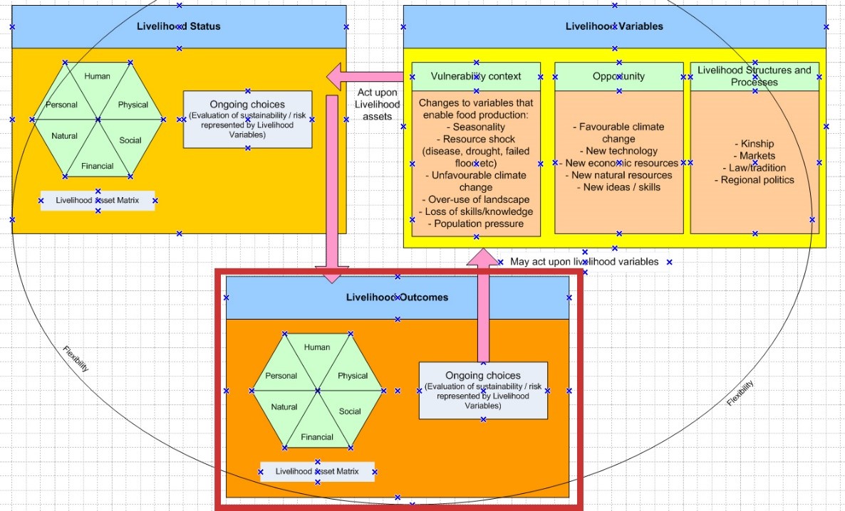 Figure 27 – Livelihood Outcomes section of the SRL Model, outlined in red
The Livelihood Outcomes represent the action of the vulnerability context on the asset matrix, resulting a new set of socioeconomic conditions (figure 22). The southward shift of the ITCZ appears to have been underway after Gilf B and before Gilf D, changing the climatic conditions for Gilf C. Excavations revealed that there are no Gilf C remains in Wadi Hamra, at the north of Gilf Kebir, although there are plenty of Gilf B remains, and Riemer suggests that this was due to the shifting of the summer rains, leaving Wadi Hamra too dry to occupy (Riemer 2012, p.345), which seems peculiar as of all the wadis, Wadi Hamra today supports the most foliage and wildlife. The groups living in the Gilf Kebir were clearly becoming increasingly dependent on the southern plateau with the dune barrier lakes. The breaching of the dune barriers, first in Wadi el-Akhdar and later in Wadi el-Bakht, caused the Gilf Kebir to be abandoned at that time, and it was not reoccupied until the Gilf D.
Although the area was not permanently abandoned by human groups after the mid-Holocene breach of the Wadi el-Bakht dune barrier, the Gilf D period from 3300-2700BC that followed it some 200-300 years later (according to dates in Gehlen et al 2002 and Linstädter and Kröpelin 2004) was far more ephemeral. The toolkit, with a high percentage of asymmetrical microliths from 80/14 and 99/51, reflect a return to a livelihood dominated by hunting (Gehlen et al 2002), although a tentative identification of cattle bones (Czsiela 1996, p.229) suggests that a small herding component may still have formed part of the livelihood mix. This suggests that there was not sufficient water to sustain herding as a livelihood strategy and that dependence on animals that were highly adapted to arid conditions were depended upon in the period following Gilf C. Hodder (1982c, p.87; 97-8) describes how it is by no means unusual for some herders and farmers to revert to hunting and gathering at times of economic stress.
There is no evidence of human/herd impact on the Gilf Kebir but it could easily be that herds exacerbated the environmental deterioration as increased variability led to fluctuating resource availability. There is a much higher risk of large domesticated herds over-grazing than wild fauna, as they share the same diet and may also be in competition with wild fauna for some plant resources, although fire can be used to drive off wild fauna (Barrow et al 2007, p.3; Lankester and Davis 2016, p.474; Ockwell and Lovett 2005). There is no indication, however, that the herds at the Gilf Kebir were sizeable enough to result in a high-risk environment. Environmental downturn does not seem to have resulted in the type of competition or consolidation of groups and resources that might be expected to lead to hierarchy, either, although it did apparently result in the growing importance of funerary traditions along the Nile and at Gebel Ramlah in the Final Neolithic (Brunton and Caton-Thompson 1928; Brunton 1937; Brunton 1948; Chaix et al 2012; Kobusiewicz et al 2010; Paris 2000; Reinold 2001, p.2-10; Schild and Wendorf 2001, p.16-17; Wengrow et al 2014). In each of the case studies I have looked in the published literature for signs of overgrazing, an important signal for which is the decline of perennials and the dominance of annuals (Campbell et al 2006, p.79), but there as in other areas there is insufficient data to comment. However, as Seely points out (1991, p.8) areas where water is available during the dry season may be highly vulnerable to over-grazing when livestock numbers are higher than the local biomass can support.
As mentioned above, some groups returned to use the Gilf Kebir after Gilf C, represented by the somewhat ephemeral remains of the Gilf D, but the lack of density of the sites compared to Gilf C suggests that others had moved elsewhere. Based on their work on Sai Island, Garcea and Hildebrand (2009) have suggested that Nile side sites may have become refuges from Saharan groups forced out of the desert areas. For the occupants of the Gilf Kebir and Jebel Uweinat it seems likely that some did indeed head south towards the Middle Nile when the Gilf Kebir was abandoned after Gilf C. There are indications that they moved towards the southwest towards the highland areas of Tibesti in Chad, where there are already indications of links in the Gilf C (Linstädter 2007), or to the west, were highland areas still attracted rainfall and could support pastoral subsistence (Hassan 2008). Hassan argues that movements of cattle can be tracked in an east to westward movement, with the movement of people taking up better watered areas in the Saharan highlands such as Tibesti, Tassili, Ennedi and Hoggar (Hassan 2008, p.52). di Lernia sees a spread of a cattle cult from the Egyptian Sahara to the central Sahara, as small groups dispersed following the climatic deterioration at the end of the mid-Holocene (2006, p.59-60). Others may have followed the rains and wild herds south, as suggested by inventories at Wadi Shaw, Wadi Sahal and the Sudanese Nile valley (Schön 1996a, p.128).
The cultural divide between the Nile and desert at this time, which had previously been fairly fluid, was becoming more pronounced as complexity along the Nubian and Sudanese Nile apparently reflects greater concentrations of people (Riemer 2007a). It might have been more natural for herders at the Gilf Kebir to envisage the maintenance of existing patterns of behaviour and core values by migrating east, than opting for new lifeways along the Nile with its entirely different cultural output and its increasing circumscription, particularly if, as in Turton’s model of the Mursi of southwest Kenya (Turton 2011, p.165), mobility was inherent in their worldview.
6.0 Answering the key questions
6.1 What drew occupants into the area and why did they remain?
The Gilf Kebir would have been highly attractive for a number of reasons. First, the rainfall regime, with winter night-time precipitation would have allowed the establishment of perennial plant life, which would have contributed to improved soil conditions and in turn encourage the establishment of greater biodiversity, on which both wild and domesticated herds could graze and browse. Sometimes summer rainfall may have fallen too, due to the area of raised land between the Gilf Kebir and Jebel Uweinat. Water, whilst low, unpredictable and seasonal, formed temporary pools on the plateau and pediplain, and playa lakes built up behind retaining dunes in wadis on the eastern edges of the Kemal el Din plateau. Trees that provided shade, fuel, manufacturing and construction materials, were found in different niches throughout the Gilf Kebir. The biogeographic bridge between Gilf and Uweinat enabled the establishment of species within the Gilf that might not otherwise have colonized the area. Lakeside species that regenerated during the rains lined the sides of the playa lakes, suitable both for forage and for craft activities. Pasture on the plateau, together with raw materials for stone tool manufacture, enabled a strategy of localized mobility to be adopted in order to maximize the value of each of the environmental and topographical features. Within a few days travel, Jebel Uweinat provided accessible resources for the dry season, as well as the opportunity to meet with other members of the extended family as well as other kinship groups, to share information and ideas. Further afield, the Gilf groups were probably making connections with other areas.
6.2 What types of risk may have been experienced?
Following Richards (2013), who divides risk into economic, symbolic and social, the main forms of risk potentially experienced were as follows:
Natural risk
The Gilf Kebir was inherently a high-risk environment. It was dependent on rainfall, and in these types of environment rainfall can vary both temporally and spatially. As the mid-Holocene proceeded precipitation would have become increasingly stochastic. Even when it arrived on time, volume would have been variable, and low levels of precipitation would have resulted in pasture but lower levels of potable water. High evaporation would have been responsible for lowering the water levels even in good years. Most of the plant resources would have been seasonal, with only a low density covering of tree and shrubs to provide shelter and fodder for goats. The dune barriers themselves, whether it was perceived or not, were not permanent, but when Wadi el-Akhdar was breached, probably by an unprecedentedly high rainfall event, the risk must has become clear. The breach of the Wadi el-Bakht dune barrier ended the Gilf C.
Economic risk
The Gilf area was only available for occupation after rainfall, when water built up behind the dune barrier and settled on the plateau and in depressions in surrounding plains. If, as seems likely, the Gilf was used to rest the Jebel Uweinat area, lower than expected rainfall could have led to poor quality pasture and shortened duration of stay. The failure of rains would have an impact on conditions at Jebel Uweinat, where local pastures would not be rested. This may have had a knock-on effect on the condition of herds and the human groups depending on them.
Social risk
Although social risk may be observed in any modern enterprise, it is often difficult to detect archaeologically. Social risks may impact both the individual and the community as a whole, in terms of negotiating status, ensuring access to resources and taking up new opportunities. There is no clear evidence of social organization at the Gilf Kebir, no pointers towards whether people actually identified themselves as communities or were loose affiliations of households sharing resources to herd livestock. However, the connection with the Jebel Uweinat and beyond suggests that inter-group relationships may have been important and centred around the well-watered Jebel, which would make the Jebel Uweinat a centre of negotiation and possibly conflict in which some households and individuals within them would fare better than others.
Symbolic risk
The risks come in two parts – the risk to the belief system of the group should its investment and its sacrifices fail to produce the desired outcomes, and the risk to any individual who was mediating between the real and the supernatural worlds. Social and probably economic risk may have been mitigated by the creation of rock art and the expression of the ideas and belief that lay behind it, together with any rituals associated with it. Although there are no indications of hierarchy, the rock art and its presence in distinctive locations might indicate the presence of a religious role, a person with specific knowledge and skills for interfacing between people and the supernatural. Any threat to social and economic stability could be a risk to the group’s beliefs, which in turn would impact on their social identity. Any individual whose role was to ensure that the deities were sufficiently motivated to take care of the interests of the group as a whole would have found their position at risk if they were unable to intercede with the supernatural on behalf of the living. Symbolic risk may have been high as failure of a belief system and the underlying sense of security that went with it could have caused an identity crisis within the group.
The next key question looks at how some of these risks may have been handled.
6.3 How were risks managed?
The checklist for risk management strategies (Chapter 5, p.71) forms the basis for a comparison of all areas. I have used a simply yes/no/? judgement on whether there is evidence for a practice, but I have also indicated how much confidence there is in the data and the judgement, using a simple High (H), Medium (M) and Low (L) scale (table 12)
| Evidence for strategy present
Yes/No
|
Quality of data available | Confidence that strategy practiced | |
| Food procurement Diversification | Yes | M | H |
| Food procurement Specialization | No | M | L |
| Storage | No | M | L |
| Mobility | Yes | H | H |
| Habitat management | Yes | M | H |
| Social networks | Yes | H | H |
| Communication of knowledge | Yes | M | H |
| Exchange of information | ? | L | M |
| Leadership / roles | ? | L | M |
| Division of labour | ? | L | H |
| Technology specialization | No | H | L |
| Ideology and religion | Yes | H | H |
| Opportunity and innovation | Yes | M | H |
| Conflict | No | L | M |
| Trade/exchange | Yes | M | H |
| Stint/hunger foods | No | L | M |
| Migration out of the area | Yes | H | H |
| Remaining to experience impoverished conditions/death | No | H | H |
Table 12 – Risk management strategies in the Gilf C
- I have suggested that diversification was practiced, based on the use of cattle, sheep and goat, hunted species and the presence of grinders. Botanical and faunal remains are poorly preserved but they are represented and they suggest a broad use of available resources.
- Specialization is not suggested in any aspect of the food procurement strategy, and it does not appear that storage was used to mitigate shortages.
- Mobility was important, and although the quality of the data for Gilf C occupations are less easy to identify beyond the Gilf/Uweinat area, it appears to have been practiced over long distances. Gilf C mobility practices changed from Gilf B, with the use of multiple landscape components for dry season herding and hunting, in both the Gilf and Uweinat areas, implying that care was taken to rest areas and use others selectively in order to avoid overgrazing and to maintain biodiversity.
- Habitat management is suggested both by the use of multiple areas within the Gilf and by the alternating use of Wadi el-Akhdar and Wadi el-Bakht, which has been suggested was due to the need to allow natural wood resources to recover (Linstädter 2002, 2007 p.23).
- Social networks are indicated by material remains from other areas and by the presence of multiple groups at Uweinat, and this impression is reinforced by the importance of social links in modern pastoral groups today.
- The communication of economic and social knowledge is clearly demonstrated by the ongoing routines, technologies and economic practices over centuries, whilst the exchange of information is implied mainly by its value to modern comparable groups who rely upon information about rainfall and pasture in order to move herds and communities with confidence.
- Whilst there is no specific information about leaders or individual roles that might have helped to mitigate risk, there is the possibility that religious activities required expertise that would have been incorporated into specific roles. Leadership and head-man roles are entirely compatible with pastoral subsistence, but the evidence is simply not there.
- Division of labour is usually essential in herding communities, so the absence of data does not prevent there being high confidence that men, women, children and the elderly all had specific role in economic, domestic and social aspects of life.
- Although there is plenty of data for stone and even ceramic technologies, none of these appear to have demonstrated much functional specialization but although technology does not appear to have been particularly specialized, the low levels of time and effort required in its production is an innovation in its own right after the more time-consuming microlithic technology of the Gilf B.
- Opportunity was taken up with the adoption of domesticated livestock when hunting was no longer a practical livelihood option, and settlement patterns were adapted to meet the needs of new environmental conditions and livelihood strategies.
- If rock art and its locations are accepted as representing religious or ideological concepts, then both the data and the confidence for numinous activities is good, although its character is unknown.
- There are no indications of physical conflict, but although I have argued that negotiation and formal arrangements could have been used to mitigate risk in this area, it would be surprising if no disagreements and disputes took place.
- Trade or exchange are likely to have taken place, and there are some indications of long distance contacts in the material remains that support this. The ability to acquire goods in return for products or services can help to minimize both economic and social risk.
- There is no evidence either for or against the practice of stint or the use of hunger foods, but towards the end of the mid-Holocene it is likely that hunger goods became increasingly important.
- At the end of the mid-Holocene emigration out of the area indicates that a pastoral livelihood was no longer viable at the Gilf and Uweinat.
As in Key Question 6.2, it is also possible to consider risk handling in more detail in the specific areas of economic, social and symbolic risk, following Richards (2013).
Economic risk
From an environmental point of view, the mixture of species has a number of advantages for the longevity of biomass, as each specie has characteristics that complement the others. Cattle require high volumes of grass and water in order to maintain their bulk, provide meat and fat, and supply dairy products, but they are highly efficient converters of plant food, particularly cellulose that cannot be digested by humans into meat and dairy, and are easily herded. Goats are much more drought tolerant and will survive well on low quality fodder and waste, which they will scavenge, but can devastate meagre resources with their ability to consume roughage. A benefit of mixing cattle with ovicaprines is therefore clearly that not all animals will suffer equally during droughts. Wild fauna, with different food preferences and the ability to survive without water, are most resilient and offer the least threat to any one type of plant resource.
Diversification was practiced in the form of mixed herds that took take advantage of different environmental niches (cattle and ovicaprids) in the hunting of wild arid-adapted species and, as implied by the presence of grinders, the exploitation of wild grasses and other plants. Livestock herds were probably relatively small, perhaps a few heads per household. This is certainly suggested by the scant bone remains although this can be deceptive (Linseele et al 2010) but a conservative stocking strategy, maintaining consistent low numbers of livestock, might be the safest approach under conditions of risk and uncertainty from a purely economic perspective (Campbell et al 2006, p.76-78, 82; Moule 1970, p.436). This runs the risk of losing too many individuals during drought periods, making restocking difficult, so if a conservative strategy would still need to ensure sufficient heads of livestock to survive an extended dry period, to allow for losses.
The need to move herds between water sources presents a higher level of uncertainty, due to the possibility of seasonal drought, but this may be balanced by the convenience of having herds to hand, as storage on the hoof and as a form of insurance against drought and hunger periods (Binns 1992; Cliggett 2005). Riemer (2007b) suggests that the desert areas were navigated along specific routes, between specific nodes, due to the change of climatic conditions and the need to move between reliable sources of water and pasture. Patterns might be clarified by expanding the survey ofthe surrounding plains and by trying, as Honoré suggests (2015), to track patterns of mobility by analysis of rock art. There is a much higher risk of large domesticated herds over-grazing than wild fauna, as they share the same diet and may also be in competition with wild fauna for some plant resources. Humans may also be in competition with animals for nutritious wild plant food (Diehl 2105, p.353). There is no indication, however, that the herds at the Gilf Kebir were sizeable enough to cause this type of risk.
The availability of pasture on the plateau as well as on the plains and wadis must have been a welcome extension of the available food produce available to herders, reducing the risks of over-grazing. Indeed, the structured exploitation of the Gilf Kebir in combination with the Jebel Uweinat and the network of base camps, smaller camps and ateliers described by Linstädter (2003a) indicate that the small scale communities at the Gilf Kebir were not merely environmental bystanders adapting passively to new conditions, but deliberately modified how they used the new conditions, developing new patterns of mobility and extending their resource base to include domesticates and make the most out of the available environmental niches within a challenging dry savannah area. They are a good example of groups today, who optimize high risk variable arid environments in order to maximize production, using multiple forms of mobility and swift responses to information in order to achieve this.
It has been suggested (Linstädter 2003a, 2007 p.23) that Wadi el-Akhdar and Wadi el-Bakht were used alternately, from year to year, possibly to allow trees to recover. Wood from trees and shrubs can be used for fuel and tool manufacture, and new shoots and roots can be used to supplement feed (Moule 1970, p.439), and due to its value in dry savannah contexts needs to be carefully curated (Hobbs 1989; Manger et al 1996).
The decoration on the pottery sherds indicates affinity to a wider area of cultural output, perhaps representing an allegiance to other people who may have been part of different kinship networks and culturally very different, but with whom connections were important. These may have had beneficial economic consequences in terms of trade and information exchange, and are likely to have mitigated social risk as well.
Social risk
There are no indicators of social risk, which lies in concepts like leadership, status and individual roles. When climatic deterioration started to have a noticeable impact on land use potential, established arrangements for herd management and rights to resources may have become strained, putting pressures on kinship networks and inter-group relationships. It is highly probably that relationships with other groups that initially reinforced social stability began to break down. At the end of the Gilf C, the breakdown of traditional arrangements and the convergence of diverse groups on certain refugia may have required renegotiation or new negotiation over rights of access to land and water sources, and traditional units of decision making may have been challenged as household made what they considered to be the best arrangements for their own families. Abandonment at household level would have led to fragmentation not only of close-knit groups but also of regional identities, leading to people having to re-invent themselves and re-build individual and cultural identities. Whilst there are no signs of conflict, it is very likely that land sharing arrangements were first formalized in order to regulate usage of valuable resources and to minimize conflict but even these arrangements will have been put at risk as environmental change forced people to converge on reliable resources, perhaps staying in dry pasture resources on a year-round basis, over-exploiting small areas of refuge and forcing the renegotiation of relationships, and the abandonment of some areas.
Symbolic risk
Symbolic risk, the possibility that deities, spirits, ancestors or other numinous forces might fail, must have been very real in the Gilf area, even with the fairly Uweinat close to hand, particularly as the desert dried and people were forced to make decisions about how to handle increasingly stochastic rainfall and declining resources. To what extent the rock art represents an interface into another realm is completely opaque, and it would be quite wrong to assume that it did, and there is little else to help determine if the rock art was a part of a wider range of ideas concerning how to maintain control over the environment. Under severe conditions of environmental deterioration ordinary livelihood arrangements would begin to break down, and this carried the risk of undermining not only the subsistence base of groups, but the entire belief system that supported them.
The conclusion is that risk management was based on diversification combined with high residential mobility. Intelligent use of the landscape based on knowledge and experience, enabled sustainable use of the habitat. There are no indicators of leadership, but the application of rock art in secluded areas suggests that expertise in numinous matters may have been leveraged to minimize ideological and religious risk.
6.4 How can the livelihood be characterized in subsistence terms?
The subsistence economy of the Gilf Kebir was based on livestock herding supplemented by hunting. Plant collection would also have been practiced. It is most probable that Gilf C groups were characterized by a high degree of logistical mobility between a number of local and more distant zones throughout the Western Desert. The plateau was used extensively, and small sites were found on the playa surface. None of the sites are large, and it seems that they either represent single extended households or small numbers of households, with some resource exploitation sites representing sometimes just one person. The Gilf Kebir occupations seem to be an offshoot of Jebel Uweinat. At the moment the main data to suggest this is rock art, and further survey and excavation needs to be carried out in the Jebel Uweinat area to clarify how different massifs and hills were used in conjunction with each other and with the plains surrounding them. However, it is possible that the main residential base was at Jebel Uweinat when groups were in the area, reflected in the high number of rock art panels, with individual households or herding parties occupying the Gilf Kebir during the wet season. A non-specialized tool industry and hand-made pottery were not demanding in terms of knowledge transfer or labour, but combining herding, hunting and plant collection activities would have required organized division of labour, probably making the best possible use of children, adults and the elderly to ensure that all roles were carried out seamlessly, either based at Jebel Uweinat or moved seasonality to the Gilf Kebir. There are some indications of exchange, but the nature of the exchanges is not at all clear and it is not possible to state, for example, whether exchanges actually contributed to subsistence or were optional luxuries.
6.5 Has it been possible to identify where decisions have been made and what they were?
Although the entire social and economic profile of the Gilf Kebir represents ongoing decisions at multiple scales, it is difficult to pick out individual decisions made within the Gilf Kebir assemblages, there are four areas that can be isolated for discussion.
The first is the decision to adopt and manage domesticates, and has been discussed above in section 4.2 Opportunity. From then on, risk was a constant process of problem solving and decision making (Segal 1994, p.25-26).
A second is the expansion of well-defined campsites onto the plateau in Gilf C, when it had not been used in Gilf B, demonstrates the enterprise of herders to extend into new territory when it becomes available. Rock art, as part of a cultural structure for reinforcing traditions, becomes part of this transmission of knowledge. Some campsites are directly related to raw resource acquisition. Quartzite was the dominant form of stone employed during Gilf C and the plateau was a good source of it, with campsites appearing alongside workshops (Linstädter 2003; Claßen and Pastoors 2005).
Raw material acquisition sites that seem to represent the activities of one individual at a time. These small and short-term sites may be connected with decisions at a family or household level for an individual to move to quartzite outcrops, with or without livestock, to source stone and manufacture preforms before moving on. Decisions of this sort may have been made on an ad hoc basis as new tools were required for household and subsistence uses.
A third example comes from the paintings of a cows with distinctive markings, in relationship with one another and with people, usually in secluded and often hidden places. These were not casually executed. They were skilfully composed and executed, bringing personal knowledge and wider experience of the livelihood into a conception that was of importance either to the individual or to the people who would visit the site. Whether it was executed as a rite to achieve a specific event or was an act to sanctify a place, it represents a definite statement and the decision to make that statement represents a decision about what needed to be achieved, where that statement was to be located and how best to go about fulfilling the requirement.
A final set of decisions were those made in order to abandon Gilf. There is insufficient resolution in the data to detect whether departure was piecemeal, with a few households choosing not to return whilst others persevered, or whether the entire community departed when the Wadi el-Bakht dune barrier was breached. But it is clear that these decisions at household and group level eventually resulted in the abandonment of Gilf Kebir by livestock herders. The Gilf was not apparently reoccupied for 200-300 years, and then the subsistence strategy was based on hunting.
Contacts with other areas have been discussed throughout the case study, and amongst the groups who inhabited the Gilf Kebir there may have been the need to make decision on an ongoing basis not merely in terms of how to cope with livelihoods in marginal environments but how to manage encounters with different groups and their herds in shared territories, adapting their knowledge as needed in a very dynamic world.
6.6 How has group identity manifested itself in the archaeological record?
Identity is at all times fluid, along a continuum of highly individual identity to the definition of a family or entire community, and may include ideas about age, gender, spiritual life and specific roles within society. Unfortunately there is insufficient data to explore these ideas but a number of observations may be made, based on the idea that the repetition of style and design in a given area is suggestive of a collective approach to translate traditional ideas and values into visual representation. At Gilf Kebir the two forms of material output that best represent an identifiable tradition of stylistic output are the ceramics with the emphasis on distinctive herringbone decoration and the Cattle Herder style rock art. Both conform to a visual code that would be fundamentally familiar to both makers and users, and probably to many outsiders too.
The herringbone pattern on pottery, which has no exact parallels outside the Gilf Kebir until towards the end of Gilf C may speak to a strong sense of kin-based or community identity, perhaps in response to a multi-ethnic presence at nearby Jebel Uweinat.
The rock art, which appears mainly at Jebel Uweinat but also finds expression in the rock shelters of the eastern Abu Ras plateau, again conforms to an instantly identifiable execution that can be classified by repeated style and features. This repetition was an important part of why each image and composition was painted and how it was used. Whether it was intended as a message to those within certain recognizable groups, or as a way of identifying those groupings to the external world is not known, but the skill and dedication invested implies that both those involved with the rock art and its ideas understood it in the context of their own social identity.
Representations of humans on rock art of the Cattle Herder period suggest that body painting was practiced, which may have been used to differentiate individuals, ages, roles, households within kinship groups, or entire communities. Details of clothing, accessories and arrows are not detailed enough to indicate differentiated aspects like fabrics or arrow flights, but further research might shed some light on these aspects. Beads, like body painting, suggests that a certain amount of investment was made in appearances, whether all through the year or at special times.
There is no component that individually suggests that statements of identity are being made, but collectively the stylistic devices clearly indicate that the Gilf occupants had a sense of their own social coherence and were sufficiently invested in it to incorporate identifiers in their material culture.
6.7 Were opportunities taken up in times of stability or insecurity?
Hassan (2002a, p.3) and di Lernia (2006, p.132) and both suggest that aridifcation was the source of increasing complexity in the material expression of ideas, new technologies and economic systems to enable existing resources to be used more successfully. An opposing view is that well-being was the primary inspiration for innovations taking place in humid periods (Wendorf and Schild 2003, p.132).
Small livestock may have been experimented with in Gilf B2, if identification of goat depictions in rock art and goat droppings at Wadi Sura II are correct. This was at between 5500 and 5300BC when the monsoonal weather was in the process of being replaced by a temperate climate regime. The importance of domesticates clearly rose during Gilf C. In this case, deteriorating conditions seem to have spurred the adoption of domesticated livestock and associated with this were functional changes in how mobility was organized, the types of relationships people had with animals and food itself and the new types of technology they employed to facilitate the new livelihood strategies. However, domesticates were apparently adopted on a very small scale, perhaps on an experimental basis in Gilf B2, at a time when there was sufficient stability in the subsistence system to permit the occupants of Gilf Kebir to continue to exploit the wadis and their dune lakes. The increasing complexity of the Gilf settlement patterns during Gilf C and the new types of rock art and ceramics, are indicative of changes not merely in subsistence but identity. The suggestion here is that although domesticates were adopted during a time when subsistence was sustainable but environmental conditions were gradually metamorphosing, it was insecurity that was the driver, and had to be responded to with both economic and cultural transformations in order to secure the future.
6.8 Can the livelihood be characterized as sustainable?
Thanks to the transition to livestock herding and new patterns of mobility, Gilf C subsistence and cultural traditions appear to have been sustained for over 1000 years. There was doubtless immense fluctuation in both environmental patterns and the ability of the Gilf to be employed on a seasonal basis, and there may have been conflicts over land and resources, but none of this is visible in the archaeological record. What is visible is a cultural output and a system of livelihood management that remain until breaching of the final dune lake barrier, without further innovation, and this seems to be an indication that the livelihood system was sustainable, but only for the duration of the dune barriers. The livelihood strategy was apparently dependent on both plateau and wadi environments in tandem, and could not survive the loss of the last wadi playa.
6.9 Why was the area abandoned / why did the type of occupation change?
The switch from tolerable to intolerable conditions in the area as a whole is unlikely to have been sudden, but deterioration would have led to increasingly unpredictability with drought tolerant species increasingly dominant and greater difficulty of environment to recover from droughts and any over-grazing. However, the breaching of the dune barrier during a period of environmental deterioration eliminated the Gilf Kebir as a viable part of the seasonal round. Without the dune lakes, the Gilf C livelihoods would have been tipped from a status of risk to one of uncertainty. As observed in section 4.3 (External Livelihood Structures and Processes) no obvious other factors are obvious potential contributors to account for the departure of groups from the Gilf Kebir, if the inhabitants were wished to sustain a herding livelihood. Even if they had discussed a switch to a hunting strategy, it is very unlikely that sufficient food and water were present to sustain more than a few people.
The following schematic (figure 23) shows the potential scenario faced by Gilf C people at the end of the mid-Holocene, with the twin effects of desiccation and the breached barrier dunes leading to a number of potential scenarios which could have raised risk to the point of uncertainty, forcing certain difficult choices to be made.
 Figure 28 – Proposed decision process for migrating away from the Gilf Kebir
7.0 Gaps in the data and future research
More survey and research work, particularly looking at linkages between areas and the acquisition of more radiocarbon dates, should help to clarify the nature of the occupation and identify any periods of stress and abandonment throughout the otherwise successful use of the area.
As observed above and in the other case studies, the functionality of tools is poorly understood so it would be very useful to initiate a comparison of lithics with studies in other regions and countries. In the Levant microwear analysis has been used to indicate variations in tool motions and contact materials and these are considerable, suggesting that there is an enormous amount of variability of function and use of tools concentrated on specific parts of a tool (Shea 2013, p.309). There is no comparable microwear analysis database currently available for eastern Saharan contexts (Shirai 2015, pers comm). Similarly, there is no geological database available for the sourcing of materials used in the manufacture of stone objects in the eastern Sahara, and this inhibits analysis of the acquisition of stone as part of the overall chaîne opératoire.
Seasonal occupation might be tightened up with phytolith and diatom analysis of dune playa beds and the isotopic data from animal remains.
Rosen et al (2008) note that Bagnold’s Circle, a stone circle found by Bagnold in 1930 450km west of Nabta, ought to be excavated in order to judge whether or not it was related to Nabta. It is twice the size of the Nabta circle but made with similar sized stones and so far appears to be undisturbed. Similarly the tumuli, monoliths, standing stones in Wadi Abd el Malik and those standing stones on the plateau above (Peroschi and Cambieri 2010) have not been excavated, but long bones protruding from one of the tumuli suggest a burial function, and further investigation would be desirable.
In completing the model, the lack of sufficient data about links between areas has stood out. Although some artefact types seem to have affinities with those in other areas, in order to understand the type of annual routes travelled by Gilf B and Gilf C groups, and to clarify which other groups made up part of their larger kinship groups and which they may have had some less intimate contact with, far more research needs to be undertaken.
The relationship between Jebel Uweinat and Gilf Kebir needs to be clarified by further investigation in both areas, but particularly in the Jebel Uweinat. The intervening and surrounding geological structures and the plains beyond also need to be understood in more detail. Due to the distance of the Gilf-Uweinat area from the Nile to the east or Kufra to the west, expeditions are complicated and are necessarily constrained in terms of both time and resources. Within the Gilf Kebir, research is currently focused mainly on the Gilf B sites in the Wadi Sura area. Research into comparable Gilf C sites will also be of value in the future. Full investigation of the Gilf-Uweinat area will probably take decades.
Because all of the identified sites are palimpsests, it is not yet possible to identify contemporaneous small-scale activities but refitting may be a tool to assist with this line of inquiry in the future (e.g. Close 1996; Close 2002a; Vaquero and Pasto 2001; von Czierniewicz 2004). Furthermore, an agreed upon archaeological methodology for handling palimpsests globally would be of considerable use, so that results can be understood with confidence. It is impossible to avoid palimpsests in any dryland context, so having an agreed upon series of standards for survey, excavation and interpretation would be of great value.
It would be useful to compare Gilf B and C using the SRL model to gain a better understanding of the continuities and differences between the two periods.
8.0 Conclusions – the value of the SRL model in this area
A principal value of the SRL model in the discussion of the Gilf C period is again the demonstration of the type and scope of questions that can and should be asked about prehistoric settlements and all the associated complexities that go with them. As with the other case studies, it has been demonstrated that a number of approaches can help to elucidate different aspects of the archaeological record. The use of the Asset Matrix ensures that all aspects of the archaeology have been treated equally, enabling an in depth and livelihood-centric understanding of the Gilf C and its relationships with other areas. Although the data is fragmentary and lacks chronological granularity, it has been possible to present the Gilf C as a flexible and productive entity engaged in successful subsistence strategies and using cultural output to reinforce identity and manage frontier situations.
Households in the Gilf C successfully managed environmental, social and symbolic risks in environmental conditions that were shifting towards increasing aridification, and this has been demonstrated very clearly by bringing the understanding provided by archaeological approaches of the last few decades, understanding of the management of sustainable livelihoods by those engaged in development and anthropological projects to bridge assist with understanding the published archaeological data. The rigid discipline imposed by the Asset Matrix is used in conjunction with the explanatory components to assist with interpretation of the descriptive data.
