
Before reading this case study
Before reading this case study, it is strongly recommended that you read Chapters 1 (introduction, which introduces the SRL approach and discusses how the ethnographic data is used in the case studies), 2 (detailed explanation of the modelling approach), 5 (ethnographic research that informed the case studies), the relevant bits of 6 (background information to the case studies, including excavation history and notes about chronology), and 7 (the SRL template) all of which are essential to an understanding of how the case studies were compiled and what they are designed to achieve. The case studies were never designed to be read as stand-alone pieces. Chapter 9 compares the case studies, and may be of interest to those who are interested in different approaches to livelihood management in dryland areas.
As explained within the thesis, my priority was to test the Sustainable Rural Livelihood model, which was derived from development economics. This means that the emphasis was on pushing the data to the absolute limit. This has resulted in speculative scenarios that match the data, many of which are by no means the only possible explanations and are open to challenge. I believe, however, that some speculation is a healthy move towards the creation of hypotheses that can be tested rather more empirically, and hope that the speculative relationship between the published data and my speculative extrapolations is made explicit.
You can read and print the case study from this page, but you can also download it as a PDF here.
1.0 Introduction
The following section discusses the Bashendi B period of Dakhleh Oasis, within the framework of the Sustainable Rural Livelihood approach and is divided into the sections described in chapter 7. The Bashendi B dates from c.5300-4000BC. As described in the introduction to the case studies, Dakhleh Oasis is located in the Western Desert at 25˚48’N/29˚05’E, one of a crescent of four very large oases that run from south to north. It is 600kms south of Cairo, 250km from the Nile to the east and its overall area is 2000km2, extending some 70-80kms east to west and 20-25kms north to south (Torab 2013). The lowest point is 100m above sea level (Vivian 2008, p.179).
The objectives of the case studies have been outlined in chapter 6, but the primary aim of the Dakhleh case study is to use published data to consider livelihood strategies in the potentially constrained circumstances of an oasis.
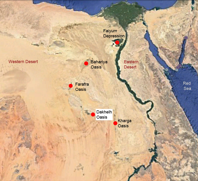 Figure 1 – Dakhleh Oasis in the Western Desert, together with
the other oases mentioned in the text, and the Faiyum Depression
(Source: Google Earth)
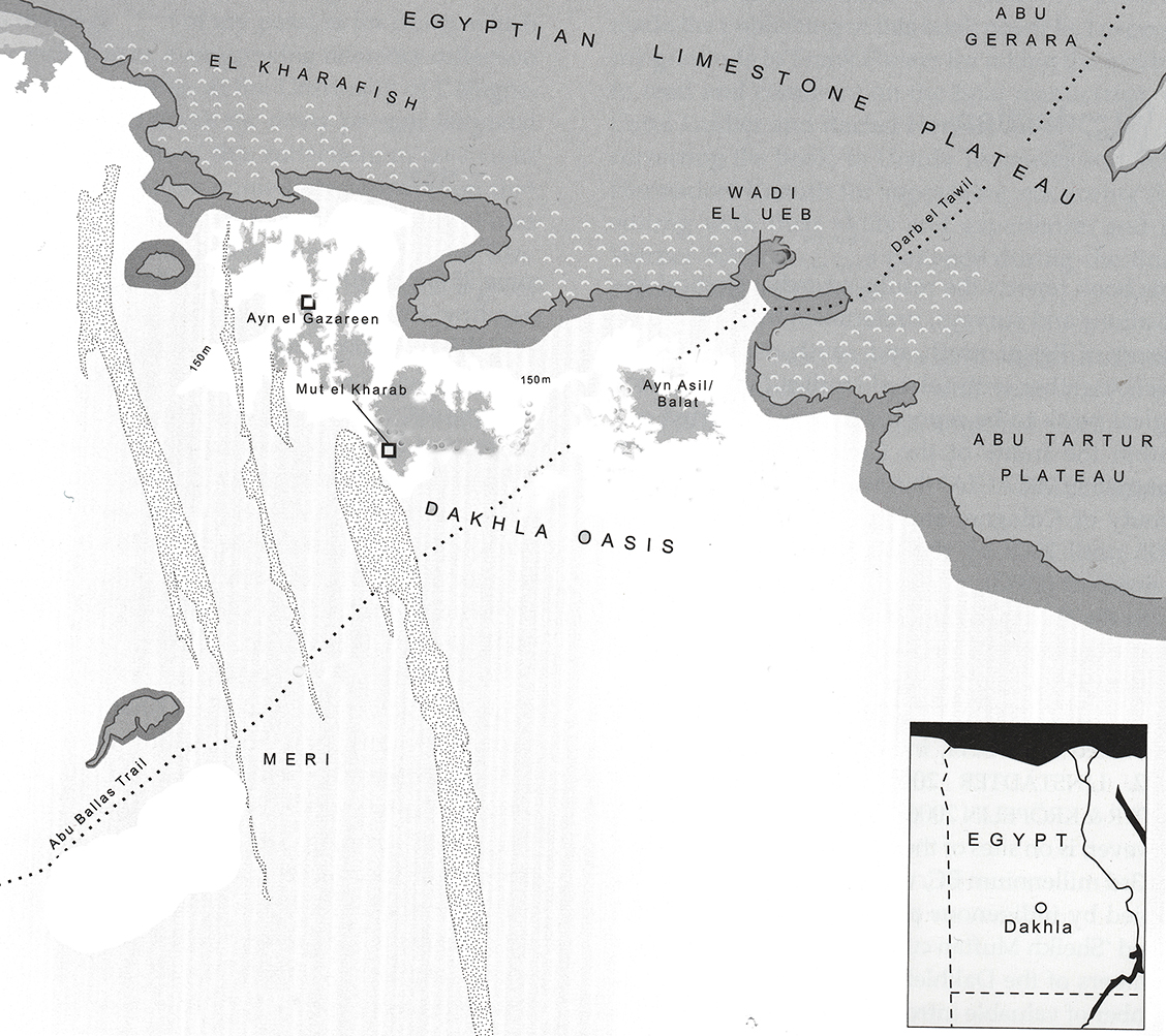 Figure 2 – Map of Dakhleh Oasis showing the Limestone
Plateau (Source: Riemer 2011, p.18)
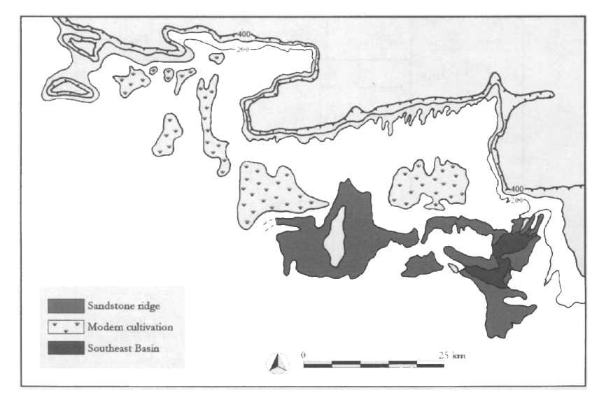 Figure 2 – Schematic map of Dakhleh showing the Southeast Basin,
where most Bashendi B sites are located. (Source: Wharfe 2003a, p. 180, fig.3)
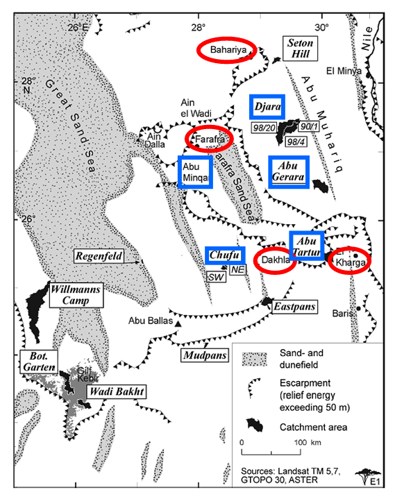 Figure 3 – Areas mentioned in the text. Oases outlined in red. Site clusters
outlined in blue (Source: modified from Bubenzer and Riemer 2007, p.608, figure 1)
2.0 The data available for each phase
The published data types available are summarized in Table 1.0, below, and variations in quality of that data will be discussed throughout the text.
Yes=Present / No=Not Present
| Category | Data | Yes / no |
| Site type | Settlement | Yes |
| Cemetery (concentration of multiple burials) | No | |
| Ceremonial (monuments and ritual structures) | No | |
| Unknown | – | |
| Architecture | Domestic shelters / foundations | Yes |
| Hearths / Steinplätze | Yes | |
| Storage | No | |
| Ceremonial structures | No | |
| Type | Stratified | No |
| Palimpsest / Chronologically undetermined | Yes | |
| Cave / rock shelter | No | |
| Funerary | Burial structures | No |
| Human physical remains | No | |
| Grave goods | No | |
| Diet | Faunal remains | Few |
| Botanical remains | Few | |
| Environment | Faunal remains | Few |
| Botanical remains | Few | |
| Sedimentary and geomorphological data | Yes | |
| Other environmental / climatic indicators | Yes | |
| Tools/ Craft items | Stone tools | Yes |
| Grinding stones | Yes | |
| Pottery | Yes | |
| Ostrich eggshell | Few | |
| Basketry, cordage etc. | No | |
| Animal products | No | |
| Other artefact types | No | |
| Personal or symbolic material | Beads / other jewellery | Yes |
| Portable art | No | |
| Palettes | Yes | |
| Cultural components on everyday tools / pottery | Yes | |
| Rock art | Yes* | |
| Prestige objects (potentially) | Yes | |
| Dating | Radiocarbon dates | Yes |
| Relative / stylistic | Yes |
Table 1 – Bashendi B data available for Dakhleh Oasis. * Although rock art is present in Dakhleh it cannot be tied into the chronology of the oasis so is not used here.
| Site“Locality” | Type of site | Key features |
| #74 | Occupation | Notable for a small collection of uncoated sherds with incised triangular motifs and impressed dots; other examples display rim notching/incising |
| #77 | Occupation | Hearth mound downslope of edge of SE Basin at “Central Lowlands” – a site associated with a large basin |
| #101 | Occupation | Hearth mound downslope of edge of SE Basin at “Central Lowlands” site associated with tabular sand sheets |
| #104 | Occupation | Hearth mound downslope of edge of SE Basin at “Central Lowlands” site associated with tabular sand sheets |
| #106 | Occupation | Hearth mound downslope of edge of SE Basin at “Central Lowlands” site associated with tabular sand sheets |
| #165 | Occupation | Hearth mound downslope of edge of SE Basin at “Central Lowlands” – a site associated with a large basin |
| #271 | Occupation | Densely clustered hearth mound with goat and cattle remains in pits |
| #276 | Occupation | Densely clustered hearth mound |
| #385 | Occupation | Area with c.150 features including hearth mounds, artefact clusters and faunal remains, typical of most Bashendi B sites. Southeast Basin |
| #385 Artefact scatters | Occupation | Tools and cores and other items common to the Bashendi B. Southeast Basin |
| #385 Feature 32 | Occupation | Mound with a few sandstone fragments over a thin layer of charcoal. |
| #385A Feature 29 | Occupation | Anomalous stone built structures, probably huts for special use, of which only one of seven has been excavated/published. Southeast Basin |
| #385A Feature 30 | Occupation | Small oval feature with flat slabs surrounded by verticals containing artefacts (lithics, groundstone, shells, flecks charcoal). Southeast Basin |
| #385A Feature 31 | Occupation | Small oval feature with flat slabs surrounded by verticals containing same range of items as Feature 30, also with animal bone fragments, ochre staining and a mortar beside it. Southeast Basin |
| #385A-O5a | Fire pit | Locality 385 fire pit filled with charcoal and rock. Southeast Basin |
| #385B Feature 18 | Occupation | Rock and artefact cluster. Southeast Basin |
| #385B Feature 19 | Function unclear | Double mound capped by layers of sandstone slab. Southeast Basin |
| #385B Feature 20 | Occupation | Rock and artefact cluster. Southeast Basin |
Table 2 – Bashendi B sites mentioned in the text
| Site/Feature | Uncalibrated c-14 dates bp
|
Calibrated dates BC | Lab. No. |
| #270 | 6470±70 | 5431±60 | Gd-5722 |
| #276 | 6370±70 | 5363±77 | Gd 5992 |
| #271 | 6360±120 | 5315±132 | Gd 6538 |
| #254 | 6300±110 | 5250±139 | Gd 6168 |
| #254 | 5940±70 | 4832±85 | Gd 5983 |
| #271 | 6280±100 | 5229±127 | Gd 6534 |
| #252 | 5930±60 | 4819±75 | Gd 6545 |
| #254 | 5830±70 | 4687±87 | Gd 5646 |
| #6 | 5800±60 | 4650±72 | B 6873 |
| #252 | 6120±250 | 5029±277 | Gd 4495 |
| #276 | 5750±50 | 4608±64 | Gd 5982 |
| #104 | 5745±80 | 4599±90 | S 2149 |
| #254 | 5630±50 | 4458±59 | Gd 5985 |
| #210 | 5530±120 | 4377±123 | B 23688 |
| #271 | 5810±50 | 4661±62 | Gd 5994 |
| #228 | 5770±150 | 4642±164 | Gd 4624 |
| #101 | 5310±160 | 4140±165 | B 17019 |
| #181 | 5610±180 | 4473±196 | B 23958 |
| #116 | 5170±90 | 3987±140 | B 17020 |
| #212 | 5130±120 | 3947±150 | B 23697 |
| #254 | 5240±110 | 4097±126 | Gd 5993 |
| #254 | 5180±110 | 4003±158 | Gd 6529 |
| #277 | 4380±120 | 3094±176 | Gd 6335 |
Table 3- Bashendi B Radiocarbon Dates. quickcal2007 ver.1.5 (Cologne Radiocarbon Calibration and Paleoclimate Research Package (University of Cologne http://www.calpal-online.de/index.html) All on charcoal or ostrich eggshell (the latter adjusted for isotopic fractionation). McDonald 1999, 2001
3.0 The Livelihood Status
3.1 Asset Matrix
3.1.1 Natural Assets
The following table summarizes the main types of zone available for exploitation during the Bashendi B:
| Zone 1 | Sahel type / savannahh conditions | In a largely featureless landscape, light seasonal rains produce a savannahh and scrub type ecology similar to the modern day Sahel, with grassland and shrubs suitable for seasonal but not necessarily year-round herding |
| Zone 2 | Highlands, low hills, high escarpments, Plateaus | Seasonal vegetation, attracting certain vegetation and game, sometimes offering different topologies and ecological niches |
| Zone 3 | Riverine | Permanent water source with floodplains, attracting vegetation, game and containing aquatic resources |
| Zone 4 | Lake / Playa / spring | With the potential for aquatic plants but not fish or other aquatic zoological species |
| Zone 5 | Groundwater zone
|
Runs along the edge of water-filled basins and supports seasonal vegetation, attracting game on a temporary or permanent basis |
Table 4 – Different landscape features in the Dakhleh area
Topography
The Western Desert within which Dakhleh Oasis is located is hyper-arid today. It is located 350km west of Qena Bend on the Nile. The oasis extends for nearly 100km from east to west and extends for only 20km from north to south. The land lies at between 100m and 135m above sea level (asl) (McDonald 2002; Ibrahim and Ibrahim 2003; Polkowski et al 2015a). It is c.140km km from Kharga Oasis to the southeast, to which it is linked by a limestone plateau.
Geologically, the oasis is dominated by 400 metre high limestone-capped Libyan Plateau to the north, which overlooks a flat clay plain to the south with lake sediments and both active and fossil springs (Torab 2013, p.2). The northern rim of Dakhleh is a cuesta, with erosion-resistant Paleocene hard limestone layers above softer Cretaceous shale and sandstone. It sits at the boundary between Nubian sandstone in the south and Cretaceous shale and Paleocene chalk in the north (Sampsell 2003, p.138, p.153). Scarp and piedmont consist of shales and limestones superimposed by gravels, sand sheets and dunes and are scarred by occasional wadis (Torab 2013, p.2). The floor of the depression is formed of Nubian sandstone (Sampsell 2003, p.153). It extends into Kharga to the east, which is not a separate geological entity from Dakhleh, hut unlike Dakhleh, which lies on an east-west axis runs on a north-south axis (Sampsell 2003, p.153).
Geomorphologically, the oases sit in depressions thought to have been formed by a combination of ancient river systems and aeolian activity during the Tertiary period (Issawi and McCauley 1992), meaning that Dakhleh now lies closer to the underlying Nubian Aquifer than surrounding desert areas. In the past, higher levels of rainfall meant that the water table was higher than it is today, and the remains of fossil springs (spring mounds) associated with prehistoric artefacts indicate that the oasis was watered over a much greater area in the past (Torab 2013, p.2). Dakhleh oasis contains two main basins, the eastern and western. The western basin is lower, at 92-121m asl, with remains of an ancient lake still visible (Torab 2013, p.2). To the west of Dakhleh are the easternmost reaches of the giant dune field, the Great Sand Sea, which consists of dunes forming north-south walls and dune corridors, creating a barrier between the oases and the Libyan border (Sampsell 2003, p.139, figure 13.1).
Hydrology
Following the end of the early Holocene, conditions in southern Egypt deteriorated (Nicoll 2004, p.569) and many settlements in today’s desert were abandoned at this time. Riemer et al discuss two periods of aridification resulting in two human influxes into Dakhleh: one at around 5300BC and another in the first half of the 5th Millennium (Riemer et al 2013). The oases had permanent water sources available, and this enables Dakhleh to be occupied on permanent basis today even with rainfall of 0.7mm per annum (Torab 2013). The aquifer water comes to the surface in the form of a series of natural springs and man-made wells, tapping into the underlying Nubian Aquifer, a vast underground reservoir of fossil waters overlying the Basement Complex and extending beneath the eastern Sahara in Egypt, the Sudan, Chad and Libya (Sampsell 2003). Summer monsoonal rainfall was also present, and it has been hypothesized that winter rainfall also reached Dakhleh providing a bimodal regime during the mid-Holocene (Haynes 1987, 2001; Kindermann et al 2006; Magaritz and Goodfriend 1985; McDonald 2016; Neumann 1989a, 1989b, 1993; Shirai 2010). Combined, these all make Dakhleh a very favourable area, attracting vegetation and wild animal species. The oasis was occupied continuously for over 10,000 years (Polkowski 2015a, p.43) and with the use of wells, sufficient water was available to support a successful Old Kingdom community and the oasis was heavily developed for irrigation agriculture during the Roman occupation of Egypt (Thurston 2003). It is still supports extensive irrigation agricultural development today (Ibrahim and Ibrahim 2003).
Dates for Dakhleh suggest that during the 6th millennium BC it was never deserted (McDonald 2001, p.35). Kharga in the south had sufficiently close links with Dakhleh for it to be proposed that they might form a single unit (McDonald 2006, p.4) and as well as benefiting from artesian water and springs from local aquifers, as well as some irregular rainfall, Kharga may have benefited from Nile overflow to create small lakes on rare occasions (Bunbury and Ikram 2014). Bunbury and Ikram suggest that a link between Wadi Toshka and the Kharga basin may have been active during the 6th millennium BC creating lakes that began to dry at around 5000BC (2014, p.11).
Light and temperature
Egypt has high a light and temperature quotient throughout the year. The lowest mean annual temperature Dakhleh is 3.5°C in January, the highest 38.9°C in June (N.O.A.A n.d.). Night time temperatures are lower, but not to the point of being detrimental to livelihood options.
Aeolian conditions
The prevailing winds in Egypt are north-eastern trade winds, which are interrupted in winter by west north-western winds from the Atlantic. In spring and early summer the hot dry dust storms called khmaseen are common (Ibrahim and Ibrahim 2003, p.52), and sweep across the plains of the southern Western Desert, visibly picking up, shifting and redepositing loose surface particles. At Dakhleh the 200km scarp helps to break up the winds, providing some protection for the basin (Vivian 2008, p.179).
Edaphic Conditions
Although Ibrahim and Ibrahim (2003, p.53) characterize Egyptian soils as aridisols and entisols, the permanent water sources, bimodal seasonality and the resulting presence of herbaceous, shrub and tree life in Dakhleh will have provided some topsoil that would have supported better biodiversity than the surrounding area. Dung deposits of both wild and domesticated livestock may have contributed to soil fertility. Early and mid-Holocene surfaces have been heavily deflated since the drying of the Sahara (Brookes 1993, p.549), but remains of sedimention surrounding the sandstone basin floors remain (Brookes 1993, p.547).
Vegetation
Wood today has been heavily depleted due to its use as firewood, but there are 67 identified species together with a limited range of arid-adapted vegetation which gather in areas where groundwater is available (Ritchie 1999). As rainfall rarely exceeds 0.7mm per annum, this vegetation is supported almost entirely by groundwater from the underlying Nubian aquifer and modern irrigation. With a mid-Holocene bimodal rainfall regime, vegetation was rich during the Bashendi B, and the presence of cattle and goat indicate that sufficient biodiversity was available to support herds sustainably. Unfortunately the data from the Bashendi B excavations, shown in table 5, is very sparse, and does no more than confirm that this area of the Western Desert was an arid or semi-arid environment.
| Botanical Species
|
|
| Data
|
Reference |
| Grasses (Paniceae – 4 macro-remains; rachis fragments; Poaceae grasses – 39 macro-remains) | Thanheiser 2011 p.84-87, tables 1, 2 and 3 |
| Sedges (Cyperaceae – 60 macro-remains) | |
| Tamarisk trees (Tamarix sp. – 73 macro-remains, 54 charcoal fragments; Tamarix aphylla ; 4 macro-remains) | |
Table 5 – Evidence for plant species available in Dakhleh Oasis.
Data derived from Thanheiser (2011, p.84-87, tables 1, 2 and 3)
The availability of standing water and possible marshes is confirmed by the presence of Cyperaceae. Cypereceae are sedges and produce fruits, seeds, green parts, tubers and rhizomes, all of which can be consumed. Tamarisk as the sole representative of arboreal species (Thanheiser 2011) is an indicator of aridity and salinity, whilst Tamarix aphylla, the largest of the tamarisks is a tall saline-tolerant evergreen that grows along watercourses in arid areas (CABI 2008). Grasses include Poaceae and Paniceae, a subclass of Poaceae (Thanheiser 2011). Paniceae are drought tolerant, and many species are highly tolerant of grazing although in the case of the perennial Panicum turgidum over-grazing can threaten soil stability as its root system forms a loose mesh of stolons Harlan 1989, p.71). Livestock grazing patterns in a constricted area of mobility can be expected to have altered the natural habitat in favour of a dominance of annual species but there is insufficient botanical data to assess this.
Fauna
The faunal remains from the Bashendi B shown in table 6 are only slightly more informative than the botanical remains. The availability of water is indicated by herding activities and the presence of hartebeest and freshwater snail, but at the same time arid-adapted species like ostrich and Dorcas gazelle are indicative of the conditions around the oasis. A surprise is the absence of Lepus capensis, the desert hare that is ubiquitous in most Western Desert settlement sites in the early and mid-Holocene, and was present in the Bashendi A, as well as in the contemporary Nabta Playa Ru’at el-Baqar, where it makes up 41.1% of the wild assemblage (Gautier 2001, p.632, Table 23.6). The species of fox and hyaena are adapted to arid to semi-arid savannah conditions (ARKive n.d.) but without being able to be certain which types of hyaena or fox is present it is not possible to be more specific, as each has very specific preferences. The wildcat Felis silvestris is a savannah breed, only occasionally found in absolute desert conditions and then sparsely, but is otherwise a highly adaptable specie. It is also found at Nabta Playa in the Middle Neolithic (Gautier 2001, p.610 table 23.1, p.620). None of these three species are found in the other case study assemblages and are non-migratory, suggesting that conditions at Dakhleh were particular attractive to species that are based in a specific region throughout the year.
| Faunal Species
|
|
| Data | Reference |
| Cattle (Bos primigenius / taurus) | McDonald 1991b, 2001 |
| Goat (Capra hircus) | McDonald 2001 |
| Ostrich (Struthio camelus) | Churcher et al 2009, p.4, Table 1; McDonald 2002a |
| Dorcas gazelle (Gazella Dorcas) | Churcher et al 2008, p.4, Table 1; McDonald 2001 |
| Red or Rüppell’s fox (Vulpes v. aegyptiaca / v. rueppelli) | Churcher et al 2008, p.4, Table 1 |
| Hartebeest (Alcelaphus bucelaphus) | Churcher et al 2008, p.4, Table 1; McDonald 2001 |
| Striped or spotted hyaena (Hyaena hyaena or Crocuta crocuta) | Churcher et al 2008, p.4, Table 1; |
| Hydrobia cf. musaensis (small stream snail) | Churcher et al 2008, p.4, Table 1 |
| Lymnaea cf. truncatula (still water snail) | Churcher et al 2008, p.4, Table 1 |
| African wildcat (Felis silvestris lybica) | Churcher et al 2008, p.4, Table 1 |
Table 6 – Evidence for animal species available in the Bashendi B
Seasonality
A bimodal rainfall regime, with winter and summer rainfall combined with the waters supplied by the Nubian Aquifer, is probably the source of the longevity of occupation in Dakhleh, providing considerably more inherent flexibility than a unimodal regime (Haynes 1987, 2001; Kindermann et al 2006; Magaritz and Goodfriend 1985; McDonald 2016; Neumann 1989a, 1989b, 1993; Shirai 2010).
3.1.2 Physical Assets
Settlement location, character and size
There are some 20 localities within the oasis and its vicinity (McDonald 2002a) employing aquatic resources, represented by artesian springs, small playa pools and lakes supplied by the Nubian aquifer and rainfall events, together with the combination of savannah and plateau resources provided by the Libyan Limestone Plateau immediately to the north and the surrounding desert plains. The main location of settlement within the oasis is the Southeast Basin at the southeast of the oasis.
Most sites continue to be located in the Southeast Basin but are on the western lobe of the basin on the edges far above today’s level of playa silts, unlike Bashendi A sites that tend to be on the basin floor (McDonald 2001). The hearth mounds are usually isolated but there are some denser clusters, for example at Locality 271 and Locality 276 (McDonald 1991b). Another set were established downslope towards what are known as the Central Lowlands and associated with tabular sand sheets (including Localities 101, 104 and 106) or large basins (including Localities 77 and 165). Those associated with tabular sand sheets and dunes are apparently younger (McDonald 2001). Locality 271 includes pits that contain the remains of cattle and goat (McDonald 2001, p.34). As well as being on the southeast margin of the oases they are also down slope in the central lowlands and on the top of the Abu Muhariq plateau to the north. It is probable that occupation was restricted to an area of no more than 100km in the oasis and its vicinity during the dry season (Kuper and Riemer 2013, p.49), but extending across the plains as far as Meri and Chufu 100km to the southwest and other areas to the north of Dakhleh (Riemer 2003; Riemer and Kindermann 2008) on a seasonal basis. Other sites are found along the route to Kharga at the east of the Southeast Basin, including localities 302 and 422 (McDonald 2009, p.27).
Sites consist mainly of small, short-term open-air camps, characterized by clusters of hearth mounds associated with cultural debris, indicating much higher mobility than in Bashendi A (McDonald 2002, 2016). There are two types of hearth mounds on Bashendi B sites. The first type is a mound up to half a metre high, capped with sandstone slabs or cobbles; the second is flatter, with fire-cracked and charred material filling a shallow oval pit (McDonald 2002b, p.15).
The sandstone-capped mounds are typified by features 32 and 19 at Locality 385 (McDonald 2002b, p.15). Feature 32 is c.2m in diameter and 10cm high and consists of a few sandstone fragments over a thin layer of powdery charcoal. Feature 19 is a double mound, the larger of which is capped by two layers of stone slabs, the lower more intact with slabs fitted carefully together to form a tight circle c.1.5m across. It produced chipped stone, handstones, grinder fragments, and a few scraps of bone. Apart from a few flecks of charcoal under the slabs there is no sign of burning or other indications of function (McDonald 2002b, p.15-16).
The flatter types include Locality 385-05a, 385B features 18 and 20, and small features 30 and 21 at 385A. 385A-05a is a shallow pit 1×0.6m in diameter and 0.12m deep filled with a 6cm layer of charcoal and fire-racked rock, covered with more rock (McDonald 2002b, p.16). 385B features 18 and 20 are rock and artefact clusters. The small features 385A 30 and 21 are 20m apart and consisted of 2-3 layers of flat slabs tightly enclosed on three sides by verticals set into sterile soil, containing chipped stone, handstones, rubbing stones, a clam shell and flecks of charcoal (McDonald 2002b, p.16).
Artefact scatters around Locality 385 consist of 194 tools and 86 cores, a toggle, a bracelet fragment, small sherds of probably one vessel, two fragments of chrysoprase, three celt fragments, an amazonite (green feldspar) beads, quartz crystals and white calcite (McDonald 2002b, p.21).
Locality 271 consisting of over 80 mounds over an area c.600x400m, each ranging c.1.5m across, many containing charcoal and characterized by numerous artefact scatters. An example is a flat-topped mound 18 x 15 x 0.6m, with a rich surface scatter of artefacts and animal bone. Lithics are made mainly on quartz pebbles and are dominated by denticulates (43.8%), planes (14.4%), combination tools (8.8%), piercers (8.2%), notches (6.2%), knives (5.7%), and the remainder represent less than 5% each, including scrapers, side blow flakes, drills and burins (McDonald 2002b, p.21). Other finds at the site include grinders, three axe fragments, toggles, fragments of the green gemstone chrysoprase, beads of amazonite (green feldspar) and limestone, marine shell pendant and bracelet fragments, worked oyster shell, three bone points and sherds from one small vessel. Animal remains included mature and juvenile cattle remains and goat found in pits, consisting of teeth, long bones, ribs and foot bones. Some bones appear to have been cracked open for marrow, whilst others were burnt (McDonald 1998b, p.134, 2001, p.34; 2002a; 2002b).
Untypical of the Bashendi B is 385A Feature 29. Unlike Bashendi A, stone-built structures are rare to absent in Bashendi B, but feature 29 has seven possible ring structures of which only feature 29 had been excavated in 2002. 3m in diameter, it had a partial sandstone flagstone floor with a gap in the centre of the floor, and a slab ledge just inside the walls. The rocks that made up the wall were set on their long sides and were one slab deep except at the northern, windward side where the wall was apparently a bit thicker. There was no evidence of superstructure. The entrance is thought to have been to the east (McDonald 2002a, 2002b, p.16-18). Although there are no radiocarbon dates all object classes indicate that it belonged to Bashendi B.
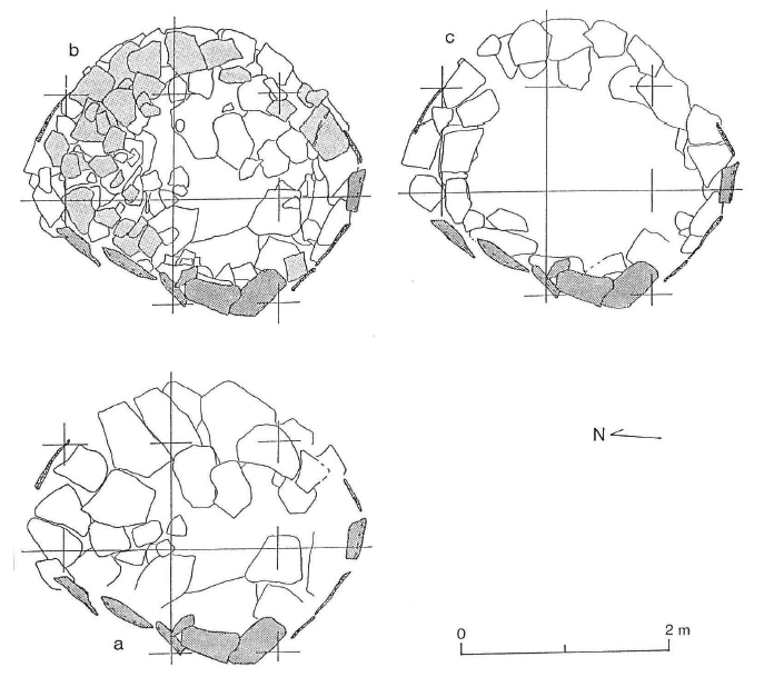 Figure 3 – Locality 385A, Feature 29: a, Slabs of lowest or floor layer;
b, All layers: Dark Shading are verticals still standing, lighter shading are probably
collapsed verticals; c, Ring formed by horizontal slabs of the middle layers
(Source: McDonald 2002a)
Raw material acquisition
Although I have been unable to locate any figures in the published sources, most of the tools made during Bashendi B appear to have been manufactured on quartz pebbles (Warfe 2003a) and grey nodular chert (McDonald 2002a, p.111), both of which was available locally on the Libyan plateau. Some beads were manufactured on limestone, which was again available locally. Types include
Exotic stones used for the manufacture of beads and toggles are confined to carnelian, which was available from the Eastern Desert, amazonite (green feldspar) which was available either from Tibesti in Chad or more plausibly from the Eastern Desert, and chrysoprase, for which a source in Egypt has not yet been located (Aston et al 2000; McDonald 2002a; Warfe 2003a). Pieces of worked quartz crystals, mainly white calcite, (McDonald 2002a; 2002b) were available locally (Mills et al 2003, p.9).
Ironstone and limestone were used for the manufacture of palettes and were both available locally (Adelsberger and Smith 2010; Warfe 2003a).
Of particular interest in this section is the acquisition of stone for the manufacture of upper and lower grinding stones thought to be used mainly for the processing of grass seeds. McDonald has suggested that Dakhleh and Kharga should be considered as a single cultural unit (McDonald 2006, p.4), which gives particular significance to the silicified sandstone grinding stone quarries of Kharga discovered by Per Storemyr during his 2007 participation of the North Kharga Oasis Survey (Storemyr 2014). Until this discovery it was not known whether stones were picked up on an ad hoc basis or whether they were part of a strategy of organized exploitation. At least for the Kharga and Dakhleh area, this discovery suggests the latter. A large quarry and at least three smaller ones occur along the same terrace of a small sandstone plateau and contain quartz-rich silicified sandstone workings, mainly rough-outs, accompanied by hammerstones and debitage of flint, which would have come from the limestone plateau along the northern margins of Kharga.
Clay for thin-walled and fine-tempered ceramics was locally acquired, although other ceramics were imports made on clay that was not local to the oasis (Warfe 2003a, 2008).
Marine shell, specifically conch, which was used to make armlets, bracelets and pendants, could have been imported from either the Mediterranean or the Red Sea, Dakhleh being equidistant between the two (Warfe 2003a, p.189) but given that the amazonite and carnelian suggest connections with the Eastern Desert, the Red Sea seems more plausible.
Food acquisition and production technologies
Lithic tool technologies
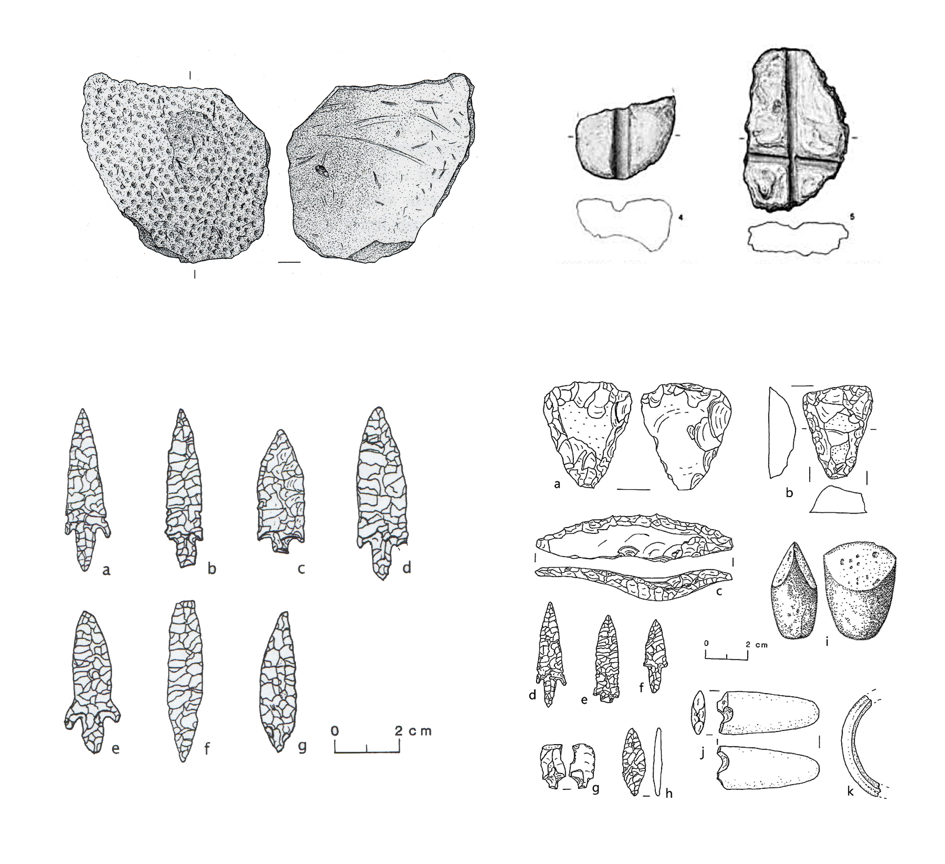
As usual for Western Desert sites, very little material survives apart from stone. This, however, is plentiful. Tools generally associated with pastoralism increase or appear. In a similarly flake-based industry tranchets and foliate-shaped bifaces are retained in Bashendi B, but there is an increase in scrapers on sideblow flakes with denticulates, notches, piercers and pressure-flaked tools including bifaces. However, differences are the absence of hollow-based arrowheads, a smaller range in the arrowhead corpus and a greater number of other types of tools including more tranchets, side-blow flakes (which are sometimes made on exotic stones) and scaled pieces on small pebbles (McDonald 1991b, 2001, 2002a, 2006, 2013, 2016). Types characterizing the Bashendi B include denticulates, scrapers (including tranchests and sideblow flakes), piercers, planes, and some arrowheads and a small number of crescents (McDonald 1996, 2002a). Examples are given in figure 4. New elements include stone palettes, toggles made of groundstone or exotic stones, and ornaments made of shell (McDonald 1996, p.93-4; 2008, p.100).
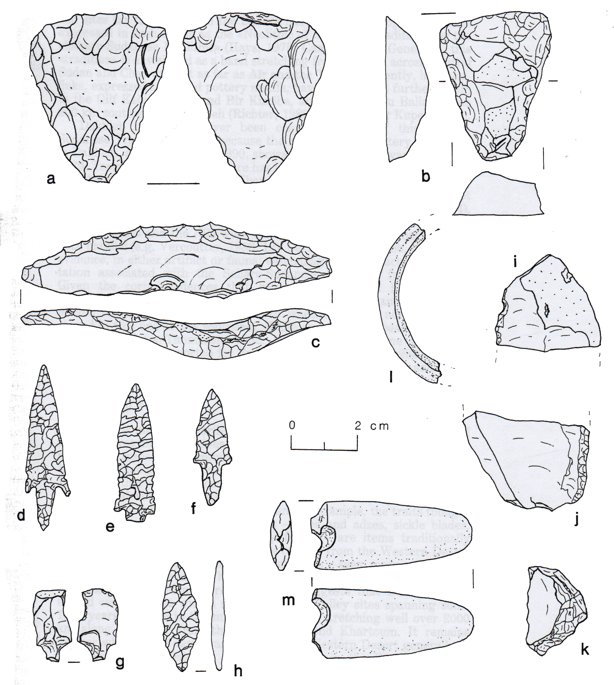 Figure 4 – Bashendi B artifacts: a, b, planes or tranchets; c, scraper on side blow flake;
d – h, arrowheads; i, ground stone axe; j, toggle fragment; k, shell bracelet fragment.
(Source: McDonald 2015, p.11, figure 9)
At Locality 271 lithic artefacts numbered 133 and included 40.6% denticulates, 17.3% piercers, 10.5% scrapers, 9% arrowheads, 7.5 % notches and less than 5% for other types. At Locality 385 lithics are made mainly on quartz pebbles and are dominated by denticulates (43.8%), planes (14.4%), combination tools (8.8%), piercers (8.2%), notches (6.2%), knives (5,7%), and the remainder represent less than 5% each, including scrapers, side blow flakes, drills and burins (McDonald 2002b).
Using Shea’s characterization of assemblages in terms of costs and benefits (2013, p.39-45), the toolkit from Dakhleh is a combination of optimized and more time-consuming approaches. The materials used are all available locally. The toolkit is consistent with other oasis pastoral assemblages in many ways, consisting of a flake-based industry with denticulates, notches and borers, bifaces, scaled pieces, and side-blow scrapers. Bifaces continue to be used, minus concave-based arrowheads and these take far more investment of time and energy than the standard flake based elements. The toolkit itself maintains connections with the Late Bashendi A whilst introducing new elements, arguing both for a continuity with previous activities and the need or desire for new functional components.
Although bifacial tool technology may have spread through the oasis areas as a particularly flexible way of reducing a tool (both tool and core in one) it may also have served other functions. Edmonds suggests that the concern with the precise shape and appearance of bifaces represent “a dual concern with form and function,” (Edmonds 1995, p.46) with the final form and its ongoing curation representing decisions about how the object should look as well as how it should work. The bifaces also represent a uniformity of design and a maintenance of traditional styles of artefact, in a way that may indicate that ideas and routines were being reinforced in the context of changing conditions, a concept proposed by Wobst (2000, p.47). Bifaces can be useful in a highly mobile environment because they can be curated rather than replaced (M.C. Nelson 1996, p.122).
Groundstone equipment
The groundstone tool kit is extensive. Not only are there grinding stones for plant and possibly pigment processing, but for the first time there are small and very well made polished groundstone celts (see figure 4 – i) and small palettes (McDonald 2013). Plant processing grinders are fairly uniform in design and are not conspicuously different from any other Western Desert examples with handstones and big mortars with slight dips in the top surface. Palettes are small and made of ironstone and limestone (McDonald 2001, 2007). Stone beads, discussed below, are also ground into shape.
Ceramic container technologies
As with the lithics there are notable continuities between Late Bashendi A and Bashendi B. These include small thin-walled open vessels and vessels with blackened tops. The Bashendi B pottery sample is relatively small with many sherds badly eroded, examples of which are shown in figure 6. All are coil-built and low-fired (Warfe 2018, p.38). Warfe says that little is known about the Dakhleh clays used in the manufacture of ceramics, but are both lacustrine and maritime. The latter would have been laid down during the marine transgressions of the Tethys Sea during the Paleozoic, Mesozoic or early Tertiary Periods (Sampsell 2003, p.140). There is only one complete vessel known from Bashendi B contexts. 300 sherds were retrieved from 17 sites in 2003, representing probably no more than 62 vessels (Warfe 2003b) and this number had risen to 98 by 2018 (Warfe 2018, p.38). Hope’s analysis concluded that most sites yield less than fifteen sherds each and many produced less than five (Hope 2002, p.42), but exceptions are Locality 212 with eighty sherds and Locality 254 with forty. Pottery is fine-tempered, and often thin-walled, with the temper consisting mainly of quartz, shale, limestone, anhydrite, sand, gravel and organic content (Warfe 2008, p. and is usually reddish-brown. Individual vessels tend to be small, thin-walled, and shaped into simple forms with a more frequent use of self-slips and real slips than in Bashendi A (Warfe 2003b). They are usually between 3.5 and 7mm thick with most falling within the range of 3.5-5mm (Hope 2002, p.41-2), but some are less than 3mm thick (Warfe 2018, p.38). An increase in the numbers of blackened-rim vessels are found, and shapes and sizes also expand (Warfe 2003b; Warfe 2018, p.10-12). Although no firing or kiln sites have been found, some seem to have been fired in very low temperatures and are friable and soft (Warfe 2003a, p.81) and Gatto (2012, p.61) suggests that shale inclusions indicate local production, but others were manufactured elsewhere.
 Figure 5 – Bashendi B ceramics from Localities 104, 116 and 212
(Source: Hope 2002, p.44, figure 2)
Warfe’s analysis indicates that there were 16 fabrics, of which the most common fabric is very fine sand and shale, Fabric 1A (at eleven sites) followed by Fabric 1B, fine sand and shale (at ten sites), Fabric 2A fine-shale rich (five sites) and 5B, fine sand, limestone and vegetal (four sites). Examples of 1A and 1B are shown in figure 6. Straw tempered fabrics have voids left by burnt-out straw temper. Some of these are thought to be locally made, particularly as local potters were using straw temper in Bashendi A before the imported examples appear, but others were probably imports. Possible outside sources for the pottery are Abu Gerara to the north, Abu Minqar to the west and Nabta-Kiseiba to the south (Warfe 2003a, p.84).
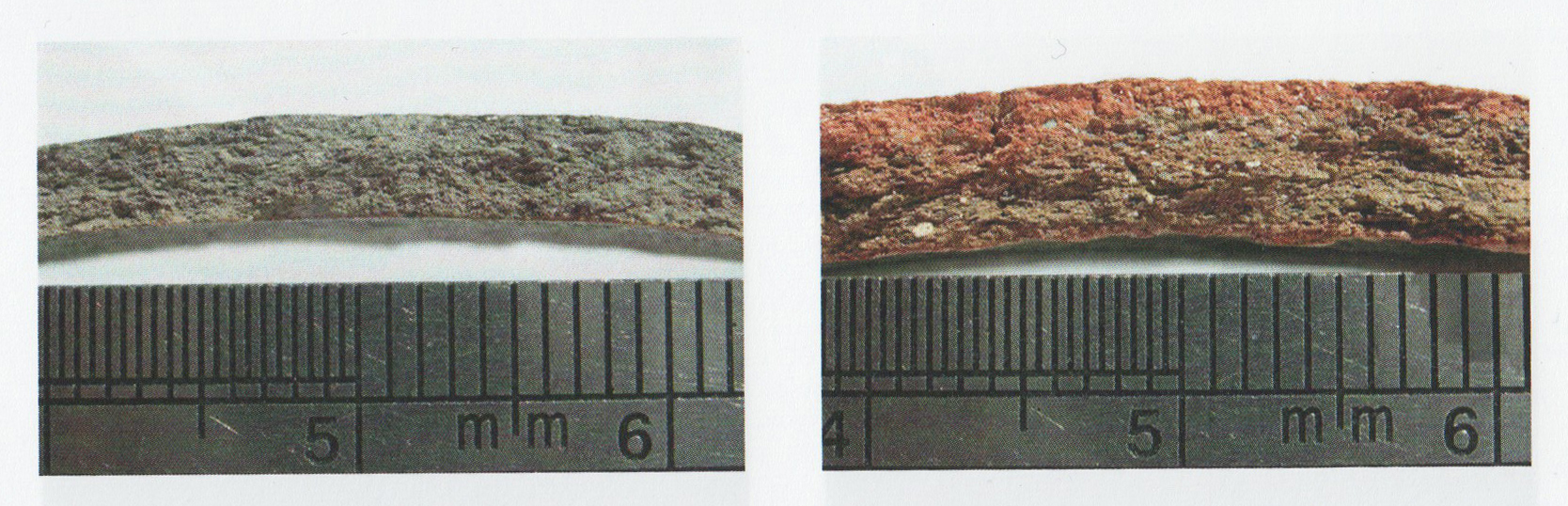 Figure 6 – Sections of fabrics 1A and 1B
(Source Warfe 2018, plate 3, figures a and b)
Coatings are used far more frequently than in Bashendi A, including self-slips and red slips with deliberate blackening of the upper exterior frequent, the latter a tradition established in Bashendi A (Warfe 2003a, p.81). Burnishing and possible polishing are other surface treatments. The number of shapes and sizes increased from those in Bashendi A. Some are hard but most are soft and easily broken. Jars include both wide-mouthed and restricted forms, with an infrequent number of jars that are narrow at the neck with a bulbous body. Most surfaces are even and smooth (Warfe 2018, p.40).
Decoration is more frequent and elaborate than in the Bashendi A but is still very uncommon, consisting mainly of oblique dashes, rim notching/incising and finger channelling (Warfe 2018, p.40). Undecorated sherds are dominant. The earliest examples of undecorated pottery are known from the Wadi el-Akhdar in Gilf Kebir with numerous sherds dating from 7700bp. By the 8th millennium bp it had extended to Dakhleh, Abu Ballas, Kharga and Abu Gerara (Warfe 2003b, p.84-5), so seems to have originated in the west and spread east.
Imports are represented by a number of small collection of sherds on Locality 74 preserve incised triangular and impressed dot decorations and are the most elaborate forms of decoration found in Bashendi B. All samples found were uncoated (Warfe 2003a, p.81). These are probably imports and are most similar to examples from Nabta, Jebel Uweinat, and Gilf Kebir (Hope 2002), and Khartoum and Shaheinab (Warfe 2003a, p.83). Gatto (2012, p.63) sees parallels with Petrie’s N-ware which does not emerge until the first half of the 4th millennium BC. Warfe also suggests that sherds from Locality 275 “are almost certainly imports” to judge from fabric, wall thickness and decoration, with affinities to Saharao-Sudanese Neolithic pottery, which is rare north of Nabta (2003b, p.83). Judging from the illustrations provided, they have affinities to Brunton’s Tasian (Brunton 1937; Friedman and Hobbs 2002), and to similarly shaped calciform beakers from the Eastern Desert, Gebel Ramlah, Aneibis, the Rayayna Desert to the southwest (Darnell, D. 2002 and 2008), Gilf Kebir, Jebel Kamil, and Laqeita in the Western Desert, (Linstädter 2007), Lower Nubia and Upper Nubia as far south as Khartoum (Longa 2011; Math 2006).
Some sherds that do not have shale inclusions might also be imports. Some contain calcareous inclusions (e.g. Localities 104 and 200W). Locality 212 produced a sherd decorated with an imitated basket design that seems to have analogues in the mid Nile valley (figure 6 – p) (Hope 2002, p.45; Warfe 2003a, p.81-82). Another fabric that appears not to have been local was a piece with rim-top decoration from Locality 74. Although three other sherds with the same decoration were found at the same site, what distinguishes this piece is that its fabric was sand-rich with no shale (Warfe 2003a, p.83; Warfe 2003b), which seems more closely related to southern Western Desert, Lower Nubian Abkan and Khartoum Variant types (Hope 2002, p.45). However, Warfe concludes that imports had no impact on local pottery traditions (2003b, p.84). It is possible that they were imported for their contents, which fits with Warfe’s observation that Dakhleh and neighbouring areas were part of “an extensive network of interregional contacts” (Warfe 2003a, p.85) and Riemer et al’s characterization of the oases as “a conduit of contacts between the north and south (Riemer et al 2013, p.168).
Craft skills
There are no bone tools found in Dakhleh, but it is almost inconceivable that bone was not used as a raw material for tool manufacture, particularly as a number of examples have been recorded from Farafra oasis to the north (Petrullo 2014, p.315-320), and a few from Kharga to the south (Briois et al 2012, p.185) have survived and suggest that bone tool technology was a common feature in oasis toolkits.
Ground-stone and polished jewellery, groundstone beads of amazonite, carnelian, crystal and limestone and perforated/modified shells are a new phenomenon and are apparently important to occupants of Dakhleh during Bashendi B (McDonald 1996, 2001). Flat objects painted at each end and pierced in the middle are thought to be toggles (see figure 4 – j) (McDonald 2002a, p.110).
Shells were used to make bracelets and pendants (for example, the bracelet fragment shown in figure 4 – k) although whether they were imported as finished pieces or worked at Dakhleh is unknown.
Although no cosmetics or pigments have been found in an archaeological context in Dakhleh, ochre was available locally (Vivian 2008, p.179) and the presence of small palettes, which became synonymous with pigments in the Badarian, may or may not indicate that pigments were ground and applied in the Bashendi B.
No examples of cordage, basketry, matting or weaving have been found but must have been present. As Hurcombe (2004) points out, whilst these activities often perish on archaeological sites, they were probably of considerable importance. Today the bulrushes and reeds that grow along the drainage lakes of the oases provide the populations with considerable material for successful mat, rug and basket weaving cottage industries (Ibrahim and Ibrahim 2003, p.54; Vivian 2008, p.183), and the cypereceae (sedges) discovered in Bashendi B contexts would have been perfect for the task.
Mobility
The small and temporary character of the sites, particularly when contrasted with the far more substantial stone-built settlements of the Bashendi A period, emphasise a mobile and lifestyle based on short term camps with frequent residential moves (McDonald 2002), the character of which is described under Subsistence Assets.
Economic structures
Although it has been suggested that a large stone built enclosure from the Late Bashendi A was a livestock kraal (McDonald 1998b, p.133), there are no similar structures during Bashendi B. This is probably because any structures would have been temporary due to the high degree of mobility practiced and because nomadic herding techniques would not necessarily require the confinement of livestock.
Cemetery / Religious architecture
There are no structures connected with funerary or numinous activities.
Food storage systems
Pits at Locality 271 contain the bones of cattle and goat, but none of the descriptions mention basket or mud lining so they do not appear to have been equipped with material to protect the contents of the pits against scavengers and insect infestations, perhaps indicating that they were either used to dispose of bones or were not intended for long-term preservation, or had another function entirely (McDonald 2001, p.34).
Fuel
Both dung (Linseele et al 2010; Evans-Pritchard 1940, p.258) and wood can be used as fuel. Domestic livestock and wild species could have provided some of that fuel. Wood would have been more readily available then in many other areas in Egypt thanks to the superior hydrological oasis resources, but at the same time, more concentrated populations may have counterbalanced this advantage and there may have been restrictions on its usage, as it is today (Bollig 2006, p.336-7; Hobbs et al 2014; Harir 1996; Wendrich 2007, p.74).
Transport
It has been suggested for other areas that cattle could have been used to carry heavier items like grinding stones (Close 1996, p.550), but in a relatively circumscribed area it would probably make more sense to leave heavy items at sites to which groups returned. Other items are small and generally very portable and could have been transported by people. Riemer’s research into outlying sites at Chufu and Meri found a grinder at Chufu site 02/17 where a grinder surface was scarred with rope marks and abrasions (figure 7) indicating that “it was obviously tied for transport” (Riemer 3006, p.518).
 Figure 7 – Ginder from Chufu site 02/17 (Source: Riemer 2006,
p.511, figure 14.2 – 2)
Similarly, grooved abraders were also found at sites 00/81 and 00/82 at Meri (figure 8). These were temporary wet season sites that, being up to 100km southwest of Dakhleh, would have merited carrying items rather than leaving them.
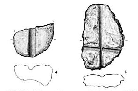 Figure 8 – grooved abraders from Meri sites 00/81 and 00/82
(Source: Riemer 2006, p.511, figure 14.2, – 4 and 5)
Craft infrastructure
There are no signs of any structural components associated with craft manufacture. The manufacture of pottery was probably local, but apparently did not require the high temperatures and controlled heat that required kilns.
3.1.3 Social Assets
Status, roles and social organization
Although there are no permanent settlements and occupation remains tend to be somewhat ephemeral, McDonald suggests that the presence of certain materials and objects may be prestige items indicative of differential access to luxury items and an emerging inequality at Dakhleh (McDonald 1999; McDonald 2008 p.100, Table 1). As in other mid-Holocene areas, ostrich eggshell beads virtually vanish in Bashendi B, although they were rich in Bashendi A. However other objects could have served the same role. These include almost twice the number of bifaces than in Bashendi A, more exotic stones, a greater variety of ornaments and new items as follows (McDonald 1996 p.93-4; McDonald 2008, p.100):
- beads made of exotic stones, including carnelian, chrysoprase, amazonite (feldspar) and quartz crystals
- worked quartz pebbles and crystals
- labrets in white polished stone, mainly calcite
- pottery
- unworked shells
- “Elaborated practical tools” and technologies, particularly bifacial knives
- bracelets and pendants made of shell (see figure 4 – k)
- small ground and polished stone celts or axes (new)
- toggles made of groundstone or exotic stones, including carnelian, chrysoprase, amazonite (feldspar) and quartz crystals (new) (see figure 4 – j).
- palettes in limestone or ironstone (new)
The stones and shells to which McDonald refers were exotic in the sense that they were not available in the immediate locality of Dakhleh and would have had to be acquired, the nearest source of which were the Nile valley for the freshwater shells and the Red Sea mountains for the stones and sea shells, the latter raised to the surface in the geological process of the Red Sea uplift. It would have taken knowledge of the landscape and the ability to locate such stones to source them, and the mechanism by which they were acquired is not known. The concept of prestige items may have been transmitted from the Sudan, where similar labrets are found, a very distinctive item are found in the richest graves (McDonald 2008, p.102). McDonald concludes: “the marked increase in types of prestige technologies, all of them now producing arguably competitive prestige items, might suggest greater social complexity – more pronounced ranking – than in late Bashendi A times” (McDonald 2008, p.102).
In pastoral societies there is often a liminal zone between leadership and prestige, where roles are fluid and people may have influence over certain areas of life but not others, and which may be mutable on a seasonal or other basis (Wachuku 1979, p.247). In other cases formalized structures are in place to manage internal rules, disputes and to mete out justice (Dika Godana 2016; Honeychurch 2014; Robertshaw 1999) and complex social structures may develop (MacDonald 1998). Where resources are limited and populations and livestock need to avoid over-exploitation of the areas around permanent water sources, it is probable that roles were allocated that involved varying levels of responsibility over people, territory and key resources, with authority allocated to certain individuals or councils of individuals to enforce both formal and informal rules that are learned from birth (Berkes et al 2000, p.1254; Niamir 1991, p.7). This can be exemplified by the Borana of Ethiopia who have various types of leadership role and council that relate directly to livelihood management and are based on household, village and territorial units. At each scale there are leaders and councils (Dika Godana 2016). Households have the initial responsibility of educating children about regulations within society and how to manage resources. The next level of responsibility is the village, each of which has a head of village. A cluster of villages, a Reera, has a head of cluster “a famous man who has the ability of managing rangeland and water resources of the Reera area” (Dika Godana 2016, p.5). A wider territorial unit is the Madda, made up of a combination of clusters and is administered by a council of elders drawn from the Reera. The widest unit is the Dheeda, which are managed by a council of elders chosen from the Dheeda and is usually concerned with grazing zones. Disputes over mobility and grazing rights are often resolved at this level. At the same time, responsibilities exist for specific tasks or resources. For example, a well manager is assigned to co-ordinate water rights and the men who lift water from the well and keep the well zone clean (Dika Godana 2016, p.5-6), a practice known amongst other African groups where wells are an important part of sustainable livelihood management (Niamir 1991). The management of springs within Dakhleh were probably subjected to similar types of rights management and scheduling (Bardhan and Ray 2008; Binns 1992; Dasgupta 1997; DFID 2000a; IFAD Rural Poverty Portal 2007; Ostrom 2008). In other places different types of management regime exist that offer the same types of monitoring and enforcement systems. Whilst councils of elders are common, shamans or other religious leaders may also be given authority over the co-ordination of rules within and between groups, and some of these roles may be fluid with one individual carrying out multiple roles (Berkes et al 2000, p.1254; Niamir 1991, p.7; Olupona 2014, p.40). Nelson et al (2016, p.299) emphasize that “vulnerability to climate challenges is mediated by institutional structures that are constantly changing” and it is likely that any organizational structure was essentially dynamic over time.
Although there are no funerary remains and therefore no indicators as to the differential roles of men and women, it should be remembered that today women do have important economic roles in pastoral communities, may have ownership of animals in their own right, can head families and may be important contributors in the negotiation of disputes (Deng 1972, p.108; Gritli 1997).
Religion, ideology and spiritualism
Apart from rock art, which is not tied into any particular phase of the Dakhleh Neolithic and therefore unusable, there is no indication of any unambiguously religious or ritual activity in Dakhleh. This does not mean that there were none, and it is extremely unlikely that there was no interface between the everyday world and the supernatural, but there are few signs of it at the oasis sites. McDonald does not rule out the ritual slaughter of animals at Locality 271, where numerous livestock remains were found, citing the cattle tumuli at Ru’at el Banat Nabta as a contemporary example of cattle-based numinous activity (McDonald 1998b, p.134). The other possible indicator is the importance of personal ornamentation, which in the Sudan, Gebel Ramlah and Badarian are associated with graves and seem to be associated with a growth of the importance of both personal and group identity. In Namibia, the Herero and Himba are culturally very similar but differentiate themselves from one another by use of clothing and ornamentation (Friedman 2011, p.269), and for the Himba personal elaboration for both sexes and all ages is fundamental to their personal and group identity (Abati 1998, p.183-190). Although there are no burials located in the Bashendi B, meaning that there are no funerary practices or grave goods to work with, the importance of ornaments made of exotic materials may have been connected to new ideas about how people’s roles were changing and how they were perceived.
Berkes et al (2000, p,1256) make the point that the success of ecological management strategies is always regulated by social mechanisms, which often include various aspects of religion, taboo and worldview or cosmology. Although the expression of belief that connects with the supernatural is not visible at Dakhleh in Bashendi B, it was probably there in some form.
Ritual and rites of passage
The lack of data makes any proposals in this section purely speculative, but the presence of personal ornamentation that in other areas was connected with funerary contexts, for example at Gebel Ramlah at Nabta in the Final Neolithic (Kobusiewicz et al 2010), and the Badarian (Brunton and Caton-Thompson 1928; Brunton 1937, 1948; Wengrow et al 2014) could indicate that these were just as important to rituals of living as to those associated with the dead. They could also be symbols of role or prestige, as McDonald suggests (McDonald 1999; McDonald 2008 p.100, Table 1) but it is also possible, for example, that bracelets, toggles, labrets and beads may have been connected with rites of passage. For example, in modern groups such is the Himba of Namibia and the Fulani of Nigeria (Abati 1998; Lambrecht 1996) certain items of clothing, ornamentation and hair style are adopted only when a certain age is reached, or when a specific ceremony is carried out, thereby linking rites of passage with personal prestige and new responsibilities. The presence of ornamentation in other areas accompanies the beginning of funerary practices dominated by single inhumations and in those cases seems to indicate the importance of the individual identity and roles.
The lack of ritual data is not evidence of a lack of ritual activity. Many ritual activities leave no physical remains, or remains that are so ephemeral that they do not survive or are very difficult to interpret when they do (Droogan 2013, p.50). Later, it will be argued that the Dakhleh nomads made considerable use of different types of landscape in Dakhleh and would have been intimately familiar with all aspects of their habitat. Bollig (2010) discusses how the Namibian Himba link their all-important genealogies to the landscape, imbuing the land with history, meaning and morality, reinforcing bonds between kinsmen. Kavari and Bleckman (2009) discuss how semi-nomadic Otjiherero pastoralists in northwest Namibia practice praises of places called “omitandu.” This is an oral tradition that leaves no material remains but is an essential component of marking place and time. It references the collective memory of the community, capturing aspects of history that it was thought should be remembered such as concrete items like people, lineages and events, or less easily definable aspects of living, like landscapes and places. Lack of evidence of such celebrations does not mean that such conceptualizations and linkages were not made.
Tradition and social values
The idea of tradition is one of mutability, the use of accumulated experience to adapt and change, whilst building on existing wisdom and values (Spencer 1998, p.249). Hunn describes traditions as “the product of generations of intelligent reflection tested in the rigorous laboratory of survival” (Hunn 1993, p.13). Shared social values and guidelines, like rules of behaviour, and concepts of right, wrong and justice are largely unidentifiable in a prehistoric archaeological context, but tradition may be observed, and it is suggested that where strong traditions are adhered to, the underlying conventions for handling dispute, disagreement and infringements will have been formulated and practiced.
Although there is no major break with economic life between the Late Bashendi A and the Bashendi B, and the apparent gap between the two has now been partially bridged by two radiocarbon dates (McDonald 2013, p.185-6) there are differences, notably technological developments mainly in lithics, the increasing dependence on domesticates, an increase in the importance of personal ornamentation and, most importantly, the switch from sedentary or semi-sedentary lifestyles to full mobility. In addition, McDonald suggests that the low economic role played by domesticates during Late Bashendi A, when their adoption may have been “primarily for social reasons,” this is not true of Bashendi B where the pastoral component was economically important (McDonald 2013, p.180). However, in spite of these rearrangements of living conditions there are no signs that people felt the need to separate themselves from the past, or to develop new relationships that might influence their cultural output in a significant way. In this it differs from the other case studies, where the adoption of domesticates was accompanied by other changes in the material record. Strong cultural indicators like pottery manufacture and lithic tool production are sustained from one period to the next, and whilst new tools and types of pottery are found, these add to rather than replacing former types. If it is valid to link observations of material output with ideas about tradition and social values, then there does not seem to have been a crisis of identity. This might be seen as lack of opportunity, but it seems clear that Dakhleh had contacts with other oases (Warfe 2003a, p.85; Riemer et al 2013, p.168) and that the choice to maintain existing traditions was not due to lack of exposure to other types of material and other ideas, but had more to do with maintaining an affiliation with other the other oases, which shared a very common material culture. In an environment driven by refugia and unpredictably watered surroundings, the maintenance of such affiliations would presumably have been important for maintaining stability and security within and between groups using the same local and broader territories. Ceramics suggest an intensified connection with the Nile, with which they have affinities. Ceramics are not a part of the traditional oasis repertoire and are absent in Farafra and Djara (Riemer and Kindermann 2008, p.621-2),
The continuation of biface manufacture is of particular interest, as many of the tools might have achieved the same result with far less input of time and energy. Although projectile points are less varied in size and shape than Bashendi A, and hollow-based arrowheads vanish from the assemblage, bifaces are still prominent (figure 9) (McDonald 2013, p.185). McDonald emphasises that bifaces are associated with hunter gatherers during Bashendi A rather than with the later introduction of cattle and goat. Shirai has proposed that in Egypt bifaces were a response to botanical changes that arise during the Holocene wet phase from c. 5800BC leading to new animals entering the area and a need for new tools to hunt these species that had not been encountered before, perhaps associated with new hunting strategies that included stalking and hunting (Shirai 2006, p.358-9). In the Dakhleh area they are found earliest in the Limestone Plateau where there is abundant good quality raw material available, and this was also imported into the Nabta area (Riemer 2006; Riemer and Kindermann 2008; Shirai 2006, p.363). Shirai suggests that the hollow-based arrowheads were used to take down slow and tough-skinned animals like elephant and giraffe. The absence of this particular type of arrowhead in Bashendi B could reflect the retreat of the ITCZ which would have taken those species with it. However, other elements of bifacial tool technology were retained. As bifacial points are not suitable for hunting fast moving animals, and were probably developed as a response to “the decline of encounter hunting and the emergence of a certain degree of sedentism combined with logistical mobility” (Shirai 2006, p.360), which fits with Bashendi A and Late Bashendi A, the retention of the technique in Bashendi B requires explanation. Wild species in Bashendi B are dominated by gazelle and hare in human assemblages, which according to Shirai’s research are unsuitable prey for bifacial tool users (Shirai 2006, p.364).
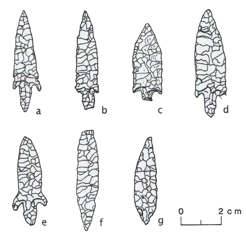 Figure 9 – Bashendi B bifacial arrowheads
(Source: McDnald 2013, p.185, figure 7)
Barkai suggests that bifacial tools were “much more than simply a solution to a technological problem and that they “could also hold a profound social significance, drawn upon in the construction of ideas about identity and in the negotiation of relationships” (Barkai 2011, p.6). Barkai was looking at PPNA and PPNB items in the Near East and the transition from hunting and gathering to sedentary agriculture, but his observations about the amount of work put into such tools are just as valid here, as bifacial tools are obviously an essential differentiator here too between purely hunting and gathering livelihoods and alternative livelihood strategies, perhaps linking “symbolic elements with social situations, giving them new values” (Barkai 2011, p.12). Gero’s proposal that some tools function to “form, maintain and transform social relationships” seems appropriate here (Gero 1989, p.92). The bifaces correspond to three of her five axes of variability: the small size being transportable and easily exposed, the longevity promised by the ability to curate the tool, and the number of production stages involved. Gero suggests that tools like this were particularly relevant where rights, obligations, territorial privileges and specific economic statuses were in play (Gero 1989, p.92), all of which would apply here. Although most of the raw materials were available locally, there is still an investment in manufacture that almost certainly exceeds the requirements of the strictly functional. Shirai similarly sees symbolic meanings associated with bifaces, citing group identity, symbols of hunting prowess, associations with sharing following butchery and competitive aestheticism under conditions of stress as possible motives (2006, p.367). Whatever the precise symbolic value embedded in these tools, the maintenance of those values was apparently of importance in the oases. In Farafra oasis, the next oasis north in the crescent of Western Desert oases, and at Djara to its east Lucarini has suggested that some bifaces “may have been status symbols and can be interpreted as cult objects or offerings,” particularly those with regular parallel detachments or no use wear, and where they were too thin or fragile for practical use (Lucarini 2012, p.89). None of the few published lithic illustrations from the Bashendi B (McDonald 1991 p.49; 2013. p.185) show the same dedication to aesthetics that certain examples from Farafra and Djara demonstrate, although I assume that the most exceptional have been chosen for publication. The bifacial points in particular do demonstrate high skill, but not to the point where their appearance and skill appear to be more important than their function, as proposed for some bifacial knives by Shirai (2013, p.226). Instead, they appear to combine indicators of identity with risk-handling strategies where specialized tools were employed to complete certain tasks within economic strategies that include hunting and larger species. This concept of identity may have been both personal, reflecting the maker and his or her status, or be more indicative of cultural affiliation.
At the same time new elements may indicate the establishment of new relationships as well. The presence of ground stone celts, new in Bashendi B (McDonald 2001) may have been designed for more than purely functional purposes, as they are often associated with more specialized and socially constructed ideas (Barkai 2011, p.8), and the addition of personal ornamentation familiar from Gebel Ramlah to the south and from the Nile valley in the Sudan (Gatto 2009; Wengrow 2006; Wengrow et al 2014) suggest that contacts were influencing new ideas, perhaps indirectly via trade, perhaps directly via exogamy. Rim sherds and body sherds with “incised triangles filled with vertical or horizontal rows of impressed dashes or dots, apparently arranged in several rows between incised lines . . . made in the typical fine quartz- and shale-tempered fabric but with uncompacted, blackened or greyed surfaces” (Hope 2002, p.42) also suggest that as well as objects, ideas were also in transit. They are highly distinctive and have been found in both cemetery and settlement contexts elsewhere, and seem to have been part of a calciform beaker tradition from the Badarian in the north to the Sudan in the south and as far as the Gilf Kebir in the west (Dittrich 2017, p.139, Fig.10; Hope 2002, p.42). Only a remains were found at Dakhleh at Locality 74 (figure 10) (Hope 2002, p.42). It is possible that they were associated with a range of ceremonies and rites that were shared in spirit if not in nuanced meaning between areas as far north as Mostagedda in southern Middle Egypt and the Khartoum in the Sudan (Longa 2011, p.16).
 Figure 10 – Bashendi B sherds with incised triangular shapes
(Source: Hope 2002, p.43, Figure 1).
Finally, and in the spirit of pushing the data to its absolute limits, the absence of sheep, desert hare and ostrich are all peculiar. All would have been suited to life in Dakhleh, and were found during excavations at a contemporary site in Kharga KS043 (Briois et al 2012), although cape hare is also only represented in low numbers at KS043, so may have been a preference. In looking for a solution to the problem that moved beyond destruction of the data, it is possible, although improbable, that these were absent due to food taboos. There are examples amongst modern groups where highly surprising food taboos exist, some of which may be detrimental to human health, particularly at some parts of the year, during significant processes like pregnancy and during rites of passage (Asi and Teri 2016; Pérez and Anna García 2013). A more plausible alternative is that they were simply not a preferred food item, offering little value in return for acquisition costs.
Material expression
Bifacial tool technology is a clear example of material expression in Dakhleh, exceeding what was strictly speaking required for the function they performed as discussed above. Beyond the potential role they played in the maintenance of traditions they have a certain aesthetic appeal, which may have developed symbolic values and associations. That this is not merely a modern construct is borne out by the extreme contemporary examples found at Djara and Farafra, where implements were beautifully made and were never used. They seem to be a good example of what Sillar and Tite (2000, p.9) refer to as “materials and techniques embedded within and [which] therefore may be dependent on wider cultural values and ideological concepts that stretch beyond any single technology.” The whole family of bifacial tools seems to have become very much part of the sensory environment that Gosden identifies (2001, p.165-167) when he says “Aesthetics need not emphasize concepts of beauty or a refinement of taste, but rather the full range of evaluations any culture makes of its objects.” Everyday items into which additional care was invested are “highly charged objects,” differentiated from other objects that do not tract the same attention and respect (Gosden 2001, p.166), mediating between people’s physical activities and their wider livelihoods and worldviews and experienced on a very personal level when they are manufactured with such care and intricacy. As well as being part of a wider identity associated with the oases and related areas before and after the introduction of pastoralism, they required a considerable amount of individual input and were therefore part of a deliberate contribution to what Gosden refers to as a “sensory environment” (2001, p.166) and which Sillar and Tite refer to as “practical possibilities being reviewed and selected through cultural criteria” (2000, p.9). As Sillar and Tite point out, creativity and meaning may be just as embedded in technological as in religious output.
Ornamentation, which became very important towards the end of the mid-Holocene in various areas, from the Sudan to the Badari region and at Gebel Ramlah in the Western Desert, is also found at Dakhleh in the form of toggles, labrets, beads and bracelets, many of them made of exotic stones and both marine and fresh water shells. Personal ornamentation is important to many modern African groups, such as the Himba (Abati 1998) and the Nigerian Fulani (Lambrecht 1976), with considerable time lavished on clothing, ornaments, body paint and hair styles.
In his discussion of the Kalahari San, Wiessner contrasts the role of headband styles, by which people identify themselves with particular roles, thereby promoting mutual dependencies with the role of arrow styles, which emphasize conformity to norms and play down individual and social differences (Wiessner 1984, p.227). A similar relationship might be found in the Bashendi B between personal ornamentation and the broader social messages incorporated into bifacial tools.
Ceramics at Dakhleh are more difficult to evaluate. Dominated by specific fabrics and very plain treatments, ceramics are more plentiful than in the Bashendi A but are usually represented by only a few sherds at sites where it is found. It does not appear to have been a dominant component of cultural expression. This is consistent with other types of data. Pottery was not a component part of a northern oasis or related tradition. There is almost no pottery at Farafra or Djara, two main concentrations of occupation in the period contemporary with the Bashendi B (Riemer and Kindermann 2008, p.621-2), and the Dakhleh pottery has more affinities with the Nile than the desert. The choice to express affiliation with an oasis identity via the lithics and a Nile identity via the ceramics seems to imply a concern to integrate into both areas, either for subsistence or social reasons, or for both.
Sillar and Tite state that continuity of any industry requires the maintenance of access to raw materials, energy sources, techniques and tools as well as the ideas that are shared by producers and consumers (2000, p.12). The enduring material character of Bashendi B over several hundred years, with a notable degree of continuity from the Bashendi A (McDonald 1996) argues not only that productivity was sufficient to feed the population or that populations were modified by the outcome of poor production, for example by high infant mortality and early adult death, but that there was a consistency in economic and social life to prevent major changes in material expression, which would be expected to reflect any major breakdowns in or alternations to subsistence, social traditions and worldview.
Mobility
It will be explained the next section that mobility was not only practiced but was an essential livelihood management strategy in Dakhleh during Bashendi B. Social changes must have accompanied the change from semi-sedentary living in stone built enclosures in the Late Bashendi A to the full mobility apparent in Bashendi B. People would have had to negotiate the land, encampments and each other in a very different way.
Another aspect of mobility may have been the need to meet up with other groups at certain times of year. For example, S.E. Smith (1980, p.479) describes how the Kel Tamasheq of southern Mali aggregate during the wet season when the needs of their livestock are not actually the dominant factor, to enable them to engage in trade and social activities and to secure marriage partners. McDonald suggests that site 271, a much denser than average site, may have served as just such an aggregation point (McDonald 1998b, p.138).
Craft manufacture
There are no indications in the publications of specialized areas for working of stone tools, but then there are no discussions of cores or debitage either. In the absence of any mention of sites where only cores, rough-outs and debitage are mentioned it is assumed that tool manufacture took place around hearths at campsites.
Ceramics were not made in huge numbers but were apparently made locally. Without the need for or knowledge of kilns, vessels appear to have been made on a fairly ad hoc basis. As no remains of even informal pottery manufacturing pits have been found to date, seems probable that this activity was separated from the encampment.
Internal relationships of trust and care
This has been consistently difficult to assess throughout the case studies due to the lack of archaeological markers for this sort of relationship. For example, ethnographic research confirms that such relationships were important and often took the form of livestock loans and reciprocal agreements regarding how these should operate (Bollig 2009, p.285-290; Harir 1996, p.89-90; Jallow 1990, p.195; Legge 1989). Extended family networks are important for exchanging knowledge and information, providing marriage partners and facilitating migrational movements. However, none of this is visible archaeologically. Craft items might be exchanged locally, and communal activities help reinforce group stability. Apart from possible aggregation sites at localities 271 and 276, where communal activities may have taken place, and the availability of livestock and craft output for internal exchange, there are no other signs of internal relationships.
Inter-group relationships
The main depressions of the Western Desert form a crescent from south to north, and include Kharga Oasis, Dakhleh Oasis, Farafra Oasis and Bahariya Oasis, with the Faiyum Depression completing the crescent at the north (Sampsell 2003, p.90-92). This arc of refugia and related sites in the surrounding desert share many archaeological features, including bifacial tool technology and domesticates. The bifacial tool technology of Bashendi A and B, Djara B and the Faiyum Neolithic are particularly distinctive and have many similarities (Shirai 2006b). Whilst notches and denticulates seem to have been common to most Western Desert sites in the later early Holocene, tranchets and side-blow flakes are found widely over the same area in the mid-Holocene. Celts also appear in Bashendi B but are also known in small quantities in the Faiyum and Merimde to the north, in Western Desert assemblages, in Badarian assemblages (identified by Brunton as Tasian) and in the Khartoum Neolithic (Trigger 1983, p.41). Warfe see the closest similarities to those from the Sudan (Warfe 2003a, p.185).
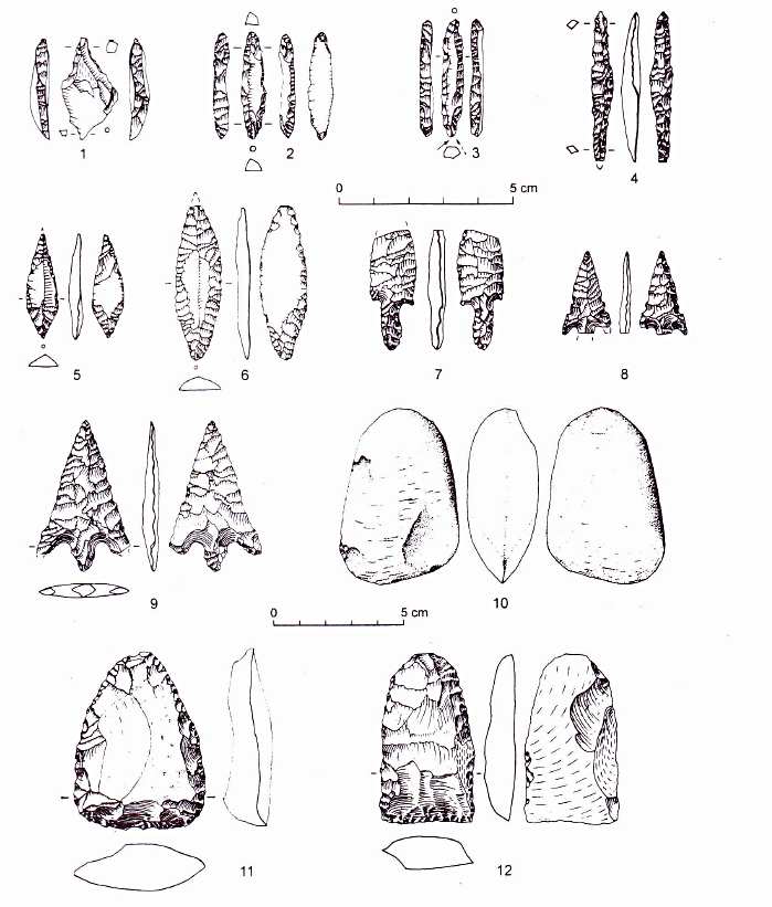 Figure 11 – Lithics from Abu Gerara. From Riemer 2003, p.81
The earliest undecorated pottery is known from the Gilf Kebir in Wadi el-Akhdar, and apparently spread east from there to Dakhleh, Abu Ballas and Lobo; it is also known from Laqiya and Nabta (Warfe 2003a, p.84). Some of the straw-tempered fabrics are possibly imports. Possible outside sources for the pottery are Abu Gerara to the north, Abu Minqar to the west and Nabta-Kiseiba to the south (Warfe 2003a, p.84). A small collection of sherds on Locality 74 preserve incised triangular and impressed dot decorations and are the most elaborate forms of decoration found in Bashendi B (figure 10). All samples found were uncoated (Warfe 2003a, p.81). These are probably imports and are most similar to examples from nearby Kharga (Briois et al 2012) and more distant areas like Nabta, Jebel Uweinat, and Gilf Kebir in Egypt (Hope 2002), and Khartoum and Shaheinab in the Sudan (Warfe 2003a, p.83). Some sherds that do not have shale inclusions might also be imports. Some contain calcareous inclusions (e.g. Localities 104 and 200W). Locality 212 produced a sherd decorated with an imitated basket design that seems to have analogues in the mid Nile valley (figure 6 – p) (Hope 2002, p.45; Warfe 2003a, p.81-82). Another fabric that appears not to have been local was a piece with rim-top decoration from Locality 74. Although three other sherds with the same decoration were found at the same site, what distinguishes this piece is that its fabric is sand-rich with no shale (Warfe 2003a, p.83; Warfe 2003b, p.5), which seems more closely related to southern Western Desert, Lower Nubian Abkhan and Khartoum Variant types (Hope 2002, p.45). On the basis of the pottery imports, lithics, items of adornment and exotic materials Warfe suggests that Dakhleh and neighbouring areas were part of “an extensive network of interregional contacts” (Warfe 2003a, p.85). However, in spite of Hope’s observation that general traits rather than total transference should be sought when looking for influences (Hope 2002, p.178) there are few direct parallels between Dakhleh and the Nile valley (Warfe 2003a; Tangri 1992; Riemer 2006).
As suggested above, although marine shells could have been sourced from either the Red Sea or the Mediterranean, links with the Eastern Desert suggest that the Red Sea was more probable. This is supported by finds of pottery with a decorative scheme consisting of triangular motifs and impressed dots from Locality 74 mentioned in the previous paragraph. Having said that, Lucarini argues for a “corridor” between the Egyptian Western Desert and the North African coast on the basis of similarities between the bifacial traditions, including side-blow flakes, of the oases and Haua Fteah as well as other Libyan sites of the same period, which are contemporary with Late Bashendi A and B, Farafra B-C and Djara B (Lucarini 2013).
Although Warfe considers it unlikely that Dakhleh’s pottery had much impact on the Badarian (Warfe 2003a, p.191) there may have been links with the contemporary Badarian, or more indirectly with traders or trading encampments related to the Badarian, which might account for Eastern Desert stones and the appearance of shell bracelets and pendants. Other sources of these items could have been Gebel Ramlah near Nabta Playa to the south or Sudanese sites such as Kadero both of which shared many of the same features at broadly the same time. Warfe sees greater similarities between the Tarifian and Dakhleh than the Badarian (2003a, p.192). In general terms, Hope says that the ceramics show a greater level of contact between Upper Egypt than Lower Egypt (Hope 2002, p.58).
Darnell (2002, p.169) suggests, on the basis of ceramics and other evidence, that Libyo-Nubian groups in the region between Kharga and the Nile are related to A-Group and Abkan groups and that Brunton’s still controversial Tasian may have evolved from the same cultural complex. She suggests that southern traits entered the Upper Egyptian Nile Valley via the Western Desert. A lot of the difficulty with discussing direction of influence is that tying in precise chronologies is very difficult given that the transmission and assimilation of ideas is very difficult to date. For example, it is hypothetically possible that undecorated pottery entered the Nile valley from the desert towards the end of the Holocene, but it is equally possible that this idea was refined and developed in the Nile valley and was spread in this more refined form to other areas, including back into the desert. Partly due to the proposal by Hassan (1986a; 1988) and others that small groups migrated to the Nile during the 7th millennium bp, there has been an emphasis on a west to east drift of cultural traits (e.g. Hope 2002; McDonald 1996; Tangri 1992), but it is by no means clear if it is even reasonable to suggest a one-way transmission of ideas and identity. As Hassan emphasises, even when groups did move into the Nile valley, it would have been a gradual shift in small stages, not a wholescale migration of all desert occupants at one time, and assimilation and sharing of ideas may be identifiable but not in terms of replacement or unmodified transfer of material components.
Kuper and Riemer (2003, p.49) suggest that the full extent of movement between oasis and surroundings did not exceed 100km, reaching as far as Meri and Chufu to the southwest but no further (Riemer 2006). Movement appears to have been seasonal and ranging onto the Abu Muhariq (or Egyptian Limestone) plateau seems to have taken place during the rainy season (Riemer 2003). On the basis of her studies of shale wares, which are found from the second half of the 6th millennium BC at the oases of Dakhleh and Kharga, on the Abu Muhariq plateau, at Abu Ballas and in the Rayana desert as well as and in Nabta during the 4th millennium BC, Gatto suggests that the archaeological evidence indicates that “it is likely that groups of herders were seasonally moving from the oases to the Nile looking for pastures” (Gatto 2012, p.70). The oases probably served as a corridor between north and south (Lucarini 2013), with territorial boundaries, kinship divisions and social conventions constraining and enabling different types of relationship, information exchange and communication of knowledge. The maintenance of kinship relationships and the acquisition of marriage partners (MacDonald and Hewlett 1999; Whallon 2006) may have been relatively easy to maintain when clearly defined areas are concerned, enabling the formalization of contacts and the development of structured relationships. There is no evidence of conflict between these areas, but the presence of rock art and the investment in elaborate bifacial tools at Dakhleh, Kharga, Farafra, and Djara are suggestive of structured identities and the relevance of religious and ideological concepts. The concept of a “shared visions of space” identified by Calvo et al (2016) may be particularly applicable here, as groups had to negotiate frontiers between the oasis and the pastures and other resources where territories met. The Abu Gerara plateau, for example, to the north of Dakhleh and south of Djara and southeast of Farafra is chronologically comparable with Dakhleh B and Djara B and indicates close connections with Dakhleh, particularly in terms of pottery and lithics (Riemer 2003). The shared bifacial technology between all the oases and the Faiyum depression suggests that the oases are comparable to an archipelago. Calvo et al, writing about the four Iberian Balearic islands in the western Mediterranean, describe “a scheme of interactivity,” sharing cognitive ideas derived from a common set of economic and symbolic activities. Both the Mediterranean and the Western Desert were navigable but required particular skills to do so, and the material similarities suggest an importance in maintaining connectivity.
Kharga and the Faiyum were accessible to the Nile as well, suggesting that contacts along both the north-south axis of the Nile valley into the Delta in the north and the Sudan to the south would have been encountered. The Theban Desert Road Survey (TDRS), working between the Valley and Kharga Oasis has been recording sites between the two areas and demonstrating close ties between them throughout the Predynastic, confirming that a desert route to the Nile was used (D. Darnell 2002; J.C. Darnell 2002). McDonald sees the undecorated pottery of Bashendi B as being influenced directly or indirectly by Khartoum types, although there are significant differences perhaps due to the different uses to which such vessels were put (McDonald 2016, p.191) and the ideas associated with them. She also sees similarities between the white polished labrets of Dakhleh and those in the richest graves of central Sudanese Kadero as described by Krzyzaniak 1991, p.523 (McDonald 2008, p.101). McDonald also suggests that the concept of possible prestige items may have been transmitted from the Sudan, where similar labrets are found in the richest graves (McDonald 2008, p.102).
Additionally, the narrowest routes across the Eastern Desert to the Red Sea were in the Luxor region, and the Kharga connection to the Nile would have provided access to people, products and ideas coming from this direction, Shirai (2006b, p.13) suggests that since the introduction of ovicaprids from the Red Sea area into the Western Desert there was probably a constant movement of people between the two areas.
Dakhleh was well placed to develop and maintain relationships that supported livelihood maintenance even under conditions of unpredictable environmental conditions and living under circumscribed conditions that were very different from those experienced in the previous early Holocene. It appears that Dakhleh fed into and received from a wide network of contacts during the mid-Holocene, probably connected by common needs, and that these were very widespread. Warfe’s suggestion that items “were distributed across the central desert regions as a ‘package’ of sorts” does not seem farfetched (Warfe 2003a, p.194). Although this ‘package’ was not transmitted in its entirety, there were aspects of it that seem to have been consistent with MacEachern’s suggestion that shared symbolic components can express connectivity rather than ethnicity (1994). Bifacial tool technology seems to indicate social mechanisms and shared ideas without suggesting that the value of these tools were identical in all regions. The fact that in some areas they were developed into highly specialized items that were not actually used in economic activity, whilst in others they did not develop along these lines suggests that each area had its own take on how to relate to the bifacial tradition.
Ethnicity
Riemer et al (2013) discuss two periods of aridification resulting in two human influxes into Dakhleh: one at around 5300BC and another in the first half of the 5th Millennium, each periods during which people would have had to make decisions about where to move next. Some will have migrated out of the area entirely but others converged on Dakhleh and other refugia. Whether these were part of extended kinship networks is unknown but seems possible. Although there is no evidence either for or against conflict, motivation to accept an influx of new people and their herds, knowing that this would put pressure on existing and future resources, would be far more probable where bonds of family and duty were present than if unrelated groups were to attempt to establish themselves in territories that were already claimed (Cliggett 2005; Winkels and Adger 2002). The idea of a common oasis identity has been discussed with reference to bifacial tools, and these may have been mechanisms for reinforcing kinship and other types of ethnic identity.
Social risk
The main form of social risk would apparently concern livestock, the loss of which would not merely limit food security but could lead to the loss of social standing and the inability to pay dowries, lend stock to kin, and acquire prestige goods.
3.1.4 Subsistence Assets
Evidence for subsistence activities
The best indicators of subsistence activities are plant and animal remains. Tables 7, 8, 9 and 10 show the data available from Dakhleh Oasis for subsistence activities.
Food Production
Evidence for domesticated animal species
| Specie | Context ID | Reference |
| Cattle (Bos primigenius / Taurus) | Locality 385 | McDonald 1991b, 2001, 2016 |
| Goat (Capra hircus) | Localities 385 and 271 | Churcher et al 2008; McDonald 2001 |
Table 7 – Evidence for domesticated species during the Bashendi B
There is currently no firm evidence of sheep in Dakhleh Oasis (Churcher et al 2008, p.17). As sheep were available at this time, and are represented at Kharga and Farafra (Briois et al 2012, p.185; Gautier 2014, p.369) this either represents the loss of data from the archaeological record, or a specific choice. If sheep were deliberately excluded from the livestock assemblage, this choice would have been based on a number of variables including knowledge of available resources, knowledge of the different benefits associated with each specie and, potentially, the difficulties of scheduling when hunting, herding, plant collection and environmental management were all considerations.
Hunting and foraging
| Evidence for wild animal species | ||
| Data | Context ID | Reference |
| Dorcas gazelle (Gazella Dorcas) | Locality 104 | McDonald 2001,Churcher 1999, Churcher et al 2008, p.4, Table 1 |
| Hartebeest (Alcelaphus buselaphus) | Surface collections | Churcher et al 2008, p.4, Table 1; McDonald 2001, 2016 |
| Hyaena – striped or spotted (Hyaena hyaena or Crocuta crocuta) | Locality 385 | Churcher et al 2008, p.4, Table 1; |
| Red or Rüppell’s fox (Vulpes v. aegyptiaca / v. rueppelli) | Site 002 | Churcher et al 2008, p.4, Table 1 |
| African wildcat (Felis silvestris lybica) | Site 006 | Churcher et al 2008, p.4, Table 1 |
Table 8 – Evidence for wild animal species from settlement sites
I have not included ostrich because Churcher et al (2008) observe that the lack of ostrich eggshell and the absence of bone suggest that ostrich does not contribute to the diet. As with sheep, it seems surprising that ostrich was excluded as it was available, and was clearly a major resource for many groups in the mid-Holocene. It is present at nearby Kharga, for example (Briois et al 2012, p.185). As mentioned above, it is similarly surprising that desert hare (Lepus capensis) is not present because this should have been available and was exploited in other contemporary mid-Holocene areas but is poorly represented at site KS043 at Kharga where the preservation of faunal remains is excellent (Briois et al 2012, p.185; Lesur et al 2011).
| Evidence for freshwater mollusc and fish species | ||
| Data | Context ID | Reference |
| Hydrobia cf. musaensis (small stream snail) | Locality 385A | Churcher 1999; Churcher et al 2008 |
| Lymnea cf. truncatula (still water snail) | ||
Table 9 – evidence for freshwater molluscs at settlement sites
| Evidence for botanical Species | ||
| Data | Context ID | Reference |
| Grasses (Paniceae – 4 macro-remains; rachis fragments; Poaceae grasses – 39 macro-remains) | Unspecified | Thanheiser 2011 |
| Sedges (Cyperaceae – 60 macro-remains) | ||
| Tamarisk trees (Tamarix sp. – 73 macro-remains, 54 charcoal fragments; Tamarix aphylla ; 4 macro-remains) | ||
Table 10 – Evidence for botanical species at settlement sites
There are unfortunately very few botanical indications of the exploitation of plant resources in the Bashendi B period but these activities are implied by extensive grinding stones and possible sickle elements (McDonald 2016, p.188).
Practice of subsistence activities
The Bashendi B is heavily dependent upon herding, with a much higher number of domesticates and a decrease in arrowheads in the assemblage following the Late Bashendi A (Churcher 1999; McDonald 1991b, 1998b, 1999, 2002). Whereas domesticates may have been adopted for their social value at the end of Bashendi A, McDonald believes that the faunal remains from the period “suggest a heavy reliance on domesticated stock” with pits in mound #271 producing almost entirely cattle and goat remains (McDonald 2001, p.34). Lithics also suggest an increased reliance on pastoralism with the decrease of arrowheads and the increase in numbers of items usually associated with pastoralism, including side-blow flakes and tranchets (Warfe 2003a, p.195). Arrowheads do tend to decline in importance as pastoralism becomes the dominant economic activity, with the same correlation occurring at both Djara and Nabta in the Late Neolithic (Riemer 2007a, p.123). Cattle and goat provide a good mix of domesticated livestock, suitable both for spreading risk associated with individual species and for reducing the risk of environmental damage. A cow must be 2 years old to reproduce and gives birth only once a year to one calf at a time, when healthy. A goat, on the other hand, is fertile within a few months, may give birth twice a year, and has more than one kid at a time. Diversification of species helps to minimize the impact of disease should one part of a mixed herd become debilitated or destroyed. Goat, in particular, can be replaced comparatively rapidly with only a few animals, providing a buffer for disease in either specie. Whilst cattle will have a single calf every year, goats can produce four (two sets of twins) in a year (S.E. Smith 1980, p.477). They prefer different forms of fodder, with cattle grazing and goats browsing and foraging in different ecological niches, meaning that whereas cattle prefer good quality pasture, goats are happy with lower quality shrubs and small trees and poorer quality grasses and legumes. They are also avid consumers of household waste. Again, maintaining two or more species helps to spread risk by maximizing the value of local ecological niches and by distributing livestock across the greatest possible area in order to reduce over-exploitation. Over-exploitation in areas of population and livestock concentration is risk intensive, particularly in areas where environments may be unpredictable (Ellis 1995, p.41).
As alluded to above, the absence of sheep is interesting. Sheep are usually part of the three cattle-goat-sheep species mix in mid-Holocene livestock assemblages. The choice to exclude sheep denied the Dakhleh inhabitants access to the highest quality milk, in terms of fat, protein and solids (Degen 2007, p.10). However, goats have specific advantages in an arid environment including longer lactation period than sheep (300 days as opposed to 250 days) and, as highlighted above, tolerance to more difficult conditions. It is possible that a clear choice was made here, to maintain just two species perhaps to reduce complexity in livelihood management caused by herd splitting and the need to conserve good quality pasture for the benefit of cattle. Gautier expressed surprise at the absence of sheep, but his view is that if goat is present then sheep were also probably present, even though the evidence has not yet been found (Gautier 2002, p.202). If sheep were indeed included in the mix, herd splitting may have taken a different form but was probably still practiced, and will have added to the complexity of herding strategies and scheduled movement. In an area where resources are at a premium and there is a risk of overgrazing (Campbell et al 2006, p.79), herd splitting would be particularly important. Whilst sheep and goat are often raised together due to the knowledge that sheep prefer to graze and goats prefer to browse and are therefore compatible in environments that contain both (Kam et al 2012; Sanon et al 2007), cattle require higher quality and greater volume pasture so might have been separated out from sheep, which are more tolerant than cattle of poorer pasture but much prefer to graze rather than browse. Goats are particularly opportunistic feeders, consuming fruits, flowers, forbs, pods, buds and leaves and are therefore very advantageous in any pastoral system, and with a mobile upper lip and the ability to stand on hind legs when feeding, can increase the quantity of forage available to them, where sheep are restricted to ground level and head-height forage, but there are also overlaps in their preferences (Kam et al 2012). Fortunately, although herbaceous species decline in quantity and nutritional value during dry seasons, browse species retain protein, minerals and vitamins into the dry season, with arid adapted species like Acacia spp., Balanites aegyptiaca and Maerua crassifolia highly valued and depended upon by all species (Sanon et al 2007, p.65, p.69).
The need to conserve pastures or certain productive stands for dry season use and to ensure that fodder is available for herds all year round has been emphasised by a number of writers (e.g. Berkes et al 2000; Dika Godana 2016; Harlan 1989; Niamir-Fuller 1998). Local knowledge of the landscape and the needs of animals are often combined to ensure that pasture is rested and its use scheduled carefully. A danger of over-exploitation in places like Dakhleh, where water is less of a problem than over-use of available plant resources, means that different types of livestock herding and mobility would provide better buffers against risk. The importance of seasonal pools to enable the recovery of land around reliable water sources is important to many modern groups such as the Borana and the Maasai of Kenya (Berkes et al 2000, p.1255; Binns 1992, p.178-9; Dika Godana 2016). The Maasai progressively widen the radius of grazing around wells as the wet season advances, with the aim of leaving sufficient forage around wells in the dry season (Berkes et al 2000, p.1255). As the ACACIA group has demonstrated, groups based in Dakhleh made good use of the surrounding landscape (Riemer 2006; Riemer and Kindermann 2008), and this was probably a strategy to extend the lifespan of fodder plants within the oasis itself. The mixture of contingency or optimal behaviours that operate in real time and make use of resources as they became available at the same time as operating scheduled mobility and delayed returning herding strategy and an instant gratification hunting strategy, combined with both instant and delayed consumption plant use would have been optimal for making the best of a relatively rich but easily damaged oasis environment.
The mixed livelihood of hunting wild species, gathering plants for consumption and craft uses, and herding of domesticated livestock would have required scheduling in livelihood management and resource exploitation. The aggregation of human, domesticated and wild species in and around refugia would suggest that mobility was an essential activity in order to make the most of resources and allow areas that had been exploited to recover. As observed by Schulze (2004, p.11) carrying capacities, however they are defined, may have been pushed to the limit at certain times of year and mobility, as well as stocking policy, would have been essential to livelihood sustainability. Herd splitting was probably essential at certain times of year to take advantage of different ecological niches preferred by cattle and goat, both to ensure the health of each, and to spread the load on the environment to ensure its sustainability. Amongst many groups it is the condition of the herd rather than the environment that drives the assessment of rangeland evaluation and the need to adjust conservation strategies (Adriansen 2005, 2008; Dika Godana 2016, p.1).
Stocking practices may have reflected the highly circumscribed nature of living within a refugium. Even though pastoral knowledge and experience will lead herders to avoid overgrazing sometimes it is often impossible to balance the needs of human subsistence, herd sustainability and environmental protection in arid areas under conditions of high water stress (Adriansen 1999, 2008; Binns 1992; Campbell et al 2006; Hunn 1993; Rodríguez-Estrella 2012; Seely 1991, p.8). Under such conditions there is a danger of over-exploitation of vegetation leading to changes in biodiversity, reduction of ground cover and increase in the danger of soil erosion, bush encroachment and the change from perennial to annual species (Campbell et al 2006, p.79). It is not possible to assess the type of carrying capacity discussed by Campbell et al 2006 due to the lack of any estimates of population density but it seems probable that measures had to be taken to ensure that rights over land use and water sources were closely maintained and that stock levels were managed accordingly. Establishment of water and land use agreements with other groups would also have been a core part of a management strategy where over-grazing was a risk. Under these conditions where people are concentrated on a significant and reliable source of water, this type of risk management problem, including the best way of handling relationships with other groups experiencing the same difficulties, is likely to be exaggerated due to lack of options. Areas around natural springs were used, but these would rapidly have become over-exploited and denuded if used on a year-round basis and occupation sites are found in desert and plateau areas to the north, indicating that herders and hunters were making use of the widest possible catchment area for their activities (Riemer 2003; Riemer and Kindermann 2008). Perhaps here more than in any other of the case studies, stocking rates are very likely to have been conservative rather than high-tracking, reflecting the need to maintain close control over livestock numbers in a delicately balanced oasis environment. The options under such situations might also include destocking. This is certainly suggested by studies of modern groups like those of the Bedouin using reclaimed land, oasis and rain-fed areas in the coastal area of the Western Desert where there is less than 150mm water a year (Aboul-Naga et al 2014, p.106-110). Here, radical measures have been taken to cope with a 14-year drought including considerable reduction in flock size and raising more goats than sheep to take advantage of their greater tolerance of poor quality fodder and their ability to convert household waste to dairy products and meat. Stocking strategies have been based both on the environmental conditions and on human nutritional needs.
Rainfall enabled areas beyond the oasis itself to be exploited, meaning that the oasis could be rested during wet seasons. Even during a dry season savannah or Sahel type environments can provide perennial and annual grass species and the leaves of trees (Dika Godana 2016, p.4; Eisola et al 2006). In the case of Dakhleh, dry season forage around the oasis could have been used in order to preserve pasture within the oasis.
A possible model for Dakhleh seasonal activity is the Himba of northern Kunene in Namibia, which was followed from the 1960s to the mid-1990s (Müller et al 2007). During the rainy season the Himba and their livestock concentrated on pastures around households in areas where ephemeral rivers and other temporary water sources were available. Due to overgrazing, annuals are the main sources of vegetation (Campbell et al 2006, p.79). In the dry season only lactating animals are kept with households and others move to cattle camp pastures at least 2km away, where permanent water sources in the form of boreholes are available. Reserves for drought are established further from the main water sources, and these are only allowed to be used under emergency conditions, such as serious droughts. Perennial grasses are more widespread in the reserves due to the lack of grazing (Müller et al 2007, p.1859-1860). An alternative model also presented by Müller et al is that of the Turkana of Kenya, who use areas of lower productivity during the rainy seasons and areas of high productivity during the dry season. Fulani pastoralists in north Senegal (Adriansen 2008, p.207) are semi-sedentary and combine daily mobility within the pastoral unit with temporary camps elsewhere as a pattern of transhumance, and this too could have worked at Dakhleh, with mobility in both dry and wet seasons, based at ponds throughout the rainy season. The analysis by Müller et al showed that two key components were crucial for high biomass production and economic sustainability: Intra-annual heterogeneity of resource use by resting certain areas during the rainy season, and inter-annual heterogeneity of resource use by grating of reserves for drought and use of dry season pastures further away when closer ones are exhausted (2007, p.1870-1871), so it is safe to suggest that the Dakhleh herders could have managed their livelihood in a similar way. A final possible model is that of the Woɗaaɓe nomads of southeastern Niger, for whom “constant and unhindered roaming through free and populated bushlands is of prime importance” (Schareika 2003, p.13). The Woɗaaɓe nomadism is characterized by high levels of logistical and residential mobility, between camp and pasture and from one pasture to another. The entire group moves roughly every two to ten days, within a framework of seasonal migration between ecological zones and within-season migration during wet and dry periods. Short range camps move within pasture zones when an existing campsite has been unusable due to a build-up of animal droppings (Schareika 2003, p.14). Because of their high mobility they carry very few items that have significant weight. Instead, coloured baskets and ephemeral tents are the main forms of goods that travel from camp to camp.
Of the wild species, all are semi-arid tolerant. Water-dependent species abandoned Dakhleh after the end of the early Holocene and those remaining represent a much narrower resource base for the oasis occupants who were restricted to the desert and its nearby environment. Gazelle and hartebeest would have been significant contributors to the diet and would have been of high value, and the continued use of arrowheads (McDonald 1998b, p.134) indicates that this was indeed the case. Whilst hyaena and wildcat may have been difficult and therefore unrewarding and undesirable species to hunt they would have been significant threats to herds, and may have been consumed if killed when protecting livestock. Shirai (2013) describes a number of different foraging strategies that could have been practiced during the mid-Holocene but there is not sufficient resolution in Bashendi B data to assess which were the most probable. In fact, his two types of foraging model (prioritization of prey choice or prioritization of resource choice) are too dichotomous for a situation of this particular type, where scheduling would have to take into account so many different livelihood requirements including the needs of herds, craft and tool raw material accessibility and manufacture, plant availability, seasonal rainfall events and other less visible priorities like social gatherings, inter-group meetings, trade and territorial considerations. This type of livelihood management had the potential to be sophisticated, operating many different types of herding, foraging and other pursuits simultaneously and throughout the year.
Numerous grinding stones are indicative of the exploitation of plants, particularly seeds, a feature common to all of the pastoral economies in the mid-Holocene. As discussed in the other case studies, the practice of edible seed collection is laborious and time consuming (Cliggett 2005, p.4; Edwards and O’Connell 1995, p.772) but can provide much-needed nutrients and can be an important part of the diet (Out et al 2016). The seed exploitation model proposed by Edwards and O’Connell (1995, p.772) seems particularly relevant to Dakhleh. They suggest that seeds were probably most important “when groups were closely tied to permanent or near-permanent water sources and entirely dependent on foods available within a day’s round-trip walk” and after the depletion of higher-ranked resources, which would suggest that intensive plant collection would have taken place, with a pattern of “lower risk foraging” around a springs and basins with a wider area of pasture and forage became “higher risk foraging” (Ramsey et al 2016). Research by Lucarini on the lithic assemblages in Farafra, the next oasis to the north, found no indication that bifacial tools were used for cutting any of the plant species found, including sorghum, but did find that unretouched blades, flakes and barely shaped tools had traces of silica gloss, indicating that they had been used for cutting grass and working wood (Lucarini 2006, p.473). If, as seems probable, subsistence at Farafra and Dakhleh can be compared directly, the Bashendi B flake tool industry was probably used in a similar way.
The presence of plenty of different shapes and sizes of well-crafted bifacial arrowheads of various types in the tool kit argue that hunting was still an important part of livelihood management at Dakhleh, and that a number of different species were targeted. There are fewer total numbers of arrowheads than in the previous Bashendi A suggesting that hunting was less important overall, but was still an essential part of the economy. Kuper and Riemer refer to the Bashendi B economy as “multi-resource pastoralism” (2013, p.54).
In his study of bifacial tools in the Near East, Barkai (2011) suggests that bifacial tools other than arrowheads are primarily used for wood working, with different sizes according to requirements, with axes used for felling, chopping, light wood working, clearing scrub and small thin trees, with adzes used for more refined works. At Dakhleh this could be explained by the manufacture of temporary shelters from reed and thin branches of wood, cutting for firewood, and clearance around water sources.
Raiding is another method for ensuring sustainability, particularly under conditions of resource shortage and difficulties of access to land (Schilling et al 2012) and although no indications of this are present at Dakhleh, the potential for shortages and territorial issues certainly existed. The lack of skeletal remains means that it is not possible to investigate possible conflict-related injuries or causes of death. Mainguet (2010, p.210) describes how oases carry the risk of stagnant water that carries disease-carrying pests and parasites.
Animal diseases, viruses, pests and parasites
Although there are not enough faunal remains to provide information about the condition in which animals were kept, the diseases they experienced and how they died, the likelihood of disease occurring and spreading during periods of short-scale mobilization of herds over a relatively restricted area must be fairly considerable, particularly in oasis environments where still and stagnant water were prevalent (Mainguet 2010, p.210)
The potential for and indications of trade networks
The Theban Desert Road Survey (D. Darnell 2002; J.C. Darnell 2002) has found affinities in the areas along camel trails and the Luxor-Kharga highway between the Nile and Kharga areas, suggesting a flow of people and goods between the two areas. The presence of non-local pottery at Dakhleh also suggests outside contacts. Calciform beakers known from the Tasian in the Deir el-Tasa area in northern Upper Egypt and as far south as Khartoum, have been viewed as indications of long distance contacts (Dittrich 2017; Kuper 2007c; Longa 2011; Math 2006).
Other items that may have been suitable for trade include raw materials, milk and dairy goods, fruit, meat, livestock, bifacial tools and perishable craft goods. Although there are no remains of perishable items like basketry, matting, cordage and rugs, the reed and bulrush beds of Dakhleh today mean that these areas have become specialists with thriving local workshops producing a lot of these products (Ibrahim and Ibrahim 2001, p.54; Vivian 2008, p.183) and these may have been valuable items for trading with those without permanent water sources and its associated vegetation.
McDonald points out that Bashendi B overlaps partially with the Badarian (McDonald 2006, p.5). In the Badarian case study it was suggested that the Badarian might serves as an interface for the transmission of Eastern Desert stones, and this could be one example. It is possible that some of the Eastern Desert exotics at the site were derived not via Eastern Desert contacts, but via contacts with the Badarian instead, where similar raw materials are found in graves.
Savings and credit
As with internal relationships of trust and care, savings and credit are often impossible to identify archaeologically. The potential for them certainly existed, in the form of livestock accumulation, prestige goods and the ability to leverage these resources to acquire other goods or to develop reciprocal arrangements.
Labour
As there are no human remains, it is not possible to calculate what sort of labour was available, and it is not known exactly how livelihoods were managed or how large herds were, so it is not possible to accurately assess labour requirements. However, it is possible to suggest activities for which labour was required based on both archaeological data and ethnographic studies. As the Bashendi B lasted for around 1300 years from c.5300 to c.4000calBC.
Herding is often a low impact activity where herds are left to range freely during the day, with only lactating animals and the very young retained near the camp. For example, a mixed flock of 64 sheep and 47 goats in the arid and semi-arid Negev is shepherded by just two Bedouins for 11 hours during the day before being returned to the home base at night (Kam et al 2012, p.381). Herding is usually carried out by men and can involve any age group, and often involves children who learn various roles from their elders (Abati 1998, p.122-5; FAO 2013). Women often have the task of caring for young and sick animals and, in most cases, for milking animals (Abati 1998, p.54-55, 125-127; Deng 1972, p.108; Gritli 1997). Schareika (2003, p.16, table 1) has listed daily tasks that take place as follows (table 11):
In table 11, putting the herds out to pasture “is an acitivity that supplies the animals with grass, browse and water, and structures their own and the herders’s daily routine” (Schareika 2003, p.13). As water is essential for the health of the herd and particularly for lactating females (Little and Leslie 1999, p.12) water provision would have been a major part of both the daily and seasonal rounds. Where multiple groups use the same pastures and water sources this is also the time when herders and their livestock come into contact with others, exchanging information and negotiating access to limited resources (Cligget 2005, p.81-83; Bollig 2009; Johnson 1999). Towards the end of the seasonal occupation at Nabta it is possible that animals would have been watered manually as the lake evaporated and the water table dropped and had to be extracted from wells (Kobusiewicz 2003, p.97; Schild and Wendorf 2001b, p.47).
| Time of the Day
|
Herd Activity |
| Just before sunrise | Inspecting the herd |
| After sunrise | Milking the cows; freeing calves from calf rope |
| Morning hours | Morning pasture |
| Noon | Cattle rest; calves separated from herd |
| Afternoon hours | Afternoon pasture, sometimes without herder |
| Late afternoon | Calves tethered to the calf rope |
| Early evening | Herd comes back from pasture; lighting herd fire |
| Before sunset | Milking the cows |
| Before sleep | Tethering older calves to the calf rope |
| During the night | Night pasture, only supervised when in the vicinity of fields |
Table 11 – Daily activities for livestock maintenance amongst the Wodaabe
of southeastern Niger (Data from Schareika 2003, p.16, Table 1)
Knowledge and Information
Knowledge transmitted between generations would have been essential to ensure the sustainability of the livelihood strategy. As this livelihood strategy during the Bashendi B is likely to have required careful scheduling for herding, hunting, plant gathering and materials acquisition activities, as well as trade and inter-area activities in a relatively confined area, this sort of knowledge is fundamental to risk management strategies. Information, a more transient commodity, would have been required to ensure that social gatherings, rainfall events and the availability of good quality pasture were all communicated and acted upon (Harir 1996; Galaty 1991; Grandval 2012).
Mobility
The Bashendi A was characterized by a degree of sedentism. However, after the onset of the mid-Holocene drying trend, the Bashendi B occupation strategy was marked by increased mobility accompanied by intensification of livestock management combined with hunting (McDonald 2015, p.278). Instead of the distinctive stone hut circles of the Bashendi A occupation sites are generally ephemeral and dispersed, indicating that people were far more mobile (McDonald 2002a), making greater use of the landscape in patterns that are probably reflective of residential rather than logistical mobility (Riemer 2006; Riemer and Schönfeld 2006; Riemer et al 2013), or a pattern of dispersal and aggregation that involves more complex mechanisms of group mobility than expressed by a dichotomous view of mobility. Survey and excavation at the Abu Tartur plateau, a sub-plateau of the Abu Muhariq plateau c.100k to the west of the oasis basin, produced several groups of pottery tied into a chronological sequence, of which Abu Tartur C has close affinities with the Bashendi B, indicating various points in the landscape that were probably occupied during residential movements by Dakhleh groups (Riemer and Schönfeld 2006). Sites at Chufu and Meri, respectively c.100km and c.85km to the southwest of Dakhleh also show affinities. Even though there were permanent water sources at Dakhleh, mobility was probably vital to avoid over exploitation of the plant resources surrounding the water sources. Scheduled movement of herds seems to have been accompanied by the movement of people too. The main basin occupied during the Bashendi B was the Southeastern Basin (figure 2), and this was probably the dry season pasture. The apparently Bashendi B stone-built structures in locality #365 in the Southeastern Basin were anomalous, but may have been connected with this dry-season occupation.
The types of topography that had special properties for retaining water beyond the oasis includes depressions at the bases of escarpments, places where petrography had low permeability and palaeo-drainage systems that drained into pans to form temporary pools (Bubenzer and Riemer 2007).
Smith describes how “small-scale societies will construct and refine high-resolution cognitive maps of the seasonal habitat preferences and spatial distribution of a wide variety of high-value target species of plants and animals” based on the memory of past experience of specific places (B.D. Smith 2011, p.263). The Fulani nomads of northern Nigeria move permanently, at least once a fortnight and sometimes every two to three days (Binns 1992, p.175). There is not sufficient data to be precise, but the ephemeral nature of the sites suggests that high mobility of this sort might be a reasonable model for the Dakhleh Bashendi B inhabitants. In a strategy of high mobility, detailed familiarity of the landscape would have been required.
Increased mobility makes perfect sense. In areas with limited resources the types of mobility practiced would have been fundamental to the sustainability of Dakhleh, its people and its wildlife. This would undoubtedly have meant employing all available people to assist with the combination of movements to support herding, hunting and plant gathering, all seasonally variable movements. Saving range reserve for critical periods is a common range management technique (Berkes et al 2000, p.1256; Niamir 1991, p.4) and the use of resources beyond the oasis argues for an awareness of the risks involved in circumscribed living. Factors influencing movements would not have been confined to pasture, browse and water but to less tangible benefits like access to other groups and their products and reinforcement of inter-group relationships.
Land Tenure
Land tenure is always difficult to detect archaeologically and in modern ethnographic contexts may be highly complex. The cultural output seems very homogenous and it is possible that a single community would split into smaller units at different times of the year and to pursue different activities in order to make the most of limited resources. It has already been mentioned in the Badarian case study that Campbell et al (2006, p.42) state that pastoralists in areas that have greater ecological predictability, usually associated with more predictable availability of water, and will tend towards greater exclusivity in property rights but there is nothing at Dakhleh to confirm or deny such a suggestion. Towards the end of the Bashendi B Sheikh Muftah units are identified and these continue after Bashendi B sites disappear (McDonald 2002a). Different settlement locations are preferred, with Bashendi B sites being higher in the depression than Sheikh Muftah sites, and a much more restricted oasis-based mobility demonstrated by Sheikh Muftah populations (McDonald 2002a) but there is not enough published data to examine these geographical relationships in terms of land tenure and territories. Matters are made more difficult by the lack of radiocarbon dates for the Sheikh Muftah (Riemer 2011, p.193-4), meaning that distribution maps of sites between the two cultural units cannot be compared directly.
3.1.5 Human Assets
Potential nutrition
The nutritional requirements for humans and the limitations of reconstructing nutrition from raw data have been discussed in Chapter 7. This section represents the optimal nutritional possibilities that are represented by the archaeological data alone. The botanical and faunal species that might have been employed are listed in the tables below.
Thanheiser comments that the botanical remains, both charcoal and macro-remains, make up a very poor dataset (Thanheiser 2011). The complete data available for the Bashendi B from the point of view of nutritional requirements is sparse.
| Nutritional Values of Plant Species | ||
| Species
|
Seasonal availability | Use |
| Cyperaceae (sedges) | Flowers during rainy season but can be consumed by humans and animals all year round | Fruits, seeds, green parts, tubers and rhizomes can all be consumed |
| Paniceae | A mainly wet season resource but can provide animal fodder in the dry season | Wild cereals which can be consumed but also provide animal feed and fuel |
| Poaceae (formerly gramineae) | A mainly wet season resource but can provide animal fodder in the dry season | Wild cereal tubers and rhizomes. One of the most important sources of human food. |
| Tamarix aphylla | Fruit ripens in the cold season | Traditionally used for medicinal purposes. |
| Tamarix sp. | Fruit ripens in the cold season. | Fruit. Some Tamarix species are traditionally used for medicinal purposes. |
Table 12 – Potential nutritional value of plant species (data sourced from Belal 2009, p.68)
It can be assumed that aquatic plants, the roots of which are edible, were also available. Most aquatic plants have low calorific value when compared to terrestrial species. Aquatic species can contain less than 15% kilocalories than terrestrial species (Ramsey et al 2016). Potentially, however, they may be important where dietary components are in short supply as they are a reliable source of food around water resources, whereas beyond the oasis there may be low reliability of any specie.
| Nutritional Values of Animal Species | ||
| Species
|
Seasonal availability | Value |
| Cattle | Dairy products: Only when animals are lactating (3-8 months)
Blood: available all year round but less during dry-seasons and not at all during drought Meat; at any time |
Dairy products: Calcium, Vitamins A, D, zinc, phosphorous, fat (4-5.5%), carbohydrates
Blood products: Iron, zinc, protein, some calcium and phosphorous Meat products: protein; fat; folate/folic acid; Vitamins A, B2, B3, B6, B12 |
| Gazelle | At any time | Meat products: protein; iron, zinc |
| Goat | Dairy products: Only when animals are lactating (3-8 months)
Meat; at any time |
Dairy products: Calcium, Vitamins A, D, phosphorous, zinc, fat (3.5%)
Meat products: protein; iron, zinc, vitamins A, B2, B3, B6, B12, D, carbohydrates |
| Hartebeest | At any time | Meat products: protein; iron, zinc, fat |
| Hyaena | At any time | Meat products: protein; iron, zinc |
| Molluscs | Various | Vitamin C, Vitamin B2, B3, B12, phosphorous, protein, iron, zinc, copper, magnesium, selenium |
| Wildcat | At any time | Meat products: protein; iron, zinc |
Table 13 – Potential nutritional value of plant species
It should be noted that Churcher et al (2008, p.9) says that ostrich eggshell was rare, unlike the Bashendi A, and argues against being used as a core food source. Whilst hyaena and wildcat may have been difficult species to hunt they would have been significant threats to herds, and may have been consumed when killed to protect livestock.
Of the domesticates, McDonald (2002a) says that the presence of both young and mature cattle bones at Dakhleh Locality 271 suggest that herds were kept to be consumed. It is also worth referring here to Kharga Oasis during the Late Baris period. It is thought that Dakhleh and Kharga were probably very closely related during the Bashendi B and Late Baris, sharing a conspicuous number of very similar features to the extent that McDonald believes that they are probably “a single cultural entity through much of the early and mid-Holocene” connected by the plateau escarpment that borders both (McDonald 2006, p.4). Briois et al (2012, p.185) suggest that in Kharga at site KS043 “the reconstruction of killing patterns for cattle and caprines shows that these animals were reared primarily for their meat.” It is therefore very likely that in Dakhleh livestock were raised for meat as well as for dairy products. 35% of bones displayed spiral fractures suggesting the breakage of fresh bone for marrow consumption (Briois et al 2012, p.185). The use of bone marrow suggested in Kharga may indicate that food was in short supply and that all nutritional sources were being exploited (Briois et al 2012). Gautier assesses carcass weight of goat at c.50kg and cattle c.250g, which could be significant contributors to the protein component of the diet (Gautier 2001, p.632).
Today heavy salination in the oasis suggests that salt shortages would not have been a problem.
There is insufficient data to say very much about the nutritional benefits and possible deficits of the potential food intake. Protein and iron would have been in ready supply, and milk and dairy could have provided calcium, saturated fats, vitamin A and vitamin D. It can be assumed that herbaceous species, particularly grass seeds, and various fruits, roots and pods were consumed, but there is insufficient data on which to base even a tentative analysis.
Evidence of health and physical condition
No burials are found in Bashendi A or Bashendi B. Burials from the subsequent Sheikh Muftah suggest impoverished nutrition (Thompson 2000; Thompson and Madden 2003) but this was after a downturn in climatic conditions and matters may have been more significant during Bashendi B right up until the decision to migrate out of the oasis. Oases can be unhealthy environments, with the regular supply of water to the surface, providing a rich environment for parasites and leading to the presence of stagnant water, particularly at the beginning of drought periods, raising the risks of illnesses like dengue fever and malaria (Mainguet 2010, p.210). It is also possible that with the use of domesticates for milk as well as meat in Bashendi B, the number of risks to health may have risen. Degen points out that few, if any, precautions are usually taken in the milk and dairy production process (Degen 2007, p.7-8).
Skills and knowledge
Lithics and some pottery were manufactured locally and were essential components of the livelihood strategy. Such skills would have been passed, together with knowledge of livestock and herding, hunting and plant identification, collection and preparation from one generation to the next. Other skills might be both more specialized and more transient. For example, negotiation, arbitration, and mediation are all skills that may be learned only be people with the right temperament and level of experience. In Dakhleh, both embedded and more transient skills would have been required to live successfully within the oasis and to establish and maintain relationships outside it, both locally and at distance.
Medicinal components
The potential for medicinal treatment can only be suggested by reference to historical and ethnographic sources. Of the very few plant remains surviving, Cyperaceae have been recorded in both contexts for medicinal uses. Decoctions in the tubers and rhizomes have been used for treating colic, indigestion and coughs, and it can also be used as an external salve, bandage, compress or poultice (Crawford 2007, p.108).
Sex and gender
No data is available.
Age
No data is available
Population numbers
There is not enough data to define how big the population was during the Bashendi B. The lack of physical remains and the absence of chronological granularity sabotage any attempts to assess numbers.
Gene pool
No data is available but if the oases and other settled areas form part of a larger regional pool of social connections and trading relationships, as they appear to, it is entirely likely that finding suitable marriage partners to ensure genetic diversity was entirely possible if required.
3.1.6 Personal Assets
Individual status
There is little to identify the individual during the Bashendi B but the suggestions of prestige items could indicate that status was both desirable and something that could be achieved.
Personal well-being
The overall impression is one of sustainability, which would benefit people at the generational scale, and the opportunity to obtain status might have been desirable.
Security
There are no signs of conflict or competition for resources, but food security and territorial security may have been under threat, and individual status and personal security may have been considerably undermined. Raiding is another method for ensuring sustainability, particularly under conditions of resource shortage and difficulties of access to land (Clare et al 2008; Manger et al 1996; Minnis 1996; Schilling et al 2012; Stahl 2009, p.331-2) and although no indications of this are present at Dakhleh, the potential for shortages and territorial issues certainly existed. The lack of skeletal remains means that it is not possible to investigate possible conflict-related injuries or causes of death.
Ability to influence decisions
This is likely to have been quite high. The manage requirements for a highly circumscribed oasis existence would have required rules to be defined and enforced, land tenure and the sharing of water resources would have required negotiation and enforcement of agreements, and the value of experience and knowledge is likely to have been high where the wrong decision could have very high impact on quality of life and, in extreme cases, survival.
4.0 The Livelihood Variables
 Figure 12 – The Livelihood Variables
Figure 12 shows the components of the Livelihood Context. These are the explanatory elements of the SRL model, the variables that act upon the components of the Asset Matrix. Impacts can exist on a continuum between positive and negative. Each of the variables is discussed below.
4.1 Vulnerability Context
The Assett Matrix captures many of the important features of a community, but all the components that make up the matrix are dynamic and in a constant state of flux. The main visible vulnerability is that of initial climatic deterioration at the end of the early Holocene caused by the southward movement of the ITCZ transforming rainfall regimes and increasing unpredictablility of rangeland availability. Although a bimodal preciptiation regime and permanent water sources would have helped, during the mid-Holocene climatic change was instrumental in creating conditions in which risk was balanced by new economic systems based around domesticated livestock. Livelihood mangement is itself a context of vulnerability which needs mitigating by ongoing decisions about activities like livestock management, includng appropriate stocking strategies, diversitication, and probably by reciprocal support arrangements with other groups in this and other areas (Segal 1994, p.25-26).
In this section, the system developed by Nelson et al described in Chapter 2 is used to gauge vulnerability in access to food will be used to give a top-level assessment of the food resource situation at Nabta Playa. As a reminder, the variables are ranked using a simple qualitative scale to measure its contribution to overall vulnerability. The variables contributing to vulnerability load are shown in table 14, below (Nelson et al 2016, p.300):
| Vulnerability variables
|
Evidence for vulnerability | Value for variable for resilient food system | ||||
|
Population-resource conditions |
||||||
| V1 | Availability of food | Insufficient calories or nutrients | Balance of available resources and population reduces risk of shortfall | |||
| V2 | Diversity of available, accessible food | Inadequate range of resources responsive to varied conditions | Diverse portfolio reduces risk, increases options | |||
| V3 | Health of food resources | Depleted or degraded resources, habitats | Healthy habitats, contribute to managing risk and change | |||
|
Social conditions |
||||||
| V4 | Connections | Limited connections with others experiencing different conditions | Social networks expand access to food and land | |||
| V5 | Storage | Insufficient, inaccessible storage | Stored foods reduce risk in times of shortage | |||
| V6 | Mobility | Inability to move away from challenging food conditions | Movement to alternative places, landscapes and social groups offers potential for addressing resource shortfall through access to food/land | |||
| V7 | Equal access | Unequal control and distribution of land, water and food resources | Equal access avoids challenges to coping and adaptive capacity in disaster risk management | |||
| V8 | Barriers to resource areas | Physical barriers limiting access to key resource areas | Lack of barriers enhances capability of people to provision themselves with food | |||
Table 14 – Vulnerability measurement table
The qualitative ranking scheme is as follows for measuring each variable, based on contribution to vulnerability (2016, p.300):
- No contribution
- Minor contribution
- More substantial contribution
- Substantial contribution
A score of 1 would indicate for variable 1 (availability of food) would indicate that food supply did not contribute to vulnerability and would not therefore be a problem for the community. A score of 4, however, would indicate high vulnerability. A total of all variables (a possible maximum of 32) gives an estimate of how vulnerable the entire community was. By dividing vulerability into population-resource and social conditions, the importance of natural versus human influences can be made explicit. In assessing the variables in table 14 I have divided the outcome into two rows: “Data,” which reflects what the actual data indicates, and “Extrapolated,” which uses the combined knowledge derived from the case study and ethnographic studies to suggest more realistic scores. Question marks represent insufficient data. The variables for the Bashendi B, using best judgement based on the data captured in the assets are in table 15 as follows:
| Population-resource conditions | Social conditions | Total | |||||||
| V1 | V2 | V3 | V4 | V5 | V6 | V7 | V8 | ||
| Data | 4 | ? | ? | 2 | 3 | 2 | ? | ? | n/a |
| Extrapolation | 4 | 2 | 4 | 2 | 3 | 3 | 2 | 3 | 23 |
Table 15 – Estimated Vulnerabilty status of Dakhleh Oasis
V1: Suggests that throughout the mid-Holocene occupation at Dakhleh, access to food was fairly good due to dry-season resources of permanent springs and bomodal rainfall, together with the availability of wet season pastures on the plateau and at places like Chufu and Meri.
V2: Availability of food was confined to a relatively restricted area within and around the oasis. This limited geographic area would have represented some of vulnerability, particularly in seasons of drought. Although there is very limited data about biodiversity, different types of topography, including basins, springs, plateaus, plains and wadis will have provided a range of the different types of both plant and animal foods.
V3: I have suggested that in spite of the lack of data and the presence of year-round water at Dakhleh during Bashendi B was a very high risk environment, with food resources highly vulnerable to variable seasonal conditions, disease, insect damage and potential land tenure and water access disputes, requiring notiation and re-negotiation, possibly mitigated by the use of other areas.
V4: This was difficult to assess, but given the similarities to other oases and indications of links to other areas, it seems as though there were connections to other areas that may have helped the Bashendi B residents to support themselves, in both economic and social terms.
V5: Whilst there are signs of storage at Dakhleh, they are the exception rather than the norm, and the pits were not protected by either mud or basket lining, so would have been highly vulnerable.
V6: Mobility is high within Dakhleh and its immediate surroundings, but it is also confined geographically. Therefore, although the data suggests that mobility was a major contributory factor to sustainability, the confined geographical reach of Bashendi B suggests that mobility may not always have mitigated vulnerability as effectively as it did for groups with a much wider residential or logistical mobility strategy. Connections with the Nile were probably more connected with trade than everyday mobility.
V7: In extrapolating from the available data I have assumed that there was little conflict for land, because groups would have been closely related and negotiation for access to land would have been a more powerful tool for sustainable land usage than violent dispute, but this may have been come increasingly difficult at the end of the mid-Holocene.
V8: The only two natural barriers in the area are the limestone plateau and the increasingly arid plains surrounding the oasis. The plateau was employed, so helped to minimize vulnerability. The value of the surrounding plains, however, whilst providing occasional pasture and pools of water was unpredictable and therefore a source of vulnerability.
The score of 23 out of 34 (67%) reflects a vulnerable livelihood strategy which, however, seems to have been sustainable over several hundred years.
4.2 Opportunity
An interesting aspect of Bashendi B is that of all the case studies it is the one most clearly built upon existing technologies, ideas and resources. The shift from Late Bashendi A to Bashendi B represents a combination of new ideas and existing subsistence strategies. McDonald suggests that in Late Bashendi A domesticated livestock had a purely social function and did not contribute to diet, thereby accounting for the lack of domesticated animal remains (2013, p.180). Another explanation is that they could have been used exclusively for dairy. However, livestock remains from young and mature animals in Bashendi B are indicative of consumption and represent both a shift in ideas and the realization of two opportunities – the value of permanent water sources and a bimodal rainfall regime combined with increased exploitation of already domesticated livestock and expansion of the existing toolkit. The main opportunity recognized, therefore, seems to have been the value of existing resources that could be optimized and used sustainably by changing livelihood management strategies, particularly building in a high level of mobility into the seasonal use of land.
There has been considerable discussion over the years about whether bifaces were a local northeast African invention or came into Egypt together with domesticated species from the Near East. Bifaces are a conspicuous feature of the PPNA and PPNB in the Levant, and bifacially retouched leaf-shaped points probably brought over the Red Sea from the Near East were present at Sodmein Cave in the Eastern Desert at 5800BC. At the same time, although it is not continuous there is also a bifacial tradition in Africa dating from the Acheulean onwards (McDonald 2016, p.192). Although bifaces are known from at least during Bashendi A at c.6400-5600calBC (Shirai 2006, p.356) there are a number of arguments against a Near Eastern origin, including the exact forms of the bifaces in Egypt. For example, the hollow-based point from the Bashendi A and later in the Faiyum (c.5200BC) are unlike anything that occurs in the Levant, and other Levantine points are manufactured differently with different dimensions and morphology “suggesting they might be designed for different purposes” (McDonald 2016, p.192). Shirai’s research supports an origin for bifacial tools in the middle of the Western Desert at the end of the Early Holocene and the dispersal of the technique throughout the mid-Holocene, reaching the Faiyum and Merimde in the north and the Badarian the middle Egyptian Nile (Shirai 2013, p.357). As Tangri points out (1992, p.122) there is no reason why bifaces should not have been invented independently in different areas to meet the specific needs of hafting and the intended uses of the implement. It is entirely likely, therefore, that although the Near East certainly provided the goat that provided a mainstay of the Bashendi B economy, it may not have provided bifaces or other aspects of the material output. At the moment it remains unclear whether the bifaces of the oases were conceptually inspired by the Near East or were completely indigenous developments.
4.3 External livelihood structures and processes
Whilst climate is the essential cause of vulnerability within which people lived, this led to different livelihood responses and these human activities will have impacted livelihood variability between groups. Riemer et al discuss two periods of aridification resulting in two human influxes into Dakhleh: one at around 5300BC and another in the first half of the 5th Millennium and suggest that the significant increase of dates in Dakhleh after the second influx indicate that populations expanded significantly at this time: “The oasis could probably buffer the first migrational wave, but suffered during the second one due to over-population” (Riemer et al 2013, p.170). As an external process, assimilation of new people into an existing ecological and socio-economic system could have been highly disruptive and if it did not result in physical conflict and raiding must have required considerable adjustment and negotiation in order to manage conditions within and surrounding the oasis.
At the same time, the oases were probably linked in a north-south axis to both each other and to the Nile valley, which would have exposed them to ideas and products from other areas, particularly as there is evidence for populations within the Nubian Nile valley expanding at this time, perhaps leading to new exchange and social and kinship networks. Although the oases seem at first sight to be somewhat detached from other areas, they were clearly subject to processes taking place elsewhere.
5.0 The Livelihood Outcomes
The Livelihood Outcomes reflects changes that take place when the Vulnerability Context acts on the Asset Matrix (figure 13).
Figure 13 – The Livelihood Outcomes section of the SRL Model
The Bashendi B period overlaps with a different tradition called the Sheikh Muftah (3900-2200BC), but whereas the Bashendi B dies out in Dakhleh, the Sheikh Muftah survives into the Old Kingdom until c.2200 cal BC (McDonald 2003, p.179). The Sheikh Muftah is characterized by a large quantity of less formally crafted lithic remains and far more pottery than in previous periods (Warfe 2018, p.77). The pottery includes large vessels which, given the lack of sedentism, suggests that people were carrying them between sites, possibly using cattle as pack animals (Riemer et al 2013, p.518), or perhaps that they were leaving them at sites for return visits. The range of different shapes and with a few fine examples, whilst the majority are “constructed in a slapdash manner” (Warfe 2018, p.77). A new object in the ceramic output is the so-called Clayton ring, a truncated cone usually associated with a disk pierced with a hole in the middle, the purpose of which is unknown but appears to be connected with mobility as they were often cached at strategic locations in the desert (Gatto 2002b; Riemer 2004b; Warfe 2018, p.77). Again, the people who lived in Dakhleh at this time were herding cattle and goats, which make up the majority of the faunal remains, but as the individuals represented by the bones were fairly mature, they seem to have been used principally for milk and transportation rather than meat (McDonald 2016, p.189). A secondary activity was the hunting of gazelle, hare and hartebeest, which suggests that the mobility of the population was in response to a mixed hunting and herding lifestyle (Churcher 1999; Kuper and Riemer 2013; McDonald 2001, 2002). People were living much closer to the centre of the oasis (McDonald 2002a, p.112; 2017, p.179) but were ranging to the north and northwest of the oasis as well (McDonald 2002a, p.112; Riemer 2011). No signs of cultivation have been found even in the final phases of the Sheikh Muftah when the oasis dwellers shared Dakhleh with an incoming Old Kingdom agricultural population. Pottery was common for the first time in the Sheikh Muftah (Hope 2002; McDonald 2002). There few traces of burial, confined to fragments of six individuals from two locations with no grave goods (Thompson 2002) and no other signs of social complexity (Kuper and Riemer 2013). Sheikh Muftah groups were not sedentary and there were no structures. In spite of being “more oasis orientated” they seem to have been nomadic (McDonald 2013, p.179), probably with associated changes in ideology and tradition.
At the end of Bashendi B and the beginning of the Sheikh Muftah, climatic deterioration would have raised risk to uncertainty, with livestock certainly contributing to the reduction of biomass, the dominance of annuals over perennials as overgrazing by both wild and domesticated animals, together with subsequent soil loss (Campbell et al 2006, p.79). Both wild and domesticated species would have been under stress and many may have died at this time. The outcome for the Bashendi B, therefore, seems to have been a wise decision by groups in favour of abandonment of the oasis rather than living in the deteriorating environmental conditions that the Sheikh Muftah inhabitants remained to exploit. That Bashendi B groups may have made the right decision is suggested by analysis of the sparse skeletal remains of Sheikh Muftah individuals (Thompson and Madden 2003; Thompson 2008) which indicate a “hardscrabble” existence, a “population under stress,” including evidence of malnutrition, heavy workloads and early death (McDonald 2006, p.4). Thompson and Madden (2003, p.74-75) have found that the average age of death was 30 years old.
Shirai (2006b, p.13) suggests that the origins of the Faiyum Neolithic lie to the south, in spite of the influx of domesticates from the Near East. He argues that the occupation of the Faiyum Depression after a long hiatus, which coincides with the final abandonment of Djara and the temporary abandonment of Dakhleh at around the middle of the 6th millennium BC, could be explained by the migration of people from the oases into the depression. There are indications of links between Dakhleh and the Nile (Riemer 2006; Tangri 1992; Warfe 2003b) or moving as far north as the Mediterranean where similar bifaces were found (Lucarini 2013). Another possibility is that material output changed so significantly in response to both subsistence and social drivers that it could not be recognized in their new place of settlement.
6.0 Answering the key questions
6.1 What drew occupants into the area and why did they remain?
Dakhleh would have had obvious benefits for any hunters or herders. It had been occupied from the Late Paleolithic onwards, with breaks, and after Bashendi B has been occupied continuously into modern times, with irrigation established from the Old Kingdom onwards) c.2686-2181BC (Thurstan 2003). Its potentially bimodal weather regime and its natural springs not only supplied water for consumption but would have supported extensive vegetation and wild fauna, in a number of different topographical zones. Even when the climate began to change, the oasis was still sufficiently humid to support human presence, albeit in a somewhat impoverished form, during the Sheikh el-Muftah period.
6.2 What types of risk (natural and human) were experienced?
In spite of its bimodal rainfall and springs, and a presumed corresponding wealth in vegetation and wild fauna, the oasis was a relatively confined region, and over-exploitation of all resources would have put subsistence at increasingly high risk. Wild fauna could have been exhausted quickly as a food source, and domesticates could easily have over-grazed the land, depleting perennial plants in favour of annuals, which are not as good as fixing nitrogen and stabilizing topsoil (Campbell 2006, p.79). The risk of disease transmission, both human and animal, would have been considerable due to typical oasis conditions, with areas of still and stagnant water (Mainguet 2010, p.210). Maintaining relationships with other areas would have to be strategized, in order for networks of trade and exchange and the sourcing of partners. Failure to maintain social relationships might result in increasing isolation or conflict over resources. Aridification at the end of the mid-Holocene apparently tipped the Bashendi B occupants of the oasis from risk to uncertainty, resulting in their abandonment of the oasis.
6.3 What types of risk management strategies were employed?
The data collection template for risk management strategies (Appendix B – B.4) forms the basis for a comparison of all areas. I have used a simply yes/no/? judgement on whether there is evidence for a practice, but I have also indicated how much confidence there is in the data and the judgement, using a simple High (H), Medium (M) and Low (L) scale.
| Evidence for strategy present
ü / û
|
Quality of data available | Confidence that strategy practiced | |
| Food procurement Diversification | ? | M | L |
| Food procurement Specialization | ? | M | L |
| Storage | ü | L | M |
| Mobility | ü | H | H |
| Habitat management | ü | M | H |
| Social networks | ü | M | M |
| Communication of knowledge | ü | M | H |
| Exchange of information | ü | L | L |
| Leadership / roles | û | L | L |
| Division of labour | û | L | M |
| Technology specialization | ü | M | H |
| Ideology and religion | û | L | L |
| Opportunity and innovation | ? | L | M |
| Conflict | û | L | M |
| Trade/exchange | ü | M | M |
| Stint/hunger foods | û | L | H |
| Migration out of the area | ü | H | H |
| Remaining to experience impoverished conditions/death | û | M | M |
Figure 14 – Risk management strategies in the Bashendi B
- The lack of sheep in the domesticate assemblage, and desert hare and ostrich in the wild assemblage either indicate a level specialization, which rejected these animals from the diet, or poor preservation of bone. Either is plausible, so confidence of one over the other is low.
- There are unlined storage pits at one site, but this falls far of confidence in a widespread practice of food preservation against future shortages.
- Mobility was high on an entirely localized basis, making use of different topographical features of the landscape, and this supports a formal habitat management strategy.
- A broad similarity in the bifacial toolkit suggests that social networks were maintained within the oasis, whilst exotic stones and non-local pottery suggest that social networks or exchange systems were successfully maintained beyond the oasis area. This may have been achieved by kinship connections or by exchange networks. It is impossible to differentiate between them with the data available.
- The continuity of the economic and social regime suggest that knowledge was successfully transmitted from one generation to another, but although information exchange probably took place, there is very little data to support or deny this proposal.
- There are no indications of hierarchical organization or religious activity in support of risk management, although McDonald argues that the presence of exotic stones may indicate differential access to prestige goods (McDonald 2008, p.100).
- Division of labour can be assumed, even without data, because no subsistence strategy would be sustainable without the co-operation of all members of the community.
- There are no indications of new opportunities being incorporated into the existing economy, which had a lot of continuity from the Bashendi A, but the recognition of the value of existing domesticates seems to have been properly realized at this time, and they were exploited for the value of their meat.
- There is no evidence of conflict or conflict management, but it is likely that in such restricted circumstances rights to water and land were occasionally in dispute and that this was an area of risk management that did need managing.
- Unlike the other Western Desert case studies, there is an indication of specialization in the technology, suggesting that this was an important component in economic or social activity, or both, and may have contributed to trade and exchange.
- Whilst the lack of botanical and faunal data prevents any measurements of stint or use of hunger foods, they are entirely likely in this area due to the restricted nature of the territory, in spite of the bimodal rainfall regime and the presence of springs.
- At the end of the mid-Holocene, the Bashendi B occupants emigrated, leaving Sheikh Muftah populations to employ a very sparse subsistence strategy.
- There are no indications in the archaeological remains of practices relating to ideology or religion, which probably means that any such ideas were expressed in ways that did not leave archaeological residues. Ideological concepts may have been expressed partially via bifacial tool technology, which seem to indicate an affiliation to a broad sense of identity in oasis and related sites.
In conclusion, although Dakhleh probably benefitted from both a bimodal rainfall regime and natural springs, the circumscribed nature of the territory may have led to risk management strategies that were not replicated in the Gilf Kebir and Nabta Playa, where movements over much wider areas were apparently practiced.
6.4 How can the economy be characterized?
The livelihood strategy employed during Bashendi B was one of high mobility based on cattle and goat, supplemented by hunting, making use of a number of different landscape features in order to spread the load on the environment, a form of habitat management that would have been necessary under the constrained conditions of the mid-Holocene. The former savannah was no longer habitable but could be used on a seasonal basis when rainfall provided pools and pasture. Kharga Oasis may have made up part of the territory, but may equally have been used by other groups with whom Dakhleh had close relationships. Although storage pits have been found, there is no sign of residents building up a surplus for exchange purposes. The acquisition of exotic goods and non-local ceramics suggests that Bashendi B people had something with which to barter, but it is unclear what, and it may have been social collateral rather than products that was exchanged, unless the oasis itself produced something that was deemed to be of value, like salt or game.
6.5 Are decisions identifiable in the archaeological record?
Top-level decisions about livelihood management on a year to year basis are visible in the high mobility represented by the ephemeral and temporary nature of occupation sites during the Bashendi B, evidence of the risk-management activities that are part of a constant process of problem solving and decision making (Segal 1994, p.25-6).
The only individual decisions visible lie in individual tools – the highly modified bifaces that demonstrate not merely technical expertise but a commitment to specific reduction strategy, a relationship between that knapper and the stone that involves a whole series of micro-decisions to produce a perfectly formed artefact that can then be curated in a similar way when the tool needs refreshing. Bifaces are a good choice for highly mobile groups precisely because they can be curated (M.C. Nelson p.122). Unlike the tools in the other case studies, which consisted mainly of an expedient approach to stone tool technology, the bifaces represent ongoing decisions to invest in a very particular type of technology.
Lack of preserved remains may account for the absence of sheep in the archaeological record, but an alternative explanation is that it was a conscious choice. It seems unlikely, due to the fact that sheep would be much easier than cattle to sustain, but it may be that cattle were chosen for their meat and milk, whilst goats were selected for their ability to produce offspring, their preference for browsing rather than grazing and their relative tolerance of drought and saline conditions.
Rather more of a puzzle is the absence of ostrich and cape hare in the archaeological record. Both were present in notable numbers in other mid-Holocene faunal assemblages in the Western Desert. The absence of ostrich may have been due to poor archaeological preservation, because friable eggshell is the main form of evidence usually found, but the lack of hare (Lepus capensis) seems a surprising omission at Dakhleh, because it was desert-adapted, was found in the previous Bashendi A and was present in many mid-Holocene sites, where it seems to have been a staple of the diet (Pöllath 2009, p.94), making up 41.4% of the wild species in the Ru’at el-Baqar at Nabta (Gautier 2001), but is also only represented in small numbers at neighbouring Kharga oasis site KS43, where preservation of animal remains is good (Lesur et al 2011). This implies that desert hare was deliberately excluded, perhaps because it was targeted by carnivores in the oasis, but may also reflect a preference for species that were easier or more cost-effective to hunt, or for slaughtering domesticated species.
6.6 How has group identity manifested itself in the archaeological record?
Group identity may have been expressed through basketry, leather work, tattooing, body painting, clothing or hair styles, but there are no remains to support this. The most conspicuous characteristics of the Bashendi B are a bifacial tool technology and a small output of ceramics. Both may have been employed due to high mobility but may also have been used to express a certain identity shared amongst the oases and outlying areas. The stone tool technology is shared between the oases and outlying sites like Abu Gerara and Djara. The tools, which may have been valued as something that can be curated in a highly mobile environment, are so carefully worked that they may have had a higher purpose connected to a common oasis affiliation. It is likely that relationships had to exist between these areas for various types of exchange and support and to maintain land tenure rights, and a common material culture could have helped to communicate and reinforce this. Personal ornamentation may also have had a role in differentiating individuals from each other and different groups from one another (Wiessner 1984). Pottery was not a component part of a northern oasis or related tradition. There is almost no pottery at Farafra or Djara, two main concentrations of oasis and nearby occupation contemporary with the Bashendi B, and pottery in the Faiyum to the north appears to have been a localized form of Near Eastern types (Riemer and Kindermann 2008, p.621-2; Tassie 2014, p.184). Unlike the lithics, Dakhleh pottery has affinities with the Nile rather than the desert. The choice to express affiliation with an oasis identity via the lithics and a Nile identity via the ceramics seems to imply a concern to integrate into both areas, either for subsistence and social reasons, or for both.
6.7 Were opportunities taken up in times of insecurity or stability?
In spite of a lack of faunal data the Bashendi A technology suggests that a form of pastoralism was adopted in late Bashendi A as a supplement to a hunting livelihood. However, by Bashendi B the population seems to have been committed to fully pastoral-based subsistence, using goat and cattle for food as well as providing a social function (McDonald 2013, p.180) and possibly dairy. The switch in Bashendi B seems to have been taken up from a position of declining strength in the face of climatic changes at the end of the early Holocene. However, the differences between the Bashendi A and B settlement infrastructure is considerable, switching from a semi sedentary livelihood with stone built structures to a highly mobile one with very ephemeral campsites. Without skeletal data and with only few faunal and botanical remains human health is difficult to assess, but it is possible that the oasis provided sufficient resources for the adoption of pastoralism to have been undertaken when the population was still perfectly healthy but the savannah was becoming increasingly suitable for subsistence activities. So the transition to pastoralism seems to have been undertaken in a period of increasing climatic instability and environmental instability, which was probably the driver for the choice to change economic direction, but there is no indication of social instability or conflict, so this may have been a relatively seamless transition over a series of generations.
6.8 Can the livelihood be characterized as sustainable?
With the resources available the livelihood should have been sustainable even without bimodal rainfall. However confined dry season mobility within the oasis, even with the possible addition of Kharga, would limit the population size and probably the size of herds. Given that the Bashendi B lasted 700 years, it was clearly sustainable but there were probably troughs in that sustainability if herds or human populations exceeded what the oasis could support.
6.9 What were the drivers for significant change at the end of each period
The area was not abandoned. The Bashendi B cultural unit comes to and end and households presumably migrated north or east, but Sheikh Muftah groups continued to occupy the oasis under impoverished conditions. For the Bashendi B pastoralists, the oasis became unviable with the permanent downturn in climatic conditions, and the oasis was abandoned.
7.0 Gaps in the data and future research
Most of the research into the Holocene carried out by the DOP has concentrated on the Masara and the Bashendi A, whilst Riemer’s work under the auspices of ACACIA has concentrated on the Sheikh Muftah. The Bashendi B has not received as much attention, at least in publications. Some of the fundamental information about lithic technology has not been published including descriptive and statistical information about debitage, cores and figures for different tool types and raw materials. The same is true of information about decorative and symbolic items. Although their existence is noted, it is not described in the context of sites in which it was found, and nor are numbers provided. Individual sites are not described in detail, and plans are not provided. Publications of the Bashendi B have been geared towards generalized descriptions and inferences from data that is not available for assessment. The lack of information in this particular area means that this information about technological choices and is absent, and that direct comparison with the other case studies and with other sites in general are not possible. Detailed work of the publication of work already carried out into the Bashendi B would be very welcome.
The general shortage of faunal and botanical remains is probably due to the fact that this data has been lost due to heavy deflation and the erosive effects of sand. Further excavations of Bashendi B hearths in pursuit of this missing data would be useful.
8.0 Conclusions – the value of the SRL model in this area
The principal finding of the SRL approach in this particular case study was that the published data was insufficient to form a view on the basic industry of the Bashendi B. Although the data has been used by the Dakhleh Oasis Project to discuss aspects of Dakhleh’s economic and environmental past, the raw data has not been published, which has made it very difficult to discuss technology and technological choices. One of the main findings of the case study was therefore that publication of raw data is of primary importance for researchers who don’t have access to the material itself. This was vividly highlighted in the process of completing the Asset matrix.
By asking questions of the available data the SRL approach continually raises questions of what archaeological data might mean in livelihood terms. It was interesting, for example, to consider the livestock remains in terms of choices rather than accidents of preservation. Whilst it is unfortunate that there is insufficient data to decide between the two alternatives, it was a useful exercise to consider the absences of sheep and desert hare in terms of a selective strategy rather than simply assuming that the absence of these species was due to poor preservation.
Finally, the gaps highlighted are indicative of the importance both of publication of the raw data and the problems that may arise when this does not occur. Although contemporary sites in the surrounding Western Desert are beginning to be well published, the Dakhleh and other Western Desert and oasis sites are difficult to compare directly due to the absence of the raw data from papers that focus on what has been extrapolated from the data rather than the data itself. The Dakhleh Oasis Project is ambitious and ongoing, and this data is sure to be published eventually.
19th August 2019
