
1.1 Introduction to the research questions
Nomadic and semi-nomadic patoralists during the mid-Holocene in the eastern Sahara experienced variable environmental conditions in marginal areas and employed a number of livelihood management strategies to handle risk and uncertainty as climatic conditions began to deteriorate. This research employs a qualitative approach pioneered in development economics to look at the conditions under which early food production emerged in marginal dryland areas of the mid-Holocene eastern Sahara. The objectives are to assess the livelihoods that were practiced under these conditions and determine how these livelihood practices can be assessed and compared in terms of risk, opportunity and sustainability. The thesis is not designed to answer problem orientated questions encountered in the prehistory of the eastern Sahara, but instead concentrates on a methodology for data analysis using eastern Saharan regions as case studies.
Four geographical areas are used as case studies (figure 1.1), each in a different type of dryland environment, each of which focuses on the investigation and evaluation of livelihood management in early food producing economies in Egypt. Much of the excellent research conducted into these areas is currently represented by data scattered throughout assorted publications and websites and is rarely assembled into synopses for each region. These four areas are discussed using the Sustainable Rural Livelihood approach developed for use in development economics (Carney 1998; DFID 1999; Farrington et al 1999; Hamilton-Peach and Townsley 2007; Sayer and Campbell 2004, p.215-221) in order to explore the relationships of different livelihood assets, influential variables and potential livelihood outcomes. A particular interest is how different livelihood approaches handled risk, opportunity and sustainability in dryland environments.
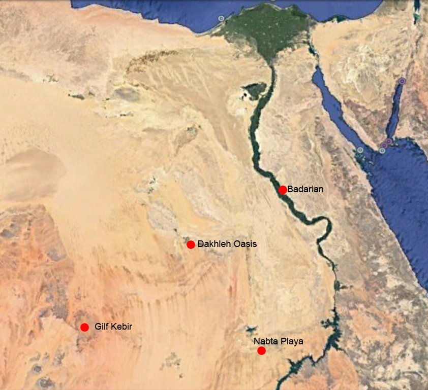 Figure 1.1 – The regions where the four case studies are based (Source: Google Earth)
The mid-Holocene presented both opportunities for groups and challenges to groups exploiting dryland livelihoods, and were characterized by seasonal uncertainty and longer term climatic fluctuation, which influenced the types of livelihood strategies that could be supported and the types of social complexity that emerged. Accordingly, the research questions have been formulated as follows:
Can a model derived from development economics describe and characterize mid-Holocene livelihoods in the eastern Sahara and elsewhere, in terms of risk, opportunity and sustainability allowing them to be directly compared and contrasted? Specifically:
- Can the chosen Sustainable Rural Livelihood (SRL) approach help to provide an understanding of dryland livelihoods in the east Sahara in the mid-Holocene, in order to improve the ability of archaeologists to handle vulnerabilities (risk and uncertainty) and opportunities in order to achieve sustainability?
- Can the SRL model help to standardize the collection and presentation of data
- Can ethnographic material help to interpret prehistoric socio-economic data captured in the SRL model, maximizing the value of the archaeological data?
- Can the SRL model help to improve the ability of archaeologists to compare and contrast the use of landscape?
- Can the model suggest new problem-orientated data collection priorities?
The Sustainable Rural Livelihood (SRL) approach provides both a descriptive matrix and an explanatory component which includes variables that can act on any given situation. Four case studies are described using the Sustainable Rural Livelihood framework developed for use in development economics. Thse are used to explore the relationships of different livelihood assets, influential variables and outputs. In its Guidance Sheets, the Department for International Development (DFID) has described the Sustainable Livelihood approach as follows (DFID 1999, p.1):
The sustainable livelihoods framework presents the main factors that affect people’s livelihoods, and typical relationships between these. It can be used in both planning new development activities and assessing the contribution to livelihood sustainability made by existing activities. In particular, the framework:
- provides a checklist of important issues and sketches out the way these link to each other;
- draws attention to core influences and processes; and
- emphasizes the multiple interactions between the various factors which affect livelihoods.
The framework is centred on people . . . . Its aim is to help stakeholders with different perspectives to engage in structured and coherent debate about the many factors that affect livelihoods, their relative importance and the way in which they interact.
This is conceptualized as a diagram that shows how different components and influences can be visualized, explored and analyzed. It has been modified here to reflect that it is being used to deal with prehistoric contexts before the development of modern organizations, formal institutions and government bodies (figure 1.2). This diagram is shown at full size in Chapter 2 (figure 2.12), where it is discussed in detail. The framework is intended to assist analysis for the purpose of managing complex data, not to constrain it: “The livelihoods framework is not intended to depict reality in any specific setting. It is, rather, intended as an analytical structure for coming to grips with the complexity of livelihoods” (Farrington et al 1999, p.3):
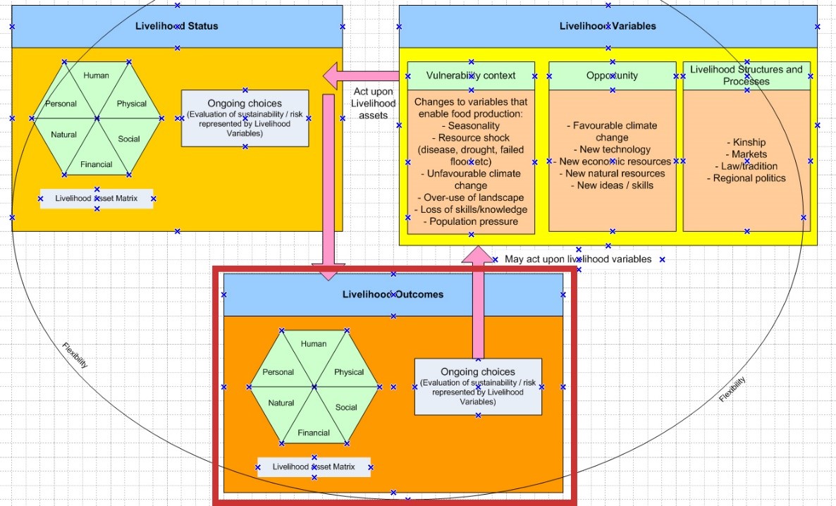 Figure 1.2 – The Sustainable Rural Livelihood Model
1.2 Hypotheses
1.1 Hypotheses
The research questions listed above have been formulated as six hypotheses. Joel Mokyr warns about making the hypotheses too inflexible to be tested reasonably, but not so flexible that they cannot be tested either usefully or at all (Mokyr 1983, p.1).
A – New approaches to modelling in archaeology, derived from approaches in development economics and created explicitly to analyze livelihood sustainability, can improve data capture and analysis in archaeology.
By applying techniques that look at the entire profile of a given community within a clearly defined framework, it should be possible to capture and characterize the full range and depth of its status and its potential for sustainability. As development economics needs to include data from both economic and social components of human life in order to assist and achieve sustainability, its focus is on achieving depth of understanding in all segments of a community’s life (DFID 1999). It is hoped that this approach will assist archaeologists to obtain maximum information from even minimal data.
It is expected that descriptive and analytical methods used in development economics can be used to help understand process in the past, and that these approaches, by focusing explicitly on sustainable livelihoods, provides an appropriate lens through which to view, understand and characterize the early food producing activities of prehistoric groups. The Sustainable Rural Livelihood approach, which includes both economic and social parameters as assets involved in livelihood management, should help to present a balanced view of all the factors which that influence behaviour.
B – The Sustainable Rural Livelihood (SRL) model provides a new way of bridging between ethnographic and archaeological data in a way that enables archaeologists to maximize the value of sometimes sparse data in marginal dryland environments.
The SRL model is a practical tool for gathering data, can also be used as a way of demonstrating the value of ethnographic data for informing archaeologists about processes in dryland environments by assembling ethnographic data in the SRL model prior to its use for archaeological data, thereby building an understanding of how ethnographic and archaeological data might correspond to one another.
C – The SRL Model improves comparative studies between contemporary sites by presenting data within the same formal framework of analysis.
The SRL model is a formal framework for capturing and describing data and identifying influences that might result in changes to sustainability (Carney 1998; DFID 1999; Morton and Meadows 2000). By capturing data within the clearly defined categories, it is possible to compare different sites or areas across all categories or within a specific set of categories. This enables different levels of complexity to be picked out and focused upon.
D – Variables involved in decision making and risk handling that may lead to changes in the archaeological record can be suggested by completing the SRL Model
Although Eastern Saharan data is not, in general, sufficiently robust to establish a direct relationship between possible influences on human activity and actual outcomes, the data can suggest why the archaeologically visible outcomes occurred. Decisions made under conditions of risk and uncertainty, and requirements for sustainability will be tested using data from the mid-Holocene eastern Sahara.
E – The SRL Model will help to clarify priorities for data collection
By insisting that all aspects of a community’s life are important to its sustainability, new approaches in development economics help to create complete pictures of a community’s status. In archaeology, similar gaps can be highlighted and, where possible, new strategies developed for looking at gaps in knowledge and how to address them can be identified.
F – The SRL Model can help to answer specific key questions about livelihood management systems
At the end of each case study the same eight key questions are asked of the data, and these are used to measure how successful the completion of the model was in the extraction of data from the published material. These questions are about livelihood management techniques, risk handling and sustainability.
Potential Problems
- It was identified at an early stage that the archaeological data might be too impoverished to fulfil the requirements of the SRL model, thereby presenting a risk to exploring hypotheses A – D. It was a concern that extrapolation from the data would make it either difficult or impossible to populate the SRL model in part (with an emphasis on data in any one category at the expense of any other) or in total (with insufficient data under any category). As one of the purposes of this approach is to provide a balanced way of presenting and using data to understand both economically rational and irrational variables influencing behaviour, failure to adequately complete the model in at least one of the case studies would represent a failure of the modelling approach used.
- With respect to E, although it was expected that research gaps would be identified, it was equally possible that they would not be.
1.2 Methodology
1.3.1 Process
In order to pull all the threads of the thesis together, which includes data drawn from archaeological research, ethnography, development economics, economic anthropology and quantitative analysis techniques, the following methodology has been used to assemble and present the required components. Only published material is used. The steps describe how the research has been assembled, shown as a schematic in figure 1.3:
- Selection of four regions with which to conduct the case studies
- Identification of and description of the modelling and theoretical systems that are to be used for descriptive and explanatory purposes (chapter 2)
- Familiarization with ethnographic material and development economic research into sustainable dryland economies (chapter 2; appendices C, D, E, F and H)
- Situation of the modelling techniques employed in the thesis within an archaeological theoretical framework (chapter 3)
- Familiarization with eastern Saharan archaeology
- Establishment of the climatic and environmental background to the mid-Holocene (chapter 4)
- Research into risk and uncertainty in dryland environments (chapters 4 and 5)
- Formulation of key questions for applying the SRL model to issues of risk, opportunity and sustainability (chapter 7, section 7.1.6)
- Creation of a template for data collection for the case studies (chapter 7)
- Application of the SRL Model to the data to the four areas (chapters 6, 7 and 8; case studies), supplemented by additional techniques as required (described in chapter 2)
- Comparative analysis of the four case study areas (chapter 9)
- Measurement of all findings against the hypotheses and presentation of final conclusions (chapter 10)
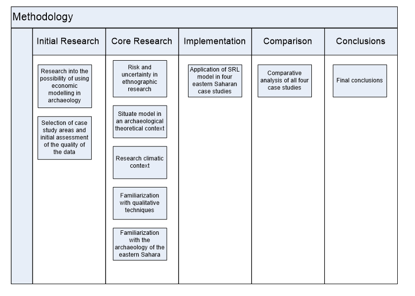 Figure 1.3 – Schematic showing the main stages in the completion of the thesis
1.3.2 Data Quality, Collection and Inference
1.3.2.1 Data Quality and Limitations
The SRL approach depends upon the availability of data for all asset components within the matrix. As stated in section 1.2 on page 20, a successful test of the case studies depends on sufficient data to be available in at least one of the case studies. In this section of the quality and limitations of the data are assessed.
In all of the case studies the quality of the archaeological data is very variable and often fragmentary due to natural and human processes (Butzer 1982, p.177-181; Kuper 2002; Schild and Wendorf 2012). In hyper-arid areas, due to the friability of sand and the impacts of wind erosion on lighter particles of sand and organic remains many occupation sites are heavily deflated and may be completely unstratified, surviving as palimpsests of mainly inorganic materials on a single modern surface (Garcea 1993). Organic remains rarely survive this process, leading to a depletion of zoological and botanical information, and much of the remaining objects may be heavily abraded (Fanning and Holdaway 2001; Shirai 2005a). It should be noted that even where stratigraphic information is available from sites, some of these are from a small number of small sample trenches cut through much larger sites, and therefore provide a potentially biased sample, presenting only part of the complete story (Hodder 1999, p.52-3; Lucas 2001, p.60-61; Lucas 2012, p.63-66; Trigger 1996, p.402). Even in the case of the Badarian sites, the lack of stratigraphy and the failure to establish a typological sequence means that it too must be treated as a palimpsest. This is discussed furher in Chapter 6, “Introduction to the Case Studies.” Modern techniques have been applied to most of the areas, but in the cases of both Gilf Kebir and the Badarian excavations the quality of the excavation techniques from the 1920s to 1950s (Bagnold et al 1939; Brunton and Caton-Thompson 1928; Brunton 1937, 1948; Rhotert 1952), was inferior to those of today, as discussed below.
Rock art data is included in the Gilf Kebir case study, because modern excavations and analysis have provided convincing indications of different phases of rock art themes correlating with palaeozoological data and dated archaeological remains (Kuper 2013; Honoré 2017; Zboray 2009, 2013). However, rock art in Dakhleh Oasis is not included as a dataset due to problems correlating rock art and archaeological phases. Although it is considered to be broadly “Neolithic,” (Polkowski et al 2013) this includes early and late Bashendi A, Bashendi B and Sheikh Muftah periods, which is not sufficiently specific to be of use as a dataset for the Bashendi B.
In the cases of the Gilf Kebir, Nabta Playa and Dakhleh Oasis, modern field work have ensured that data is captured using modern sureys, excavations and sampling techniques. Publication has, however, been variable.
At Nabta, because the site is in the desert it did not suffer from agricultural or other forms of development, but sites and artefacts have suffered deflation, erosion and abrasion. Poor preservation has favoured inorganic remains, particularly lithics (e.g. figure 6.4) and deflation at the site led to the preferential survival of the bones from medium-sized and larger animals and poor preservation of plant remains. Gautier (2001) notes that sampling of archaeozoological remains at both Nabta has been problematic because a) sample sizes have differed due to alternative sampling strategies and b) samples sent away for analysis were often selected by non-specialists and c) field identifications that were made by specialists were carried out without comparative data that would have been available under lab conditions (Gautier 2001, p.610). Storage inadequacies and failure of remote specialists to return samples aggravated the situation. Looting from the site has been a problem. This was magnified after the publication of a book that interpreted the site in terms of star maps dating to 16,500-17,500BC (Brophy 2002) and generated a lot of unwanted interest in Nabta from New Age enthusiasts (Schild and Wendorf 2012; Wendorf and Schild 2015). Souvenir hunters visit the site and do it considerable harm by denuding the site of artefacts, moving stone slabs from one site to another and rearranging both objects and sites, particularly the stones of the stone circle (Schild and Wendorf 2012, p.429). The stone circle and other key components have therefore been moved to the Nubia Museum in Aswan, where they are a permanent outdoor installation (Wendorf and Schild 2015). Regarding publication, two volumes were produced. The first volume (Wendorf, Schild et al 2001) described fieldwork in detail, but information was not standardized from one paper to the next so much of the information about technologies (e.g. core types and numbers, debitage and artefact types) are not directly comparable from one site to the next. In addition, it prioritized the Early Neolithic rather than the Late Neolithic. In the second volume (Nelson et al 2002) the ceramics are discussed, but there are inconsistencies in the tabulation of the data presented in the text, discussed further in Chapter 8, the Nabta Playa case study.
Most of the sites are in areas that are now desert around the edges of the modern oasis. Some are undoubtedly under cultivated land, as is the case in the Nile valley. Because they are essentially desert sites, they are often in highly deflated condition, but as well as the usual inorganic remains, some organic remains have been found including bones, pollen and macrofossils and radiocarbon dates are available from numerous sites (McDonald 2016, p.182).
Some of the results of the strands of research by the Dakhleh Oasis Project have been presented at a four-yearly conference and are published as interim reports in the Dakhleh Oasis Papers monographs and in papers scattered through various journals and edited volumes, detailed in Chapter 6. A volume dedicated to the ceramics of Dakhleh in 2018, was produced in 2018 (Warfe 2018). No equivalent exists for the lithic technology, and no detailed data has been published on core and debitage types, so there are some significant differences in the availability of the data between this and the other case studies. So far there is no single overview of the prehistory of Dakhleh The research by Woods (2016) into religion and ritual in the prehistory of the Western Desert includes Dakhleh but is exclusive to undated rock art and is not incorporated into the case study. There have been no reports of tourist activity that has afflicted the Gilf Kebir and Nabta.
In the Gilf Kebir tourism has been a problem (Kuper 2002). Although it is in one of the most remote areas of Egypt, Wadi Sura I in the Gilf Kebir (Almasy 1939; Kelly 2002), became enshrined in the 1996 film “The English Patient” as The Cave of Swimmers. Just before the 2011 revolution in Egypt over 2000 visitors a year took trips to the site and, in the process, collected artefacts as souvenirs from the desert surface, damaging the prehistoric surfaces in four-wheel drives and inflicting damage on the rock art by touching, wetting and tracing it (Honoré 2017, p.7; Kuper 2007a, p.24; Kuper 2002b, p.118-21). Nabta Playa is a short drive from the main road leading to the major tourist destination at Abu Simbel, and has suffered a similar fate, with the added indignity of being targeted by New Age enthusiasts who have routinely rearranged objects and monuments (Schild and Wendorf 2012). Some of the most important monuments have now been located to the Nubian museum in Aswan to protect them (Schild and Wendorf 2015). The main publication of the Gilf Kebir (Linstädter 2005a), largely written in German, prioritizes the Gilf B rather than the Gilf C. There has been no central publication of the Dakhleh Oasis information, so the data is scattered through various publications and re-uses the same core images. Very little information is available in tabulated form about the technologies employed, meaning that very little extrapolation is possible from the data presented. In addition, the earlier Masara periods are priveledged in the publications.
On a positive note, in each case sufficient archaeological material survives to enable experimental assessments to be made of the livelihood strategy of each group under consideration, and in each area there is sufficient climatic and environmental data to attempt to reconstruct natural contexts in which livelihoods were practiced.
The Badarian excavations ran over three seasons, 1922-3, 1923-4, and 1924-5 (Brunton 1929; Brunton 1929b; Brunton 1937; Brunton 1948; Brunton and Caton-Thompson 1928). Excavation standards were advanced for the period, but the publications were by no means as detailed as modern reports. At Badari, Mostagedda and Matmar, Brunton excavated both cemeteries and settlements, but focused attention on the cemetery sites (Brunton and Caton-Thompson 1928; Brunton 1937 and 1948). He cleared whole sites rather than sampling them, meaning that there was little left to explore later. Caton-Thompson describes how in the 1923-24 season he had 300 workmen “methodologically working the screes northwards to Badari” (Caton-Thompson and Whittle 1975, p.90). He made no plans of sections and no stratigraphic features were noted. Only a few of the burials were published as plans. Much of the organic material excavated was so fragile that it could not be preserved, and Brunton commented at Mostagedda, when talking about the difficulties of excavating matting, that the team’s “botanical knowledge was insufficient to describe it accurately in the field” (1937, p.47). Similarly, no experts on site were available to analyze the human remains. The excavations at Mostagedda in two seasons in 1927/28 to 1928/29 and Matmar in another two season in 1929/30 and 1930/31 were both published many years after the excavations were carried out in 1937 and 1948 respectively and far more briefly than the Badari excavations. The collection strategy at settlement sites favoured only the most diagnostic pieces of stone tool technology and ceramics, to the detriment of debitage (Caton-Thompson and Whittle 1975, p.90; Holmes 1989a, 1989b; Friedman 1994, p.304-7). Tomb robbing was extensive at the cemetery sites (Brunton 1929, p.458). Sites were also disturbed by later re-use, particularly in the Old Kingdom and Roman periods. In all his publications Brunton indicates where sites were disturbed and undisturbed (Brunton 1937, 1948; Brunton and Caton-Thompson 1928). Caton-Thompson, looking for a stratified settlement site, confined her activities to Hemamiyeh North Spur (Brunton and Caton-Thompson 1928, chapter V). She divided the site into strips 35ft long by 10ft wide, which were then divided into 5-foot squares, and each artefact was located to the nearest foot and precise depth, and she undertook sieving at the site. The excavation established that the Badarian predated the Naqada I period, but the fixed 6-inch levels did not correspond to the actual stratigraphy of a sloping site with varying levels of stratigraphic thickness, meaning that it has proved to be impossible to tie the different parts of the site together in a stratigraphic sequence. The only secure internal distinction observed is a natural formation that Caton-Thompson calls breccia, found 6 and a half feet below the surface, which seals largely undisturbed deposits below and has deposits that overlie it. Other Badarian levels over the top lie between 6ft and 4ft 6 inches and above that, to a level of 3ft 6 inches, was a Badarian / Naqada I transition layer. Caton-Thompson never had the chance to give a full account of the excavation, on the one hand due to restrictions imposed by publication costs which prevented her from discussing the sections and inventory in detail and publishing a separate publication on flint implements; and on the other by the destruction of all her field notes, unpublished sections and photographs during the London Blitz in 1940 (Caton-Thompson and Whittle 1975, p.89). The review of Badarian lithics in museums by Diane Holmes (1989a) demonstrates highly selective object collection practices, focusing on distinctive artefacts at the expensive of less distinctive flakes and debitage, meaning that modern analysis of the lithic assemblage is confined to only a biased sample of the full lithic dataset preserved in museum collections. The excavated material from the Brunton and Caton-Thompson excavations was divided between twenty eight different museum collections, a practice consistent with the conventions of the day. The largest single accessible collection is in the Petrie Museum of Egyptian Archaeology at UCL, London. Publication of the Badarian (Brunton and Caton-Thompson 1928; Brunton 1937, 1948) was impressive in its day, but complete records of all sites were not published, and modern analysis focusing on museum collections has been important but has not been drawn together in a modern interpretative synthesis.
Poor quality data is unavoidable in the eastern Sahara. Variability in the quality of the data obviously presents potential problems for any approach attempting to assess all aspects of a livelihood. Palimpsests (defined in Appendix A) and items in museum collections that are only loosely provenanced can provide a particular challenge for archaeologists. Approaches to such problematic datasets clearly require the development of consistent methodologies that produce archaeological interpretations that are generally considered to be archaeologically viable. This is a matter continues to be discussed but has not yet been resolved (e.g. Allen 1991; Bailey 2007, 2008; Bradley, P. 1998b; Daubney 2015; Foley 1981a, 1981b; Fanning and Holdaway 2001; Gordon 2006; Hey 1999; Historic England 2012; Holmes 1989; Lisk et al 1998; Lucas 2005; Schofield 1995; Snashall 2002; Vallverdú et al 2005; Vaquero 2008; Vaquero and Pastó 2001; Witmore 2009). Approaches to palimpsests and museum collections would develop from the development of standardized methodologies for collection and analysis in the future. A standardized approach to palimpsests, at least in the eastern Sahara, might help to maximize the value of such data, and discussion at conference level about how this might be handled could improve the analytical potential of palimpsests and the value of the output of such archaeological endevours.
Even the simplest of the models contemplated for analysis of the four areas selected require information in a number of social, ecological and economic dimensions. However, the SRL model itself helps to tackle the issue of poor quality data by making it a requirement that surviving material is queried in different ways depending upon the problem it is being asked to address. By requiring the completion of the model down to the everyday details of livelihoods, the information available from the surviving material remains can be used to propose a range of possibilities. For example, bifacial lithic tools may answer a range of questions about economic activities, industrial production, trade and social relationships and symbolic expression. However, where the data cannot be used to complete the model in certain areas, this is made explicit, and in the hands of a fieldwork project could be used to suggest future directions for field research.
One of the approaches taken here has been to take often reductive statements about what data represents in social terms and explore a range of other possibilities for the same data. An example from this thesis is taking the suggestion by Gillian Woods that much of the Late Neolithic ceremonial centre at Nabta can be explained by reference to shamanism, and proposing other solutions that fit the data. This produces a series of alternative outcomes rather than a definitive explanation that merit either 1) further analysis of the raw data with a view to narrowing down a plausible interpretation, 2) more excavation where possible or 3) an admission that the data cannot provide sufficient confidence in any one answer, but instead requires a more holistic approach.
In all of the case studies, where published archaeological material has not been not sufficient to extrapolate in a direct and empirical way, ethnographic research has been used to supplement archaeological data to approach questions about livelihood risks and opportunities. Whilst ethnographic information cannot substitute for archaeological data, it can help with the task of extrapolating from the archaeological remains to the livelihoods they represented. Chapter 5, “The Vulnerability Context,” describes modern livelihood strategies practiced under conditions of risk and uncertainty, and this body of research has been used to suggest potential livelihood strategies that would have been available to pastorlists in the environmental conditions prevalent during the mid Holocene in the eastern Sahara. The use of ethnographic data in the thesis is discussed in this chapter in 1.5.2.
1.3.2.3 Publication
It has recently been pointed out (Berggren and Hodder 2003; Hurcombe 2014, p.152; Lucas 2001, p.105; Redford 2008, p.23; Weeks 2008, p.21; Whittle 2003, p.82-3) that excavation reports continue to emphasize the division of excavated remains into chronological and analytical divisions of materials assembled by separate specialists, rather than providing an integrated understanding of sites as living societies. The standard approach of the excavation report allows data to be divided into clearly delineated segments that can be reconsidered by future analysts. However, the dangers are that some object types are prioritized over others (Lucas 2001, p.79); that specialist reports are often not incorporated seamlessly into the final consolidated report but find themselves relegated to appendices that list and tabulate features (Connah 2010, p.137); that new digital methods of recording are associated with “further systematization of work in large-scale projects and further codification may take the excavations further from the process of interpretation (Berggren and Hodder 2003, p.57); and that a filtering process on what is or is not deemed of value to include includes a bias in what is made available (Buccatelli 1998). As Hurcombe (2014, p.152) states: “although artefacts are studied by archaeologists in categories that are defined by materials . . . that is not how they existed in life . . . . This whole material culture was bound with people’s ideas, identities and beliefs.” Although, As Gosden points out (2010, p.110) archaeology may find it difficult at times to match Geertz’s “thick description” (Geertz 1973), it does have the opportunity to build on its data to provide narratives that are richer than those sometimes produced in archaeological monographs. It was hoped that the Sustainable Rural Livelihood approach would help to tackle the fragmented way in which past societies are often reported in excavation monographs, where specialist reports divide up the remains of past societies in a way that is convenient to archaeologists but often fails to represent life as it was lived. An example that comes to mind because I worked at the site is the first full report on the Middle Palaeolithic Pontnewydd Cave in North Wales (Green 1984), which consists of a series of technical reports unconnected by any form of interpretation. Another is the much-needed analysis of ceramics from Dakhleh Oasis (Warfe 2018), which is confined to a technical analysis and makes no attempt to place ceramics into the wider context of livelihoods in the oasis. This type of report is, however, the essential foundation for interpretative work (Redford 2008, p.23; Weeks 2008, p.21). These and other archaeological publication issues are discussed at length by Jones et al 2003. The SRL matrix also divides and subdivides societies and livelihoods (DFID 1999) but does so in a way that promotes discussion of those livelihoods within a framework that is equipped to incorporate data as a unit of analysis and interpretation. Particularly, it positions assembled data in the context of a number of dynamic variables that may act upon that data to transform it. The SRL Approach is a reflexive approach that is potentially subject to later modification as new data is secured.
1.3.2.4 Qualitative Approaches
Qualitative approaches explicity acknowledge the dynamic character of society and recognize that interpretation is not a replication of data but an interpretation of that data, for which multiple narratives may be created. It has a transparency that allows research to be communicated to non-specialists and allows the researcher to examine how meanings are formed within cultures (Corbin and Strauss 2008). The merits of qualitative and quantitative approaches are discussed in Chapter 3 “Situating the SRL model within archaeological theoretical approaches”, section 3.5, but here it should be noted that in order for qualitative approaches to result in explanations that carry a level of confidence, detailed description is needed, to establish a strong foundation for the explanatory approaches (Corbin and Strauss 2008, p.15). The case studies therefore include a large descriptive component.
1.4 The Sustainable Rural Livelihood Model
The Sustainable Rural Livelihood (SRL) model is discussed in detail in Chapter 2. It derives from applied theoretical approaches but sits squarely between theoretical and methodological approaches. The thesis takes data from published reports, removes it from the categories in which it is usually framed in analytical divisions imposed by field and post-excavation specialists. Instead, the data is placed into a descriptive, interpretative and explanatory framework designed to reflect the livelihoods and livelihood options that are suggested by the excavated remains. The SRL approach (Carney 1999; DFID 1999; Hamilton-Peach and Townsley 2004, 2007) therefore places data presentation into an explicitly interpretative framework that lends itself to explanatory approaches and to comparative studies between different sites and areas. The SRL approach is supported, when required, by other techniques for further understanding livelihoods and their specific characteristics. The SRL approach demands a highly formal approach to data collection (DFID 1999) but provides individual researchers with flexibility about how that data is explored. In development economics it is used to create social and economic profiles in order to suggest solutions for securing sustainability in the future (Morton and Meadows 2000). In archaeology it would be most likely to form the basis of a comprehensive exploration of an excavated site, series of sites or an entire landscape.
The use of a modelling approach based explicitly on development economics, which is, as far as I know, new to archaeology is intended to represent a new way of handling existing data with a view to extracting a more complete understanding of livelihoods. This is consistent with geologist Chamberlain’s approach of the late 1800s (Chamberlain 1890), also discussed Trigger (1995, p.456). Chamberlain focused on improving methods in areas where knowledge exists but much remains to be known. He describes the Euclidian approach of studying of a problem by close imitation of previous thinkers with an approach that he describes as “creative study” (Chamberlain 1890 p.754). He argues that “it is not necessary that the subject-material should be new; but the process of thought and its results must be individual and independent, not the mere following of previous lines of thought ending in predetermined results” (1890 p.754).
A possible objection to the use of the SRL model is that it is designed to represent societies in the present rather than in the past and that simply lifting it and that applying it to prehistoric contexts might not be straight forward. When I tested the model against a modern ethnographic society (Appendix H) there were no problems. However, this was not the case when I began to look at the asset matrix and the variables that might act upon it during the case studies.
The asset matrix that defines the Livelihood Status is very dependent upon the archaeological material available for each of the components (natural, subsistence, social, human, physical and personal). Where the gaps were substantial, this was dealt with by making these gaps explicit and not attempting to extrapolate from limited data. Where archaeological material was found to be sufficient, interpretations of the data were attempted, and in some cases the limitations and potential of the model were tested by pushing the data to its limits for the purposes by proposing a number of different possible interpretations for the same data. Of all the asset components, the “personal” category was the most difficult to fulfil, due to its somewhat nebulous character in non-complex societies, but archaeological measures for handling it in prehistoric contexts are proposed in Appendix G.
The variables that acted upon these assets in the Livelihood Variables described in the original SRL model (figure 2.9) were more clearly inappropriate. To test the SRL model in prehistoric contexts, it had to be modified. Whilst the Vulnerability Context required no changes, the Livelihood Structures and Processes were focused on national government, laws, policies and private sector intervention, and there was no explicit section for the role of opportunity. Livelihood Structures and Processes were therefore modified to encompass variables that would have acted on communities in prehistory (figure 2.12). A separate category to capture the importance of opportunity was added.
The output of the model and supporting models is subjective. It was hoped that data in publications would be available for the application of statistical measures, but although this proved not to be the case, even had this been possible such findings would still have been fitted in to a subjective framework, where interpretation and explanation are based on variable archaeological material that does not lend itself to purely empirical approaches. There is further discussion of some of the merits of qualitative versus quantitative approaches, including computer simulation modelling, in Chapter 3 (section 3.4), but here I wish to emphasize that this approach shares many of the benefits of ethnographic approaches to modern communities, in that it can answer open questions and incorporate multiple interpretations of data in order
1.5 Ethnographic Analogy
1.5.1 Understanding ethnographic approaches
Ethnographic data is defined here as information recorded by modern and historical observers who have spent time researching ethnographic groups operating livelihoods that may be partially analogous to those in prehistory. Ethnographic analogies have been used in two principal guises: direct analogy and more holistic and indirect approaches (Orme 1981; Trigger 1996). Direct approaches, often referred to as ethnoarchaeology, examine material patterning and uses these to create analogies for archaeological contexts (Lucas 2001, p.180). However, as Wylie says (1985, p.63) the influence on archaeology of ethnographic analogy “has long been an object of uneasy mistrust among archaeologists” and concerns have been frequently expressed about the archaeological use of ethnographic data (e.g. Agorsah 1990; Ascher 1961; Bernbeck 2008; Clarke 1978, chapter 9; David and Kramer 2001; Hodder 1982c, 1990; Orme 1981; Rosen 2008; Shaw 1989a; Wylie 1985; Wengrow 2001, p.91-104; Wobst 1978, 2006).
In the 1970s and early 1980s the debates of the “New Archaeology” put ethnographic analogy at centre stage. Binford (1981) suggested that if behaviours in the present produced similar deposits to material remains left in the ground in the past they could be used as bridges to an understanding of past human behaviours. His aim was to clarify the technical end of archaeology, looking at manufacturing, use and deposition. In this it was functional and its wider emphasis was on looking for adaptive practices within ecological frameworks. It was only later that the scope of ethnographic analogy was expanded to look at socially-derived aspects of human life. Shanks and Tilley (1987), amongst others, were concerned that “behavioural correlates” between archaeological and ethnographic materials and practices were both deterministic and of dubious value. Lane (2006) observes that research using ethnographic data to assist with explanations of depositional data has been better received than symbolic and structural studies, and that all methods have been used more in Europe than in Africa (the latter point also made by Agorsah 1990). More holistic approaches looked for an improved understanding of archaeological theories of material culture (Hodder 1982c, p.212). These approaches developed an understanding of objects as they operate within society and act upon it, rather than taking the narrower view of objects as things produced by society (Gosden 2010, p.114).
One of the most damaging criticisms is that ethnographic samples normalize important variation, leading to system-wide general explanations that take out granularity and paint misleadingly homogenous pictures that are simplistic and reductionist (Borić 2005; Cordell and Plogg 1979; Hodder 1982c; Jochim 1991; Wobst 1978). Leach (1973), a structural anthropologist, was particularly eloquent in his rejection of archaeology’s search for universal laws of behaviour, on the basis of his observations of extreme variability of behaviours in his own field, and he argued forcefully against direct analogy between modern and prehistoric groups. Responding to processual archaeology’s use of ethnographic data in generalizing theories of human existence, Ian Hodder’s research with ethnographic groups in sub-Saharan Africa emphasised the heterogeneous character of the groups he studied and, at the same time, presented a serious challenge to the idea that material remains always reflected cultural ideas because sometimes they were sometimes used in processes of concealment and transformation (Hodder 1982c). Agorsah is similarly damning: “It is becoming quite clear that mere accumulation of ethnographic data and the provision of half-baked generalization with the usual cautionary note ‘more needs to be done on the subject’ are in effect obstructing the development of the type of researching ethnoarchaeology that would contribute viable theoretical formulations” (Agorsah 1990, p.190). David and Kramer remind archaeologists that human behaviour cannot be determined by social norms because individual people do not always conform to social rules, and may be transformed by processes that cannot be captured by ethnographic generalization (David and Kramer 2006, p.35).
Questions of temporal scale frequently arise as a major dilemma facing archaeologists who wish to make use of ethnographic data. Although people living in the past and living in the present may have lived their lives at similar temporal resolution, the datasets used by the researchers in the different fields offer a different type of temporal resolution (Jochim 1991, p.315; Lucas 2010). In the early 1950s Clark (1951) observed that archaeological and ethnographic records represent different temporal scales and phenomena and are therefore mismatched, a point made by other writers including Binford (1986) and Bailey (1981). Rates of change may be similar but it is our ability to observe them that differs. As Binford puts it: “the observations by ethnographers and historical figures, whilst perhaps documenting something of the internal dynamics of cultural systems, cannot be expected to be necessarily germane to an understanding of a much slower and larger-scale process of change and modification” (1986, p.27). Wobst is concerned that when ethnographic data is applied to palimpsests, it is marrying different scales of living because ethnographic data represents daily living whereas palimpsests represent much longer periods of time, sometimes several distinct episodes and sometimes centuries of living (Wobst 2006). A similar point is made by Rosen (2008, p.115) who says that an understanding of pastoralists from short-term ethnographic data has inhibited an understanding of pastoralists in the longue durée. Leach (1973b) warned that too many archaeologists are tempted to use ethnography as “fossilized survivals” (p.761). Phillipson worries that scholars without a background in Africa have a view of African history that is “still all too often expressed in terms of a timeless, almost mythical, status quo which ignores the major economic and social changes that have taken place in many parts of Africa during recent decades (1989, p.1). David and Kramer refer to this sense of timelessness as “the ethnographic present” and question its ability to cast light on processes that make up the material recorded over any time spans except those that are very short (2006, p.50). Lucas (2010, p.34) suggests that “rather than inferring dynamic events from static things, archaeology can explore the latent forces that bind things into material assemblages or collectives,” a distinction between latent and manifest agency. Rosen (2008) looks further at the idea of fossilization, again highlighting the problem of using ethnographic records as snapshots in time, which are then applied to the longue durée but also points out that ethnographic analogy discourages archaeologists from seeing variations in pastoral schemes that are beyond familiar analogies, the latter point also made by Wobst (1978) and Hurcombe (2014, p.5-6) who suggest that there may have been many practices in prehistory that are simply no longer carried out today. This can be illustrated by the production and use of Clayton Rings at the end of the mid-Holocene in Egypt and Nubia, items that are no longer made today and for which no convincing function has so far been suggested (Riemer 2004b; Kuper 2007c, p.25).
Another concern is that there are no examples of incipient pastoralism in modern contexts, where pastoralists practice independent herding without recourse to agricultural produce (McCorriston et al 2012, p.46), although there are examples of incipient cultivation. Each example of pastoralist activity is well developed, having evolved usually over centuries. Even in examples where many pastoralists are now adopting cultivars for the first time, most groups have been familiar with cultivators for a long time and in many cases have been dependent on exchange with cultivators for a supply of grain. This means that early experiments combining hunting, herding, fishing and foraging are not represented in the modern ethnographic record and analogies are therefore not available. A related concern is that most ethnographic groups have been heavily influenced by colonial activities and today are influenced by pressure put on them by modern economic conditions, both of which make direct and rational analogy impossible. This point has been made by a large number of writers (e.g. Grove 1978; Kinahan 2004, p.157; Rosen 2008, p.117; Silberbauer 1981; Stahl 1993; Wengrow 2006, p. 10; Wobst 1978).
Geographical correlation is another issue. Linguistic studies have been used to suggest that some of today’s Saharan groups may be the direct descendants of prehistoric African populations (e.g. Cavalli-Sforza et al 1994, p.172-3), and there have been some suggestions (Clark 1952, p.3; Smith A.B. 1984, 2005a, p.43) that this gives them particular relevance in terms of understanding the use of specific topography and landscapes shared by both past and present groups. Such inferences are highly questionable given the time gap between prehistoric and modern groups and the many influences that have impacted them in the intervening time.
Specific approaches have been suggested to mitigate the problems. For example, Ucko (1969, p.262) recommends that archaeologists avoid direct analogy but instead use ethnographic data to improve understanding of livelihoods before attempting to interpret it in prehistory. Wengrow believes that the strength of anthropological research for answering archaeological questions depends to a great extent on the similarity between the questions “that each has asked of their respective material, and upon the quality of the answers they have provided” (Wengrow 2001, p.92). Yellen (1997, p.12) argues that general analogies should be stated in the form of hypotheses which may then be tested, an approach supported by Wobst (1978) and David and Kramer (2006, p.48). Agorsah (1990, p.195-6) also emphasises the importance of using a clearly defined procedure for the use of ethnographic data in archaeology: “Ethnoarchaeology in Africa should embark upon a more systematic definition of the interface between modes drawn from human behaviour and those drawn from prehistoric societies,” p.203.
Hofman looks forward to an archaeological world where “as we learn to read the archaeological record more effectively, we should be able to learn about a past, or pasts, which are not limited by our own knowledge of the present” (1994, p.342). However, it is difficult to envisage an archaeology of prehistoric subsistence and society without analogy, and many archaeological writers, however conflicted about the problems of using ethnographic data, find its benefits to be worth discussing with a view to establishing workable methodologies (Atherton 1983; David and Kramer 2006; Orme 1981; Wobst 1978; Wylie 1985; Yellen 1997). In spite of the difficulties, the skilled analyses of modern groups and their problems offers the potential of assisting with the task of connecting some of the archaeological dots (e.g. Hodder 1982b; Trigger 1995; Veth 2005; Wendrich and Barnard 2008).
1.5.2. How ethnographic data is used in this thesis
Data capture of a modern ethnographic society, such as that of the Hadendowa that formed my first test case study (summarized in Appendix H) showed not only what could be captured in the SRL asset matrix, but what sort of information would be needed from archaeological contexts to achieve a similar level of resolution. This again focused attention on the potential problem of data quality, as highlighted in Chapter 1, section 1.2, and Chapter 1, section 1.3.2.1. It was immediately obvious that given the poor survival of organic remains in the archaeological datasets, certain aspects of food production and trade in foods and craft items made of organic materials would be difficult to capture. Similarly, religious beliefs that can be observed in person during ethnographic interviews are lost in the archaeological record.
To address this, and mindful of the concerns about ethnographic analogy raised above, my general objective was not to draw highly specific ethnographic analogies to explain individual assemblages of archaeological data but to aim for a much broader heuristic evaluation of the range of possibilities and responses that might take place. This is a holistic and inductive approach that does not make exact analogies between past and present but uses ethnographic data as a tool with which to assess the relationship between livelihoods and the opportunities and constraints that may act upon them. As far as possible, I have limited myself to groups that share the same types of environmental constraints to those in the past. Information derived from the present is used as a guide, not a precise analogue, to the possibilities for human action under certain conditions where similar constraints and opportunities may have existed. It has not been used to understand particular artefacts or artefact distribution or to project precise situations into the past in a deterministic fashion. More specifically, ethnographic data has been used to help complete the SRL model in three ways.
First, in order to suggest explanations for some of the outcomes visible in the archaeological record ethnographic data is used to understand the most likely responses to dryland environments with a view to better understanding prehistoric societies, particularly with respect to their handling of risk and uncertainty. Peter Ucko’s recommendation that archaeologists use ethnographic data to “widen the horizons of the interpreter” (1969, p.262) informed how ethnographic data was used in this thesis. The outcome of this research is captured in detail in Chapter 5 where modern techniques for handling risk and uncertainty are listed and described to use as a took for extrapolating from archaeological data to suggestions for livelihood stragegies. This informed much of the work in the case studies and in Chapter 9, “Comparative Findings.”
Second, ethnographic data has assisted with the completion of the asset matrix in suggesting where analogues were not going to be available. Anthropologists have the ability to observe and interview their subjects, whereas in archaeology analogues and proxies for certain behaviours need to be found in the archaeological record and methods for interpreting it. This led to the development of the “Potential Archeological Indicators” listed in Appendix G that might be used for completing the SRL model. It also lead to additional research into concepts like land tenure, boundaries, power and religion, concepts that are fundamental to the livelihoods of modern subsistence communities but which are very difficult to identify archaeologically.
Third, the knowledge used to complete the evaluations in the Livelihood Variables and Key Questions in the case studies and in Chapter 9, “Comparative Findings and Future Research” was largely based on the research into comparable ethnographic communities, some of which is captured in Chapter 5, “The Vulnerability Context: Risk and Uncertainty in Dryland Environments,” Appendix C “Milk and Lactose Intolerance,” Appendix D “Opportunity and Resistance to Change,” Appendix F “Comparative Values of Livestock,” and Appendix H “Test Case Study: The Hadendowa of Beja”.
Fourth, research into the specifics of livelihoods of specific groups like the Hadendowa, the Ma’aza, the Himba, the Hadendowa, the Tonga, the Dinka, the Wodaabe and the Barabaig, to name only some of the ethnographic populations mentioned in the text, whilst providing an understanding of many of the activities carried out and decisions made, were also useful warnings against coming to firm conclusions about livelihood patterns based on material remains alone. This meant that although ethnographic information informed this research, it was not used to extrapolate directly from material remains to simple explanations. Rather, it offered a basis from which to discuss a number of possible explanations.
Finally, it was also clear that the inclusion of government, N.G.O and global markets as impacts on local communities would need to be replaced in the SRL model with external impacts relevant to subsistence economies.
1.6 The Case Studies
1.6.1 Introduction to the Case Studies
As already discussed, settlement structures in the eastern Sahara are rare, although not completely absent. Similarly, funerary remains are by no means common. By far the greatest source of information is from heavily deflated palimpsests. Where possible a mixture of types of sites has therefore been used in this thesis to represent different types of deposition that are found in the eastern Sahara. All of the areas under discussion are dryland environments, each with a different type of water supply. The four areas modelled are 1) the Ru’at el-Baqar phase of Nabta Playa (5400-4500 cal. BC), 2) Dakhleh Oasis (Bashendi B 5300-4000 cal. BC), 3) Gilf Kebir (Gilf C 4500-3500 cal. BC), and 4) Badari (4400-3800 cal. BC). Each is described briefly in the Literature Review, section 1.6 and in detail in Chapter 6, the introduction to the Case Studies, as well as in the case studies themselves.
The unit size being modelled is that of a “group,” which is defined as a set of households. The term is deliberately flexible to reflect the potentially fluid nature of group membership (Crumley 1995, p.4; Gatto 2009, p.127; Schareika 2003, p.2; Wengrow and Graeber 2015). The sites were selected not on the basis of precise contemporaneity but on the basis of similarity of the food production preferences at each place. As the objective is to compare similar livelihoods, this emphasis seems both viable and sensible.
The Nabta, Gilf Kebir and Dakhleh areas are all desert locations with access to water on a seasonal basis. The Badarian sites, with access to river water on a year-round basis and floodwater on a seasonal basis (Brunton and Caton-Thompson 1928; Brunton 1929a, 1937, 1948) have been added to provide a different type of hydrological perspective to the other three areas. Other areas were considered, including the Faiyum, Farafra and Djara, all of which have been well recorded and are currently part of major fieldwork projects. However, all three are part of a northern Egyptian technological and economic tradition (Riemer et al 2013) whereas the Badarian is associated with a cultural output that, like Nabta and the Gilf Kebir shares elements the the Sudanese Nile, whilst Dakhleh sits at the interface between north and south, which makes them directly comparable when discussing concepts like social and economic interactions and technological traditions. More importantly, the Badarian provides a useful contrast to the more explicitly dryland sites above, and was chosen to provide an example of how the SRL model can be used to compare and contrast areas with different environmental backgrounds and economic foundations and with richer cultural output. Literature Reviews in section 1.6 provide an overview of each of the areas used in the case studies.
Table 1.1 shows a chronological framework of the main archaeological units mentioned in the text.
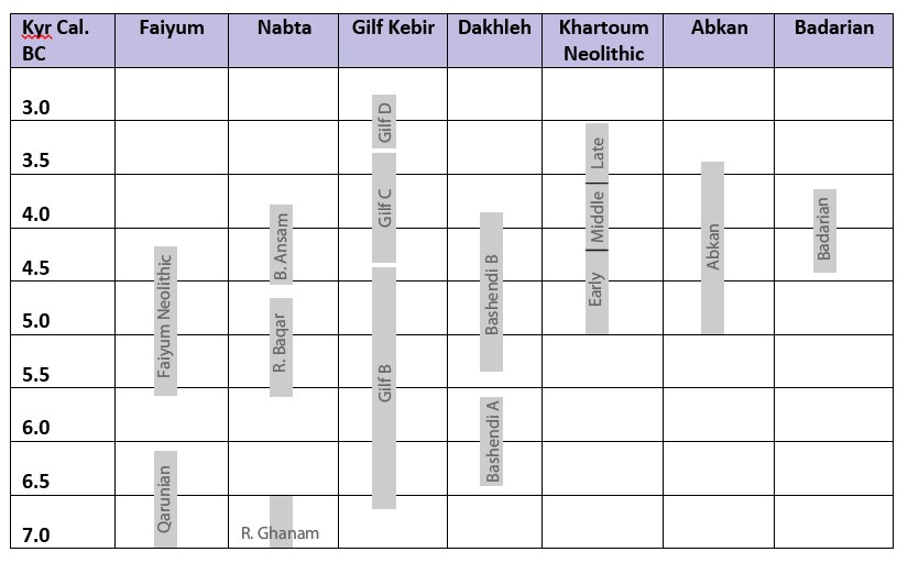 Table 1.1 – Chronology of the main archaeological units mentioned in the text
1.6.2 Comparative criteria
Comparative research has its own methodologies (Bollig 2006; Dennell 1977; Salzman 1971; Schweizer 1998). As Bollig emphasizes, “Only comparative research designs lead to valid explanations beyond the single case. Furthermore, comparative research leads to a broader understanding of options and limitations within a specific type of society” (Bollig 2006, p.16). Salzman (1971) emphasizes the need for a methodology for comparative studies, in which questions are clearly expressed, the focus of the comparison is explained and the variables to be compared are defined. To begin with, the areas themselves need to be comparable. Each case study offers opportunities for exploring localized responses to different conditions, which are compared in Chapter 9. The headings in the SRL template, described in Chapter 7, form the basis of the comparison and a set of “key questions” has been developed for comparative purposes, described in Chapter 7. All four case studies have been, and continue to be subject to professional archaeological and geological research, and all of the sites under discussion continue to offer potential information about how groups organized themselves and how their social organization evolved in terms of increasing economic flexibility, improved efficiencies and social complexity. The main feature that all areas share is the challenge of dryland living, dealing with one or more limitations in resources, such as water, land and the availability of both wild and domesticated animal and plant species. Although the main objectives of this research are to improve data gathering and presentation, the value of the SRL model is demonstrated by asking questions about comparing risk handling in four of the areas discussed. This is discussed further in chapter 9 “Comparative Findings.”
1.6.3 Radiocarbon dates
Plenty of dates are available for all of the case studies except the Badarian, which was largely excavated before the use of radiocarbon dating (Brunton and Caton Thompson 1928; Brunton 1937; Brunton 1948; Caton-Thompson and Whittle 1975). All dates available are tabulated in the case studies. Uncalibrated dates were calibrated using quickcal2007 ver1.5 (Cologne Radiocarbon Calibration and Paleoclimate Research Package (University of Cologne) http://www.calpal-online.de/index.html). A particularly important survey of radiocarbon dates from 150 sites that was correlated with human activities and climatic processes during the Holocene of the eastern Sahara was published in 2006 (Kuper and Kröpelin 2006) demonstrating a north-south arc of abandonment beginning at c.5300BC. This has enabled comparison between different archaeological phenomena across wide geographical areas (Kuper and Kröpelin 2006; Kuper and Riemer 2013). In terms of the case studies, all dates have used the conventional rather than the accelerator method.
Problems with radiocarbon dating as a technique, some of which were encountered in the case studies, are discussed in detail by Whittle (1988, p.12-35). At Nabta Playa, where thirty four dates were obtained for the Ru’at el Baqar, four were rejected as anomalous, strongly conflicting with other determinations for the same feature (Schild and Wendorf 2001c, p.54-55, Tables 3.1 and 3.2). Of the thirty four dates nineteen had a standard deviation of over ±70 (Schild and Wendorf 2001c, p.54, Table 3.1), which Whittle suggests may be a realistic minimum estimate of counting error (Whittle 1988, p.19). Although there are sufficient radiocarbon dates to fix many features and sites of the Ru’at el Baqar securely within the Nabta sequence, some are by no means as secure, such as a date for the stone circle E-92-9 that was obtained from a nearby hearth (hearth 9) thought to be contemporary (Schild and Wendorf 2001c, p.54 Table 3.1). The availability of organic remains on which to run Carbon 14 tests at Nabta has been uneven, but all but one dates were obtained on charcoal (Schild and Wendorf 2001c, p.54, Table 3.1). In the case of the Badarian only twelve dates have been obtained before Dee et al (2013) used organic samples in museum collections to add another eight, making a total of 20 dates. These were combined by Dee et al (2013) to obtain two new date ranges for the Badarian at 68% and 95% confidence. For the Gilf C of the Gilf Kebir, only 10 dates are available, only three of which have a standard deviation of ±70 or less (Linstädter and Kröpelin 2004, p.760; Von Czerniewicz 2005), and other criteria, mainly lithics and ceramics, are used to place the sites with confidence within localized sequences. In the case of the Bashendi B of Dakhleh Oasis twenty three dates are available, of which nine have a standard deviation of ±70 or less (McDonald 2001, p.27). Some Dakhleh dates were obtained on ostrich eggshell, and these have been adjusted for isotopic fractionation (McDonald 2001, p.27).
In this thesis, the role of radiocarbon dating is minimal, mainly due to the palimpsest nature of the data. The comparisons in the case studies are concerned with comparing groups that have chosen pastoralism as a livelihood strategy than ensuring that they correspond chronologically. Beyond ensuring that the sites belong to the mid-Holocene or early late Holocene, radiocarbon dates have not been used in the discussions in the case studies.
1.7 Literature Reviews
1.7.1 Development Economics
The broad purpose of development economics is to address poverty, deprivation and lack of social and economic opportunities in underdeveloped and repressive countries, with a view to ensuring livelihood sustainability and creating social and economic opportunities (e.g. Carney 1998; Chambers and Conway 1988; Cliggett 2005; Dalal-Clayton et al 2003; Dasgupta 1997; Leach and Mearns 1996; Sayer and Campbell 2004; Sen 1999; Streeten et al 1981). A number of standard texts have been introduced for researchers and practitioners (Dalal-Clayton et al 2003; DFID 1999; DFID 2000a; Sayer and Campbell 2004; Streeten et al 1981; Sumner and Tribe 2008), and these are supplemented by an enormous output of literature on the subject. The Sustainable Livelihoods approach was first introduced as an idea by the Brundtland Commission on Environment and Development (United Nations 1987) as a device to link economic, social and ecological considerations in a cohesive structure in order to tackle both poverty and ecological damage. The concept was expanded during the 1992 United Nations Conference on Environment and Development (United Nations 1992) and has been further elaborated since then. The SRL model itself was discussed in detail by Carney (1998) and Sayer and Campbell (2004), modified by Hamilton-Peach and Townsley (2007), and has been adopted by The International Fund for Agricultural Development (IFAD) and The Department for International development (DFID), which has produced guidelines for practitioners, including Oxfam (DFID 1999, 2000; Neefjes 2000).
Many of the useful texts from an archaeological perspective are those that look at specific problems and solutions with reference to specific areas under conditions of both environmental and economic stress, without losing sight of social, religious and other driving influences (e.g. Behnke et al 1993; Belal et al 2009; Bollig 2006; Cliggett 2005; Ellis et al 1993; Dixon et al 2001; Homewood 2005; Johnson and Anderson 1988; Manger et al 1996; Morse et al 2009; Mortimore 1998; Vlasich 2005). All share an interest in understanding how humans operate under conditions of risk and uncertainty, and all look for ways in which to describe, evaluate, understand and learn from the relationship between the visible outcome and the livelihood that produced it.
1.7.2 Ethnographic data
Ethnographic field studies have described economies and societies that appear to be analogous in some ways to those of much earlier periods (e.g. Abati 1998; Bates 1973; Bollig 2006; Deng 1972; Evans-Pritchard 1940; Hobbs 1989; Klima 1970; Manger et al 1996; Newman 1970; Schareika 2003; Vlasich 2005). A lot of understanding of how different subsistence economies have worked comes from the study of appropriate ethnographic accounts and analysis of contemporary groups. Familiarization with ethnographic methods was incorporated into this workstream in order to improve an understanding of the value and limitations of ethnographic accounts and methodologies (e.g. Agorsah 1990; Eriksen 2001; Geertz 1988; Hann and Hart 2011; David and Kramer 2001; Garrow and Yarrow 2012; Gosden 1999; Hodder 1982a, 1982c, 1990; Orme 1981; Shankland 2012; Trigger 1995; Ucko 1969; Veth 2005; Wengrow 2001, p. 91-104; Wylie 1985; Wolcott 2008; Veth et al 2005.
1.7.3 The climatic and environmental setting
Climate and the environment have been the subjects of increasing research in the Sahara over the last few decades. The specific conditions of the mid-Holocene are discussed in Chapter 4. For the purposes of this thesis, the most relevant works are those which look at the relationship between climate, environment and archaeology. These include work to discover general trends in climate and their impact on human activities (e.g. Darius and Nussbaum 2007; deMenocal 2005a; deMenocal et al 2000a; Hassan 2000, 2002c, 2006; Kuper 2002, 2006a, 2006b; Kuper and Kröpelin 1995, 2006; Wendorf, Karlén et al 2007) and research into the climate of specific regions (e.g. Barich 1993, 2002; Bolten and Bubenzer 2007; Brookes, 1989a; Brooks 2005a, 2006b; Brooks et al 2005; Butzer 1976 Hahn 1993; Hassan 1984a, 1986a; Haynes 2001; Haynes et al 1989; Neumann 1989a, 1989b, 1993; Peters and Pöllath 2003). At the same time there have been some important research projects looking at archaeobotanical and archaeofaunal remains to assist with reconstruction of the environmental conditions in particular places at particular times (e.g. Gautier 1987, 1989, 2001; Goodman and Hobbs 1988; Hassan 2000; Hassan et al 2001; Linstädter and Kröpelin 2004; Kindermann et al 2006; Kröpelin 1987; McDonald 2001; Neumann 1987, 1989; Peters 1987, 1988; Schild and Wendorf 2002).
Because climate and environmental conditions can have such a profound impact on human life, there is always the temptation to assume that it is the main driver for human livelihood strategies and changes that can be observed in human behaviour. There are, however, numerous warnings against seeing climate as determinative of human actions (e.g. Brooks 2006a, 2006b; Cremaschi and Di Lernia 1999; deMenocal 2001; Diamond 2006; Dimbleby 1967, p.17; Fagan 2004; Hahn 1993; Hassan 1986a, Hassan 1997c; Hassan 2000, p.62; Kuniholm 1990 p.645, 646, 647; Leach and Mearns 1996; Minnis 1996; Plog and Hantman 1990; Robertshaw 1988; Yokell 2004). These issues are discussed in Chapter 4 “Climate and Environment History of the Eastern Sahara.”
1.7.4 Archaeological research into early food production livelihoods in the eastern Sahara
A number of explanations have been given for the arrival and adoption of domesticated animals and plants during the mid-Holocene in the eastern Sahara, (e.g. Barker 2006, chapters 1 and 10; Butzer 1976; Caneva 1991, 1992; Close 2002b; Gautier 1987; Goring-Morris 1993; Hassan 1984; Shirai 2010; Smith, A.B. 1980, 1984, 1996, 2005b; Wendorf and Hassan 1980; Wendorf, Schild and Close 1984, 1989; Vermeersch 2002; Wendorf and Schild 1994; Wenke 1984; Wenke and Casini 1989; Wenke et al 1988; Wetterstrom 1993). The earliest evidence of domesticated sheep and goat comes from the Eastern Desert in the mid-Holocene, which has been the focus of attention by Belgian teams since the 1980s in the Eastern Desert (Moeyersons et al 1998, 2002; Vermeersch 2002, 2008; Vermeersch et al 1994, 1996a, 1996b, 2002, 2005). Sheep and goat have no wild ancestors in Egypt and are thought to be have been introduced from the Near East where they were domesticated much earlier (Garrard 1998), via northern Negev and Sinai, the Mediterranean or south-western Sinai (Close 2002b; Tassie 2014, p.139-150), coinciding with increasing aridity in the Near East (Close 2002b; Garrard 1998). From there they spread west into the rest of Egypt (Barich and Lucarini 2002; Barich and Hassan 2000; Churcher 1999; Churcher et al 2008; Gautier 2001; McDonald 2002; Riemer 2007), and south into Nubia (Arkell 1953; Tigani el-Mahi 1988).
Whether cattle were domesticated locally or introduced from the Near East at this time is still under discussion (usefully summed up by MacDonald 2000; but see also Bradley and Loftus 2000; Marshall and Hildebrand 2002; Morris 1994; Wendorf and Schild 1994). It is suggested that domesticated cattle appear during Wendorf and Schild’s Ru’at el-Ghanam Middle Neolithic levels at Nabta Playa, particularly at E-75-8, where they date to 6,100 – 5600 BC. An even earlier date for cattle domestication at Nabta Playa (Gautier 1984; Wendorf, Close and Schild 1989; Wendorf and Schild 1980; Wendorf and Schild 1994) has been rejected by many writers (e.g. Brass 2007; Grigson 1991, 2000; Wengrow 2006; Smith, A.B. 1992b). Cattle remains have been identified at a number of other sites throughout Egypt and Nubia associated with pastoral and hunting economies including the Khartoum Neolithic (Arkell 1953; Sadig 2010; Tigani el-Mahi 1988), the Faiyum Neolithic (Holdaway and Wendrich 2017; Shirai 2010), and the Gilf Kebir during phases C and possibly D (Cziesla 1996; Gehlen et al 2002; Wendorf and Schild 1980).
The oldest ceramics in the Old World have been found in Niger, Tagalal, and Adrar Bous spreading eastward reaching Libya (Le Quellec 2006; Kuper and Kröpelin 2006). In the Mid-Holocene a new form of undecorated ceramics was introduced, and the impression-decorated pottery of the Sudan tradition was found as far north as the Egyptian oases and the Great Sand Sea (Gehlen et al 2002). New bifacial technologies also appear in the mid-Holocene of the Western Desert and may indicate connections throughout the area (Holdaway et al 2010; Kindermann 2002, 2003, 2004; Lenssen-Erz and Linstädter 2010; Lucarini 2012, 2014a; McDonald 2002b; Riemer 2003, 2010; Riemer and Kindermann 2008; Shirai 2010).
Wild grasses were intensively exploited by occupants of the Western Desert at Nabta Playa area, Eastpans, Dakhleh and Farafra as well as further south in the Sudan (Barakat 2002; Barakat and Fahmi 1999, 2002; Barich and Lucarini 2002; Barich and Hassan 2000; Bettinger 2006; Harlan 1989; Hassan et al 2001; Lucarini 2006, 2014b; McDonald 2008; Out et al 2016; Wasylikowa 2001; Wasylikowa and Dahlberg 1999).
All these innovations will have been accompanied by social mechanisms that not only bound groups together and provided a framework within which livelihood activities were pursued, but would also have formed the basis of relationships with other groups (Dalal-Clayton et al 2003, p.91-2; Dasgupta 1997, p.9; Kindermann 2002; Quan 1998; Riemer 2010; Riemer et al 2013; Riemer and Kindermann 2010).
1.7.5 Archaeological research into areas covered in the thesis
In this section, sites included in the thesis are highlighted in bold when mentioned for the first time. All areas are associated with the use of domesticated livestock in dryland areas. The adoption of domesticated livestock, sometimes with the associated changes of lifestyle that would have been imposed, represented a significant decision, a change in economic behaviour, social organization and overall livelihood structure (Barker 2006, p.38; Hassan 1981; Marshall and Hildebrand 2002) even when combined with hunting, gathering and fishing economies.
Although prehistoric sites had been found in the early 20th Century (e.g. Bagnold et al 1939; Brunton and Caton-Thompson 1928; Brunton 1929a, 1929b, 1937, 1948; Caton-Thomson and Gardner 1934; Caton-Thompson 1952; Petrie 1920; Quibell 1900), modern research in the Egyptian and Nubian Deserts began in earnest as a result of the UNESCO-sponsored rescue mission to salvage Nubian archaeology, which would soon be flooded by Lake Nasser in the 1960s (Wendorf and Schild 1980, p.xv). The discovery of remarkable sites at Nabta Playa by the Combined Prehistoric Expedition resulted from long-term and ongoing investigations into the area. The Ru’at el-Baqar phase of Nabta Playa contains a series of occupations that continued in the Nabta area from the early through the mid-Holocene. Occupied during a humid inter-phase (Schild and Wendorf 2002), the Ru’at el Baqar occupation was based on the seasonal presence of a playa lake, a temporary rain-fed area of water that dried towards the end of the season. The occupants of the playa during the Ru’at el Baqar were herders, hunters and plant collectors (Applegate et al 2001; Close 2001, p.384; Gautier 2001, p.624-5). There have been many papers published in academic journals about Nabta in general (e.g. Close 1992; Schild and Wendorf 2002; Wendorf et al 1992; Wendorf and Schild 1980, 1984, 1998; 2002) with the main body of work consisting of two volumes covering the settlements and the ceramics respectively (Wendorf, Schild et al 2001; Nelson et al 2002). These publications cover occupation evidence, lithics, botanical and faunal remains, radiocarbon dates and environmental analysis, together with what has been interpreted as a ceremonial centre (Applegate et al 2001; Applegate and Zedeño 2001; Bobrowski et al 2006; Close, A.E. 2001; Gautier 2001; Irish 2001; Królik and Fiedorkzuk 2001; Mohamed 2001; Nelson 2001a; Schild and Wendorf 2004; Wasylikowa 2001; Wendorf and Królik 2001; Wendorf and Malville 2001. Apart from one site, E-75-8 (Close 2001; Nelson 2001a), the Ru’at el Baqar occupation sites are characterized by palimpsests (Królik and Fiedorczuk 2001; Wendorf and Schild 2001b) and are discussed, a refinement of the chronological sequence of humid and arid phases was published in 2002 (Schild and Wendorf 2002). A comprehensive sequence of radiocarbon dates was published (Schild and Wendorf 2001c, p.54-55). Evidence of domestic and economic activities is ephemeral, mainly in the form of occupation debris surrounding hearths.
The Badarian sites, named after the type site of el-Badari by excavators Brunton and Caton-Thompson (1928), are clustered around a 35km stretch of the Nile from Qau el-Kebir in the south to Matmar in the north, on the edges of the low desert. Sites consist mainly of cemeteries, with large numbers of mainly single interment burials, which have produced numerous grave goods, whilst occupation sites are few and sparse (Brunton and Caton-Thompson 1928; Brunton 1937, 1948; Holmes and Friedman 1989, 1994). The material retrieved during these excavations suggests subsistence based on herding, hunting and fishing with some indications of incipient agricultural activity (Brunton and Caton-Thompson 1928; Brunton 1929a, 1937; 1948), although the degree of investment in agriculture has been questioned (Wengrow et al 2014). The Badarian is hemmed in by the drylands of the Eastern Desert on one side and the Nile on the other. It provides a useful comparison for the more obviously dryland sites discussed in the other case studies. The main stratigraphic sequence of the Badarian sites was clarified by Gertrude Caton-Thompson at Hemamiyeh (Brunton and Caton-Thompson 1928). Further attempts to refine the Badarian sequence on the basis of pottery analysis (Brunton 1929 and Petrie 1939) were flawed and have been reassessed, a matter not helped by a shortage of radiocarbon dates (Dee et al 2013; Caton-Thompson and Whittle 1975; Friedman 1994; Math 2007; Newell 2012). Holmes surveyed and later excavated in the region using modern techniques (Holmes 1992a, 1993; 1994; 1996; Holmes and Friedman 1989, 1994). The Badarian has been the subject of several interpretative synopses in book chapters and papers, looking at both cemetery and, where available, settlement data (Castillos 2000; Flores 2003, p.5-6, 67-68, 81-82, 101-102, 115, 141; Hassan 1988; Hoffman 1979; Holmes 1989a and 1989b; Horn 2010, 2014, 2015, 2017a, 2017b; Math 2007; Midant-Reynes 1992; Stevenson 2009a; Tassie 2014, p.246-269; Wengrow et al 2014; Wetterstrom 1993, p.214-220; Yokell 2004; Zakrzewski 2003, 2006, 2007) and academic dissertations (Anderson 1989, 1992; Math 2017; Newell 2012). Contacts with other areas have been quite extensively discussed (Gatto 2009; Hassan 1986c; Holmes 1992; Hendrickx and Vermeersch 2000; Kuper 1996; McDonald 1996; Midant-Reynes 1992; Riemer and Kindermann 2008; Tutundzic 1989).
The Gilf Kebir (meaning great plateau) is a dissected plateau, carved into a northern and southern section, in the far southwest of Egypt, near the Libyan and Sudanese borders. It consists of two plateaus connected by a small land bridge, covering an area of c.90,000km2 (Linstädter 2007, p.20). The Gilf rises 300m from the surrounding desert, and all three available environments were used: the wadis, the plateau and the surrounding plains (Linstädter 2005g, p.355-358; Schön 1996b, p.125-128; Wendorf and Schild 1998, p.109). Exploration of the area was undertaken in the period between the First and Second World Wars by military staff based at Wadi Halfa on the Sudanese side of the Egyptian border, and their associates (Almasy 1939; Bagnold 1931, 1935; Bagnold et al 1939; Clayton 1933a, 1933b). In the 1930s they identified archaeological remains and mapped the area. An archaeological expedition sponsored by Robert Mond in 1937-8 included the archaeologist Oliver Myers, who identified a number of archaeological sites and collected lithics from the sites he excavated (Bagnold et al 1939; McHugh 1975). More recently, under the auspices of the University of Cologne, fieldwork has taken place to clarify both the archaeological and environmental facies, resulting in a good understanding of the geology and the various phases of archaeology (Cziesla 1996; Gautier 1982; Gehlen et al 2002; Kröpelin 1993a, 1933b, 2005; Kuper 2002; Kuper et al 2009a, 2009b, 2010, 2011a, 2011b; Lenssen-Erz and Linstädter 2010; Linstädter 2003, 2005a, 2005b, 2007; Linstädter and Kröpelin 2004; Neumann 1987; Schön 1989; Van Neer and Uerpmann 1989). The climatic evidence investigated in Wadi Bakht has provided a better understanding of the water resources available in the Gilf Kebir at that time than in most other eastern Saharan areas (Peters 1988; Linstädter and Kröpelin 2004). During Gilf C two of the eastern wadis were blocked by sand dunes and during seasonal rainfall formed lakes in the dry valleys, now represented by deep sediments, and waters gathered in the areas surrounding the plateau, where they ran off from the plateau via wadis and steep cliffs (Linstädter 2003a, p.136; Linstädter 2005g, Linstädter and Kröpelin 2004). The Gilf C occupants who took advantage of these rainfall events were herders of sheep, goat and possibly cattle, and hunted to supplement their diet (Gautier 1980, p.319, 341; Gehlen et al 2002; Wendorf and Schild 1980). Occupation sites are usually palimpsests of varying sizes (e.g. Linstädter 2005g; Schön 1996a, 1996b; von Czerniewicz 2005). A small number of Gilf C rock art sites are present, distributed mainly along the western edge of the Gilf Kebir (Honoré 2015; Kuper 2013; Zboray 2009; Zboray 2013).
Dakhleh Oasis is one of several oases in the Western Desert. Water was provided both by springs that were fed by the Nubian Aquifer and from rainfall regimes that may have been bimodal due to the collision of southern monsoonal and northern temperate rainfall regimes (Butzer 1999; Haynes 1987, 2001; Close 1992; Hassan et al 2001; Ibrahim and Ibrahim 2003, p.45-47; Kindermann et al 2006; Magaritz and Goodfriend 1985; McDonald 2016; Neumann 1989a, 1989b, 1993; Sampsell 2003, p.147-148; Shirai 2010). Dakhleh has received considerable attention from the Royal Ontario Museum and the University of Monash, and numerous publications on the subject of the archaeology have been published in journals and in the Oasis Papers produced by the Dakhleh Oasis Project (Hope 2002; McDonald 1991a, 1991b, 1996, 1999, 2001, 2002a, 2002b, 2008, 2009, 2013, 2016; Thompson 2008). It has also been incorporated into landscape-focused studies of the Western Desert (e.g. Riemer 2003; Shirai 2010). Domesticated goats and ceramics appear at the end of Bashendi A (c.6500-5400 Cal BC) but only became an important part of the economy in Bashendi B, where cattle and goat are represented together with wild species (Churcher et al 2008) (5300-4000 Cal BC). The Bashendi B occupation is represented by ephemeral occupation remains mainly as palimpsests, artefacts, few botanical and zoological remains, and only little evidence for symbolic activities (McDonald 1999; McDonald 2008 p.100, Table 1). Ceramics were the subject of a PhD study, the results of which how now been published (Warfe 2018). There is rock art in the southeast of the oasis but the dating is uncertain (Classen et al 2009, p.63; James 2012; Kuciewicz et al 2014; Krzyzaniak 1990; Polkowski 2015a, 2015b; Polkowski et al 2013; Winkler 1938) and has been excluded from this case study.
1.8 Structure of the thesis
1.8.1 Volume 1: Thesis
Chapter 1 Introduction.
Chapter 2 “Modelling Early Food Production: A Sustainable Rural Livelihood Approach” describes the SRL approach in detail, and discusses how ethnographic is used within the thesis.
Chapter 3 “Situating the SRL model within archaeological theoretical approaches” describes how the SRL approach relates to existing archaeological approaches.
Chapter 4, “Climate and environment history in the eastern Sahara,” provides a framework for understanding the environmental context within which the case studies are set.
Chapter 5, “The Vulnerability Context: Risk and Uncertainty in Dryland Environments” captures my research into development and ethnographic research into how vulnerability in drylands is managed using different livelihood strategies.
Chapter 6, “Case Studies” introduces the four case studies, including the objectives of the case study, a history of excavation and analysis, and a discussion of internal chronology.
Chapter 7, “Application of the SRL Model to the Case Studies,” introduces the practical task of applying the SRL model to archaeological data.
Chapter 8, “Case Study 1, Nabta Playa in the Ru’at El Baqar” provides an abridged version of one of the case studies
Chapter 9, “Comparative Findings,” addresses what has been learned about risk, opportunity and sustainability in the eastern Sahara during the mid-Holocene as represented by the four case studies.
Chapter 10, “Final Conclusions,” address the hypotheses described in the introduction and assess what has been learned about the use of the SRL approach and the degree of success with which the approach can be combined with archaeological, environmental and ethnographic data to obtain insight into the prehistoric livelihoods.
The Bibliography follows the Conclusion.
The Appendices are added to the end of Volume 1:
- Appendix A, Glossary
- Appendix B, Data Collection Forms: Evaluation and Criteria
- Appendix C, Milk and Lactose Intolerance
- Appendix D, Resistance to Change Amongst the Puebloan Indians
- Appendix E, Human Nutritional Requirements, Sources and Results of Deficiencies
- Appendix F, Comparative Values of Cattle, Sheep and Goat
- Appendix G, Potential Archaeological Indicators of SRL components
1.8.2 Volume 2. The Case Studies (CD-ROM)
The case studies are separated into a separate volume on a CD-ROM due to the high word count of each one, including the full version of the Nabta Playa case study, which appears in abridged form in Chapter 6. The case studies are also available on the web at www.polstudy.wordpress.com or by scanning the website’s QR code:
1.9 Terminology
A Glossary is included in Appendix A. However, a select number that refer specifically to the livelihoods discussed in the case studies require further comment and these are mentioned below.
- Appendix A, Glossary
- Appendix B, Data Collection Forms: Evaluation and Criteria
- Appendix C, Milk and Lactose Intolerance
- Appendix D, Resistance to Change Amongst the Puebloan Indians
- Appendix E, Human Nutritional Requirements, Sources and Results of Deficiencies
- Appendix F, Comparative Values of Cattle, Sheep and Goat
- Appendix G, Potential Archaeological Indicators of SRL components
1.9.1 Food Production
The term “food production” is used in preference to the term “Neolithic” which is particularly unhelpful for the description of many of the contexts under discussion, again due to the assumptions that are associated with the term (e.g. Smith 1984, p.87; Garcea 1993, p.18-19). Food production refers to any livelihood strategy that includes the adoption and maintenance of domesticated species. It can include large and small scale management of livestock and/or management of cereals, pulses or legumes, and may or may not be accompanied by temporary/permanent settlement structures. Food production (herding and cultivation) may be supplemented by hunting, the gathering of wild plants and fishing. Levels of food production differ depending on the capability of the land, the levels of humidity available and the group’s existing knowledge, skills and demography. Different types and scales of food production will be discussed in the text.
1.9.2 Livelihood
The term “livelihood” is used throughout the thesis. Livelihoods are captured in the SRL model in the Asset Matrix and express the ways in which people combine and use their assets to achieve their goals (Chambers and Conway 1991). It refers to how people, as households and groups, conduct, express and reinforce their social systems, organizational structures, ideals and beliefs through economic and social activities and through material culture. Sustainable livelihoods are those that “can cope with and recover from stress and shocks, maintain or enhance its capabilities and assets, and provide sustainable livelihood opportunities for the next generation; and which contributes net benefits to other livelihoods at the local and global levels and in the short and long term” (Chambers and Conway 1991).
1.9.3 Risk and uncertainty
Various different definitions of risk and uncertainty exist, and can be used inconsistently (Behnke et al 1993; Bollig 2006, p.7-16; Cashdan 1990). I use Knight’s classic distinction between the two, in which risk exists within a framework of life experience and can be quantified and assessed using a prioiri reasoning, whereas uncertainty extends beyond knowledge and experience and requires people to make decisions without sufficient information to make a confident estimate of an outcome (Knight 1921, I.I.26). The concepts of risk and uncertainty are discussed fully in Chapter 5, “Risk and Uncertainty in Dryland Environments.”
1.9.4 Drylands
The FAO (Food and Agriculture Organization of the United Nations) defines a dryland as a region with a growing period of between 1 to 179 days, which includes arid, semi-arid and dry sub-humid environments (FAO 2000, p.19). Further, “dryland areas are ‘fragile’ in that they are extremely vulnerable to land degradation resulting from over-grazing and other forms of inappropriate land use” (FAO 2000, p.17). This definition has been adopted in this thesis.
10.0 Conclusions
The purpose of the thesis is not to solve specific archaeological problems such as, for example, how domestication occurred in the eastern Sahara. The intention is to use the SRL approach to explore concepts such as risk, opportunity and sustainability in marginal environments. To test the viability of the SRL approach for answering specific questions of the archaeological data, a set of key questions are asked, and additional techniques are used to maximize the value of the SRL approach, discussed in Chapter 2.
Dryland environments present both challenges and opportunities for archaeologists interested in how groups use areas where basic resources required for survival may be limited. Archaeological survey, excavation and publication over the last few decades has improved knowledge of the data emerging from the areas of the eastern Sahara, which are now desert, enabling researchers to use the data to formulate hypotheses and learn more about how livelihoods operated. As different areas are explored it should be possible to explore links between them and to understand the extent of the relationship between the dryland occupants of the eastern Sahara and the emerging farming communities along the Nile. As part of this process, understanding how individual dryland livelihoods functioned and can be characterized and how they responded to variable conditions, including vulnerability and opportunity, will help to build a coherent picture of the eastern Sahara in the early and mid-Holocene. This research hopes to contribute to that process.
