6.1 Introduction
This chapter provides an introduction to the four case studies. Specifically it looks at 1) the methodology, 2) the key questions that will be asked of each case study and 3) the current state of research and publication for each of the areas explored in the case studies. The four case studies are Nabta Playa in the Ru’at el-Baqar (Late Neolithic), the Qau el-Kebir to Matmar region in the Badarian, Dakhleh Oasis in the Bashendi B, and the Gilf Kebir plateau in the Gilf C (figure 6.1). The case studies test the SRL approach as an archaeological tool, using published data to explore livelihood practices in marginal environments. The areas selected are all in the Eastern Sahara in modern Egypt. All sites date to the mid-Holocene, the period during which the desert began to dry up at around 5300 BC as the ITCZ shifted south, a process completed at around 4900 BC (Kuper and Riemer 2013, p.46). Although all areas had access to water, and all livelihoods combined herding with some hunting and plant collection the topographies, water sources and localized environmental conditions differed. The objective of the case studies is to see how, archaeologically, these differences result in appropriate risk management strategies.
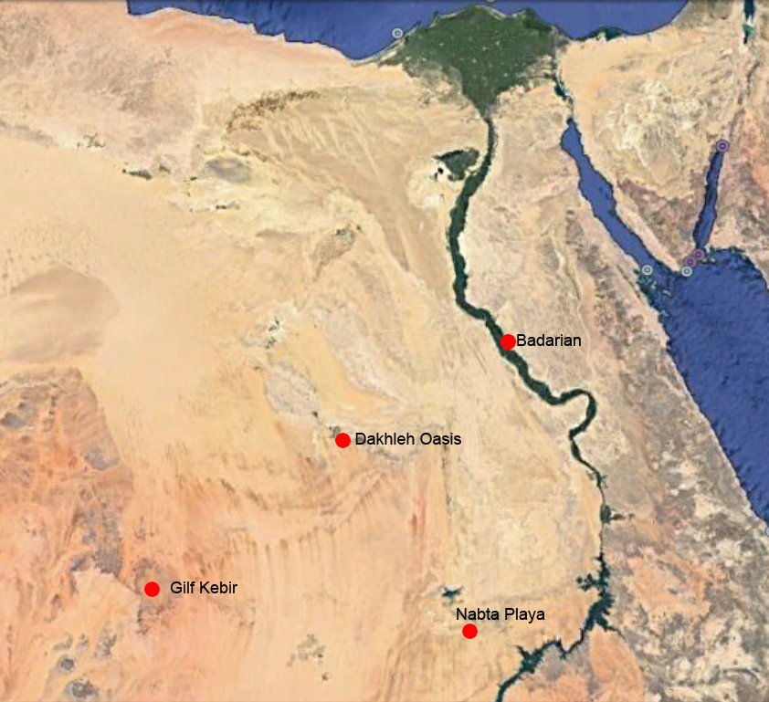 Figure 6.1 – The four areas discussed in the case studies (Source: Google Earth)
In exploring the marginal environments of the eastern Sahara, often with problematic datasets, I have chosen to push the data as far as I can, to find reasonable explanations. These would benefit from further analysis and, where possible, testing. In the case of the Badarian, this means using publications from the early 20th Century and employing both disturbed and undisturbed contexts, extrapolating from often limited archaeological remains in a way that a less experimental approach would probably avoid. In the cases of Nabta Playa, Dakhleh and Gilf Kebir, the data consisted almost entirely of palimpsests, and again the data has been pushed its limits in order to explore the value of the SRL model for capturing, describing and discussing data. This demonstrates the range of possibilities represented by the data and offers the opportunity to create new hypotheses on which to base future research (Scarborough 2009, p.197). The SRL approach evinces both the sort of questions that can be asked, and how a richly informed perspective on a particular archaeological context can be produced.
In the next chapter the methodology for completing the case studies is discussed. In this chapter the four case studies are introduced.
6.2 Case Study Backgrounds
6.2.1 Case Study 1 – Nabta Playa
6.2.1.1 Introduction to the Ru’at el-Baqar Late Neolithic at Nabta Playa
Nabta Playa lies in the southeast of the Western Desert 30km north of the Sudanese border, approximately 100km west of the Nile Valley, which equates to a one to three day walk, (Wendorf and Schild 1998, p.98) in what is now hyper-arid desert. The term “playa” refers to the presence of seasonally water-filled lakes and pools in basins, which attracted various forms of animal and human life. Schild and Wendorf suggest that rainfall was brief, resulting in “shallow pools of water” that could have sustained people and animals for as long as it remained (Schild and Wendorf 2001, p.45). Because it was first identified in modern times it benefited from the application of modern excavation techniques and the recognition of the importance of multi-disciplinary approaches, involving archaeological, geological, geomorphological, faunal, botanical and other specialized skillsets being employed to extract as much data as possible from the material. The main sites are shown in figure 6.2.
 Figure 6.2 – Map of sites at Nabta Playa, annotated with a colour-coded key,
added to show sites mentioned in the text (Source: Wendorf and Schild 2001a, fig 1.2, p.5)
The earliest occupation dates to the early Holocene, during which hunter-foraging communities using distinctive Epipalaeolithic tool-kits moved into the area to take advantage of improved conditions and the presence of small game. During the mid-Holocene climate became increasingly arid as the ITCZ began to move south (Riemer and Kuper 2013; Kuper and Kröpelin 2006), but the desert areas were still capable of supporting life, with the introduction of domesticated animals assisting with this process of adaptation to what were probably increasingly stochastic climatic conditions. At Nabta the periods corresponding to the mid-Holocene are the Ru’at El-Ghorab or Middle Neolithic followed by the 100-year Post-Middle Neolithic Arid Phase. The basin was reoccupied during the Ru’at el-Baqar or Late Neolithic (5400 – 4650 Cal BC), abandoned again in the 50 year Post-Late Neolithic Arid Phase and reoccupied once more during the Bunat el-Ansam or Final Neolithic (Schild and Wendorf 2002).
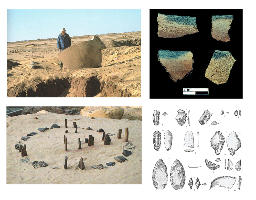 Figure 6.3 – Nabta Playa components during the Rua’t el Baqar. Clockwise from
top left, the shaped stone from Complex Structure A (Source: Wendorf and Schild 2002,
plate 36); black-topped ware (source: Nelson and Khalifa 2010, p.148, figure 4),
Articulated cattle skeleton from tumulus E-94-1N (source: Schild and Wendorf 2015, p.367, figure 24) and the stone cirlce at E-92-9 (source: Schild and Wendorf 2015, p.367, figure 24)
The Ru’at el-Baqar consists primarily of palimpsests, but stratified data has been found at the multi period site E-75-8. The period is defined mainly by inorganic remains, some of which are captured in figure 6.3 and are discussed in the case study. The ceremonial centre, consisting of a number of different features, also belongs partially to this period (Schild and Wendorf 2001b, p.44). The so-called megalithic components were not recognized until 1992, having been mistaken for bedrock (Wendorf and Schild 2001, p.9) and are divided across two periods with the tumuli and stone circle concentrated in the Valley of Sacrifices belonging to the Ru’at el-Baqar period (meaning “Cattle Herders”), menhir alignments and the so-called “complex structures” apparently straddling both Ru’at el-Baqar and Bunat el-Ansam (meaning “Megalith Builder”) periods (Schild and Wendorf 2004, p.11-14). Although some sites are placed within the Ru’at el-Baqar and some in the Bunat el-Ansam, Wendorf and Schild accept that the dating is not secure “and it cannot be determined conclusively whether or not the various units were built together or at different times” (2001a, p.9). However, on the basis of their excavations the CPE have divided the sites up between the two units, placing the stone circle, the tumuli, megalithic alignment A1 and Complex Structure E-96-1A in the Ru’at el-Baqar, and that scheme has been followed here. The publications used most frequently in this paper are Wendorf, Schild and Associates 2001 and subsequent papers. This is because publications prior to Wendorf, Schild and Associates 2001 do not distinguish clearly between the Ru’at el-Baqar and the subsequent Bunat el-Ansam, if at all. Some of the distinguishing features of the Ru’at el-Baqar are shown in figure 6.3.
6.2.1.2 History of excavation and analysis
Nabta Playa was found in 1973 by members of the Combined Prehistoric Expedition (CPE) who paused on the way to the Nubian Nile Valley. They recognized prehistoric lithics strewn on the desert floor, which led to the discovery of Nabta Playa, “a huge paleolake basin with hundreds of Stone Age camps, tumuli, groups of megalithic structures and alignments of stelae” (Schild and Wendorf 2004, p.11). Survey and excavation took place over a number of seasons: 1974-5 and 1977 (Wendorf and Schild 1980), 1990-2, 1994 and 1996 (Wendorf, Schild and Associates 2001) and 2001 (Wendorf et al 2005; Schild and Wendorf 2012).
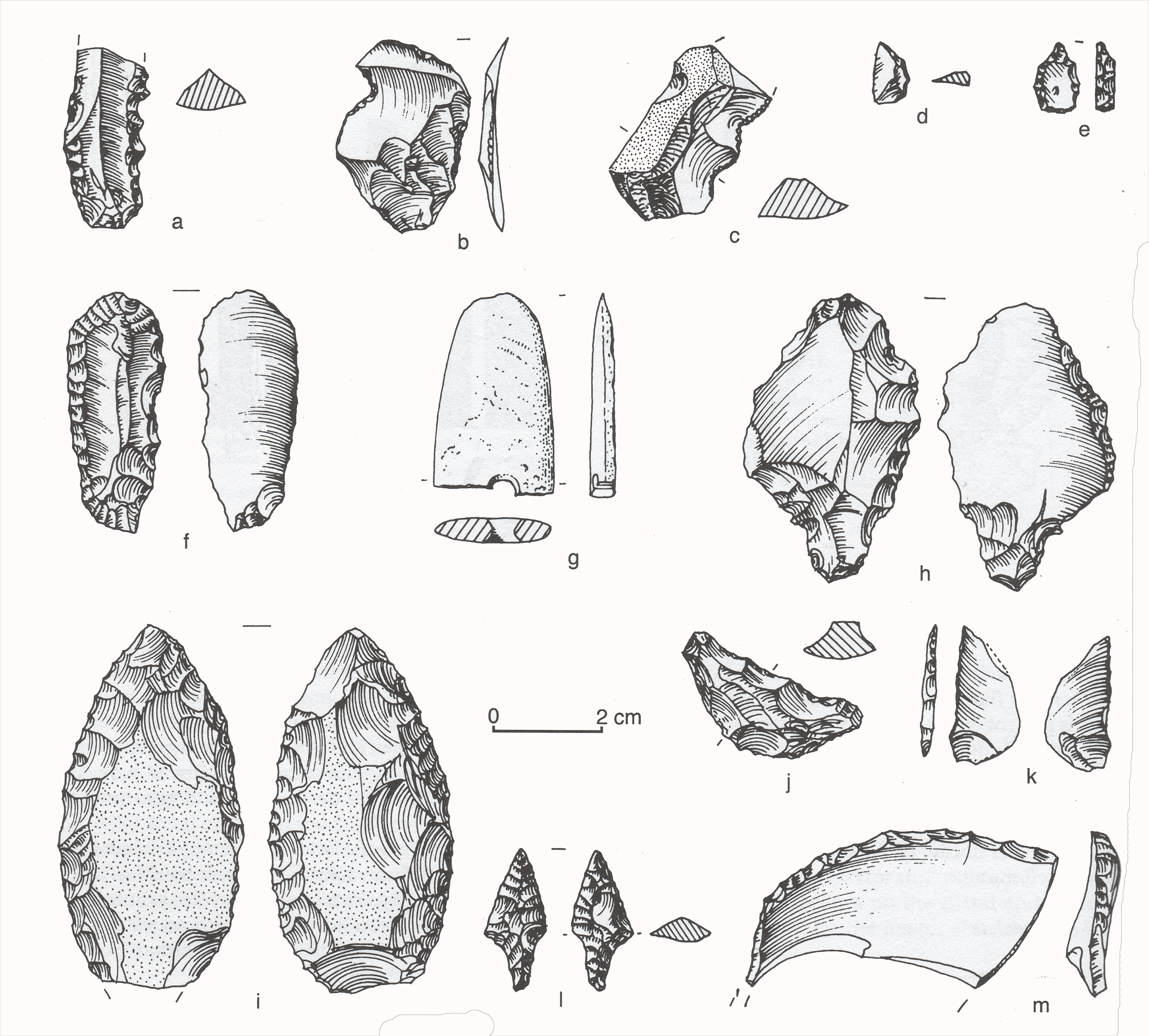 Figure 6.4 – Ru’at el Baqar lithics from E-75-8
(Source: Nelson 2001, p.396)
The excavations have been published as papers in both journals and books, and in two volumes dedicated to the site. Both of these two volumes (Wendorf, Schild and Associates 2001; Nelson et al 2002), together entitled Holocene Settlement of the Egyptian Sahara, consist of as a series of short excavation reports at different sites at different periods. Much greater emphasis is placed on the earlier Neolithic phases. The Ru’at el-Baqar and Bunat el-Ansam are still sometimes dealt with as a single unit, and the detail for the Ru’at el-Baqar is often difficult to isolate. Volume 2, dedicated to the pottery, presents a number of specific problems, including some minor inconsistencies, and an approach to the data that is only loosely structured. The first issue is that the detailed categorization of the pottery took place after the publication of Volume 1. The writers of the first volume did not have access to the analysis provided by the second, meaning that the terminology adopted in volume 1 is not used in volume 2, which makes it challenging to integrate the ceramic data in the two volumes. Additionally, the second volume focuses heavily on early Neolithic pottery, and Ru’at el-Baqar pottery is not discussed in as much depth. Again, the Ru’at el-Baqar and Bunat el-Ansam are sometimes dealt with as single units, which leads to some confusion within the volume. Finally, whilst the categories of pottery defined for the biggest of the Ru’at el-Baqar sites, E-75-8, were originally defined by Gatto and were described in Volume 1 without citation, presumably meaning the categories were unpublished (Nelson 2001, p.539), Nelson categorizes the ceramics in a different way in Volume 2, without further reference to Gatto’s scheme, meaning that it is difficult to integrate the two schemes.
6.2.1.2 Chronology
The Nabta Playa occupations consist of a mixture of both stratified and heavily deflated sites. The stratified sites have enabled a broad chronology to be developed, consisting of three early phases, a poorly represented middle phase, and both the Ru’at el-Baqar and Bunat el-Ansam Final Neolithic phases, each divided by periods of aridification when Nabta was abandoned. Each has been characterized in geological and stratigraphic terms (Schild and Wendorf 2002).
An emphasis has been placed on obtaining radiocarbon dates (Wendorf and Schild 2001c) and these are listed in the case study. More unconventional dates have been acquired from the stone circle and megalithic alignments based on estimates of the astronomy of the period, placing it within the Late Neolithic (Schild and Wendorf 2004, p.12). However, the dates for the ceremonial centre are by no means secure, only some of those are only indirectly associated with the sites concerned (Wengrow 2006, p.57). A map of the sites is shown in figure 6.5.
6.2.1.3 Origins of the Late Neolithic
When compared to previous periods, the Late Neolithic seems somewhat anomalous. The Early Neolithic, in three phases separated by arid episodes, corresponds to the early Holocene, a hunting and gathering economy associated with a microlithic bladelet technology and rocker-stamped large bowls based on local fabrics that was common in the eastern Sahara but which demonstrated regional variation (Nelson and Khalifa 2010, p.135). The following Middle Neolithic is poorly represented by again includes microlithic technology, this time with an increased proportion of flake tools, and ceramics similar to those of the Early Neolithic. Wendorf et al (1992-3) describe how lower parts of the basin contained settlements up to 5000m2, with wattle and daub buildings around 4-5m in diameter with central hearths, and smaller settlements of only 1-2 houses in lower parts of smaller basins. The major departure from the Early Neolithic in the Middle Neolithic is the village layout and the adoption of domesticated sheep and goat, followed by the introduction of cattle in the Late Neolithic. Following the post Middle Neolithic arid phase, cattle, sheep and goat are all represented during the Late Neolithic, but there are significant changes. The ceramic assemblage is completely reinvented, with a decorative paradigm moving from incised patterns on vessels to total-surface treatments. Lithic assemblages change, with flakes dominating, blades playing a minor role, and a change of raw material selection. At the same time novel ceremonial elements are introduced. The complete cultural contrast between earlier and Late Neolithic phases seems to argue that processes took place in the preceding arid phase when the deserts were uninhabitable and people were forced into areas where reliable water was available, possibly the Nile (Kobusiewicz 1992, p.136) perhaps interacting with other groups and exchanging technologies and ideas. The Terminal Abkan in Nubia may have been involved in this process, as it too featured Black-topped and Ripple wares, two of the four new forms of ceramic style (Gatto 2009; Hays 1984, p. 65-73, 217-218; Lange, M. and Nordström 2006, p.299). However, it is still very unclear how the Late Neolithic developed.
6.2.2 Case Study 2 – Badari (Qau el Kebir to Matmar)
6.2.2.1 Introduction to the Badarian
The Badarian extends over a 35km stretch of land parallel to the Nile, from just south of Asyut in the north to Qau el-Kebir (also known as El Etmanieh) in the south, the core areas being Badari, Mostagedda and Matmar. Although Brunton’s records and maps do not tally precisely, it consists of several clusters of sites, which add up to some 46 settlement sites in total, with around 42 cemeteries containing, between them, over 500 excavated graves (Brunton and Caton-Thompson 1928; Brunton 1937, 1948). The most recent dates available put the Badarian at between 4400 and 3800BC (Wengrow et al 2014).
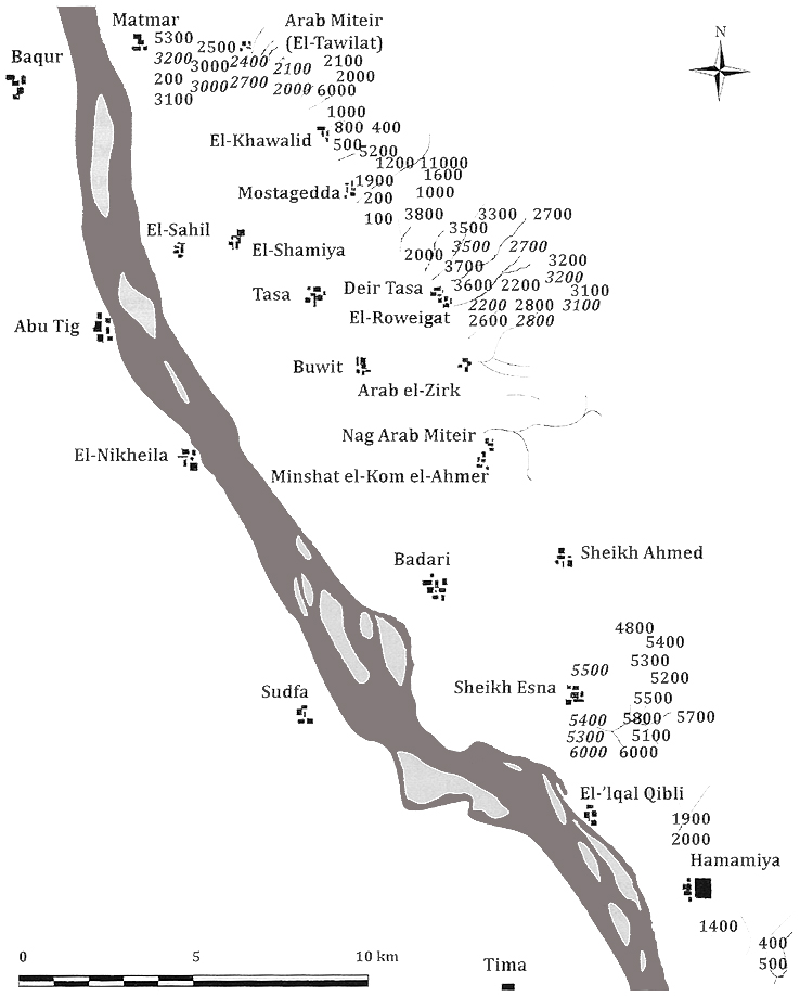 Figure 6.5 – Map of the Badarian sites (Source: Tassie 2014, p.249)
Occupation evidence is much more fugitive than funerary remains, and this may be a) because the Nile has changed its course, thereby destroying prehistoric data, b) because more recent villages have been built over the top of the prehistoric sites, c) because settlements were so transient that they are not there to be found or d) because settlement sites were on the opposite side of the Nile. Occupations consist of scattered remains of ash, debris, and occasional hearths and storage features (Brunton and Caton-Thompson 1928). By contrast, the cemeteries are very content-rich with grave goods consisting of ceramics, both fine and coarse, a generalized flake and blade industry with a small bifacial component (Holmes 1989), items of jewellery and ornamentation, small sculptures and cosmetic items (Brunton 1929, 1937, 1948; Brunton and Caton Thompson 1928; Friedman 1994; Holmes 1989a, Holmes 1989b). The economy is much debated and will be discussed in the case study. A sample of some of the objects found in Badarian sites are shown in figures 6.6 and 6.7.
 Figure 6.6 – A range of artefacts from Badarian graves
(Source: Tassie 2014, p.257, figure 77)
6.2.2.2 History of excavation and analysis
The excavations ran over three seasons, 1922-3, 1923-4, and 1924-5 (Brunton 1929; Brunton 1929b; Brunton 1937; Brunton 1948; Brunton and Caton-Thompson 1928). Excavation standards were advanced for the period, but the publications were by no means as detailed as modern reports, as already discussed in Chapter 1.
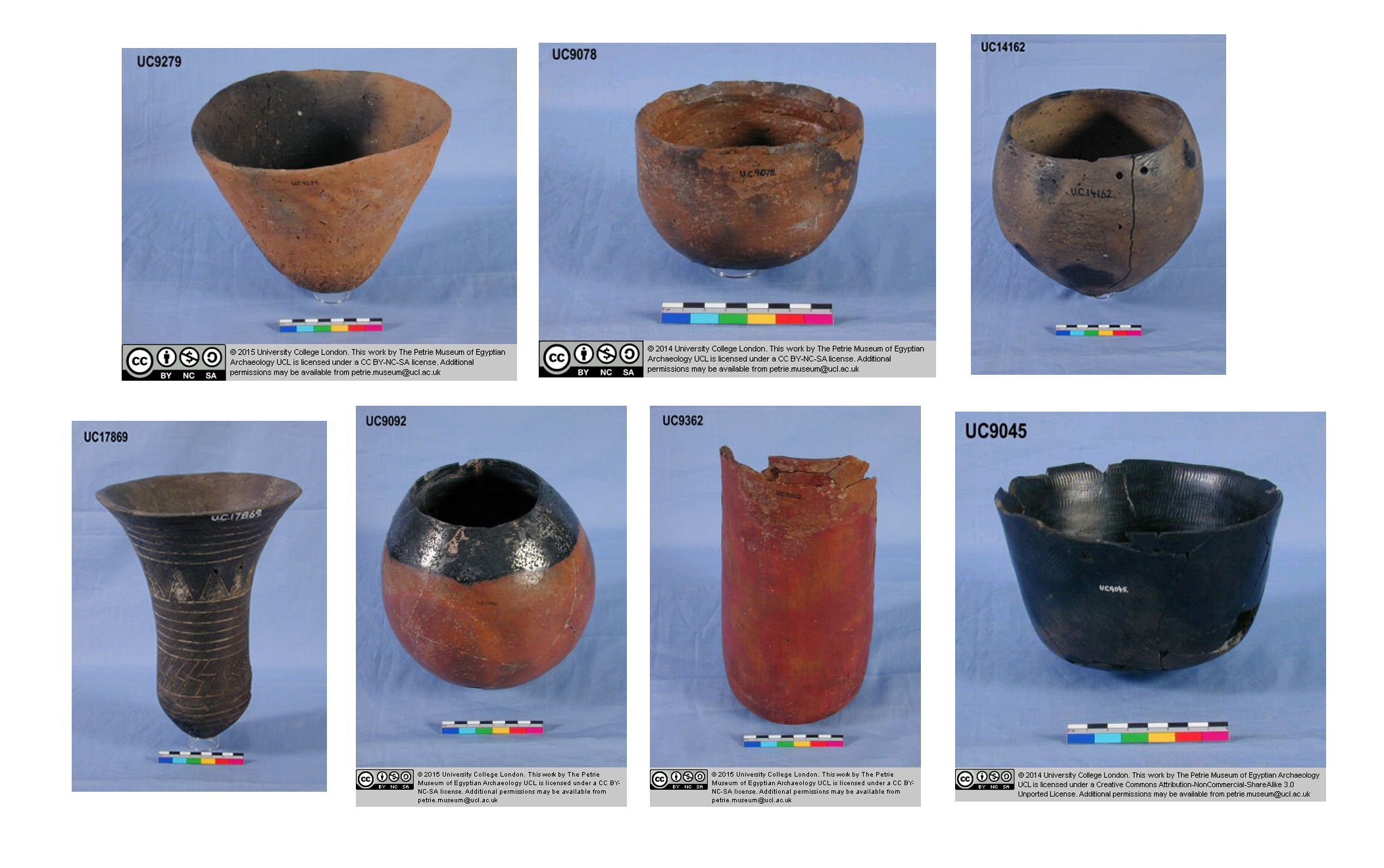 Figure 6.7 – Examples of ceramics from the Badari region
(Source: Petrie Museum of Egyptian Archaeology)
More recently, fieldwork by Holmes and Friedman was carried out in a two week survey between February and March 1989, during which they excavated two test pits at Hemamiyeh, incorporating a sequence from the Badarian to Naqada II (Holmes and Friedman 1989, 1994). As well as re-examining Brunton’s and Caton-Thompson’s excavations in the same area, they found a previously unrecorded site, where they excavated one test pit, which they named BD-1. In 1992 a second season carried out surveys at other sites, during which the Badarian Site 3400 was test excavated (Holmes 1993), with a test pit, 2m x 4m, producing 342 sherds and 2112 lithic artefacts.
Several sites outside the core area of the Badarian concentration of settlements and cemeteries have been judged by some writers to be Badarian. Of all of them, Maghar Dendera 2 is the most important. On a narrow part of the floodplain, with considerable amounts of Badarian type pottery, it seems to be a Badarian outlier used for herding and some hunting, with a large fishing component (Hendrickx et al 2001; Vermeersch and Hendrickx 2002). Consisting of hearths, storage pits, emplacements for vessels and some postholes (albeit with no evidence of walls) the lithic assemblage differed from other Badarian sites suggesting to the excavators that it was a specialized seasonal occupation. Gabra found Badarian remains to the south of Deir Tasa (1930) including a settlement site 5000m sq. As with the occupation sites excavated by Brunton, the site was very shallow and of variable depths and there were pits interpreted as granaries and hearths.
Examples in the Qena bend may be other outliers of the Badarian (Darnell, D. 2002). Hays considered sites at El Khattara to be Badarian, even though they are over 100km to the south (Hays 1984, p.72) but Hassan and Matson place them in the early Naqada (Hassan and Matson 1989, p.314). An example from Hierakonpolis (Hoffman 1979; Holmes 1988, p.82) is slightly later, as are examples at Armant where Mond and Myers assigned 30% of the pottery at the lowest level of the Armant Bucheum 1000 to the Tasian/Badarian (Mond and Myers 1937, p.169-11).
Elsewhere, Murray and Derry (1923) located a recently plundered grave around 5 miles inland due west of the Ras Samadi headland on the Red Sea coast on a small tributary on the Wadi Samadi. It was surrounded by a ring of large stones and had a roughly circular outline with a depth of 3 feet. Resch (1964) suggested that it was consistent with the Badarian. Debono (1951a, 1951b) found evidence for the occupation of a site at Laqeita oasis near Wadi Hammamat, the main route between Upper Egypt and the Red Sea today with pottery dated by Debono to the Badarian and Naqada I periods. At El Gouna near Hurghada on the Red Sea coast Vermeersch, Van Peer et al (2005) located a hearth at the foot of a limestone hill that have affinities to the archaeology of the Badari region. Finally, excavations at the Wadi Atulla revealed a severely plundered site that may have been connected to the Badarian (Friedman and Hobbs 2002).
There have been numerous pieces of academic research based completely or partially on the work of Brunton and Caton-Thompson, many of them looking at specific aspects of the Badarian, like the lithic industry (Holmes 1989); pottery (Friedman 1994); differentiation between the Tasian and the Badarian (Friedman and Hobbs 2002; Tassie 2014; Horn 2017a, 2017b); social structure (Anderson 1989, 1992), symbolic expression (Horn 2010; Wengrow et al 2014); seriation (Newell 2010), and the question of whether turquoise and copper from Sinai are present (Andelkovic 1995; Brunton 1929, p.463; Finkenstaedt 1983; Horn 2015; Tutundcizk 1989). It has also been summarized and discussed in a number of books about early Egypt (Baumgartel 1955; Hayes 1964; Hoffman 1979; Midant-Reynes 1992/2000; Romer 2012; Tassie 2014; Wengrow 2006).
Although there have been calls for further excavations to be carried out before destruction by expansion of modern settlements, encroachment by modern agriculture and the extension of cemeteries (Hoffman 1979; Holmes 1988; Holmes 1992; Holmes and Friedman 1989; Holmes and Friedman 1994), this was not acted upon and it is probable that all opportunities for using modern techniques to clarify the Tasian and Badarian along the Nile are now permanently lost (Holmes 1993, p.21), although it would be worth considering options for surveying the wadis, low deserts for sites and the western bank of the Nile as additional resources.
6.2.2.3 Chronology of the Badarian
The internal chronology of the Badarian is opaque. Caton-Thompson’s excavation of the stratified settlement site Hemamiyeh established that the Badarian predated the Naqada I period. Brunton assigned sequence dates to the Badarian based on stylistic features (Brunton and Caton-Thompson 1928, p.26), following Petrie’s seriation system. However, the proposed internal chronology, developed before algorithmic seriation techniques were available, has been challenged (Friedman 1994; Horn 2017a; Math 2007; Newell 2012, p). Friedman concluded that there is not sufficient evidence from the ceramics to distinguish between sub-phases in the Badarian (Friedman 1999, p.9). The practical consequence of this is that the Badarian is often treated as a palimpsest, because there is no confidence in any proposals of internal chronology.
The duration of the Badarian period has been assessed using scientific dating techniques. A series of thermoluminescence dates were taken from sherds found at Hemamiyeh (Caton-Thompson and Whittle 1975). Hoffman considered them to be “internally consistent”, suggesting that the Badarian had a lengthy duration and, together with radiocarbon dates, suggest a span of 5500-3800BC for the Badarian (Hoffman 1979, p.142). This is now considered to be too early. The only secure internal distinction observed is defined by a natural formation that Caton-Thompson calls breccia, which seals largely undisturbed deposits below and has deposits that overlie it. Accelerator dates from a midden at Badarian settlement Area 3400 near Deir Tasa provided dates that were c.200 years older, suggesting that the earliest levels at Hemamiyeh do not represent the earliest Badarian phase (Friedman 1994, p.348). Dee et al (2013) have provided a range of dates for the Badarian from 4407-4308 – 3800-3667BC (68%) or 4489-4266 – 3896-3616BC (95%).
Brunton divided the area occupied by Badarian sites into an earlier Tasian and a later Badarian phase (1937, p.32). Brunton acknowledged the difficulties of separating the two burial classes, referring to it as “a very difficult question,” acknowledging that it is “possible that in many cases the description as Tasian is not warranted” (1937, p.5). He referred to the available knowledge of the Tasian as “very elementary” (1937, p.8). However, he decided to distinguish between the two even when only slight Tasian affinities were present. The Tasian was defined by a small number of artefact types that Brunton considered to be diagnostic (Brunton 1937, p.25-32). Kaiser accepted the existence of a Tasian but saw it as the outcome of northern traditions, evolving into the Naqada I period, pushing any Badarian populations out of the area (Kaiser 1985). More recently, surveys and excavations by Friedman and Hobbs in the Eastern Desert (Friedman and Hobbs 2002) and by Deborah and John Darnell in the Western Desert (Darnell, D. 2002; Darnell, D. 2008; Darnell, J.C. 2002; Darnell and Darnell 1998) come close to supporting Brunton’s original proposals, positioning the Tasian as a desert tradition found in multiple environments in a number of different areas, perhaps originating from the Sudan (Darnell and Darnell 1998, p.80). On the other hand, other writers dismiss the Tasian as a chronological or cultural unit (e.g. Baumgartel 1955, p.20-21; Holmes 1989, p.14; Holmes 1993, p.24). Most recently and convincingly, Maarten Horn has argued in two papers that there are no grounds for separating the Tasian and Badarian. In one paper Horn argues that in the Qau to Matmar region the Tasian cannot be distinguished from the Badarian on the basis of objects, personal ornamentation or grave arrangements, and the inferences that can be drawn from them in terms of identity and technology (Horn 2017a). In the other paper (Horn 2017b) Horn analyses the practice of burial-superimposition, which he concludes is an intentional funerary practice and that Brunton’s two phases actually represent a single archaeological unit. As Wengrow et al observe, this is consistent with practices shared along the Sudanese Nile in the fifth millennium BC (Wengrow et al 2014). Darnell and Darnell (1998) believe that the Tasian sites in the region of Wadi el-Hôl in the Qena bend were not chronologically distinct from the Badarian but “rather a nomadic people with whom Badarian and Amratian cultures interacted” (1998, p.80), which seems like a plausible solution to the dilemma.
Finally, Newell’s seriation of the Badarian material based on pottery and palettes, both common in graves defines two phases, with open ceramics earlier and closed forms later in the sequence, and a change from round-based to flat-based designs (2012). He admits, however, that this has limitations and suggests that his conclusions might be challenged by future research. The big difference between Brunton and Newell is that Newell proposes a different order of interment of bodies within the individual cemeteries. At this time neither scheme is secure, and it is hoped that Horn’s research will be able to tackle some of these problems.
6.2.2.4 Origins of the Badarian
The origins of the Tasian and/or the Badarian are not obvious. The aggregated proposals by various researchers cover a complete spectrum of possibilities. The Badarian does not seem to follow on from any previous occupation in the area. The area between Minya and Asyut has produced a few objects that their excavators believed to be Neolithic, for example at Sheikh Timai and Jebel Sheikh Embarak, but further excavations need to be carried out to clarify the situation (Tassie 2014, p.248). Excavations of the cultural unit known as the Tarifian do not bear sufficient similarities with Badarian material to be considered ancestral to it, or directly influential upon it. It seems clear that the Tarifian was a completely separate tradition preceding the Badarian that did not give rise to the Badarian (Friedman 1994, p.17; Holmes 1988; Ginter and Kozlowski 1984). Six Tarifian sites were located on the west side of the Nile between Armant and Thebes, characterized by a flake and blade industry made on local flint, resembling some aspects of the post-Shamarkian industry of Nubia, with some pieces showing bifacial retouch. Pottery was only found in the form of small fragments, were only very rarely decorated, and then only with slanted marks, and represent only a restricted number of forms (Ginter and Kozlowski 1984). It is interesting, however, that a Sudanese connection has been suggested for the Tarifian, (Tassie 2014, p.245) which would, if verified, suggest that Sudanese inhabitants were aware of the area prior to the Tasian/Badarian.
The most common causal explanation for the settlement of the Badarian is climate change that forced people to abandon areas that are now desert and move into the Nile valley and elsewhere (e.g. Caton-Thompson 1952, p.40; Hassan 1986; Nordström 1972, p.24), and this seems plausible given the climatic data (see Chapter 3), but does not explain the very distinctive and apparently mature material culture in the Badarian. Kaiser (1985) proposed that the north was the source of Badarian settlers, as did Arkell and Ucko on the basis of the shared feature of flat-bottomed vessels. Krzyzaniak believed that it originated in the east (Krzyzaniak 1977), a suggestion not ruled out by Holmes (1989) due to the value of the Eastern Desert as a hunting resource. Others highlight similarities with sites to the west in the desert, including use of domesticated livestock, lithic industries, and personal ornamentation (Hassan 1978, 1979, 1986b; Holmes 1989, p.384; Hope 2002; Kobusiewicz et al 2004; Hendrickx and Vermeersch 2000; Huzayyin 1939, 1941; Kobusiewicz et al 2004; McDonald 1991b, 1996; Nelson 2002, p.18; Riemer and Kindermann 2008). However, although there are considerable similarities between Gebel Ramlah cemeteries in the Nabta Playa area of the Western Desert (to which Wengrow et al 2014 draw attention), there are also considerable differences, and Irish’s analysis of dental remains suggests that Gebel Ramlah and Badarian samples differed on 22 traits (Irish 2006). Keita’s analysis of craniometrics and linguistic information suggests that Badarian people belonged to a Saharo-Nilotic ancestry, with greater resemblance to the southern Nile valley than areas to the north (2006, p.763).
Others see strong similarities with Sudanese Khartoum Neolithic and Abkan archaeological remains, particularly use of cattle, pottery, settlement profiles and burial traditions that include personal ornamentation (Arkell 1975; Brunton and Caton-Thompson 1928; Friedman 1994; Hays 1984; Hendrickx and Vermeersch 2000; Keita 1990; Wengrow 2001; Wengrow et al 2014). The pre-Neolithic graveyard at el Barga, near Kerma, which dates to the first half of the 8th Millennium Cal. BC was the first in the Nile valley to show evidence of funerary offerings including palettes, pottery, exotic stones and items of jewellery (Gatto and Zerboni 2015), indicating that this type of burial had a long tradition in the eastern Sahara. Gatto suggests that the Badarian was the outcome of direct movements of people from Nubia north into the Badarian region (2009, p.24-5), a view supported by Wengrow et al 2014 who point to an earlier but similar mid Holocene pastoral Nile tradition in the Sudan, “suggesting a possible spread from south to north during the fifth millennium” (p.102). Gatto 2009 sees the Tasian and Badarian as part of the Nubian tradition, with a separate northern tradition divided by a cultural boundary somewhere between Tasa-Badari and the Faiyum-Merimde (Gatto 2009, p.132). It does seem clear is that the Tasian and Badarian were the result of one or more migrations into an area either not occupied at all or occupied by very different traditions that did not survive in this area, because the bifacial features of the Badarian certainly did not come from the south.
Bifacials are very much a feature of the oases and the north. The strongest connections appear to lie with both the Sudanese and desert traditions, perhaps suggesting that Sudanese traditions did indeed move north with people, but that these were combined with more northerly traditions. Sickle blades were associated with non-agricultural communities in Farafra, so did not simply emerge with agriculture which use-wear indicates were used for harvesting plant stems, and which Lucarini’s experiments show were highly effective for cutting domesticated wheat (Lucarini 2014b, p.367). In all, the combination of northern and southern traditions at Badarian sites seem to argue for a blending of traditions, rather than a single source.
6.3.3 Case Study 3 – Gilf Kebir
6.3.3.1 Introduction to the Gilf C period at the Gilf Kebir
The Gilf Kebir Holocene occupation consists of four phases, which extend from the early Holocene to the very end of the mid-Holocene (Gehlen et al 2002). Gilf C (4300-3300BC) was preceded by the Epipalaeolithic Gilf B (6500-4300BC). Pottery was introduced into the Gilf B at the end of the period (Gilf B2) but the Gilf C is the first Gilf Kebir phase to feature domesticated cattle, goat and sheep (Linstädter 2005g, p.361-363). The data takes the form of palimpsests of pottery and stone tools. There are no stratified contexts dating to Gilf C. Rock art makes up another dataset, and this has been tied convincingly into the archaeological record and analysis by Zboray (2003a, 2003b, 2009) and the ACACIA Group from the University of Cologne (Kuper et al 2011-1; Kuper 2013). Extreme aridity and lack of modern agriculture or settlement has preserved sites, but high levels of aeolian activity and erosion mean that very few faunal and fewer botanical remains have been found, and it has been difficult in all but a few cases to relate these with confidence to any of the four periods (Peters 1988). Tourism has become a problem in recent years as visitors to the area have taken home artefacts as souvenirs or moved them away from their find places into attractive arrangements (Bagnold 1982 p.vii; Förster et al 2010; Kuper 2002, p.1; Linstädter 2003a).
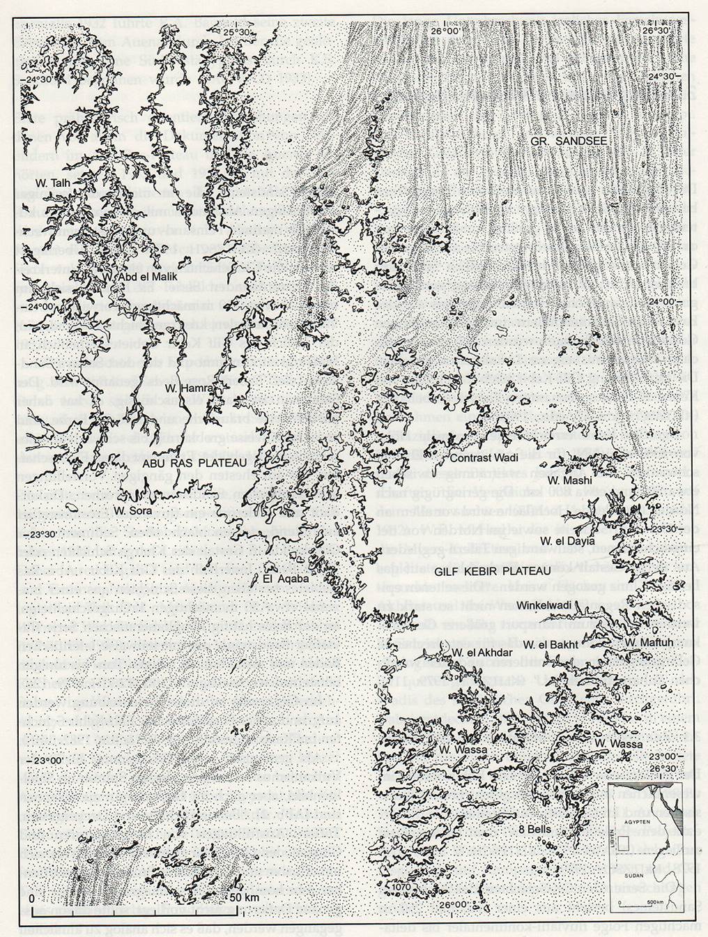 Figure 6.8 – Map of the Gilf Kebir showing the main wadis where the sites
mentioned in the text are located (Source: Schön 1996, p.20)
Gilf C sites are confined mainly to the southern Kemal el-Din or Gilf Kebir plateau, but there are some on the northern Abu Ras plateau as well (Kuper et al 2009a Linstädter 2003a; Linstädter and Kröpelin 2004; Schön 1996b). Most of the Gilf C rock art is found on the western flank of the Abu Ras plateau in the vicinity of Wadi Sura (Honoré 2017; Zboray 2009). The main concentration of occupation is divided between the dry run-off valleys of the Wadi el-Akhdar and Wadi el-Bakht, which benefited from the formation of seasonal lakes behind dune barriers, and other smaller and less permanent camps on the plateau. By the end of this period archaeological remains are restricted to Wadi el-Bakht, the dune barrier at Wadi el-Akhdar having been breached, abruptly draining the seasonal lake behind it (Kröpelin 1989). The vast majority of sites are palimpsests, some of them multi-period. Apart from rock art there are no indications of ceremonial activities.
 Figure 6.9 – Gilf C artefacts Top: Ceramics (source: left Classen and Pastoors 2005,
p.275, figure 6; right Kuper, Leisen et al 2009a, p.18, figure 18); Second row:
Gilf-type grinders (source: Kuper et al 2010, p.22, figure 24); Bottom row:
Lithics (Source: Gehlen et al 2002, p.106, figure 13)
Over the last few years it has become increasingly clear that the Gilf Kebir should not be considered in isolation, but as part of a broader pattern that includes the Jebel Uweinat massif 120km to the south, some 10 days away, and the much smaller massifs Jebel Arkenu, 20km to the northwest of Jebel Uweinat and Jebel Kissu, 25km to the southeast (Darius 2013; Darius and Nussbaum 2007; Honoré 2017; Menardi Noquera et al 2005; Zboray 2013).
Although the rock art has received a lot of attention, with Zboray alone having organized multiple expeditions over the last 15 years (Zboray 2003a, 2003b, 2009, 2010; 2013), archaeological investigation is very much in its infancy and is confined mainly to surveys, some of them using Google Earth following recent restrictions on travel to the area (Peroschi et al 2014). Very little excavation has taken place, meaning that it is difficult to compare Jebel Uweinat directly to the Gilf C.
6.3.3.2 History of excavation and analysis
Although the earliest confirmed discovery of the Gilf Kebir was by Prince Kamal el Din and John Ball in 1925, who visited again in 1926 (Kelly 2002), most of the first serious survey work carried out at the Gilf Kebir in the inter-war years. In the 1930s the Zerzura Club was formed, an informal gathering of mainly military personnel stationed in Wadi Halfa on the Nile, at the Sudanese side of the border with Egypt. They began a search for the fabled site of Zerzura oasis (Beadnall 1931) and undertook expeditions by car, aeroplane and on foot, which were forerunners of a number of formal expeditions. Chief amongst these activities, from an archaeological point of view, were Egypt Desert Survey surveyor Patrick Clayton whose detailed maps of the Gilf Kebir in the 1930s and 1940s remain the most detailed to date (Clayton 1933a, 1933b); Ralph Bagnold, who identified archaeological remains (Bagnold 1931, 1933, 1935; Bagnold et al 1933; Bagnold and Harding King 1931); William Kennedy Shaw, who discovered rock art in the Gilf Kebir between 1934 and 1935 (Kennedy Shaw 1936); and explorer and Laszlo Almasy who discovered the Cave of Swimmers, now known as Wadi Sura I (Almasy 1939). Some initial work was also carried out on the geology and the environment of the Gilf Kebir (e.g. Cox et al 1933; Kennedy Shaw et al 1936). Many of these accounts of the exploration of the Gilf Kebir were published by the Royal Geographical Society, which contributed financial resources.
The first formal archaeological work took place when Ralph Bagnold and Robert Mond led three expeditions to the Gilf Kebir (Bagnold et al 1939). In the mid-1970s the lithics collected by Meyer during the Bagnold-Mond expedition were analyzed by McHugh (1975), who also recorded 697 potsherds. The last expedition before the war took place in 1938, and was sponsored by the Egypt Exploration Society. Funded by Robert Mond it is known as the Mond Expedition, and key members were Ralph Bagnold, rock art specialist Hans Winkler and archaeologist Oliver Myers. The archaeological material was not examined until McHugh made it the subject of his doctoral research (McHugh 1971). Leo Frobenius led two expeditions (Rhotert 1952) but the artefacts from these expeditions were destroyed in the Second World War.
The Combined Prehistoric Expedition carried out surveys and excavations in the area in the 1970s and published their preliminary findings (Wendorf and Schild 1980) but did not return. The Geological Survey of Egypt and NASA visited and carried out surveys (El-Baz and Maxwell 1982). Since 1980 extensive investigation has been carried out by the University of Cologne, first by the BOS (Besiedlungsgeschichte der Ost-Sahara) project between 1980 and 1992 and then by the subsequent ACACIA (Arid Climate, Adaptation and Cultural Innovation in Africa) project from 1995 onwards (Gehlen et al 2002; Linstädter 2005a; Linstädter and Kröpelin 2004; Schön 1996a, 1996b). A four-phase chronology (Gehlen et al 2002) combined the data from the Wadi el-Bakht and Wadi el-Akhdar (Csziela 1996; Gautier 1980; Kröpelin 1987, 1989; Linstädter 1998; 1999; McHugh 1975; Schön 1996a, 1996b, 1989) and this has been confirmed by more recent excavations (Linstädter 2005). Work at both Wadi el-Bakht and Wadi el-Akhdar have been published in two edited volumes (Schön 1996a, 1996b; Linstädter 2005), consisting of collections of excavation reports and multi-disciplinary analysis of sites of all periods, together with extensive plans, maps and illustrations, the main themes of which are summarized in the final chapters of each. The work at Wadi el-Bakht alone produced 138 sites, of which 18 were excavated and many others systematically surveyed (Linstädter 2005g, p.355). The emphasis of fieldwork has been on Gilf B sites, which are larger and more numerous and are associated with some remarkable rock art scenes. A second strand of work carried out by the University of Cologne is the Wadi Sura-Projekt, and has focused on the rock art of the northeastern Gilf and its associated archaeology in and around the Wadi Sura rock shelters, again mainly Gilf B, published mainly online in a series of interim reports covering their work between 2009 and 2011 (http://wadisura.phil-fak.uni-koeln.de).
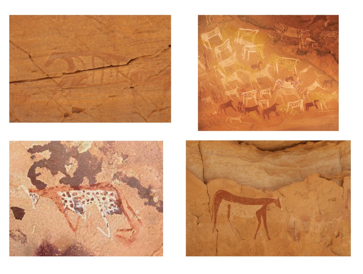 Figure 6.10 – Cattle paintings in the Gilf Kebir. Clockwise from top left:
Wadi Sura I (photgraph Andie Byrnes); WG25 (Source: Zboray 2013, p.19) ;
Wadi Sura I (photograph Andie Byrnes); AM51, Wadi Abd El Melik,
(Source: Zboray 2010, p. 242, figure 2)
Both rock art styles and archaeological excavation in the immediate vicinity of Wadi Sura II have helped to tie in the rock art with the four occupation phases, most belonging to Gilf B and Gilf C (Honoré 2015, 2017; Kuper et al 2011-1; Kuper 2013; Zboray 2003a, 2003b, 2009, 2010, 2013). The main distinguishing factors dividing Gilf B and Gilf C rock art are the change of subject matter, and the different styles of execution. Gilf B scenes focused on hunting and scenes of socializing accompanied by headless mythical creatures, whereas Gilf C scenes are focused almost exclusively on livestock, mainly cattle, as shown in figure 6.7.
Most of the climatic data for the area is based on the excavation and analysis of the section of breached dune playa sediment, site 82/13, which provides “the thickest and most detailed sedimentary archive of Egypt’s entire Western Desert” (Linstädter and Kröpelin 2004, p.756). Extensive Gilf C settlement remains have been found in the wadis of the eastern edge of the southern plateau and the northern edges of the northern plateau. Whereas the northern plateau sites are largely Gilf B pottery-users who made use of temporary playa lakes at the foot of the cliffs, the southern plateau sites, with temporary lakes formed behind barrier dunes in dry wadis, date to both Gilf B and the later pastoralist Gilf C. The Gilf D has been found only at the southeastern part of the southern plateau to date, represented by very few sites.
6.3.3.4 Chronology
The four-phase chronology to be developed, combining the data from Wadi el-Bakht and Wadi El-Akhdar, has been mentioned above (Gehlen et al 2002; Linstädter 2005a, 2005b). The Gilf A (8300-6800BC) is a hunting occupation represented by elongated triangles, backed points and microlithic and burins on blades, dating from 8100 BC (Gehlen et al 2002). Gilf B, formerly called the Middle Neolithic and corresponding to Wendorf and Schild’s Middle Neolithic (Gehlen et al 2002), is a much better represented hunting occupation with pottery (6800-430BC). Following a period of abandonment pastoralists moved into the area during Gilf C with cattle, sheep and goat, taking advantage of the temporary lakes formed behind dunes that crossed dry wadis (4300-3500 BC). Gilf C was formerly called the Late Neolithic and corresponds to Wendorf and Schild’s Ru’at el-Baqar (Gehlen et al 2002). The character of sites was very different from Gilf B (Gehlen et al 2002; Fäder 2005; Linstädter 2003, p.136; Linstädter 2005g, p.366; Schön 1996b, p.127; Von Czerniewicz 2005, p.223-5). The Gilf D is a more ephemeral period, with a return to hunting and gathering and, if the identification of cattle is correct (Cziesla 1996) perhaps with small numbers of livestock (3200-2700 BC).
7.4.1. Case Study 4 – Dakhleh Oasis
7.4.1.1 Introduction to the Bashendi B
Dakhleh Oasis is located in the Western Desert, one of a crescent of four very large discrete oases running south to north, west of the Nile. Dakhleh is 600kms south of Cairo, 250kms west of the Nile. Its overall area is 2000 square kilometres, extending some 80kms east to west and 25kms north to south (figure 6.11). Today Dakhleh has a population of around 75,000 inhabitants spread across a number of small towns and agricultural villages throughout the oasis. The oasis sits in a depression c.92-140m above sea level and is bordered by the 300-500m high Egyptian Limestone Plateau to the north, the southern edge of the Libyan Plateau (Kleindienst et al 1999, p.1-2; Riemer 2011, p.24-28).
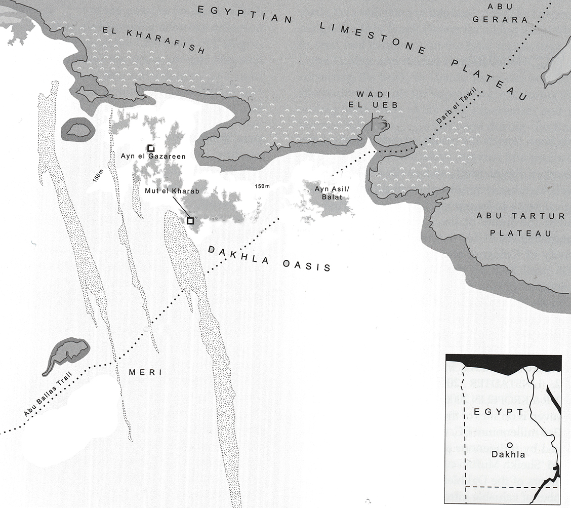 Figure 6.11 – Map of Dakhleh Oasis showing the Limestone Plateau
behind it. (Source: Riemer 2011. P.18, figure 1)
The prehistoric remains belonging to the Bashendi B follow occupation from the Lower Palaeolithic onwards, and the oasis provides an interesting example of a nearly complete sequence from prehistoric to historic times. The oasis is fed by the Nubia Aquifer described in chapter 3, and also seems to have benefitted from bimodal rainfall supplied by the collision of monsoonal and temperate weather fronts. Examples of the lithics and ceramics from the Bashendi B are shown in figure 6.12 and figure 6.13.
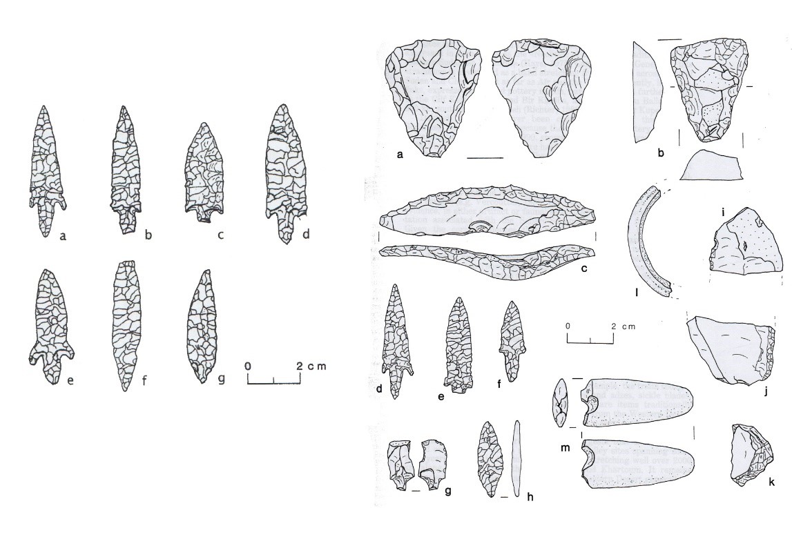 Figure 6.12 – Lithics from Dakhleh Oasis. (Sources: McDonald 3013, p.185,
figure 7; McDonald 1991, p.49)
7.4.1.2 History of excavation and analysis
The Dakhleh Oasis Project was established in 1977, and was granted the concession for the entire area of the oasis not covered by the Institut Français d’Archéologie Orientale, who were investigating historical periods and were not concerned with prehistoric sites. The Dakhleh Oasis Project (DOP), which adopts a multi-disciplinary approach, covers the entire span of Dakhleh’s past from earliest prehistory to recent historical times. Dr Mary McDonald is the lead prehistorian for the DOP, with contributing specialists focusing on specific periods and areas to build up an integrated understanding of the past of the oasis. In 1985 Lech Krzyżaniak joined the DOP project to set up the Petroglyph Unit for studying the engraved rock art in the oasis, on behalf of the Archaeological Museum in Poznań and the Polish Centre of Mediterranean Archaeology based at the University of Warsaw (Polkowski et al 2013). In addition the ACACIA team, based at the University of Cologne, have found Bashendi B and the subsequent Sheikh Muftah material remains in the desert areas beyond the oasis, expanding knowledge of the use of the combined use of desert and oasis at this time (McDonald 2016; Riemer 2003, 2006, 2011, 2013; Riemer and Kindermann 2008).
 Figure 6.13 – Ceramics of the Bashendi B. (Source: Hope 2002, p.44, figure 2)
Most of the sites are in areas that are now desert around the edges of the modern oasis. Some are undoubtedly under cultivated land, as is the case in the Nile valley. Because they are essentially desert sites, they are often in highly deflated condition, but as well as the usual inorganic remains, some organic remains have been found including bones, pollen and macrofossils and radiocarbon dates are available from numerous sites (McDonald 2016, p.182).
Some of the results of these strands of research have been presented at a four-yearly conference and are published regularly in the Dakhleh Oasis Papers monographs (Churcher 1999; Churcher et al 2008; Hope 2002; McDonald 1990, 1999, 2001, 2002b, 2008; Warfe 2003b). Papers are also scattered through various journals and edited volumes, for example: Churcher (2008), McDonald (1991a, 1991b, 1993, 1996, 1998a, 1998b, 2002a, 2006, 2009, 2013, 2016) and Warfe (2003a, 2003b). Warfe recently produced a volume dedicated to the ceramics of Dakhleh in 2018, based on his 2008 PhD (Warfe 2018). No equivalent exists for the lithic technology, and no detailed data has been published on core and debitage types, so there are some significant differences in the availability of the data between this and the other case studies. So far there is no single overview of the prehistory of Dakhleh and nor is there any web source dedicated to the subject, although various brief references to the prehistory investigated during the 2000-2008 field seasons are incorporated into reports saved on the Monash website: http://artsonline.monash.edu.au/ancient-cultures/excavations-in-dakhleh-oasis-egypt. The research by Woods (2016) into religion and ritual in the prehistory of the Western Desert includes Dakhleh but is exclusive to undated rock art and is not incorporated into the case study.
Similarities between Dakhleh and Kharga oases suggest that they should be treated as a single unit or units with close ties (McDonald 2006, p.4). Although work by the Kharga Oasis Prehistoric Project is still in its early stages and there are only a few publications to refer to (Briois 2007, 2012; Briois and Midant-Reynes 2010; Lesur et al 2011), Kharga will be mentioned occasionally throughout the case study.
7.4.1.3 Chronology
Research has resulted in a multi-phase chronology for Dakhleh’s prehistoric period. Following the onset of the early Holocene Dakhleh was re-occupied during the Epipalaeolithic, named the Masara. It is followed by the Bashendi A (6400-5600BC), at the end of which limited domesticated livestock was introduced. This was in turn followed by the fully pastoralist Bashendi B (McDonald 2002a). In the Early Bashendi A the most common sites are those associated with playa silts and extensive scatters of hearths. By the Late Bashendi A there is a clear indication that settlement was becoming more permanent, at least in parts of the oasis, with the introduction of goats supplementing the livelihood strategy (McDonald 2016). One of the main differentiators in the Bashendi B (c.5300-4000BC) is the addition of a substantial pastoral component based on cattle and goats, supported by traditional hunting activities and an increased use of ceramics, with significant changes in lithics and the absence of Bashendi A type stone-built hut circles. Bashendi B has the most evidence for connections with the Nile before the following Sheikh Muftah period (McDonald 2016). The long-lasting Sheikh Muftah period (3900-2200BC), which began during a period of aridification, lasted into the Pharaonic Old Kingdom period (c.2686-2181BC) (McDonald 2002a; Riemer 2011). The Sheikh Muftah appears to have been restricted to the oasis, probably due to the aridification of the surrounding area, but there is no indication of permanent settlement sites. Rock art data is not included in the case study as it has so far not been possible to tie in the rock art to the archaeological data (Polkowski et al 2013). This agrees with related research by Kobusiewicz and Kuciewcz (2015) and Polkowski (2015a, 2015b) who are unable to correlate Bashendi archaeological sequences and rock art data reliably.
7.1.4.4. Origins of the Bashendi B
Although there are differences between Late Bashendi A and Bashendi B contexts there are also many indications of continuity, and new radiocarbon dates are beginning to fill the apparent gap that previously existed between the two periods (McDonald 2012). The toolkit itself maintains connections with the Late Bashendi A whilst introducing new elements, arguing both for a continuity with previous activities and the need or desire for new functional components. It therefore appears that the Bashendi B emerges from the Bashendi A, but there were clearly contacts with areas outside the oasis. The pottery, for example, includes some locally made items, but Warfe’s analysis of the fabric used to make vessels indicates that others were probably imports. Possible outside sources for the pottery are Abu Gerara to the north, Abu Minqar to the west and Nabta-Kiseiba to the south (Warfe 2003a, p.84).
7.5 Conclusions
The above summaries provide a brief introduction to each of the case studies. Each case study uses data that has been mined from published material, with a view to seeing how published material can be put to use within the SRL model. The most complete case studies are the Ru’at el-Baqar and the Badarian due to the better quality of data and the greater information about the periods selected for discussion. The Gilf Kebir as a whole has been the subject of some excellent fieldwork, and publications have captured some of this, but the Gilf C remains somewhat elusive in publications. The Bashendi B of Dakhleh Oasis is the smallest of the case studies due to shortages of both actual and published data. All sources cited in the case studies are listed in the thesis bibliography.
Chapter 7 discusses the process by which archaeological data was incorporated into the SRL model. A template was created as a tool to assemble the case studies introduced above and to ensure that data was collected in a consistent and structured way in order to represent each area as completely as possible, bearing in the caveats discussed above.
